University of New Hampshire
University of New Hampshire Scholars' Repository
Master's Theses and Capstones Student Scholarship
Spring 2019
SCIENCE DIPLOMACY IN THE ATLANTIC
ARCTIC: ASSESSING POTENTIAL
EXPANSION OF THE DISTRIBUTED
BIOLOGICAL OBSERVATORY (DBO) TO
THE BAFFIN BAY-DAVIS STRAIT AREA
Claire EatonUniversity of New Hampshire, Durham
Follow this and additional works at:https://scholars.unh.edu/thesis
This Thesis is brought to you for free and open access by the Student Scholarship at University of New Hampshire Scholars' Repository. It has been accepted for inclusion in Master's Theses and Capstones by an authorized administrator of University of New Hampshire Scholars' Repository. For more information, please [email protected].
Recommended Citation
Eaton, Claire, "SCIENCE DIPLOMACY IN THE ATLANTIC ARCTIC: ASSESSING POTENTIAL EXPANSION OF THE DISTRIBUTED BIOLOGICAL OBSERVATORY (DBO) TO THE BAFFIN BAY-DAVIS STRAIT AREA" (2019).Master's Theses and Capstones. 1271.
SCIENCE DIPLOMACY IN THE ATLANTIC ARCTIC: ASSESSING POTENTIAL
EXPANSION OF THE DISTRIBUTED BIOLOGICAL OBSERVATORY (DBO) TO THE
BAFFIN BAY-DAVIS STRAIT AREA
BY
CLAIRE EATON
Bachelor of Arts, Political Science & Anthropology, University of Vermont, 2011
THESIS
Submitted to the University of New Hampshire
in Partial Fulfillment of
the Requirements for the Degree of
Master of Science
in
Natural Resources: Environmental Conservation
This thesis has been examined and approved in partial fulfillment of the requirements for the
degree of Master of Science in Natural Resources by:
Thesis Director, Dr. Catherine M. Ashcraft, Assistant Professor,
Department of Natural Resources and the Environment
Dr. Larry Mayer, Professor and Director
School of Marine Science and Ocean Engineering Center for Coastal and Ocean Mapping
NOAA/UNH Joint Hydrographic Center
Dr. Jennifer Brewer, Associate Professor
Department of Geography
On May 2, 2019
ACKNOWLEDGEMENTS
The goals of this research could not have been realized without the continued support of my
advisor, Dr. Catherine M. Ashcraft. I am grateful for the insights and encouragement you
provided throughout, and for the patience and perseverance you exemplified. Thank you for the
many opportunities that you helped me to identify and pursue. Thank you to my committee
members, Dr. Jennifer Brewer and Dr. Larry Mayer, for your feedback and guidance. I am also
grateful for Dr. Mayer’s support for my participation at the Rhodes Academy of Ocean Law and
Policy 2017 session in Rhodes, Greece.
I would also like to thank the members of UNH’s Environmental Planning, Policy, and
Sustainability (EPPS) lab for their ongoing support and feedback, as well as colleagues in the
Marine School and Center for Coastal and Oceanographic Mapping. I am most grateful for your
support and friendship. Thank you to Kristen Shake for support during the research design
process. Thank you to my friends and colleagues from various Arctic workshops and
conferences, including the ASIAQ cohort. You continue to be a source of boundless inspiration.
TABLE OF CONTENTS
COMMITTEE PAGE ... ii
ACKNOWLEDGMENTS ... iii
LIST OF TABLES ... vi
LIST OF FIGURES ... vii
LIST OF ACRONYMS ... viii
ABSTRACT ...x
CHAPTER 1: INTRODUCTION 1.1 Literature Review ...1
1.2 Research Questions ...16
1.3 Research Design & Methodology ...16
1.4 Thesis Outline ...30
CHAPTER 2: STAKEHOLDER GROUPS, INTERESTS, ISSUES & BARRIERS 2.1 Stakeholder Groups ...31
2.2 Stakeholder Interests ...35
2.2.1 Scientific Inquiry ...36
2.2.2 Broaden Geographic Coverage ...36
2.2.3 Maximize Shared Resources ...36
2.2.4 Reciprocal Standardized Data Sharing Protocols ...37
2.2.5 Increased Program Connectivity ...37
2.3 Stakeholder Issues & Associated Barrier ...37
2.3.1 Project Leadership ...38
2.3.2 Data Interoperability ...40
2.3.3 Data Sharing ...40
2.3.4 Data Management ...44
2.3.5 Community Relations ...45
2.3.6 Monitoring Equipment ...49
2.3.7 Research Platforms ...49
2.3.8 Coastal State Consent ...51
2.3.9 Coordination ...53
CHAPTER 3: OPPORTUNITIES 3.1 Collaboration ...55
3.1.1 Arctic Scientific Research: Historically Collaborative ...55
3.1.2 Perceptions of the Arctic Geopolitical Landscape ...56
3.1.3 Indigenous Community Engagement ...58
3.1.4 Institutional Support for a Baffin Bay Area DBO ...61
3.1.5 Potential for Private Industry Participation ...62
3.2 Design Opportunities ...63
3.2.1 Building Based on Lessons Learned ...63
3.2.2 Connecting with Community-Based Monitoring Programs ...65
3.2.3 The DBO and the BBOS (Baffin Bay Observing System): Separate or Connected? ...66
3.2.5 Must all DBO’s look the same? ...68
3.3 Potential Geographic Range for a Baffin Bay-Davis Strait DBO ...69
3.3.1 Key Focal Points for a Baffin Bay Area DBO ...71
3.3.2 How Far South? ...75
3.4 A Role for New England? ...74
3.4.1 Scientific Justification for Extension to the Gulf of Maine ...74
3.4.2 Opportunity for Increased Institutional Support ...76
CHAPTER 4: RECOMMENDATIONS, DISCUSSION & CONCLUSIONS 4.1 Recommendations ...78
4.1.1 Collaboration ...78
4.1.2 Design ...79
4.1.3 Sustainability...80
4.2 Discussion ...80
4.2.1 Pilot Study Considerations ...88
4.3 Conclusions ...89
APPENDICES Appendix A: IRB Approval ...91
Appendix B: Interview Protocol A – Researcher/Scientist/Practitioner ...92
Appendix C: Interview Protocol B – Policy/Agency/Management ...94
Appendix D: Query Strategy ...96
LIST OF TABLES
Table 1.1 Conflict Management Frames (Gray, 2003)
Table 1.2 Issue Categories Impacting International Scientific Collaboration
Table 2.1 Stakeholders Identified by Interviewees to Engage in DBO Expansion to the Baffin Bay-Davis Strait Region: Broad Categories
Table 2.2 Stakeholder Identified by Interviewees to Engage in DBO Expansion to the Baffin Bay-Davis Strait Region: Countries
Table 2.3 Stakeholders Identified by Interviewees to Engage in DBO Expansion to the Baffin Bay-Davis Strait Region: Regional Groups & NGOs by Country
Table 2.4 Stakeholders Identified by Interviewees to Engage in DBO Expansion to the Baffin Bay-Davis Strait Region: Government Agencies by Country
Table 2.5 Stakeholders Identified by Interviewees to Engage in DBO Expansion to the Baffin Bay-Davis Strait Region: Military Bodies by Country
LIST OF FIGURES
Figure 1.1 Pacific Distributed Biological Observatory (DBO)
Figure 1.2 DBO Interagency Partners
Figure 1.3 Pacific Arctic Group (PAG) Partners
Figure 1.4 Northeast Atlantic DBO
Figure 1.5 Circumpolar Arctic Map
Figure 1.6 AOS 2019 Working Group 2 Systems Mapping Example
Figure 1.7 Regional Map of Baffin Bay-Davis Strait
Figure 1.8 Interview Participants by Country
Figure 1.9 Interview Participants by Organization
LIST OF ACRONYMS
AAAS: American Association for the Advancement of Science
AOOS: Alaska Ocean Observing System
AOS: Arctic Observing Summit
BBOS: Baffin Bay Observing System
BIO: Bedford Institute of Oceanography
BOEM: Bureau of Ocean Energy Management
BSEE: Bureau of Safety and Environmental Enforcement
CBM: Community-Based Monitoring
DBO: Distributed Biological Observatory
DFO: Fisheries & Oceans Canada
EEZ: Exclusive Economic Zone
FIT: Florida Institute of Technology
ICES: International Council for the Exploration of the Sea
IOOS: International Ocean Observing Systems
IPCC: Intergovernmental Panel on Climate Change
MSR: Marine Scientific Research
NASA: National Aeronautics and Space Administration
NERACOOS: Northeastern Regional Association of Coastal Ocean Observing Systems
NESS: Northeast Science Station
NOAA: National Oceanographic and Atmospheric Administration
NRDC: Natural Resource Defense Council
NSIDC: National Snow and Ice Data Center
ODU: Old Dominion University
ONR: Office of Naval Research
OSU: Oregon State University
PAG: Pacific Arctic Group
QIA: Qikiqtani Inuit Association
RUSALCA: Russian-American Long-term Census of the Arctic
SAON: Sustaining Arctic Observing Networks
TK: Traditional Knowledge
UAF: University of Alaska, Fairbanks
UCAR: University Corporation for Atmospheric Research
UMCES: University of Maryland Center for Environmental Science
URI: University of Rhode Island
US FWS: United States Fish & Wildlife Service
UW: University of Washington
ABSTRACT
SCIENCE DIPLOMACY IN THE ATLANTIC ARCTIC: ASSESSING POTENTIAL
EXPANSION OF THE DISTRIBUTED BIOLOGICAL OBSERVATORY (DBO) TO THE
BAFFIN BAY-DAVIS STRAIT AREA
by
Claire Eaton
University of New Hampshire
The scale and rate of climate change in the Arctic has increased the sense of urgency
surrounding development of systems-level observing programs that aim to capture and analyze
time series data related to environmental change. While the international scientific community
has made great strides in program design and technological innovation, gaps in coverage remain
between observing systems, presenting a complex interdisciplinary problem, or “grand
challenge.” Research that aims to address global scale challenges, such as those faced in a
rapidly changing Arctic, are often associated with extremely high operational costs and typically
extend beyond the scope and capabilities of any one research organization, government, or
country. Therefore, the need to maximize resources through science diplomacy, or facilitation of
international scientific cooperation, has become critical to the success and sustainability of
long-term observing programs. The Distributed Biological Observatory (DBO) represents a case study
that can be examined within the context of science diplomacy to better understand the various
stakeholder groups, issues, interests, potential barriers, and opportunities associated with design
These findings present results from 16 interviews conducted with stakeholders from
2017-2018. This pilot assessment points toward a need to engage beyond the DBO’s original
stakeholder base of scientists in order to reach the broader range of groups who may be
interested in a Baffin Bay area program including indigenous communities, government
agencies, regional groups/NGOs, military bodies, private industry, and Arctic networks. A main
objective of this research is to create a framework for future analysis of cooperative international
CHAPTER 1: INTRODUCTION
Never has the need for international scientific cooperation in polar regions been more
urgent. Climate change is impacting marine ecosystems across the globe at an astounding rate,
but nowhere is affected more severely than the Arctic. Research teams from countries across the
globe are now working to gather insights into current trends and future scenarios related to
physical and biological change. Despite growing interest within both the scientific community
and national governments, those conducting marine research in the Arctic face a number of
technical, logistical, political, and resource-related challenges. These challenges present a serious
barrier to research efforts that could stymie scientific progress and related applications (e.g.,
climate change mitigation, biodiversity conservation, policymaking, etc.). In response, scientists
and governments are developing and expanding science diplomacy efforts, or facilitation of
scientific research through international cooperation.
A current example of such efforts is the Distributed Biological Observatory (DBO). The
DBO represents a case in which high-level, agency-to-agency cooperation surrounding Arctic
research has successfully led to accumulation of critically important biological and
oceanographic data that can be used to inform environmental governance, regional political and
economic strategy, and ongoing scientific research efforts. The main objective of this research is
to conduct a pilot stakeholder assessment of relevant actors engaged in Arctic marine research
and the DBO in order to characterize the parties involved, the key issues they find important, and
their interests related to these issues in order to facilitate future expansion to new parts of the
circumpolar system, such as the Baffin Bay-Davis Strait area.
Scientific Collaboration
Against the backdrop of increasing globalization, technological connectivity, and
dramatic environmental change, scientific collaboration has become more common and,
arguably, more important than ever before. Planetary-scale problems such as climate change
have stretched the resources, intellectual capacity, and technical abilities of organizations and
governments across the world and, to compound this already monumental challenge, the science
required to develop better strategies for predicting, preventing, and mitigating global change is
intimately intertwined with politics – at every geopolitical scale. Scientific research does not
occur in a vacuum; nor is it immune to the far-reaching effects of human behavior and
psychology. Instead, scientific research should be understood as a socially and politically
dynamic process that is not only influenced but defined by the stakeholders involved and the
broader cultural and political environment in which it is conducted. Sonnenwald (2008) defines
scientific collaboration as the interaction that occurs within a social context among scientists that
facilitates the sharing of meaning and completion of tasks toward a mutually shared goal.
Moreover, Sonnenwald points out that individual scientists bring specific personal goals to
collaborative research efforts – whether related to promotion, tenure, publication, funding, etc. –
which may influence their approach to collaboration, the way they conduct their work, and their
perspectives more broadly. While scientists may perceive themselves as purely objective, the
idea that science is conducted in a social and political vacuum is disavowed in contemporary
literature, particularly that related to climate change. In short, the scientific method does not
ensure political neutrality; and despite its intended rigor, researchers alone are responsible for the
multitude of discretionary decisions made throughout a process (Ozawa, 2007). Clearly, the
politics. A variety of literature outlines the effects of uncertainty (whether scientific or political)
(Berkman & Young, 2009; Edwards, 1999; Jasanoff, 1996; Ozawa, 2007), often suggesting that
as uncertainty increases, so does the complexity of factors influencing collaborative scientific
research. Climate change has significantly increased the level of difficulty and uncertainty
surrounding environmental decision-making, as well as the scientific efforts driving those
decisions. The current global atmosphere in which scientific research is conducted is more
politically uncertain as a result of changing administrations and fluctuations in government
support (both within the US and in other countries), and also scientifically uncertain due to the
dramatic physical and biological shifts occurring as a result of climate change. Despite this
atmosphere of intense uncertainty, public and private funding agencies alike have increasingly
called for international, interdisciplinary, inter-institutional collaboration (Sonnenwald, 2008).
Some funding opportunities are being exclusively offered to collaborative or “convergent”
research (e.g., those offered through the National Science Foundation) that attempts to pull
together individuals, institutions, and networks across disciplines and across the globe in order to
better understand and (hopefully) address problems of immense magnitude. This study explores
scientific collaboration that aims to address one such area of planetary-scale problem: the effects
of a rapidly changing physical and ecological landscape in the Arctic.
Science Diplomacy
In its 2010 report on Changing Frontiers in Science Diplomacy, The Royal Society
identified the need for the tools, techniques, and tactics of foreign policy to adapt to a world of
related specifically to policy applications: 1) science in diplomacy, 2) diplomacy for science, and
3) science for diplomacy.
“Science in Diplomacy”
The first dimension is using scientific advice to inform foreign policy objectives
(“science in diplomacy”). In this sense, the scientific community is called upon to inform
policymakers with current information on Earth system dynamics and related socioeconomic
systems. In this collaboration between scientists and policymakers, scientists are also required to
identify where uncertainties exist, or where evidence is lacking. The Intergovernmental Panel on
Climate Change (IPCC) is identified as an example mechanism of the way in which science
informs policy at an international scale. In order to make decisions, policymakers require some
degree of scientific literacy, which can be achieved through the capacity-building efforts of
scientific bodies or “learned societies” like the IPCC that serve as links between science and
policy (Royal Society, 2010). The scientific advisory capacity of such groups is predicated upon
a certain level of trust and credibility. Jasanoff (1996) proposes that scientific claims are
contingent upon the local circumstances in which they are produced; thus, science is rooted in a
form of relativism that determines whether or not data is perceived as truthful or false. For
example, statements issued from the IPCC regarding physical phenomena failed to convince a
large portion of the population because they were intertwined more broadly with controversial
social and political issues that bred mistrust (Jasanoff, 1996). As noted, uncertainty and trust play
a central role in how scientific claims are received, and the social and political atmosphere within
which science is conducted and communicated greatly impacts reception. Similarly, the
influential scientific research is perceived by a broad array of stakeholders and other actors to
meet three criteria: saliency, credibility and legitimacy (Mitchell et al., 2003). Mitchell et al.
provide comprehensive definitions of each attribute or criterion, and much attention has been
paid by scholars to the conditions under which scientific assessments meet these criteria
(Mitchell, 2003; Mitchell, 2006; Siebenhüner, 2003; etc.). Cash et al. (2003) also provides
definitions for each criterion. Credibility refers to perceptions of whether or not information
meets standards of scientific plausibility and technical adequacy, and whether the information
source and supporting arguments are trustworthy or believable. Credibility is often difficult to
establish in areas marked by a high degree of uncertainty or scientific disagreement. Saliency
deals with relevance to decision-makers. Legitimacy acknowledges that the production of
information has been “respectful of stakeholders’ divergent values and beliefs, unbiased in its
conduct and fair in its treatment of opposing views and interests” (Cash, 2003, p. 8,086).
Challenges abound surrounding researchers’ ability to meet these criteria in international
scientific efforts. For example, efforts to enhance the perceived saliency, credibility, and
legitimacy of an assessment generally encounter difficult tradeoffs (e.g., efforts to bolster one of
these attributes usually succeed at the expense of another) (Mitchell et al., 2003). Additionally,
stakeholders and other actors involved will have different criteria and thresholds for credibility,
saliency, and legitimacy. International assessments are often most effective when they are
responsive to local level attributions of salience, credibility, and legitimacy while also creating
and disseminating shared knowledge that meets these criteria at national levels (Edward, 1999).
Therefore, trust and credibility are foundational elements of effective scientific collaboration and
collaboration – both within the scientific community and between scientists and policymakers –
will serve as a part of a recurring conceptual theme throughout this paper.
The concept of framing, specifically with regard to environmental disputes, has been
explored within the context of discourse analysis by scholars including Gray (2003), who
outlined a useful set of conflict management frames that characterize the different ways
stakeholders believe conflict should be managed. Identification of preferred conflict management
frames provides a useful indicator that can be used to gauge the level of difficulty with which an
issue can be resolved. Essentially, when different conflict management frames are represented
among the narratives of various stakeholders, it is more likely that related issues will be more
challenging to address. The following conflict management frames (Table 1.1) are particularly
relevant to research on international scientific collaboration:
Table 1.1 Conflict Management Frames (Gray, 2003)
Frame Type Definition
Passivity/avoidance Statements that give a preference for doing nothing, letting the matter rest (no action).
Fact-finding Recommendations for investigation, collecting more information, getting scientific facts, conducting research on the problem.
Joint problem solving Statements that prefer community or joint action, common ground, mediation, collaboration, conciliation, and collective progress.
These three frames can be applied during analysis in order to assess the degree of conflict (or
identify barriers) surrounding specific issues, and to help inform recommendations for successful
collaboration.
The second dimension is facilitating international science cooperation (“diplomacy for
science”). Here, efforts to facilitate international cooperation may be initiated by top-down
strategic research priorities, or via bottom-up collaboration between individual scientists. Such
efforts are focused on projects or research areas that carry huge upfront costs and risks and are
beyond the budgets of individual countries, but vital to national and international policy and
decision-making (Royal Society, 2010). By encouraging collaboration between scientists, these
efforts can form a bridge between countries or communities that suffer from weaker political
ties; however, development of relationships across scientific communities often requires
diplomatic assistance in areas such as contract negotiation or development of agreements
between participating countries. Issues of access may arise – whether related to territorial access
to areas under other countries’ jurisdiction, or access to information (e.g., scientific data). Such
issues of access are the focal point of countless bilateral, multilateral, and international summits,
conferences, and workshops, including the recent Polar 2018 and 2018 Arctic Observing
Summit, both of which dedicated significant time to addressing issues of data access,
management, and sharing within the context of collaborative scientific research in polar regions.
Polar research provides a prime example of a scientific area in which funding institutions have
called for increased interdisciplinary and international collaboration among members of the
scientific community. Due to the immense cost associated with polar expeditions, field research,
and other research tasks, the pooling of resources among multiple nations has become a more
common strategy among polar institutions. International meetings and agreements can be
understood as diplomatic mechanisms for facilitating scientific cooperation, as can the
Observation and monitoring networks represent a form of research infrastructure that
serves to provide both access and data to interested stakeholders across regions. Goodsite et al.
(2016) suggests that these networks of infrastructure (or “stations”) can be perceived as a
physical indicator of a shift toward improving cooperation and promoting multilateral
involvement in Arctic monitoring efforts. Moreover, it is suggested that these stations may act as
“pivots” or “intermediaries” between scientific and geopolitical issues (e.g., climate change and
post-Cold War geopolitics) (Goodsite et al., 2016). As such, research stations serve as a
relatively peaceful channel through which diplomatic relations can thrive, such as Russia-West
cooperation through the Arctic. It is in this manner that physical infrastructure plays a pivotal
role between science, law, and international politics in the Arctic and, therefore, presents an
opportunity to address Arctic issues multilaterally.
This second dimension can be conceptualized as an umbrella category for issues related
to research access, encompassing both physical and information access, which are then
facilitated through the diplomatic efforts of participating countries.
“Science for Diplomacy”
The third dimension is using science cooperation to improve international relations
between countries (“science for diplomacy”). This dimension relates to science as a “soft power”
in diplomacy, one that is both desirable as a national asset and as a “universal activity that
transcends national interests” (The Royal Society, 2010). Science cooperation agreements are
one mechanism of “science for diplomacy.” It is acknowledged that the scientific community
often works across boundaries and on issues of common interest and is therefore well-positioned
aligned with foreign policy goals more broadly, science cooperation can contribute to
coalition-building and conflict resolution. Hajjar et al. (2015) suggest that scientific and technological
innovation advance international partnerships by emphasizing common values, such as
transparency, that are perceived to be the basis of many scientific endeavors. Such endeavors are
seen as promoting democracy, transparency, and sharing of data, and it is often believed that the
values upon which scientific cooperation is based transcend politics, borders, and cultures.
Scientific partnerships, therefore, can bridge differences between countries, advance innovative
ideas, and foster collaboration amid strained geopolitical relationships (Hajjar et al., 2015).
One recent example of “science for diplomacy” is reflected in the 2017 Agreement on
Enhancing International Arctic Scientific Cooperation, signed by the governments of Canada,
Denmark, Finland, Iceland, Norway, Russia, Sweden, and the United States. The agreement
entered into force in May of 2017 with the express aims of facilitating access to Arctic research
areas and infrastructure for data collection; and supporting full and open access to scientific data.
Specific mechanisms for cooperative Arctic research to be facilitated through this agreement
include: protection of scientific intellectual property among participating stakeholders; entry and
exit of persons, equipment, and material; access to research infrastructure and facilities; access to
research areas; and access to data (Agreement on Enhancing International Arctic Scientific
Cooperation, 2017). Additionally, articles were included related to education, career
development, and training opportunities, as well as use of traditional and local knowledge.
Despite the existence of significant political tension between certain participating countries (e.g.,
the US and Russia), passage of the agreement marks a turning point wherein the shared
objectives of the scientific community served as a platform for an emerging form of diplomacy:
Conclusions
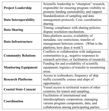
The literature on Science Diplomacy points to nine issue areas (Table 1.2) specific to
collaborative international scientific research that are especially relevant to Arctic observing:
Table 1.2 Issue Categories Impacting International Scientific Collaboration
Project Leadership
Scientific leadership to “champion” research; responsible for ensuring program visibility to promote funding sustainability and support.
Data Interoperability
Standardization of sampling and data management protocols. Cost; coordination; sharing.
Data Sharing Timing; compliance with sharing policies; dispute resolution mechanism.
Data Infrastructure
Data platform access; availability of metadata; size restrictions; transfer of management between centers. (What is the platform; how does it work?)
Community Relations
Conflicts or collaboration with indigenous communities (e.g., negative responses to research activities, or facilitation of research).
Monitoring Equipment
Funding for and availability of scientific equipment; logistics of transfer to monitoring areas.
Research Platforms
Access to icebreakers; frequency of ship traffic (scientific cruises and ships of opportunity).
Coastal State Consent Vessel access to territorial waters of other countries for transit and sampling.
Coordination
Facilitation of international and
interdisciplinary cooperation; managing various program components, data, and collaboration among participating parties.
“Science partnerships have been a fundamental part of Arctic exploration for centuries. Expanding the size and scope of these partnerships can bring benefits to the many nations that have interests in the Arctic. But it requires thoughtful reflection on the roadblocks to successful collaboration. What barriers exist to effective international partnerships in the Arctic? How can scientists and governments forge closer ties, and what lessons can successful collaborations provide? Answering these questions will shed light on important issues that will affect research in the High North for decades to come.”
– Eli Kintisch, Science & Diplomacy, AAAS (2015)
Many examples of successful long-term international scientific cooperation in the Arctic
exist in recent history, ranging from the formation of the International Council for the
Exploration of the Sea (ICES) by Russia, Germany, the United Kingdom and Scandinavian
nations in 1902, to today’s international cooperative oceanographic monitoring networks. In
1902, the ICES was established as a collaborative scientific initiative with the objective of
informing management of the Barents Sea cod fishery. The partnership met through the 1950s,
eventually leading cooperative multi-vessel surveys in 1965 that became known as the Barents
Sea Ecosystem Survey. This effort led to the 1976 implementation of the Joint Fisheries
Commission between Norway and the Soviet Union. The Tiksi International
Hydrometeorological Observatory project undertaken by Finland, Russia and the United States
led to the creation of vital Arctic observing stations that gather important atmospheric
measurements (e.g., methane flux from Arctic sources and changing properties of permafrost).
The Northeast Science Station (NESS) in Siberia represents one of Russia’s most successful
scientific organizations in the Arctic and hosts a number of foreign scientists each year to
collaborate on climate research (Kintisch, 2015). The Distributed Biological Observatory (DBO)
represents another case in which high-level, agency-to-agency cooperation surrounding Arctic
oceanographic data that can be used to steer environmental governance, regional strategy, and
ongoing scientific research efforts.
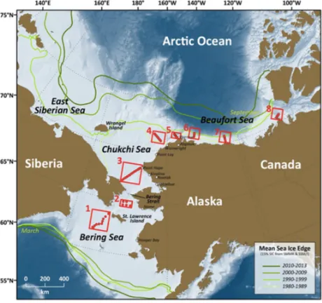
The DBO is a joint program between the United States, Russia, China, Japan, South
Korea and Canada to conduct multidisciplinary Arctic ocean sampling using 200 km-long
transect lines across key areas of marine productivity and biodiversity. The primary objective of
DBO is to “track biological responses to the changing physics evident in the Arctic” (DBO
Website, 2017). The DBO was originally envisioned as a “change detection array along a
latitudinal gradient” that would extend from the northern Bering Sea to the Barrow Arc in the
Northwest Pacific Ocean (Fig. 1.1). The Pacific Arctic Group (PAG), a consortium of
institutions and individuals with a Pacific perspective on Arctic science, originally coordinated
international participation (with US national participation managed by NOAA). The DBO
emerged as a result of a need to pool resources and standardize sampling protocols across
regions.
The DBO functions as a result of collaboration between multiple US federal agencies and
academic institutions, as well as from other Arctic nations (Fig. 1.3). Each of the six countries
participates in monitoring and sampling efforts using standardized physical, chemical and
biological measurement protocols along the established transects. Data gathered has informed the
publication of many scientific papers focused on change in global oceans. Sampling along the
various DBO sites does not rely solely on dedicated research cruises (which are often cost
prohibitive), allowing also for contribution of data from ships of opportunity. Due to budgetary
pressures, neither the US science agencies nor their partners would have been able to fund this
type of data collection without international collaboration and shared resources (Kintisch, 2015).
Currently, DBO interagency partnerships involve multiple groups within the National Science
Foundation, the Alaska Ocean Observing System (AOOS), the National Aeronautics and Space
Administration (NASA), the Bureau of Ocean Energy Management (BOEM), and the National
Oceanic and Atmospheric Administration (NOAA) (Fig. 1.2). Academic partners include Clark
University, Florida Institute of Technology (FIT), Old Dominion University (ODU), Oregon
State University (OSU), Stanford University, University of Alaska, Fairbanks (UAF), University
Corporation for Atmospheric Research (UCAR), University of Maryland Center for
Environmental Science (UMCES), University of Rhode Island (URI), University of Washington
Figure 1.2 DBO Interagency Partners. Government agency and academic partners collaborating in support of the DBO. Source: Distributed Biological Observatory: Implementation Plan, 2015-2024 (May 2016).
Figure 1.3 Pacific Arctic Group (PAG) Members. Pacific Arctic Group (PAG) international partners contributing to the sampling of the DBO. Source: Distributed Biological Observatory: Implementation Plan, 2015-2024 (May 2016).
The success of the Pacific DBO has led to plans for expansion to other parts of the Arctic
circumpolar system, including the Northeast, or European, Atlantic. Figure 1.4 provides a map of
planned transect sites for the Northeast Atlantic DBO, which would extend along a latitudinal
Figure 1.4 Northeast Atlantic DBO. Area of interest for expansion of the DBO into the Northeast Atlantic. Image provided by Marit Reigstad, UiT, Norway.
In addition to expansion to the Svalbard region, interest has arisen in establishing DBO sites in
the Baffin Bay area of the Northwest Atlantic. While planning for the Svalbard DBO site is
underway, the Baffin Bay expansion is still in its nascent stages.
Given the early stage of conception of a Baffin Bay area DBO, an opportunity exists to conduct
research focused on the specific interests, potential challenges, and opportunities surrounding
expansion to a new Arctic region. As noted by Kintisch (2015), while expanding the scope and
size of international scientific partnerships can maximize the benefits of Arctic research, it is
critical to consider carefully potential barriers to successful collaboration. It is the goal of this
paper to begin formulating an understanding of such barriers, as well as opportunities, that will
help facilitate future planning.
1.2 Research Questions
Objectives
The broader objectives of this research are:
1) To better understand stakeholder perspectives on key parties, issues, interests, challenges,
and opportunities related to expansion of a DBO into the Canadian Arctic, and
2) To provide recommendations to inform future expansion of the DBO.
Key research questions guiding this include the following:
1) Which stakeholders should be involved in a Baffin Bay area DBO?
2) What are the main issues related to DBO expansion to the Baffin Bay area?
3) What are stakeholders’ priority interests?
4) What potential barriers exist surrounding expansion?
5) What opportunities exist?
Research Design
The prospective Baffin Bay DBO represents a single case study within the broader
context of international scientific collaboration in Arctic observing. This research aims to
provide a comprehensive overview of stakeholder perspectives on expanding the DBO to the
Baffin Bay-Davis Strait area, which scientists and policy-makers can use for planning and
implementation. This research was conducted utilizing a Stakeholder Assessment approach,
which aims to identify key participants, their priority issues, their interests, and challenges and
opportunities related to expanding the DBO. Data was collected via semi-structured interviews
with key stakeholders who were identified based on: 1) current involvement with an existing
DBO, 2) likely interest in future DBO establishment (e.g., those affiliated with existing or
historical regional observing efforts near Baffin Bay) and, 3) recommendations from other
stakeholders (i.e., “snowball sampling”). Interviewees were recruited based on intent to represent
a range of stakeholder groups and perspectives, including academic research, government
(including federal and state agencies), policy and management, and local communities. Note: this
study did not involve direct interviewing of representatives from indigenous groups due to both
lack of established relationships and sensitivity to colonizing research approaches. Instead,
interviews were conducted with individuals who do have established relationships and
experience living in or working with communities. While imperfect, the intent was to avoid
short-term, extractive engagement, while highlighting the importance for DBO expansion
participants and indigenous communities to engage in longer-term, collaborative research. A
document review was also conducted and focused on the 2017 Agreement on Enhancing
International Arctic Scientific Cooperation in order to identify potential impacts on expansion of
This research was designed with the intent to provide relevant findings and
recommendations for other large, international scientific programs conducted in other regions –
both within the circumpolar system and in other areas. Specifically, the output of this research
hopes to inform future efforts within the scientific community to establish, develop, and expand
complex observing systems and associated data management networks. Part of this research
involved participating in the Working Group on Implementing and Optimizing a Pan-Arctic
Observing System at the 2018 Arctic Observing Summit in Davos, Switzerland. The overarching
goal of the Working Group was to identify or develop governance models that foster integration
of different observing platforms and activities into a cohesive framework that can be transferred
across disciplines and geographies. In addition to clear governance structures for Arctic
observing, the group also identified a need for: 1) consistent definitions of observing systems and
components (e.g., sensors, platform types, etc.) and, 2) determination of which types of resources
are necessary to fully operationalize observing efforts for a variety of essential variables. The
Working Group’s exploration of high-level structured approaches to Arctic observing also
focused on ways to create linkages across communities or research structures by attempting to
identify gaps between different components of observing systems in order to work toward a
“unified and adaptable” framework for Arctic observing. Several examples were developed
based on different research areas including sea ice, permafrost, and benthic community
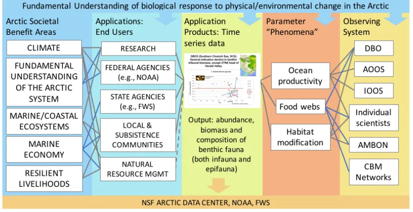
abundance. By developing conceptual maps of the societal drivers, system users,
products/output, focal phenomena, and associated observing systems; members of the Working
Group were able to begin looking for potential linkages between these different categories – and
explored during the summit: a systems map of observations of benthic invertebrate abundance
and distribution.
Figure 1.6 AOS 2018 Working Group 2 Systems Mapping Example. Benthic Invertebrate Abundance and Distribution. Developed and presented by Claire Eaton, University of New Hampshire, June 2018.
This need for more standardized and unified approaches to observing system development aims
to address a number of issues common among large-scale scientific research programs: issues
surrounding program redundancy (e.g., separate systems in the same region studying the same
phenomena without meaningful connection), standardization of protocols, lack of temporal and
spatial continuity across regional studies, limited data sharing across efforts, competition for
platform access, etc. The same types of issues impact observatories like the DBO; therefore,
these frameworks should be considered as part of a broader goal to increase connectivity
between research programs and to maximize access to resources (either by pooling or tightening
the scope of proposals). This paper, though specific to a certain form of observing system within
a specific geography, will attempt to identify and describe some mechanisms through which the
aforementioned issues may be addressed by efforts across disciplines in the Pan-Arctic. Because
system from the ground up that anticipates and is prepared for the different issue types (e.g., how
to effectively manage and share data across team members from different countries and/or
disciplines).
Geographic Focus
The focus of this research is a particular Arctic region, the Baffin Bay-Davis Strait area.
Issues and conditions specific to this geography – whether physical, environmental,
socioeconomic, or political – create a unique atmosphere in which international scientific
collaboration will occur.
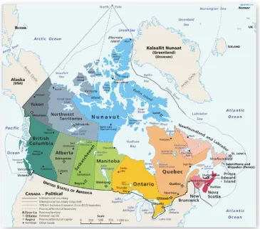
Baffin Bay and Davis Strait are two large ocean basins located between Baffin Island and
Greenland (Fig. 1.6). Spanning over 1.1 million square kilometers, these ocean basins connect
the Arctic Ocean with the Atlantic. High-volume southward flows of relatively freshwater, sea
ice, and glacial ice converge between Canada and Greenland, resulting in a notable outflow site
for Arctic waters. The regional climate is highly influenced by the Greenland Ice Sheet,
Canadian ice caps, and the Arctic ocean (BBOS Report, n.d.). The region is highly biologically
productive; particularly the North Water Polynya, which is one of the Arctic’s largest open-water
areas and a critical ecological hotspot. Polynya are geographically fixed areas of year-round open
water surrounded by sea ice that create important refuges for marine mammals and birds.
Polynyas also allow for earlier seasonal primary production in the spring (compared to
ice-covered areas). The North Water Polynya is of vital interest to Inuit hunters, given the abundance
of prey species (AMAP, 2017). Baffin Bay is home to globally important populations of
bowhead whales, narwhals, fish, seabirds, and cold water coral (Pew Charitable Trusts, 2017).
The Baffin Bay-Davis Strait region includes part of Nunavut, a territory in Canada and Western
Greenland. The majority of the population in this region is Inuit, with approximately 52,500
living in Greenland and close to 20,000 in Canada (AMAP, 2017). Both communities rely on
coastal zones of Baffin Bay for critical marine resources. On the Canadian side, coastal waters
provide hunting grounds and transportation corridors for local Inuit communities, as well as
subsistence fisheries of Arctic char and turbot. On the Greenlandic side, deep-water ports near
Disko Bay have established intensive fisheries. Commercial fishing in Baffin Bay consists
mainly of bottom-trawls for turbot (Greenlandic halibut) and shrimp. Management of the fishery
is through the North Atlantic Fisheries Organization and the Canadian government (Pew
long history of establishment in the area (for example, the Baffinland Iron Mine). The
Greenlandic government has issued a series of licenses for hydrocarbon extraction in recent
years (2002 – present) that include prospective reserve areas in Baffin Bay and Davis Strait
(BMP, 2016).
In addition to being a region of high ecological, economic, and political value; the Baffin
Bay-Davis Strait area is among the fastest-changing regions impacted by climate change.
Climate change will significantly increase the level of difficulty and uncertainty surrounding
regional decision-making in the Baffin Bay area, and Arctic stakeholders are facing unknown
probabilities (e.g., what the likelihood of an oil spill in the Arctic Ocean might be), as well as
unknown consequences (e.g., the resulting level of damage) (Young, 2012). As such, there is an
urgent and immediate need to balance human economic and social interests with environmental
conservation and natural resource management. Expansion of a DBO to the Baffin Bay-Davis
Strait region to observe physical and biological change in the region will be affected by a variety
of external factors unique to this specific geography; therefore, an opportunity exists to examine
the landscape in which scientific collaboration will occur in order to both plan for possible
roadblocks, as well as maximize the benefit potential of opportunities. This research uses a
Stakeholder Assessment approach to achieve this goal.
Stakeholder Assessment
Overview of Main Objectives
Stakeholder Assessment, also referred to as conflict assessment, stakeholder analysis or
situation assessment, is commonly identified as a necessary first step in a collaborative process
2008; Schenk, 2007). A stakeholder assessment is defined as an information-gathering exercise
that seeks to determine: 1) who has a stake in a given conflict or consensus-building effort; 2)
what issues are important to those stakeholders; 3) whether or not it makes sense to proceed in a
collaborative effort; and 4) the circumstances under which parties will agree to participate
(Susskind & Thomas-Larmer, 1999). The assessment process seeks to clarify issues surrounding
conflict framing and identification of different parties’ interests. Schenk (2007) notes that, while
some conflicts are easy to frame, with clear parties and interests, most are complex and
characterized by a high degree of uncertainty (i.e., uncertainty as to who the stakeholders are,
what their goals and objectives are, what the chances of an agreement are, etc.). While most
stakeholder assessments share similar core objectives, approaches to structure and process vary
among practitioners (and often depend on the appropriateness of different approaches to various
situations) (Schenk, 2007). Another – perhaps less well-known or underutilized – objective of
stakeholder assessments is to provide a reference point for evaluating progress (Bean et al.,
2007). Used in this way, an assessment can be reviewed periodically as a benchmark or
touchstone throughout a given process.
The application of stakeholder assessments to environmental and natural resource-based
conflicts has been explored by a variety of authors (Bean et al., 2007; Grimble & Wellard, 1997;
Reed, 2008). Environmental issues are notably complex and often characterized by a high degree
of uncertainty, typically involving actors and agencies at multiple scales (Reed, 2008). Reed
confirms that the quality of decisions (or other outcomes) generated as a result of stakeholder
participation is strongly dependent on the structure of the process leading up to them. Best
practices related to process design include: development of a foundational philosophy based on
process as possible; definition of clear objectives from the start of a process; designation of a
skilled facilitator; integration of local and scientific knowledge in order to provide a
comprehensive understanding of dynamic Earth systems; and institutionalization of stakeholder
participation as a part of organizational culture (Reed, 2008).
Elements of Process
The assessment process is designed based on recommendations surrounding which
groups should be involved in the process, goals for the process, issues to be discussed, a potential
work plan and timeframe, draft ground rules (e.g., addressing issues including how decisions are
made, or how parties will interact), and cost considerations (Schenk, 2007). One of the most
frequently referenced works on approaches to stakeholder assessments is Susskind &
Thomas-Larmer (1999) in the Conflict Resolution Handbook. Susskind and Thomas-Thomas-Larmer (1999)
outline a prescriptive method as follows:
1. The assessor is given a mandate to do the assessment;
2. Stakeholders are identified and interviewed according to set interview protocol;
3. Interview findings are analyzed;
4. The feasibility of a collaborative process is determined;
5. A process is designed based on the feasibility and possible paths forward;
6. A summary report is shared with stakeholders
This approach has been adapted by groups using stakeholder methodologies in fields related to
environment and natural resources, including the NOAA Office for Coastal Management (2007),
natural resource management. NOAA’s approach is based on the understanding that stakeholder
participation in natural resource management decisions provides a variety of benefits, including
the following:
• Improved outcomes or decisions
• Increased public support for agencies and their decisions
• Sharing of important local knowledge about natural resources
• Increased public understanding of natural resource issues or management
decisions
• Reduced conflict between stakeholders
• Ensured implementation of new programs or policies
• Increased compliance with natural resource laws and regulations
• Increased awareness among agencies of flaws in existing management strategies
• Creation of new relationships among stakeholders
This approach also identifies potential challenges that may arise as a result of stakeholder
participation, including prohibitive costs, time and labor requirements, decision-making delays,
escalation of conflict, or creation of new conflict (NOAA, 2007).
The definition of who is a stakeholder is typically flexible. NOAA’s Coastal Services
approach notes that practitioners of stakeholder methodologies often joke that the definition of a
stakeholder is “anybody who wants to be.” Generally, a stakeholder is someone who has an
interest in or is affected be a decision. Stakeholders also may have influence or power over a
situation. Interests may be economic, professional, personal, cultural – often stemming from a
variety of motivations (NOAA Coastal Services Center, 2007). Once interviews have been
what their interests and concerns are, and whether or not moving forward with a
consensus-building process is appropriate (or likely to succeed) (Susskind & Thomas-Larmer, 1999).
During the analysis phase, findings from interviews are summarized and areas of disagreement
and agreement are identified and mapped.
DBO Stakeholder Assessment Objectives
Broadly, the objectives of this research are to better understand stakeholder perspectives
on key parties, issues, interests, challenges, and opportunities related to expansion of a DBO; and
to develop a report that may later influence planning and implementation of regional efforts in
the Baffin Bay area. More specific tasks that this research aims to accomplish are as follows:
1) Identify which stakeholders should be involved with a Baffin Bay-Davis Strait
DBO,
2) Understand the main issues related to DBO expansion to the Baffin Bay area,
3) Understand what stakeholders’ interests are (and how they are prioritized),
4) Explore what potential opportunities exist.
This assessment may also provide a useful benchmark that can help project coordinators and
other stakeholders evaluate progress throughout the various stages of planning and
implementation. The results of this study could be used a reference or guiding document
throughout the different phases of the implementation process.
DBO Stakeholder Assessment Process
In order to achieve the previously outlined goals and objectives, this research will follow
1) Identification of stakeholder groups based on affiliation with key organizations
and recommendations from other stakeholders (snowball method),
2) Gathering of information via interviews and document analysis,
3) Qualitative analysis of data,
4) Development of recommendations for effective collaboration,
5) Distribution of summary report to stakeholders.
Data Collection
Interview Methods
Interviewees were recruited with the goal of hearing from a range of stakeholder groups
and perspectives, including academic research, government (federal and state agencies), policy
and management, and local communities. Stakeholders were identified based on: 1) current
involvement with an existing DBO, 2) likely interest in future DBO establishment (e.g., those
affiliated with existing or historical regional observing efforts near Baffin Bay) and, 3)
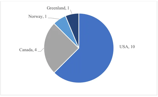
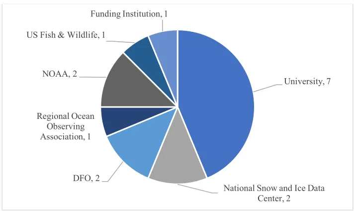
recommendations from other stakeholders (i.e., “snowball sampling”). In practice, a total of 16
semi-structured interviews were conducted, representing a range of nationalities, regional
geographies, stakeholder groups, roles, and organizational affiliation (Figs. 1.6, 1.7). A majority
of interviewees are based in the US due to the fact that the Pacific DBO was championed by a
group of US participants and, therefore, many of the individuals interested in expansion are part
of a US network. These individuals represent the cohort interested in driving forward the idea of
DBO expansion to the Baffin Bay area. Similarly, a majority of the interviewees are scientists, as
the DBO was originally conceptualized as a way for Arctic scientists to share resources and
by the interviewees and should not be considered representative of all stakeholders. Instead, the
findings aim to identify a broader range of stakeholders and organizations who should be
engaged in next steps for DBO expansion to the Baffin Bay area.
The interview protocol developed for this research was tested with an outside scientist
familiar with both oceanographic and social science methodologies in Arctic research
applications and revised based on their comments. Interviews were conducted between January
2018 and May 2018. Interviews were conducted over the phone and audio-recorded, lasting from
50-120 minutes. Interviews were transcribed and formatted for input into NVivo analytic
software.
Figure 1.8 Interview Participants by Country
USA, 10 Canada, 4
Norway, 1
Figure 1.9 Interview Participants by Organization
Document Review Methods
Data was also collected through review of the 2017 Agreement on Enhancing
International Scientific Cooperation, which is publicly accessible via the United States State
Department website. Review of the agreement helped to clarify the current political context in
which international scientific cooperation in Arctic research is conducted. Specific articles of the
agreement were reviewed and the various issues outlined therein (e.g., access to research areas,
access to data) were used to develop a framework of potential issues faced by researchers and
practitioners working in the Arctic.
Analysis Methods
Analysis of data gathered during interviews was guided by a codebook that was
developed using themes from the science diplomacy literature, as well as key issue areas outlined
by the Agreement on Enhancing International Scientific Cooperation and emergent themes
University, 7
National Snow and Ice Data Center, 2
DFO, 2 Regional Ocean
Observing Association, 1
NOAA, 2 US Fish & Wildlife, 1
identified during a preliminary analysis of transcripts. Inter-coder reliability tests were conducted
to confirm clarity. The codebook was shared with two other researchers to ensure codes were
clear, and that another researcher could come to a similar understanding of meaning or
definition. Selected transcripts were also shared with other researchers, which were then
independently coded. The coded transcripts were then compared and scored based on percentage
of agreement. Based on this exercise, codes and definitions of those codes were further refined to
ensure clarity, accuracy, and reproducibility. NVivo qualitative analysis software was used to
organize, compare, and query data. The results of those queries were then analyzed against
broader themes identified in the literature and organized based on the described categories
characteristic of a Stakeholder Assessment approach (i.e., issues, interests, barriers,
opportunities).
1.4 Thesis Outline
The following chapters in this paper are organized as follows. Chapter 2 presents findings
related to stakeholder groups, issues, barriers and interests. Chapter 3 describes opportunities for
consideration during future development of a Baffin Bay area DBO. Chapter 4 offers
CHAPTER 2: STAKEHOLDER GROUPS, INTERESTS, ISSUES & BARRIERS
2.1 Stakeholder Groups
This research deals with two different understandings of “stakeholder groups;” the first
referring to the individuals interviewed as part of this study, and the second encompassing the
various types of stakeholders identified by interviewees during the data gathering process. This
analysis is primarily concerned with the latter groups. By utilizing a node selection approach (see
Appendix D, Query Strategy), it was possible to compile an exhaustive list of stakeholder groups
identified by interviewees. The list could then be further refined based on categorical groups,
including Countries, Regional Groups and Non-Governmental Organizations (NGOs),
Government Agencies, Military, and Networks (see Tables 2.1-6). In addition, several broader
groups emerged from the data, including the scientific community, which can be further distilled
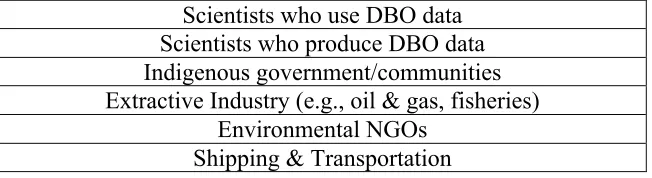
to scientists who use DBO data and scientists who produce DBO data. Other broad categories of
stakeholders identified are listed in Table 2.1. Often, inclusion of the scientific community in
interviewees’ listings of stakeholders was implicit, as the DBO as a form of research program is
perceived as being inherently based on collaboration between individual scientists.
Table 2.1 Stakeholders Identified by Interviewees to Engage in DBO Expansion to the Baffin Bay-Davis Strait Region: Broad Categories
Scientists who use DBO data Scientists who produce DBO data Indigenous government/communities Extractive Industry (e.g., oil & gas, fisheries)
Environmental NGOs Shipping & Transportation
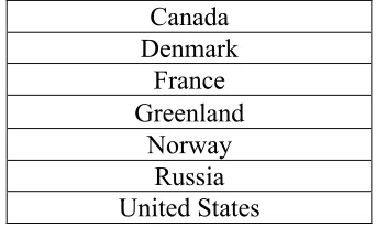
Typically, interviewees first identified the various countries (both Arctic and Sub-Arctic) that
Table 2.2 Stakeholder Identified by Interviewees to Engage in DBO Expansion to the Baffin Bay-Davis Strait Region: Countries
Canada Denmark
France Greenland
Norway Russia United States
Note: Stakeholders also identified “Nordic countries” broadly, which is understood as including primarily Norway and Sweden (based on interest in Arctic marine research and research platform availability).
Of the seven countries identified, Canada, Greenland, and the United States were indicated as
being the core nations that would likely lead any collaborative research effort in the Baffin
Bay-Davis Strait region. The majority of stakeholder groups identified at the sub-national scale can be
categorized based on these three national designations (see Tables 2.3-5). The following tables
represent potentially interested stakeholders that were identified by interviewees.
Table 2.3 Stakeholders Identified by Interviewees to Engage in DBO Expansion to the Baffin Bay-Davis Strait Region: Regional Groups & NGOs by Country
Indigenous Organizations
Inuit Knowledge Center
Regional Inuit research communities/centers Nunavut Research Institute
Qikiqtani Inuit Association (QIA)
Canada Oceans North WWF Canada
Greenland None identified
United States Defenders of Wildlife
Regional groups and NGOs were considered to be key stakeholders in Canada due to the
prevalence of indigenous research centers and other groups in the Baffin Bay area; however,
government centralization. In the United States, agencies were more often indicated as key
stakeholders, rather than regional groups and NGOs. Indigenous organizations such as the Inuit
Knowledge Center and Qikiqtani Inuit Organization (QIA) were referenced by many
interviewees who underscored the importance of early engagement of regional indigenous and
land claim groups located in the vicinity of Baffin Bay.
Table 2.4 Stakeholders Identified by Interviewees to Engage in DBO Expansion to the Baffin Bay-Davis Strait Region: Government Agencies by Country
Canada Fisheries & Oceans Canada (DFO) Transport Canada Bedford Institute of Oceanography (BIO)
Greenland Department of Natural Resources
United States
National Oceanic and Atmospheric Administration (NOAA)
US Fish & Wildlife Service (US FWS) Bureau of Ocean Energy Management (BOEM)
National Aeronautics and Space Administration (NASA)
Bureau of Safety and Environmental Enforcement (BSEE)
Office of Naval Research (ONR)
Varying degrees of government centralization may be evident in the agency stakeholder
lists, with Canada and Greenland having far fewer individual agencies referenced than the United
States. For the United States, the National Oceanic and Atmospheric Administration (NOAA)
was seen as a core player in a proposed Baffin Bay DBO, and it was projected that the Bureau of
Ocean Energy Management (BOEM) and Bureau of Safety and Environmental Enforcement
(BSEE) may be interested parties due to potential extractive industry opportunities in the greater
Baffin Bay area. The Office of Naval Research (ONR) was indicated as a potential source of
Table 2.5 Stakeholders Identified by Interviewees to Engage in DBO Expansion to the Baffin Bay-Davis Strait Region: Military Bodies by Country
Canada Canadian Coast Guard Royal Canadian Navy
Greenland Royal Danish Navy
United States
US Coast Guard
North American Ice Patrol (Homeland Security)
US Navy
Department of Defense Thule Air Base (Greenland)
Military institutions across the three core countries were seen as being important
“gatekeepers” in the sense that any marine research activities in areas of military interest or
exercise may require obtaining permissions prior to implementation. The US air base in Thule,
Greenland was indicated as one such institution that may require early communications
regarding expansion of an observing system near Greenland’s west coast, as were the Danish
Royal Navy and US Navy. In addition, it was suggested that opportunities may exist to share or
otherwise meaningfully connect (e.g., through access to data) existing military platforms and
infrastructure with future biological observing efforts. While the United States already heavily
relies on access to US Coast Guard platforms (i.e., icebreakers), interviewees wondered what
other monitoring programs could potentially dovetail with a DBO. For example, the North
American Ice Patrol is an international partnership between the Canadian Ice Service, the
International Ice Patrol, and the U.S. National Ice Center that monitors icebergs and sea ice
conditions for maritime safety applications. The Patrol is active in the vicinity of the Grand
Banks, Newfoundland and the east coast of Labrador, Canada. Further examination of the
Table 2.6 Stakeholders Identified by Interviewees to Engage in DBO Expansion to the Baffin Bay-Davis Strait Region: Networks
Arctic Frontiers (International)
International Ocean Observing Systems (IOOS) (International) St. Lawrence Sea Way (US-Canada)
ArcticNet (International)
Networks encompasses a number of identified stakeholders that represent regional and
international groups active in Arctic research and monitoring. International Ocean Observing
Systems (IOOS) and ArcticNet were among the most frequently cited, due to an obvious focus
on Arctic ocean research and long-term monitoring. ArcticNet is a Network of Centres of
Excellence of Canada, which collaborates with researchers in Denmark, Finland, France,
Greenland, Japan, Norway, Poland, Russia, Spain, Sweden, the United Kingdom, and the United
States, as well as with Northern and indigenous communities in Canada. The primary focus of
ArcticNet’s work is development of adaptation strategies and policies surrounding climate
change impacts. The St. Lawrence Seay Way is a co-managed maritime jurisdiction between the
United States and Canada that was indicated as a potential collaborator based on ship traffic
patterns and access to shared resources.
2.2 Stakeholder Interests
Five broad interests were identified based on interview data, which are described in the
sections below.
Scientific Inquiry Broaden Geographic Coverage
Maximize Shared Resources
Increased Program Connectivity
2.2.1 Scientific Inquiry
Scientific Inquiry refers to the specific knowledge, information, or research areas that
stakeholders consider to be important or interesting. This interest is sometimes referred to as
scientific “justification.” This interest can be broken down into two additional subcategories:
environmental vulnerabilities and human impacts. The former relates to environmental or
ecological aspects of Arctic systems that are particularly sensitive to physical change. The latter
refers to the impacts of human activities on Arctic ecosystems, or the landscape more broadly.
An example of human impacts is increased commercial shipping activity in Arctic waters. Most
interviewees indicated (either directly or indirectly) interest in scientific inquiry, with relatively
equal representation of both environmental vulnerabilities and human impacts.
2.2.2 Broaden Geographic Coverage
This interest refers to stakeholders’ desire to expand research activities across the
Pan-Arctic to increase geographic coverage of available datasets and create opportunities for
comparative analysis of regional dynamics. This interest was indicated by most interviewees, and
represented an area of prioritization.
2.2.3 Maximize Shared Resources
Maximizing shared resources refers to stakeholders’ interest in coordinating research
projects and/or approaches and developing shared sampling protocols. Additionally, this interest