INTRODUCTION
Following the year 1990 land properties sur-rounding cities, especially those located within metropolitan areas have become subject to strong pressure towards investment. The majority of agricultural land they encompass has been re-purposed for construction, i.e. housing, services, industry and communication. Such lands in the Wrocław district (WD) contain some of the most efficient and useful agricultural soil in Poland.
In accordance with article 14, section 1 of the Spatial Planning and Development Act (SPaDA) the purpose of land is determined through the use of the local spatial development plan (LSDP). However, since January 1, 2004, when the Spa-DA came into force, the LSDPs no longer apply in most Polish areas. The purpose of property locat -ed in such areas is determin-ed through municipal studies of the conditions and directions of spatial development (further referred to as “Studies”), since according to article 9, section 4 of the SPa -DA their provisions “are binding to municipal au -thorities in the process of formulating local plans.”
As of December 31, 2012 the areas in all 9 WD municipalities were regulated through Stud -ies enacted between 2004–2012, which served as a basis for a uniform and reliable method of deter-mining the purpose of land.
A detailed and precise analysis of the dis -trict’s land properties is currently impossible due to a lack of up-to-date and complete data on:
• the possibilities for increasing development density in areas with purposes established in the LSDP;
• the decisions regarding the location of public purpose investments and the established de-velopment conditions, issued in cases where no LSDP were available in accordance with article 50, section 1 and article 59, section 1 of the SpaDa.
Article 154 of the Act on real estate manage -ment, as well as the professional experience of property appraisers prove the fact that the alloca-tion of real estate has a direct impact on its value.
THE SPATIAL DEVELOPMENT OF UNDEVELOPED REAL ESTATE
IN THE WROCŁAW DISTRICT
Leszek Stanek1
1 Department of Spatial Economy, Wrocław University of Environmental and Life Sciences, Grunwaldzka 53
Str., 50-357 Wrocław, Poland, e-mail: [email protected]
Volume 17, Issue 4, Sept. 2016, pages 203–208
DOI: 10.12911/22998993/64551 Research Article
ABSTRACT
The aim of the article is to analyse the problem of spatial planning in the Wrocław district, especially regarding the evaluation of the purpose of land in municipal stud-ies of the conditions and directions of spatial development. The analysis of purpose is significant with respect to its impact on real estate value and the forming of the rela -tion between supply and demand on the market. The purpose of land designated for various types of development and construction is decided by local administration and municipal councils. This, however, does not ensure adherence to principles of sustain-able development, as showcased by summing up the methods of land allocation in the district. It has been determined that according to the status for the end of 2012, 34% of land in the Wrocław district has been developed for housing, 26% for services and 18% for economic activity.
Keywords: undeveloped real estate, land allocation, metropolitan area. Received: 2016.05.15
ANALYSIS OF LITERATURE
Unlike in large European countries such as Germany, France and Great Britain, spatial plan-ning in Poland at the level of the district is not obligatory and is thus non-existent.
Available case studies on the subject of the analyses of the correlates between the undevel-oped property market and land purpose most com-monly involve areas reduced to a number of sepa-rated municipalities [Zydroń, 2011]; [Kałmucka et al. 2012]. Other studies analyse property meant specifically for selected purposes [Siejka, 2011]; [Gawron, 2014], or provide general character -istics of lands being part of metropolitan areas [Bieda and Jasińska, 2010], [BRILAND Report, 2013]. One of the articles involves the lands in the district [Zydroń and Kaczmarek, 2012], yet con -tains only analyses of the changes in ownership and structures of use in relation to an evaluation of the proper use of agricultural land.
The above-mentioned studies make use of a limited scope of real estate market analyses and deal with the subject of the various types of pur-pose in a very simplified manner. At times they contain overgeneralised functional assumptions, e.g. regarding the qualification of areas meant for development [Zydroń, 2011], which is contrary to Polish legal regulations.
Other studies, e.g. The real estate market within the spatial development system by profes-sor Tadeusz Markowski provide a valid analysis of the problem in question yet study it on a larger scale and in a very general scope. They indicate the ideological propositions for purpose-driven actions towards improving spatial development but never delve into the details of practical prob-lems tackled in this article.
RESEARCH AREA AND METHODOLOGY
The research area encompasses the Wrocław district, with an area of 1118 km², populated in 2012 by 124,509 residents [Wrocław Statistical Office, 2016]. It includes 9 out of the 27 munici -palities of the Wrocław Metropolitan Area (WMA) established in resolution XLVIII/1622/2014 by the Lower-Silesian Regional Assembly on March 27, 2014 which approved the 2020 Lower Silesia Voivodeship Spatial Development Plan.
Due to their spatial order and landscape val -ues the district’s areas should be subject to
protec-tion. These high attributes are a result of adhering to principles of sustainable development, high soil valuation classes and highly efficient agricul -tural economy made possible, e.g. due to benefi -cial climate conditions.
The following data served as the basis for the analysis:
1. Municipal studies of the conditions and direc -tions of spatial development from the years 2004–2012;
2. Market transactions from the register of real estate prices and values retrieved from the Dis -trict Cadastre Office in Wrocław.
3. Cadastre data comprised of vector maps with marked borders; plots, sections, municipalities, land use and soil valuation classes along with building outlines.
Ad 1. Since not all of the district’s lands are subject to LSDPs, the analyses of purpose have been established on the basis of Studies enacted in all of its municipalities. More precise data has been attained through a vectorisation of the Stud-ies, conducted on the basis of background draw-ings scanned in a 1:100000 scale. The boundaries of allocation have been aligned with plot borders and sections. The maps have been fixed to record parcel borders located on the outskirts of each municipality. The outline vectorisation has been performed with an accuracy allowing to deter-mine the dominant functions for each plot. After fitting the map all the functional units of the Stud -ies have been vectorised, focusing on three land
purposes: agriculture (R), housing (M) and eco -nomic activity and services (AG, U, US).
Ad 2. The analysis of real estate prices and values has been conducted on the basis of a regis-ter made available by the District Cadastre Office in Wrocław, which included over 35,000 transac -tions from 2001 to March 2013. During the first stage all the items have been rearranged in a new transactions register. The process involved the merging of the elements of single transactions, with a calculation of the land areas–agricultural land, forest areas, developed area and other– pertaining to each transaction. The merging was achieved according to the following procedure:
• collecting all the elements which constitute the transaction, i.e. plots, plot shares, build-ings, building shares and premises;
• determining the land area for housing areas, developed agricultural areas, roads, agricul-tural areas, areas used in services and for other purposes for each transaction using entries in the remarks sections and an analysis of land purpose within plots;
• determining the purpose of land formulated in the LSDP using entries in the remarks sections.
The quantitative analyses involved real es-tate transactions which have been executed in the “free market” and “tender sale” modes.
Ad 3. Since the district authorities did not collect complete cadastre data regarding build-ings and premises the study’s subject matter had to be limited to an analysis of undeveloped land property trade.
The analysis of undeveloped property prices in the Wrocław district between 2001–2012 was based on a division of transactions with respect to land allocation. The transactions have been sepa-rated into a number of undeveloped land groups:
• agricultural land considered by the purchaser as agricultural land;
• agricultural land considered by the purchaser as transitional agricultural land;
• land meant for housing;
• land meant for economic activity and services. The lands in certain municipalities have also been divided into:
• land meant for homestead development;
• land meant for housing and services;
• land meant for recreation;
• land meant for landscape services.
The non-uniform manner of marking alloca-tion makes it difficult to summarise the area of lands and their potential, which has its influence on shaping real estate prices.
The process of marking the allocation of a transaction in the remarks section of the price register as well as an analysis of documents and graphs included in the Studies served the process of qualifying transactions to a given group. Prior to the classification, the real estate markers used by the operator of the price register have been verified using a vectorised Study and a numeric cadastral map.
A software application has been developed for the purpose of verification, which allowed the calculation and proper marking of the set of plots located within each of the Studies’ outlines. Each plot has been marked using the name of the Study outline it was part of as well as the percentage of its share within the outline.
Example: plot 022301_2.0005.599 has been marked as RZ91 ZL9. This means that it belongs in 91% to the RZ (green agricultural land) out -line and in 9% to the ZL (forest area) out-line. The Study markers have been assigned to every plot within the district’s municipalities.
SPATIAL ANALYSES
The variability of land prices, dependent on land purpose, between 2001 and 2012 has been analysed separately for each of the 9 municipali-ties based on a division to three purpose groups: 1. Agricultural land for crops (the unit price usu
-ally does not exceed 10 PLN per m²);
2. Agricultural land whose purpose is scheduled to change or land that is especially valuable (higher prices indicate other aims behind the purchase of the land than agriculture, e.g. us-ing the option of changus-ing the purposes estab-lished in the Studies or LSDP);
3. Land for economic activity.
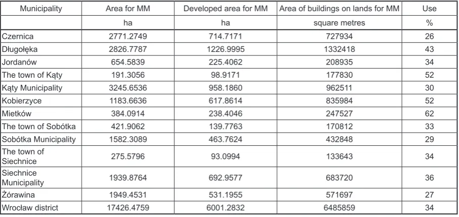
Table 1. Use of land for housing development purposes (MM).
Municipality Area for MM Developed area for MM Area of buildings on lands for MM Use
ha ha square metres %
Czernica 2771.2749 714.7171 727934 26
Długołęka 2826.7787 1226.9995 1332418 43
Jordanów 654.5839 225.4062 208935 34
The town of Kąty 191.3056 98.9171 177830 52
Kąty Municipality 3245.6536 958.1860 962511 30
Kobierzyce 1183.6636 617.8614 835984 52
Mietków 384.0914 238.4046 247527 62
The town of Sobótka 421.9062 139.7763 170812 33
Sobótka Municipality 1582.3089 463.7624 432848 29
The town of
Siechnice 275.5796 93.0994 133643 34
Siechnice
Municipality 1939.8764 692.9577 683720 36
Żórawina 1949.4531 531.1955 571697 27
Wrocław district 17426.4759 6001.2832 6485859 34
Price_K = Price_tr – Price_sr + Price_sr_K
where: Price_K is the updated price of the land for December 31, 2012;
Price_tr is the current price of the land on the day of the transaction;
Price_sr is the average price of the land
on the day of the transaction;
Price_sr_K is the average price of the
land from all transactions calculated for December 31, 2012.
The updated transaction prices have been as-signed to record parcels in all sections and for all municipalities. These were used to establish transaction price distribution maps with the divi-sion to allocation zones for crops and agricultural land meant for non-agricultural purposes, hous-ing development and economic activity.
On the scale of the Wrocław district these maps for the purposes in question have been represented in a study entitled An analysis of
the real estate market in the Wrocław district
[Lasota and Stanek, 2013].
RESULTS OF THE STUDY
The legal sovereignty granted to municipali-ties in the domain of spatial development has led to a poorly controlled, exploitative management of space. The analysis [Lasota and Stanek, 2013] shows a case of 9 Studies for the WD municipali -ties where there has been an increase in the total area meant for the purposes of a variety of
de-velopment types that was disproportionate to the actual needs.
• 17426.4759 ha of land has been designated for single-family housing, 6001.2832 ha of which (34.4 %) has already been developed. Assum -ing that a house meant for 4 persons can be founded on a plot of an area of 700 m², it is possible to create a total of 163,217 buildings on the non-developed lands designated for housing, which would provide residence to 652,868 people, which is more than the num -ber of currently registered permanent residents in Wrocław (633,802 people).
• 9195.4563 ha has been designated for busi -ness activity, 18% of which has already been developed.
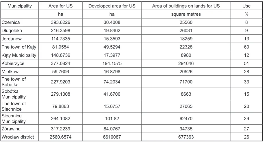
• 2560.6574 ha has been designated for servic -es, with 26% already developed in 2013.
The current Studies have been enacted for the Wrocław district between 2005–2012. In some sections the transactions from 2001–2012 have been settled on the basis of prior land allocation. Some of these transactions, especially those with agricultural land prices significantly divergent from average values, have most likely been per-formed using Studies which the seller and the pur-chaser had access to, but which have not yet been enacted. Proper land economy and reliable land evaluation requires the district’s County Office to have access to vectorised local plans or Studies.
standardisation and uniformisation. This can be achieved by enforcing the manner of land marking provided in appendix 1 of the regula-tion by the Minister of Infrastructure from the Dz.U.2003.164.1587 (Journal of Laws). This solution is currently not provided for by the regulation of the Minister of Infrastructure from Dz.U.2004.118.1233. The problem of uniformis -ing Study markers is also avoided in the 2020 Lower Silesia Voivodeship Spatial Development Plan, even in the delineated WMA area.
The accuracy of analytical calculations would be improved by altering article 5, section 1 of the regulation by the Minister of Infrastructure from Dz.U.2004.118.1233, so that it would establish the option of executing the Study using a modi-fied copy of the master map instead of a copy of the topographic map. This would additionally al-low to more precisely determine the congruence of the LSDP with the provisions of the Study, de -scribed in article 14, section 5 of the Act on spa -tial planning and development.
Table 2. Use of land for economic activity purposes (AG).
Municipality Area for AG Developed area for AG Area of buildings on lands for AG Use
ha ha square metres %
Czernica 771.6289 57.9696 40886 8
Długołęka 1473.7276 295.7648 368584 20
Jordanów 351.3302 59.1189 35555 17
The town of Kąty 304.6299 87.3845 138962 29
Kąty Municipality 1772.8232 262.4614 223375 15
Kobierzyce 2201.8642 498.5000 991807 23
Mietków 188.7802 37.5644 23033 20
The town of
Sobótka 160.2655 99.4477 38834 62
Sobótka
Municipality 586.2875 26.8802 32895 5
The town of
Siechnice 266.4809 134.4463 118080 50
Siechnice
Municipality 749.2264 53.7783 78549 7
Żórawina 368.4118 34.2641 61882 9
Wrocław district 9195.4563 1647.5802 2152442 18
Table 3. Use of land for services (US).
Municipality Area for US Developed area for US Area of buildings on lands for US Use
ha ha square metres %
Czernica 393.6226 30.4008 25560 8
Długołęka 216.3598 19.8402 26031 9
Jordanów 114.7335 15.3593 18259 13
The town of Kąty 81.9554 49.5294 22328 60
Kąty Municipality 148.8736 17.3977 8980 12
Kobierzyce 377.0824 194.1575 291046 51
Mietków 59.7606 16.8798 20526 28
The town of
Sobótka 227.9203 74.2034 71700 33
Sobótka
Municipality 279.1308 41.6706 8663 15
The town of
Siechnice 79.8863 15.6757 27065 20
Siechnice
Municipality 264.1082 101.82 62470 39
Żórawina 317.2239 84.0767 94735 27
CONCLUSIONS
The analysis of the register of real estate prices and values indicated that the registers are kept in accordance with the currently enforced regulation on registering land and property. Un-fortunately, the land allocations from the LSDP or the Studies, applying at the time of the transaction are not registered for each transaction. Adhering to the requirement of registering land allocation will make future analyses of transaction prices in each area easier without the need for additional corrections. Study guidelines can be added to the cadaster in a form of additional data for each record parcel, along with full data regarding the components of the real estate.
Analyses of municipal and district land trade can be automated once the prices and value reg-ister has been verified or once representative real estate has been selected. After establishing the complete registration of buildings and premises the analytical process can be broadened by the addition of premise and building trade analyses. Currently, such analyses would be subject to sim-plification and would prove hardly useful for mu -nicipal authorities and property appraisers.
The analysis indicated the need to introduce corrections to cadastral maps, as plot borders and land outlines include unassigned enclaves which make it difficult to perform spatial analyses and precisely determine land purpose.
REFERENCES
1. Bieda A., Jasińska E. 2010. An analysis of the real estate market in former rural areas using the example of the Kraków agglomeration (in Pol -ich). Infrastruktura i ekologia terenów wiejskich – The infrastructure and ecology of rural areas, 12, 5–15.
2. Gawron H. 2014. The development of urban ag-glomerations and their significance for the devel -opment of the local real estate market (in Polich). Zarządzanie i Finanse – Management and Financ -es, 12(4).
3. Kałmucka W., Kałmucki K., Kamińska A. & Fili -pek A. 2012. The changes in land use in Lublin and its closest vicinity in the last 40 years (in Polich). Barometr Regionalny – Regional Barometer, 4(30). 4. Markowski T.. 2015. Rynek nieruchomości w systemie planowania przestrzennego (The real
estate market in the spatial planning system). Do -radca Rynku Nieruchomości – Real Estate Market Adviser, 2.
5. BRILAND Report 2013. An analysis of the prices of land and the investment potential in the Warsaw metropolis (in Polich). BRILAND, Warsaw, Al. Je -rozolimskie 96 Str.
6. Siejka M. 2011. An analysis of the agricultural real estate market using the example of the rural areas of the Kraków district municipalities (in Pol -ich). Infrastruktura i ekologia terenów wiejskich – The infrastructure and ecology of rural areas, 3, 265–273.
7. Zydroń A. 2011. An analysis of the undeveloped real estate market in the selected municipalities of the Greater Poland region (in Polich). Rocznik Ochrona Środowiska – Environmental Protection Yearly, 13, 2033–2048.
8. Zydroń A., Kaczmarek J. 2012. An evaluation of the structural changes in the use and ownership of land in the years 2003–2010 in municipalities of the Środa Śląska district (in Polich). Nauka Przy -roda Technologie – Science Nature Technologies. Poznań University of Life Sciences, 6/2, 1–12. 9. Lasota T., Stanek L. 2013. An analysis of the real
estate market in the Wrocław district (in Polich). http://www.wrosip.pl/dokumenty/Analiza%20 rynku%20nieruchomo%C5%9Bci%20w%20Pow -iecie%20Wroc%C5%82awskim.pdf .
10. Act from March 27, 2003 on spatial planning and development (consolidated text, Dz.U.2015.199 as amended).
11. Act from August 21, 1997 on real estate economy (consolidated text, Dz.U.2015.1774 as amended). 12. Regulation by the Minister of Regional Develop
-ment and Construction from March 29, 2001 re -garding land and property registration (consolidat -ed text, Dz.U.2015.542).
13. Regulation by the Minister of Infrastructure from August 26, 2003 regarding the required scop of the local spatial development plan project (Dz.U.2003.164.1587), p. 6–7.
14. Regulation by the Minister of Infrastructure from April 28, 2004 regarding the scope of the munici -pal conditions and directions of spatial develop-ment project (Dz.U.2004.118.1233).
15. (2012). The Wrocław District Development Strate -gy for 2012–2020. (retrieved on May 1, 2016) http:// powiatwroclawski.ibip.wroc.pl/public/?id=98046. 16. Wrocław Statistical Office (data retrieved on Feb
-ruary 29, 2016).
![Figure 1. Map of the Wrocław district [The Wrocław District Development Strategy, 2012].](https://thumb-us.123doks.com/thumbv2/123dok_us/8371329.1675276/2.595.306.526.65.287/figure-map-wroclaw-district-wroclaw-district-development-strategy.webp)