University of New Orleans University of New Orleans
ScholarWorks@UNO
ScholarWorks@UNO
University of New Orleans Theses and
Dissertations Dissertations and Theses
Spring 5-18-2012
Transitional Facies and Sequence Stratigraphic Complexity of
Transitional Facies and Sequence Stratigraphic Complexity of
Shallow-Marine Star Point Formation to Coastal-Plain Blackhawk
Shallow-Marine Star Point Formation to Coastal-Plain Blackhawk
Formation Along Depositional-Strike, Wasatch Plateau, Utah
Formation Along Depositional-Strike, Wasatch Plateau, Utah
Andrew M. Ranson
University of New Orleans, [email protected]
Follow this and additional works at: https://scholarworks.uno.edu/td
Part of the Geology Commons, Sedimentology Commons, and the Stratigraphy Commons
Recommended Citation Recommended Citation
Ranson, Andrew M., "Transitional Facies and Sequence Stratigraphic Complexity of Shallow-Marine Star Point Formation to Coastal-Plain Blackhawk Formation Along Depositional-Strike, Wasatch Plateau, Utah" (2012). University of New Orleans Theses and Dissertations. 1476.
https://scholarworks.uno.edu/td/1476
This Thesis is protected by copyright and/or related rights. It has been brought to you by ScholarWorks@UNO with permission from the rights-holder(s). You are free to use this Thesis in any way that is permitted by the copyright and related rights legislation that applies to your use. For other uses you need to obtain permission from the rights-holder(s) directly, unless additional rights are indicated by a Creative Commons license in the record and/or on the work itself.
Transitional Facies and Sequence Stratigraphic Complexity of
Shallow-Marine Star Point Formation to Coastal-Plain Blackhawk Formation
Along Depositional-Strike, Wasatch Plateau, Utah
A Thesis
Submitted to the Graduate Faculty of the
University of New Orleans
In partial fulfillment of the
Requirements for the degree of
Master of Science
In
Earth and Environmental Sciences
Geology
By
Andrew Ranson
B.S. University of New Orleans, 2010
ii
Acknowledgements
I would like to thank my thesis advisor, Dr. M. Royhan Gani, who gave me this opportunity and
mentored me throughout this process. He has taught me beyond what I expected and has set me up for a promising career in the oil and gas industry. I would like to thank the American Chemical Society, American Association of Petroleum Geologist, and Chevron for their support and funding my thesis. Thanks are due to Dr. Gary Hampson of Imperial College of London, for his constructive and insightful reviews and discussions on this topic. I would also like to thank committee members, Dr. Mark Kulp and Dr. Nahid Gani for their commitment to my thesis. I would also acknowledge lab-mates, Hiranya Sahoo and Prabhat Neupane, for teaching me about different cultures of the world and for their
iii
Table of Contents
List of Figures ... iv
List of Tables ... v
Abstract ... vi
Introduction ... 1
Regional Geology and Study Area ... 4
Methods and Dataset ... 7
Results ... 9
Facies Association ... 9
Overall Depositional Pattern ... 16
Sequence Stratigraphic Framework ... 20
Backwater Effect ... 22
Discussion ... 25
Transitional Complexity ... 25
Strike Variability of the Sequence Stratigraphy ... 25
Paleogeography ... 27
Backwater vs. Seal-Level Drop ... 29
Conclusion ... 30
References ... 32
Appendix ... 38
iv
List of Figures
Figure 1: Locations of study area, stratigraphic column, and ... 2
Figure 2: Paleogeography of study area during the Campanian ... 4
Figure 3: Facies photographs ... 15
Figure 4: Lithologs of key study locations ... 17
Figure 5: Trail Mountain Mine’s facies architecture ... 18
Figure 6: Wattis Road’s facies architecture ... 19
Figure 7: Sequence stratigraphic correlation panel ... 21
Figure 8: Backwater effect ... 23
v
List of Tables
vi
ABSTRACT
Facies and stratigraphic architecture right at the transition from marine to non-marine environments is poorly documented. In the Cretaceous outcrops of Utah, Star Point and Blackhawk Formations are well studied. The nature of spatio-temporal transition of these two Formations, in the deposition-strike orientation, remains undocumented. This study characterizes facies and stratigraphic complexity at the transition of the two Formations that crop out in depositional-strike orientation in the Wasatch Plateau. Data from outcrop including photomosiacs and measured sections demonstrate this complexity at a range of scales. The Star Point constitutes a shoreface environment. The Blackhawk constitutes a coastal-fluvial environment.
In the northern part of study area, the transition from marine to continental strata is expressed by intertonguing succession. The dip-oriented outcrops show pinch-outs of two parasequences into coastal-plain deposits. This complexity decreases southward, the southern outcrops show a simple transition. At least two sequence boundaries are correlated across the outcrop belt.
1
INTRODUCTION
In the stratigraphic record, transition of shallow-marine to coastal plain depositional environment is generally thought of as a smooth transition without much complexity. Usually it is described as a gradual upward transition from marine to non-marine settings with a small number of sub-environments. However, by focusing on the sub-environments in the marginal-marine strata, this study set out to document that this transition from shallow marine to coastal plain can be rather very complex stratigraphically.
In the Wasatch Plateau (Fig. 1A), Utah, upward transition of the Cretaceous shallow-marine Star Point Formation to coastal-plain Blackhawk Formation has been poorly documented, compared to the neighboring Book Cilffs. This study investigates the complex intertonguing of the coastal plain and shallow-marine environments in outcrops along the north-eastern Wasatch Plateau.
2
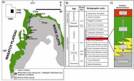
Figure 1: The present study focuses on the north-eastern Wasatch Plateau (A), contagious with the famous Book Cliffs. Note the locations of the studied outcrop “windows”. The studied interval is the transition of the Star Point Formation into the Blackhawk Formation (red box in B). This interval is described by the intertonguing of the marine Star Point Sandstones with the non-marine Blackhawk Formation (C). (modified from Hampson et al., 2011)
Fluvial incision eroding top of marine sandbody may not always be the result of a sea level fall. In one particular outcrop, a fluvial incision into a upper marine sandstone is likely the result of a backwater effect (Chow, 1959; Parker, 2008). The backwater effect is a hydrodynamic event that is seen in modern environments, such as the Mississippi River (Nittrouer et. al, 2011). The backwater effect can create multiple incisions, and give a false sense of a drop in sea level in the rock record. However, there has been no documented backwater effect in the rock record to date. The example presented here could be the first recorded event in the outcrop.
3
4
Regional Geology and Study Area
During the late Cretaceous, central North America was covered by a north-south trending, epicontinental sea knows as the Western Interior Seaway (Kauffman and Caldwell, 1993). The modern Wasatch Plateau, of eastern Utah was located parallel to the western coastline of the Interior Seaway during the Campanian Age (Fig. 2), thus preserving the sedimentary strata along depositional strike. The eight study sites (outcrop “windows”), are located in the north-eastern half of the Wasatch Plateau (Fig. 1A).
Figure 2: Cretaceous paleogeography of the Western Interior Seaway during the Campanian Age (~80 Ma ago). During this time the Star Point and Blackhawk Formations were deposited in a retro-arc foreland basin. Deltas and barriers islands were forming along the western shoreline and were sourced from the Sevier Orogenic belt
5
The studied late Cretaceous succession focuses on the transition of the upper Star Point and lower Blackhawk Formations, both of which belongs to the Mesaverde Group (Young, 1955; Cole et al., 1997). The Mesaverde Group was deposited in the seaway, as its shoreline repeatedly advanced and retreated resulting in a complex intertonguing of marine and non-marine strata (Henry and Finn, 2009). These deposits were sourced from the uplifted Sevier Orogeny to the west (Willis, 2000; Kaufmann and Caldwell, 1993). Rocks within the Wasatch Plateau normally have a dip of about two degrees to the northwest (Lamarre and Burns, 1997). Canyons were carved into the Wasatch Plateau as a result of erosion, exposing the Mesaverde Group and providing excellent windows outcrop options within the strata of our research.
The Star Point sandstone tongues (Fig. 1B), which have been interpreted to contain a number of parasequences (Hampson et al., 2011; Dubiel et al., 2000; Holman, 2001), overlie and intertongue the offshore deposits of the Machos Shale (Clark, 1928; Spieker, 1931). The Star Point Sandstone mostly consists of five parasequences that are predominantly linear to moderately lobate, wave dominated shorelines that define an overall concave-landward shoreline trajectory. Two of the five parasequences contain strong lobate river-dominated delta-front deposits that locally occur (Hampson et al., 2011). The majority of the Star Point sand bodies are overlaid by extensive coal zones of the Lower Blackhawk Formation. The coal flora indicates a climate of warm temperate to subtropical (Parker, 1976).
6
7
Methodology and Dataset
The Mesaverde Group crops out continuously along the eastern edge of the Wasatch Plateau for a distance of 100 kilometers (Hampson, 2011). The north-eastern portion of the Wasatch Plateau’s cliff face is sub parallel to the regional depositonal strike of the western paleo-shoreline of the seaway (Flores et al., 1984; Dubiel et al., 2000; Hampson et al., 2011). A series of canyons cut into the outcrop belts of the Mesaverde Group in this portion of the Wasatch Plateau. Eight of these canyons served as ideal study locations to capture the complexity of the transitional zone of the Star Point and the
Blackhawk Formation at a range of scales (facies, outcrop and regional). The sandstone exposures have mostly high visibility along the outcrop belt. However, the dominating mudstones tend to be covered by scree, which may be vegetated. In panoramic it is generally easy to distinguish the scree covered
mudstone strata compared to the more resilient sandstone architecture.
In this study, detailed lithologs were measured at all eight outcrop “windows” through the top of the Star Point and the overlying lower Blackhawk Formations. These lithologs contain bed thicknesses, sedimentary structures, grain size variations, ichnology, bioturbation index, and
8
9
RESULTS
Facies Associations and Depositional Environments
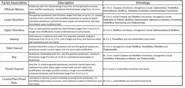
Eight facies associations, each representing a particular sub-environment of deposition, were recognized at the Wasatch Plateau outcrops. The identified facies associations are offshore marine, lower shoreface, upper shoreface, fluvial channel, tidal channel, swamp, coastal/flood plain, and bay that are summarized in Table 1. In combination, these associations are interpreted to represent two major depositional settings, marginal-marine and terrestrial coastal plain. By studying various sub-environments of the marginal-marine strata in the Wasatch Plateau, this study reveals that the transition from shallow marine to coastal plain can be rather very complex. Importantly, this
intertonguing transition contains incised channels, sequence boundaries, and abrupt, up-dip pinch outs of shallow-marine sandbodies (i.e. parasequences) into coastal plain mudstones, something that can serve as an analog for a lesser-known type of stratigraphic hydrocarbon trap.
Offshore Marine Facies Association (Fig. 3-A): These deposits consist mainly of mudstones with interbeds of very fine- to fine-grained, hummocky cross-stratified sandstones. The sandstone bed thickness ranges from 10 cm to 50 cm. A lower unit with Cruziana ichnofacies and a BI ranging from 3 to 5 was identified. The ichnogenera includes Siphonichnus, Terebellina, and Helminthopsis. An upper unit of mixed Cruziana and Skolithos ichnofacies with a BI ranging from 3 to 5 was identified. The
10
11
This facies association is interpreted to indicate an offshore marine environment, with a shallowing-upward trend. The majority of the deposits being mudstones with Cruziana ichnofacies indicate relatively low-energy conditions that are consistent with offshore marine environments below fair-weather wave base (Dott and Bourgeois, 1982). The hummocky cross-stratified sandstone beds indicate occasional storm events (Dott and Bourgeois, 1982). Storm beds are common in the offshore marine environments because strong storms have the ability to carry some of the shoreface sands to offshore and deposit them (Hamblin and Walker, 1979).
Lower Shoreface Facies Association (Fig. 3-B): These strata consist almost entirely of fine-grained sandstone beds with thickness ranging from a few cm up to 1 m. There is an upward-transition from hummocky cross-stratified sandstones to swaley to planar-laminated sandstones. Wave-ripples are preserved at some bed tops. Bioturbated, wavy mudstone beds were observed locally . A mixed
Cruziana and Skolithos ichnofacies with a BI ranging from 3 to 4 were identified. The ichnogenera include Palaeophycus heberti, Skolithos, Ophiomorpha, Paleophycus tubularis, Chrondrites, Terebellina, Asterosoma, and Thalassinoides.
12
marine environment above fair-weather wave base. The mixed Cruziana and Skolithos ichnofacies also indicate a lower shoreface environment (Pemberton et al., 1992).
Upper Shoreface Facies Association (Fig. 3-C): This facies association consists mostly of fine- to lower coarse-grained sandstone beds, ranging in thicknesses from 5 cm to 3 m. Dominant
sedimentary structure is trough cross-stratification, mostly unidirectional but some are bipolar. Primary paleocurrent directions of these dunes range from 72 to 93 degrees. A Skolithos ichnofacies with a BI ranging from 0 to 3 is identified. The ichnogenera includes Ophiomorpha and Skolithos.
Based on sedimentary structures and trace fossil assemblage, this environment is interpreted as an upper shoreface. Paleocurrents of the dunes probably indicate that, locally, dominant longshore current was towards the northeast. The coarser grain size of the sandstones and the lack of mudstones indicate a very high energy environment seaward and closer to the beach (Harms et al., 1975). The
Skolithos ichnofacies and the low BI also indicate a very high energy environment such as an upper shoreface (Gani et al., 2008).
13
This succession is interpreted as tidal channel deposits. The inclined heterolithic strata indicate a migrating tidal channel (Thomas et al., 1987), where mudstones were deposited during times of no tidal change (i.e. slackwater periods) and the sandstones were deposited when the tides were moving in and out. Double mud drapes also suggest a tidal influence in the environment. Moreover, presence of marine trace fossils indicates that the channel was influenced by marine processes.
Bay Facies Association (Fig. 3-E): These deposits consist of mostly mudstones interbedded with thin, very fine-grained sandstone beds with erosional bases. Symmetrical wave-ripples are present in the sandstone beds, which range in thickness from a few cm to 30 cm. A mixed Cruziana and Skolithos
ichnofacies with a BI ranging from 0 to 4 was observed. The ichnogenera includes Terebellina, Palaeophycus heberti, and Thalassinoides.
Restricted trace-fossil suite with non-uniform trend of BI log (Gani et al., 2008), and the presence of wave ripples but the lack of hummocky cross-stratification indicate a relatively shallow and protected marine environment such as a bay environment (Coleman, 1966; Dalrymple et al., 1992). Predominance of mudstones suggests a relatively low energy environment. However, the presence of thin, erosional sandstone beds with wave ripples indicates occasional stronger wave conditions affecting the bay floor.
14
coals are bright and shiny, and easily fractured. Some leaf impressions and root traces are present. The BI ranges from 0-1. Some Teredolities and rare vertebrate burrows are present locally in the coal beds.
This facies association is interpreted to deposit in swamps. Carbonaceous mudstones and coals are indicator of massive amounts of vegetation growth, which are commonly present in swampy environments near the coasts (Cobb and Cecil, 1993).
Coastal Plain / Flood Plain Facies Association (Fig. 3-G & 3-H): This facies association consists primarily of mudstone and siltstone deposits with subordinate, thinly bedded sandstones. Locally, the mudstone and siltstone deposits can contain carbonaceous material and palaeosols.. The deposits are rarely bioturbated with unidentifiable organism. Paleosols were identified at the Rilda Canyon outcrop with a thickness of up to 5.9 m. The massive appearing palaesol deposit lacks any facies structures and reacted with hydrochloric acid.
This succession indicates a coastal/flood plain deposits, based on the fact that paleosols and encase fluvial channel sandstones. The carbonaceous material is interpreted as vegetation growth on the floodplain. The mature calcareous palaeosols represent a major hiatus in deposition (Sheldon and Tabor, 2009).
15
dipping roughly 90 degrees away from the dips of the dune-scale cross-bedding. There are no identifiable burrows in this facies association, therefore, the overall BI is 0.
16
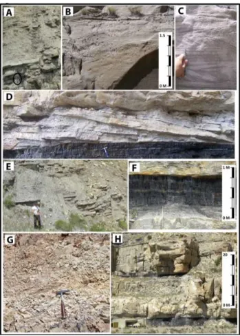
Figure 3: Representative facies photos of the Star Point and Blackhawk Formations in the north-eastern Wasatch Plateau. A) Offshore mudstones with thin bedded hummocky cross strata of the Star Point Formation (hammer
is circled for scale). B) Lower shoreface deposits with hummocky and swaley cross strata. Note the intense Ophiomorphitric burrowing. C) Dune cross-stratification of the upper shoreface deposits. Note the lack of trace fossils locally. D) Inclined heterolithic strata interpreted as a tidal channel deposit that are sandwiched between a coal seam (lower) and a erosionally-based (interpreted as incised valley) fluvial channel deposit (upper). E) Alternating layers of carbonaceous mudstones and sandstones with wave ripples that are interpreted to deposit
in bay environments. A coal seam caps this bay succession. F) Coal seams and carbonaceous mudstones, representing a swamp environment. G) Paleosol developed within flood plain mudstones. H) A pair of fluvial
17
Overall Depositional Pattern
18
Figure 4: A) The Trail Mountain Mine litholog illustrating a smooth and gradual upward transition from marine to non-marine strata. B) The Wattis Road Litholog documenting a rather complex upward transition from marine to non-marine strata. C) General legend for litholog, facies architecture, correlation panel, and diagrams
18
19
20
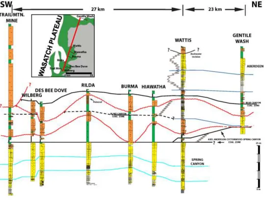
The transitional complexity decreases toward the south from the Wattis Road outcrop, but the fluvial complexity increases. The southern part of the study area contains more complex fluvial architecture: multi-story channels and channel belt complexes. At the Burma, Des Bee Dove Mine, Wilberg, and Trail Mountain Mine, fluvial channels appear to be incising into the surrounding coastal plain strata and depositing a multi-story incised valley fill (Fig. 7).
Sequence Stratigraphic Framework
The sequence stratigraphic framework of the Star Point and Blackhawk Formations is emphasizing different bounding surfaces (Fig. 7). For the Star Point Formation that is dominated with marine facies, marine flooding surfaces were used to identify sequence stratigraphic units like
parasequences. Inside parasequences, a lower order surface known as intra-parasequence minor flooding surface (Hampson, 2000), can be identified (Fig. 7). These surfaces were picked based upon the subtle yet abrupt fining of marine sandstones across these surfaces within an overall coarsening upward trend.
The Blackhawk Formation, being terrestrial in nature, is relatively challenging for establishing a sequence stratigraphic framework. Here particular attention was paid to distinguish incised-valley fills from regular channel deposits, identify paleosols, and correlate coal layers. Incisal bases of the thick and complex multi-storey sandbodies are interpreted as incised valley floors at several stratigraphic
21
22
Incised valley fills have been interpreted in the lower Blackhawk Formation based on the criteria of Zaitlin et al. (1994). Four important features have been indentified in this regard: (1) there are deep and widespread incisions at the base of these channelized deposits; (2) the multi-storey channel fill thickens laterally upward, indicating an upward increase in accommodation space; (3) the multi-storey channelized sandbodies are far larger than neighboring channelized sandbodies outside of the valley; (4) the interfluves contain well-developed mature paleosols. The floors of these incised valleys, along with their correlative interfluve surfaces, represent sequence boundaries generated dut to relative sea-level fall.
Backwater Effect
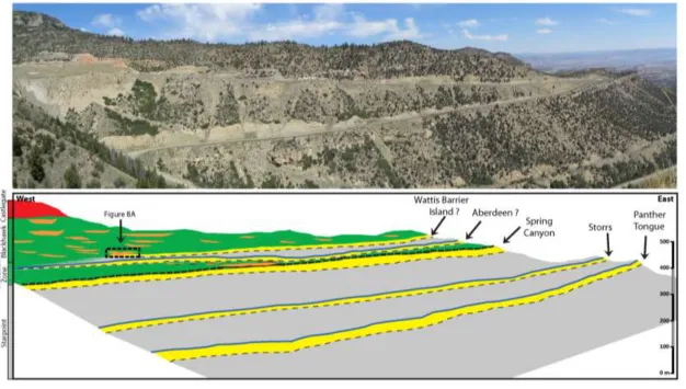
Not all prominent fluvial incision can be interpreted as a fall in base level and therefore a sequence boundary. At the Wattis Road outcrop, a fluvial channel was identified eroding down into the marine sandstone (Fig. 8A). Evidence associated with this fluvial channel points to a different
mechanism for incision, rather than a sea-level fall. Interesting clues such as the multiple erosional surfaces (Fig. 8B), marine influences when wave propagates upstream, and likely downstream continuation of this channel where it is filled with mudstones (Fig. 8C) were observed. This evidence suggests that the incision seen at the base of this channel is likely linked to a backwater effect at the river mouth (Parker et al., 2008; Petter, 2010).
23
24
downstream. This type of effect has not been documented in the sedimentary rock record;
nevertheless, it has been recorded in the modern environment. For example, the Mississippi River’s south-west pass has the backwater effect due to a micro-tidal control (Nittrouer et. al, 2011).
The appearance of multiple erosional scars at the channel base indicates a repeated
25
DISCUSSION
Transitional Complexity
Although down-dip pinch-outs of marine sandbodies (parasequences) are better known, their up-dip fate is less understood. A significant stratigraphic feature of the Wattis Road outcrop is the abrupt, up-dip pinch out of marine sandbodies within coastal plain mudstones (Fig. 6). A feature like this is difficult to pin down in subsurface studies involving wireline logs and cores. Therefore, large-scale outcrop windows like the one in the Wattis Road are suitable to investigate the nature of this up-dip pinchout. These up-dip pinch outs of shallow-marine sandbodies, which have inherited basinward depositional dip, are significant because of the potential for trapping hydrocarbons at the up-dip termination of the sandbodies. Encasing coastal plain mudstones can act as seals. Hydrocarbon could migrate up the marine sandbodies and accumulate where sandbodies abruptly pinches out into the mudstones. Knowledge of this complex facies transition in the Wattis Road in a marginal-marine setting can assist in predicting this type of stratigraphic traps in the subsurface.
Strike Variability of the Sequence Stratigraphy
26
However, there are other straigraphic boundaries that can be correlated inside this parasequence throughout the study area. There are subtle yet abrupt decrease in grain size within the overall upward coarsening trend of this parasequnce that likely indicate small fluctuations of sea level. These
boundaries are interpreted as intra-parasequence marine flooding surfaces.
A pair of sequence boundaries can be correlated from across the studied outcrop belt. The Wilberg, Des Bee Dove and Burma Road locations have distinct multi-storey channels that incise into the coastal plain mudstones. These channels are unlike of other simpler fluvial channel sandbodies gernally described in the lower Blackhawk Formation (Marley et. al, 1979; Adam and Bhattacharya, 2005). Similar sized incised valley fills have been described in the Book Cliffs further to the east (Adams and Bhattacharya, 2005).
27
One notable observation in the lateral transition from south to north is that the Blind Canyon coal zone likely merges laterally with a marine flooding surface at the Wattis Road outcrop. This
indicates, in general, that coal zones and marine flooding surfaces are likely equivalent surfaces resulting from base-level rise. Therefore in non-marine strata, coal can be used to identify flooding events.
Paleogeography
Summarizing the results of this study, a paleogeographic scenario of the north-eastern Wasatch Plateau during the Companian can be interpreted. Two paleogeographic models can be created, one during a highstand systems tract (HST) and another during a lowstand systems tract (LST) (Fig. 9).
During the HST the western shoreline of the Western Interior Seaway had a normal
prograding profile. The shoreline was keeping pace with sea-level rise, due to the high sediment supply being sourced from the Sevier Orogeny (Willis, 2000; Kaufmann and Caldwell, 1993). The coals, which developed oonn coastal plain, is interpreted to indicate heavily vegetated swamps just landward of the shoreline. Shoreline towards the north had bay environments. Inclined heterolithic strata also indicates that tidal channels were present in the northern section, where the tidal range of the seaway is
28
Figure 9: Paleogeography of the study area during the Campanian (~80 Ma ago). Left map is during highstand systems tract, when coastal plain is dominated by fluvial channels. The coast is featured with tidal channels, fluvial deltas, and likely barrier islands. Whereas the right map represents lowstand systems tract with the formation of incised valleys. Multiple incised valleys are developed along strike during the base level fall, separated by interfluves.
29
Back Water vs. Sea-Level Drop
30
CONCLUSION
The upward transition from marine to coastal plain strata has been commonly described as a rather smooth, gradual transition at the north-eastern Wasatch Plateau’s study locations. However, the Wattis Road outcrop (northern part of the study area) has a complex spatio-temporal transition from shallow-marine environment to coastal/fluvial environment. Eight distinct depositional environments were identified as part of this stratigraphic transition between shallow-marine Star Point Formation and coastal-plain Blackhawk Formation. This study demonstrates that the marine and non-marine strata are likely more complexly intertongued in the sedimentary record than what has been depicted in general. The stratigraphy of the Wattis Road outcrops documents the high-frequency sea-level fluctuations of the Western Interior Seaway during the late Cretaceous that generated sequence stratigraphic complexity. This study also documents abrupt, landward pinch-outs of shallow-marine sandbodies within coastal plain mudstones, a least-understood aspect of shoreline sedimentology. These pinch-outs can serve as excellent stratigraphic traps of hydrocarbons.
31
area. The sequence stratigraphic framework of the study area helps confirm the high frequency sea-level fluctuations of the WIS during the late Cretaceous that generated stratigraphic complexity.
32
References
Adams, M.M. and Bhattacharya, J.P., 2005: No change in fluvial style across a sequence boundary, Cretaceous Blackhawk and Castlegate Formations of central Utah, USA: Journal of Sedimentary Research, 75, p. 1038-1051.
Allen, J.L., 1983: Studies in fluviatile sedimentation: bars, bar complexes and sandstone sheets (low- sinuosity braided streams) in the Brownstones (L. Devonian), Welsh Borders: Sedimentary Geology, v. 33, p. 237 – 293.
Bernard, H.A., 1970: Recent sediments of southeast Texas: Texas Univ. Bur. Econ. Geology Guidebook Number 11.
Clark, F. R., 1928: Economic geology of the Castlegate, Wellington, and Sunnyside quadrangles, Carbon County, Utah; USGS Survey Bulletin, p.165.
Chow, V. T., 1959: Open-Channel Hydraulics; 680 pp., McGraw-Hill, New York.
Cobb, J.C., and Cecil,, C.B., 1993: Modern and ancient coal-forming environments; GSSA Speciall Paper 286, p. 198.
Coleman, J.M., 1966: Ecological changes in a massive freshweater clay sequence: Gulf Coast Assoc. Geol. Soc. Trans., v. 16, p. 159-174.
Dalrymple, R.W., Zaitlin, B.A., and Boyd, R., 1992: Estuarine facies models:conceptual basis and stratigraphic implications; Journal of Sedimentary Petrology; v.62, p. 1130 – 1146.
33
Dubiel, R.F., Kirschbaum, M.A., Roberts, L.N.R., Mercier, T.J., and Heinrich, A., 2000: Geology and coal resources of the Blackhawk formation in the southern Wasatch Plateau, central Utah; USGS professional paper 1625-B, United Stated Geological Survey.
Ericksen, M. C., and Slingerland, R., 1990: Numerical simulations of tidal and wind-driven circulation in the
Cretaceous Interior Seaway of North America; Geological Society of America Bulletin, v. 102, no. 11, p.
1499-1516.
Flores, R.M., Blanchard, L.F., Sanchez, J.D., Marley, W.E. and Muldoon, W.J., 1984: Paleogeographic controls of coal accumulation, Cretaceous Blackhawk Formation and Star Point Sandstone, Wasatch Plateau, Utah.
Geol. Soc. Am. Bull., 95, 540-550.
Gani, M.R., and Bhattacharya, J.P., 2007: Basic building blocks and process variability of a Cretaceous delta: internal facies architecture reveals a more dynamic interaction of river, wave and tidal processes than is indicated by external shape. Journal of Sedimentary Research, v. 77, p. 284-302.
Gani, M.R., Bhattacharya, J.P., MacEachern, J.A., 2008. Using Ichnology to Determine Relative Influence of Waves, Storms, Tides, and Rivers in Deltaic Deposits in the Cretaceous Western Interior Seaway, Wyoming-Utah, U.S.A. Short Course Notes 51, Society for Sedimentary Geology.
Hamblin, A.P. and Walker, R.G., 1979: Storm-dominated shallow marine deposits; the Fernie-Kootenay (Jurassic) transition, southern Rocky Mountains; Can. J. Earth Sci., v. 16, p. 1673-1690.
34
Harms, J.C., Southard, J.B., Spearing, D.R. and Walker, R.G., 1975: Depositional environments as interpreted from primary sedimentary structures and stratification sequences; Soc. Econ. Palont. Mineral Short Course 2, 161 p.
Henry, E.H. and Finn, T.M., 2009: Petroleum assessment of the Ferron/Wasatch Plateau total petroleum system, upper Cretaceous strata, Wasatch Plateau and Castle Valley, Utah; American Association of Petroleum Geologist; Journal, p. 45
Holman, L. S., 2011: The effect of parasequence and geometry and facies architecture on reservoir partitioning of the Star Point Sandstone, Wasatch Plateau, Utah; American Geological Institute, Brigham Young University, master thesis.
Howell J.A. and Flint S.S., 2003: Siliciclastics case study: the Book Cliffs: The sedimentary record of sea-level change, pp. 135-208. Cambridge University Press.
Jackson, R.G, II, 1975: Hierarchical attributes and the unifying model of bed forms composed of cohesionless material and produced by shearing flow: Geological Society of America, Bulletin, v. 86, p. 1523 – 1533.
Kauffman, E. G. and Caldwell, W.G., 1993: The Western Interior Basin in space and time - Evolution of the Western Interior Basin; Geological Association Canada, Special Paper, 39.
35
Marley, W.E., Flores, R.M. and Cavaroc, V.V., 1979: Coal accumulation in Upper Cretaceous marginal deltaic environments of the Blackhawk Formation and Star Point Sandstone, Emery, Utah: Utah Geology, 6, p. 25-40.
Miall, A.D., 1983: Basin analysis of fluvial sediments in J.D. Collinson and J. Lewin, eds., Modern and ancient fluvial systems; Internat. Assoc. Sedimentologists Spec. Geol., v. 21, p. 85-127.
Nittrouer, J.A., Shaw, J., Lamb, M. P., Mohrig, D., 2011: Spatial and temporal trends for water-flow velocity and bed-material sediment transport in the lower Mississippi River; Geological Society of America Bulletin, pre-issue publication.
Parker, G., Muto, T., Akamatsu, Y., Dietrich, W.E. and Lauer, J.W., 2008: Unravelling the conundrum of river response to rising sea-level from laboratory to field. Part II. The Fly-Strickland River system, Papua New Guinea: Sedimentology, 55, 1657-1686.
Parker, L.R., 1976: The paleoecology of the fluvial coal-forming swamps and associated floodplain environments in the Blackhawk Formation (Upper Cretaceous) of central Utah. Brigham Young University Geol.
Studies, 22, 99-116.
36
Petter, A.L., 2010: Stratigraphic implications of the temporal variabilioty of sediment transport in rivers, deltas, and shelf margins. Unpubl. PhD thesis, University of Texas at Austin, 205 pp.
Sheldon, N.D., and Tabor, N.J., 2009, Paleoenvironmental and paleoclimatic reconstruction using paleosols: Earth-Science Reviews, v. 95, p. 1-52.
Spieker, E.M., 1931: The Wasatch Plateau coal field, Utah. U.S. Geol. Surv. Bull., 819, 210 p.
Taylor, A.M., and Goldring, R., 1993: Description and analysis of bioturbation and ichnofabric: Geological Society of London, Journal, v. 150, p. 141-148.
Taylor, D.R. and Lovell, R.W., 1995: High-frequency sequence stratigraphy and paleogeography of the Kenilworth Member, Blackhawk Formation, Book Cliffs, Utah, USA: American Association of Petroleum Geologist Memoir, 64, 257-275.
Thomas, R.D., D.G. Smith, J.M. Wood, J. Visser, E.A. Calverly-Range and E.H. Koster. 1987: Inclined
heteolithic stratification – terminology, description, interpretation and significance: Sedimentary
Geology 53: 123-179.
Van Wagoner, J.C., 1995: Sequence stratigraphy and marine to non-marine facies architecture of foreland basin strata, Book Cliffs, Utah, USA: American Association of Petroleum Geologist Memoir, 64, 137-223.
37
Wright, L.D., 1979: Morphodynamics of reflective and dissipative beach and inshore systems, southeastern Australia: Marine Geology, v. 32, p. 105-140.
Yoshida, S., Miall, A., Willis, A., 1998: Sequence stratigraphy and marine to nonmarine facies architecture of foreland basin strata, Book Cliffs, Utah, U.S.A.; American Association of Petroleum Geologist Bulletin, v. 82, no. 8, p. 1596-1606.
Young, R. G., 1955: Sedimentary facies and intertonguing in the upper Cretaceous of the Book Cliffs, Utah-Colorado; Geological Society of America, Bulletin, 66.
38
Appendix
39
Appendix Figure 2: (upper) Photomosaic and (lower) corresponding facies and sequence stratigraphic diagram of the outcrop at Burma Road section, showing a slightly complex upward transition from marine to non-marine strata. The lower sequence boundary erodes into the upper marine sandbody
40
Appendix Figure 3: (left) Photo and (right) corresponding facies and sequence stratigraphic diagram of the lower incised valley fill at the Burma Road outcrop. The incised valley erodes into the Spring Canyon Member. Note the marine sandstone’s bedding surfaces are truncated by the incised valley. The incised valleys that were observed in this study outcrops have an average relief of 7-9 meters whereas the average thickness of the non-incised fluvial
41
42
Appendix Figure 5: (upper) Photomosaic and (lower) corresponding facies and sequence stratigraphic diagram of the outcrop at Des Bee Dove Mine section, showing a simple and gradual upward transition from marine to non-marine strata. However, this is the most northern outcrop where the fluvial
43
Appendix Figure 6: (upper) Photomosaic and (lower) corresponding facies and sequence stratigraphic diagram of the outcrop at Wilberg Mine section, showing the gradual upward transition from marine to non-marine strata. Note the presence of two complex channel belts forming. These are interpreted
44
Appendix Figure 7: A coal mining core was examined to reveal the details of the transitional zone from marine to non-marine strata. This core was teken between Trail Mountain Mine and the Wilberg Mine locations. For
45
Appendix Figure 8: Inclined heterolithic stratification (IHS) is used to describe the sand and mud beds that are regularly repeating and being deposited as couplets in tidal point bar environments. At the Wattis Road outcrop (A), laterally extensive IHS was visible above the Axel Anderson-Cottonwood-Spring Canyon Coal Seam. In figure B, the bedding diagram shows the complex stratal geometry of the IHS. Another IHS deposit was identified at the Wilberg Mine outcrop (C). In figure D, the grain size of this IHS variation is documented, both vertically and laterally. Note that at the down-dip side of each inclined
46
Vita
Andrew Ranson was born and raised in New Orleans. He attended St. Rosalie Elementary School in Marrero, followed by Brother Martin High School in the Lakefront area. After high school Andrew attended Louisiana State University pursuing a degree in Petroleum Engineering. After have taking his first Geology class his sophomore year, Andrew decided to switch majors. He transferred to the University of New Orleans and enrolled in the Earth and Environmental Sciences department. As an undergrad, Andrew was asked to be a field assistant for Dr. Royhan Gani in the Wasatch Plateau, Utah. While working in Utah, Andrew was amazed at the quality of outcrop exposures, and started to work on a senior thesis. Andrew presented his thesis at the 2010 American Association of Petroleum Geologist annual convention in New Orleans. After the completion of Andrew’s undergraduate degree he
continued his studies at UNO under the guidance of Dr. Gani to expand on his senior thesis and create it into a master’s thesis. While getting his master’s, Andrew married Ashley Breaux from Berwick,