J.micropalaeontol., 4(1): 1-10, March 1985
Stratigraphic and Structural Setting
A. El-ARNAUTI' & M. SHELMAN12
'Department of Geology, University of Garyounis, Benghazi, Libya, S.P.L.A. J. 2Arabian Gulf Oil Company, Benghazi, Libya, S.P.L.A.J.
INTRODUCTION
The material which forms the basis of this project was obtained from a number of wells in the study area in Cyrenaica, the northeastern part of Libya. The study area, which is located between latitudes 25" and 33"N and between longitudes 20" and 25"E, covers some 365,750 square kilometres (see Fig. 1). The area extends from the Egyptian border in the east to the eastern flank of the Sirte Basin in the west and is part of the stable Saharan Shield.
Since Precambrian time several phases of epeirogenic movements have produced troughs, horst blocks or plat- forms which have in turn influenced the subsequent sedimentological history of the area. In the southern and southeastern part of the study area, the basement is unconformably overlain by a thick, partially marine Palaeozoic sequence which is in turn unconformably overlain by sediments of Jurassic or younger age. The basement in the central and southwestern parts of the area is unconformably overlain by non-marine clastics of Late Jurassic and Early Cretaceous age or by marine sediments of Late Cretaceous and Tertiary age. In the eastern and northeastern section the basement is over- lain by a wedge of eastward thickening marine Palaeozoic rocks which are in turn unconformably overlain by marine sediments of Late Cretaceous and Tertiary age. In the most northerly part of the northeastern region of the study area, a thick paralic sequence of Triassic, Jurassic and Early Cretaceous deposits is unconformably overlain by Late Cretaceous and Tertiary sediments.
PALAE OZ OIC
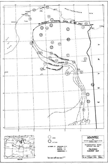
Rocks of Cambro-Ordovician to Permian age are known extensively throughout the central and southern parts of the study area. The only exception being the Late Carboniferous-Permian which is present only locally in the northern part. Because of the complexity of depositional environments resulting in the development of various facies within the area, it is imperative that each system is discussed separately.
CAMBRO- ORDOVICIAN
The sub-crop distribution of Cambro-Ordovician rocks in the study area is shown in Fig. 2. The true thick- ness cannot be determined because only a few wells have been drilled to the basement, however, interpretation
from the regional cross-section (Fig. 6) indicates vari- ations from 200 to 2000ft. These variations have traditionally been attributed to post-Cambrian tectonic activity and subsequent erosion which has resulted in the removal of parts of the sequence.
Lithologically this sequence is dominated by reddish brown, very fine to medium grained, subangular and well-sorted quartz arenites interbedded with siltstones and shales. Occasionally at the base of the sequence, the sandstone is subrounded and frosted and contains abundant feldspar and mica, suggesting derivation from a granitic basement. This sandstone is the possible correlative of the massive cross-bedded sandstone known from surface exposures in the northeast part of the Kufra Basin. The presence of Tigillites in this sand- stone in the Kufra Basin suggests deposition in a near- shore, tidal environment which contrasts strongly with the sandstone of continental origin in the study area.
No palynomorphs have been recovered from any of these sediments but their lithological similarities and probable stratigraphic position relative to the Tigillifes
bearing sandstone in the Kufra Basin suggests a Cambro-Ordovician age.
ORDOVICIAN
Ordovician rocks are present in the southern part of the study area and have been encountered in wells El-81, J1A-81A and I1C-81A with a variation in thickness of between 400 and 2000ft. They consist predominantly of greyish-white, fine to coarse grained subrounded to subangular micaceous sandstone inter- bedded with dark grey shale and siltstone.
The presence of acritarchs and chitinozoans of late Early Ordovician to Late Ordovician (Caradocian to Ashgillian) age indicates the beginning of the first marine transgression in the area. The sediments are in part correlatable with the Melez-Chograne and Memouniat Formations of the Kufra Basin and else- where in western Libya.
SILURIAN
El-Arnauti & Shelmani
c..
--
I ,_."PALYMSTRATIGRIPHI PROJECT NORTWEaST LInvA. 1984 MAJOR STRUCTURAL
ELEMENTS
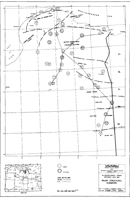
Fig. 1. Major structural elements in northeast Libya.
Stratigraphic and structural setting
trated a complete sequence. In the study area, the Silurian sediments consist of a lower graptolitic shale unit overlain by siltstones and sandstones. In wells A1-81 and El-81, the graptolitic shale has been dated as Early Silurian and this is now supported by the occurrence of Llandovery acritarchs and chitinozoans. Preliminary palynological analysis of the Silurian section in well A1-46 has demonstrated the presence of Llandovery and Early Wenlock acritarchs and chitinozoans, while Late Silurian (Ludlow) acritarchs have been encountered in well A1-81A only.
The Silurian succession appears to have been deposited in shallow marine environment but the transition from Lower Silurian graptolitic shale to Upper Silurian sand- stone and siltstone suggests a possible regressive phase of sedimentation. The Silurian deposits in the study area is partly correlatable with the Tanazzuft Formation in the Hamada Basin in western Libya.
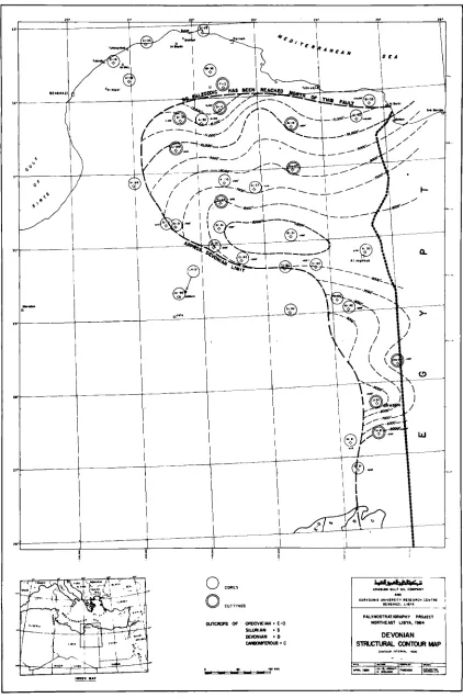
DEVONIAN
Devonian sediments are present extensively throughout the study area except in the region of well El-81 (Fig. 6) in the southern part. The thickness of the Devonian succession varies from 800ft. in well J1-81A to 3000ft. in well B1-31.
Earliest Devonian deposits are known in Well A1 A-84A where a Gedinnian age has previously been suggested (AGOCO Internal Report). They consist of white, fine to medium grained partly ferruginous sand- stone rich in mica and grey micaceous shale. The sedimentary facies, together with the presence of acritarchs and miospores suggest a near shore marine environment of deposition.
Rocks of Middle Devonian age have been encountered in wells J1A-81A and I1C-81 in the southeastern part of the study area as well as in wells A1-120 and B1-31 in the central region and well A1-NC92 in the northern part. The deposits are composed of silty micaceous shale interbedded with white, grey and brown calcilutitic lime- stone which are considered to have been deposited in a shallow marine environment.
The Upper Devonian is represented in wells J1-81A and I1C-81 in the southern part of the study area by white and grey fine grained, well-sorted sandstone inter- calated with dark brown, partly anhydritic shale. To the north this interval is mainly represented by dark grey, partly micaceous shale interbedded with grey-green, fine grained, micaceous and glauconitic sandstone. A continental fluvio-deltaic sedimentary environment is suggested for these deposits. Upper Devonian deposits are so far unknown from the central part of the study area.
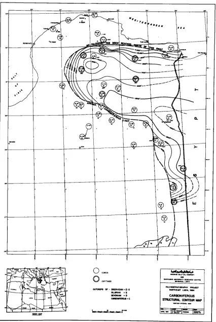
CARBONIFEROUS
The Carboniferous rocks are distributed extensively in the area (Fig. 4) but are absent in wells El-81 and
B1-31 (Fig. 6). The total known thickness varies from 1500 to 5600ft. The majority of the sequence in the southern part of the study area is represented by rocks of Early Carboniferous age consisting of white, coarse to very coarse, rounded and well sorted quartzitic sand- stone. These sandstones are commonly interbedded with dark grey siltstone and pale green or brown haematitic shale with occasional streaks of brownish to black coal. These Early Carboniferous sediments reach a maximum thickness of 1500ft. in well J1-81A where the palynomorph assemblages suggest a Visean or younger age.
In the central part a 1000ft. thick section of probably Late Carboniferous age is present in well A1-120. Lithologically this sequence consists of fine to coarse grained, sub-angular to sub-rounded, well sorted and well-cemented sandstone interbedded with red- brown silty shale with streaks of black shale towards the base and white chalky limestone towards the top.
An almost complete Carboniferous (Tournaisian to Westphalian) section, nearly 5600ft. thick is present in well A1-NC92 in the northern part of the area. The strata here consist of silty shale and siltstone with minor sand- stone units in the lower part and several types of lime- stone interbedded with shale in the upper part. These limestones are predominantly white in colour and include both oolitic and bioclastic types.
Generally, the Carboniferous sediments show facies changes from the south to the north. They are of con- tinental nature in the southern area and of mixed continental and marine character in the central part. A rather shallow marine aspect is significant in the northern area, where sedimentation is partially of delta front type prograding into shallow marine, locally inter- rupted either by lagoonal conditions or shoal banks.
The complete absence of Carboniferous sediments in wells El-81 and B1-31 and partial removal in wells J1-81A and A1-120 is attributed to a local erosionals effect caused by the Hercynian orogeny.
The Carboniferous transgression advanced from the north or northeast as indicated by the observed thickness variations and reached as far as the Kufra Basin.
PERMIAN
El-Amauti & Shelmani
Fig. 2. Palaeozoic subcrop map of northeast Libya.
Stratigraphic and structural setting
Palynological evidence confirms the presence of Early Permian sediments in wells A1-117, C1-33 and E1-2 and Early-early Middle Permian sediments in well AlA-84. There is no evidence for Late Permian sedi- ments in the study area.
MESOZOIC
Mesozoic sediments are widely distributed throughout the study area and range in age from Triassic to Late Cretaceous. The Late Cretaceous deposits are entirely represented by marine facies whereas the Triassic to early Cretaceous vary regionally from the north to south. In the northern area predominantly marine facies of considerable thickness is developed, the central area is transitional in character from shallow marine to con- tinental with clastic sediments interbedded with lime- stone and marine shale, whilst in the southern region exclusively continental sediments are developed.
TRIASSIC
Sediments of Triassic age were previously unknown in the study area but have now been identified in wells Jl-SlA, L4-51. A1-19 and A1-28 (see Figs. 6 and 7). In the southern (well J1-81A) and central (L4-51 and A1-96) parts of the study area, the Triassic sediments consist predominantly of sandstone and shale considered to have been deposited in a non-marine lagoonal environment. The presence of glauconite in the sedi- ments of the uppermost part of the Triassic section in wells L4-51 and A1-96 may however indicate limited local marine influences. To the north in well A1-28, the Triassic is represented by approximately 500ft. of lime- stone interbedded with glauconitic shale which are considered to be of shallow marine origin.
N o early Triassic sediments have been encountered during the course of the present study. Middle Triassic sediments were reported in well L4-51 and Late Triassic sediments in wells A1-28, A1-19 and J1-81A. With the exception of the palynomorph assemblages recovered from well A1-28, all of the other wells contain terrestrially derived palynofloras indicating deposition in a non- marine environment.
JURASSIC
Jurassic deposits are widely represented throughout the study area and show significant facies differences from south to north. The maximum development of the system is in the north in well A1-36 where it attains 3955 ft., it is similarly thick in the southern area but in the central region is more variable, being absent al- together in some wells (Al-115).
In the south (well J1-81A) the Jurassic deposits con- sist of 800ft. of white to red, fine to medium grained sandstone intercalated with brown to red shale and haematitic claystone. The grain size, colour and the occurrence of loose quartz grains suggest these to be the
erosional product of Palaeozoic sediments. In the central region the Jurassic deposits are either very thin (well A1-19) or completely missing (well A1-115). Where present they are represented by sandstone inter- bedded with oolitic limestone and shale. In well A2-2, limestone dominate the succession but carbonate with rare dolomite occur in the upper part and are inter- bedded with shale and sandstone. In contrast well C1-2 shows the development of an increased sand facies. The sedimentary features suggest a paralic depositionary regime in the central area. In the northern part of the study area the Jurassic is often up to 1OOOft. thick (well C1-18) and is represented by light brown to light grey oolitic limestone interbedded with minor greyish brown, silty pyritic shale and is thought to be deposited in a deeper marine environment.
Palynological studies indicate Early Jurassic sedi- ments to be present in well J1-81A but all other wells contain Middle to Late Jurassic.
EARLY CRETACEOUS
Early Cretaceous sediments in northeast Libya are generally similar in lithology and facies to those of the Jurassic. In the southern part of the study area they con- sist of white yellow and red, angular to subangular sandstone which are occasionally anhydritic and pyritic. Intercalations of grey to red silty shale and streaks of black amorphous coal are frequent in the upper part of the section. Almost 3000ft. of Early Cretaceous sedi- ments were penetrated in well J1-81A which is considered as a reference section for comparison.
In the central area the Early Cretaceous is represented by sandstones interbedded with thin layers of shale and anhydritic siltstone which are interpreted as deposits of mixed shallow marine and continental facies. In the south and southeastern part of the central area Early Cretaceous deposits are either very thin or absent. By contrast the Early Cretaceous sediments in the northern area are entirely marine (well C1-18) consisting of light grey to greyish green limestone with occasional chert nodules and minor siltstone intercalations. The lime- stone is oolitic in part and dolomitic towards the base. Biostratigraphic results suggest a Neocomian to Albian age for the central and northern sections and a general Early Cretaceous age for the southern sections.
LATE CRETACEOUS
El-Arnauti & Shelmani
1-4-
!-@-
0
CORESI .I
Stratigraphic and structural setting
' -I
El-Arnauti & Shelrnani
' I
0
C O I L 5Fig. 5 . Upper Cretaceous structural contour map.
Stratigraphic and structural setting
in well A1-115 are approximately 1800ft. thick and are represented by chalky limestones and dolomites of deep marine type (see Fig. 5).
More or less continuous sedimentation occurred in the northern part of the area from the central Jabal-Al- Akhdar to the coastal region. In the central Jabal-Al- Akhdar Uplift, the exposed Late Cretaceous varies from pelagic greenish, sandy marl with pyrite (Quasr Ahrar Formation) to neritic and dolomitic limestone with occasional bands of marly limestone (A1 Baniyah Formation). Both formations are Cenomanian to Coniacian in age and are in turr. unconformably over- lain by the Al Majahir Formation of Maastrichtian age composed of marly dolomitic limestone of neritic origin. In the northern coastal region, the exposed Late Cretaceous shales of the Al Hilal Formation are mainly of Cenomanian to Coniacian age. In Contrast to the central Jabal Al-Akhdar area, these sediments are conformably overlain by white, fine grained chalky and cherty linestones with contorted beds of the Al Athrun Formation which is of Maastrichtian age. Subsurface sections of Late Cretaceous in the northern coastal region include 1400ft. of white to light brown, soft, fossiliferous limestone with chert nodules interbedded with grey-green calcareous silty shale in well C1-18. These sediments are considered to represent a shallow marine environment of deposition.
TECTONICS
The surface morphology of the study area is marked by Jabal-Al-Akhdar in the north and the northern heights of the Kufra Basin (Jabal Dalma) in the south. Between these two orographic features, a vast, nearly plain surface occupies the area. It is covered either by recent dunes or Sarir gravel.
The Phanerozoic history of this part of the African Craton is affected by epeirogenic movements in the form of block tectonics. Unconformities in the stratigraphic succession as indicated by palynological age deter- minations permit the recognition of the diastrophic events to be ascribed to the “Caledonian”, “Hercynian” and “Post-Hercynian” epochs.
The stratigraphic correlations as shown in the cross- sections (Figs. 6, 7) exhibit a variety of subsurface structural elements. From south to north the following horst structures and faulted uplifts associated with basinal features are recognised (Fig. 1).
1. Dalma High: This is a structural high between the northern edge of the Kufra Basin and southern part of the study area. In the Well El-81, Ordovician rocks were encountered at a depth of 3050ft. thus suggesting the Precambrian basement is at relatively shallow depths in this area. The Palaeozoic and Mesozoic strata dip east towards north and northwest.
2. Quattara Graben: Although it is only a short distance
to the north of the former structure, the Precambrian basement is encountered here in the Well J1-81A, at a depth of 13300ft. and demonstrates the existence of a northeast-southwest (east-northeast and west- southwest) trending graben. The down faulting of this graben started in the Early Mesozoic and was re- activated in the Early Cretaceous. Emsian sediments were found in this area to unconformably overlie those of Ordovician age. The absence of Silurian strata demonstrates the impact of the Caledonian orogeny. The area which is now a graben received a moderate supply of sediments until Carboniferous time and was subsequently uplifted during the Hercynian orogeny. No Late Carboniferous and Permian palynomorphs were recovered in this area.
3. The Siwa High: This is located near the Well Al A-84. The absence of Triassic, Jurassic and parts of Early Cretaceous here is very likely due to faulting and gradual upheaval accompanied by erosion during Late Permian to Early Cretaceous.
4. The Jagbub Trough: The Siwa High is flanked to the north by the Jagbub Trough. This trough can be con- sidered as part of the Sirte Basin. Hercynian movements initially uplifted the area, resulting in the erosion of Late Carboniferous, Permian and even some Triassic sedi- ments, followed by subsidence which resulted in the accumulation of thick continental deposits of Jurassic/ Early Cretaceous age and later of younger marine sediments.
5. The Jagbub High: To the north of the Jagbub Trough, a basement High seems to have persisted since Hercynian times. The Well B1-31 encountered a Palaeozoic sequence of Silurian to Devonian (Frasnian) age. It is disconformably overlain by continental Mesozoic deposits. The upward movement led to a general truncation and tilting of the Palaeozoic sequence towards north and northeast to form the Western Desert Basin. The Jagbub High remained as a block even at the beginning of the Mesozoic.
El-Arnauti & Shelmani
times as documented by periods of erosion and deposition of continental clastic sediments. The area developed into a continental shelf during a major Late Cretaceous transgression. Further carbonate accumulation followed in the Tertiary resulting in the development of the Cyrenaica Platform.
7. Ajdabia - Sceleidima Trough: This trough is situated beyond the northwestern edge of the Cyrenaica Plat- form. The oldest sediments known in this trough are of Jurassic age. The top of the Upper Cretaceous is reached in several wells at: 7710ft. in A1-35.8200ft. in G1-41, 9200ft. in C1-41 and 12000ft. in A1-89 (offshore), from east to west respectively. The depth to the top of the Upper Cretaceous indicates a trough plunging southwest.
The final shape of this trough can be considered to have been attained between Early Cretaceous and Tertiary times, although a Palaeozoic element is partially responsible for its development. The trough is a down- faulted block, limited to the north by a northeast trend- ing fault of Late Cretaceous age. The southern limit of the trough is a Palaeozoic hinge line under the north- western fringe of the Cyrenaica Platform. These faults intersect at an acute angle towards the northeast near the Well A1-35.
8. Marmarica -Tobruk Trough: Here is an east north- east plunging negative feature, situated to the northeast of the Cyrenaica Platform. The trough is bounded to the southeast by two faults of Late Mesozoic (Jurassic/Early Cretaceous and Late Cretaceous). Towards the north- west and north, it is limited by another Upper Cretaceous fault line along which the Jabal-Al-Akhdar was uplifted. Thick Mesozoic sediments of marine Jurassic are present in the trough (Well A1-36). The rate of subsidence in Early Cretaceous resulted in the development of paralic sediments. In the Late Cretaceous and Tertiary a further subsidence took place relative to the rising Jabal-Al- Akhdar.
9. Jabal-Al-Akhdar Uplift: The Western Desert Basin and the Cyrenaica Platform are terminated sharply to the north by the uplifted and exposed block of Jabal- Al-Akhdar. It is a gentle domed complex with an axial trend in a northeast - southwest direction and consists mostly of marine carbonates. Although the wells drilled in the Jabal-Al-Akhdar area e.g. B1-36, reached a depth of 1OOOOft. neither the Precambrian cystalline basement nor sediments older than Late Jurassic were encountered. The subsurface thickness of Late Jurassic and Early Cretaceous in Jabal-Al-Akhdar reaches 12000ft. Sediments of the same age in the subsurface of the northern Cyrenaica Platform on the contrary, are reduced in thickness to 3000ft. The abrupt thickening and the associated more matrine character of the sedi- ments towards the north, especially those of Early Cretaceous age, suggests that the Jabal-Al-Akhdar area was a fast sinking trough separated from the consolidated
Western Desert Basin by a nearly east-west trending fault of the Late Jurassic to Early Cretaceous age (Fig. 6). The confirmation of subsurface Triassic sedi- ments of different sedimentary character in the Jabal- Al-Akhdar area (Well A1-28) and to the south (Well L4-51), assigns an older age to the above mentioned fault. The subsidence of the “Jabal-Al-Akhdar Trough” was reversed in the Late Cretaceous. Uplifts occurred along new faults parallel or nearly parallel with the Late Jurassic
- Early Cretaceous fault zone. Supporting
evidence of this is the reduced thickness of the Late Cretaceous and the shallow marine nature of the carbonates in the central part of the Jabal-Al-Akhdar (Well A1-18), when compared with the northern zone (Well C1-18) and the northern Cyrenaica Platform (Well A1-36). Since the Late Cretaceous, the Jabal-Al- Akhdar has been subjected to several tectonic move- ments as reflected in the unconformities of post- Palaeocene age, until it gained its present configuration.REFERENCES
Bonnefous, J. 1972. Geology of the Quartzitic “Gargaf Formation” in the Sirte Basin, Libya. Bull. Centr. Rech. Pau. SNPA, 6 (2), 225-261.
Chalco, A. 1980. Regional Geology & Hydrocarbon possi- bilities of North Central Cyrenaica. AGOCO Geol. R e p . 190.
Chalco, A. 1982. Geology & Hydrocarbon Potential of Palaeozoic - Mesozoic in Cyrenaica. AGOCO Geol. R e p . 218.
Klitzsch, E. 1971. The structural development of parts of North Africa since Cambrian time In: Gray, C. (Ed.),Syrnp. Geol. Libya, Fac. Sci. Tripoli, 253-262.
Mikbel, R.S. 1979. Structural and Configuration map of the Basement East and Central Libya. N . Jb. Geol. Palaeont., Roehlich, P. 1979. Geological Development of Jabal-Al-
Akhdar, Libya. Geol. Rundsch., 67 (2), 401-412.
Turner, B. R. 1980. Palaeozoic sedimentology of the south- eastern part of the Kufra Basin, Libya: A model for oil exploration. In: Salem, J. & Busrewil, M. (Eds.), Thegeology of Libya, Tripoli, 2, 351-374.
Van Houten, F. B. 1960. Latest Jurassic-Early Cretaceous regressive facies. N E African Craton. Arner. Assoc. Pet.
Geol., Bull., 64 (6), 857-867. Abh., 158 (2), 209-220.