Integrated solid waste management using remote sensing and GIS
approaches in city areas.
M.Vivek
1, T.Vengatesan
2, S.Joseph raj
3,S. Ashok kumar
4, S.Sathya narayanan
5,
I.Justin Antony raj
61, 6 Assistant Professor, Department of civil & Mechanical Engineering, Vandayar engineering college ,
Thanjavur-613501-TN-india.
2,3,4,5 UG Scholar, Department of Civil Engineering, Vandayar engineering college, Thanjavur-613501-TN, India.
---***---
Abstract: Solid waste management is a global environmental problem in today’s world. Urban solid waste management is considered as one of the most serious environmental problem in developing countries. One of these impacts are due to location of dumping site in unsuitable area’s which results in transmission of diseases, atmospheric pollution etc. This project deals with determination of suitable site for disposal of solid waste in thanjavur using remote sensing and GIS software – Arc GIS 9.3. For the location of disposal site seven different criteria (Land use, Soil, Slope, Drainage, Lineament, Geology, and Geomorphology) are examined in relation to site selection. Each criterion is identified and weighted. Then each criterion is mapped using the GIS technique. After GIS analysis, three regions are obtained – Unsuitable, Moderately suitable, Most Suitable. Finally, the most suitable region is selected for solid waste disposal and this site is checked through field visit.
Keywords: Solid waste management, remote sensing ,GIS software, solid waste disposal.
1. INTRODUCTION
The sites determined as suitable for landfill are confirmed with field checks. A detailed feasibility study should be carried out on the selected area, Minimize all pollution risks with a view of environment protection is studied. The detailed investigation is carried out in integration of various parameters through IRS- P6 LISS. Thus with the use of these technologies management of city will no longer be a problem for city administrators is also studied. (E. Tinmaz and I. Demir, 2016) “The issue of waste is not only because of increase quantities but also largely because of inadequate management system”. One of the major management issues in solid waste management is improving methods for interpretation of data “(Dr. Vhora, 2016) Billions spent in improving scientific methods for interpretation of data, but the steps involved in the said area are much demanding”. Almost all of factors related to solid waste management have a spatial component as well as non-spatial data. Manual methods used for analysis of many factors are lengthy and tedious work and in some problems it will be difficult to solve them without the aid of computer software, e.g. optimization software, and also there is possibility of merging spatial and non-spatial data. In most cases solid waste data and records are not
due un-aesthetic conditions and over all leaves a bad impression and poses a threat to the environment.
2. LITERATURE SURVEY:
Saunas, et.al, (2018), had studied about the site selection for solid waste disposal in turkey using GIS, AHP (Analytical Hierarchy Process), and remote sensing method. For this study ten different criteria’s are examined & they are identified and weighed using AHP. They are mapped using GIS technique & suitability map is prepared by overlaying. Finally, suitable regions in the basin are determined for solid waste disposal, protecting our environment and checked in the field.Adnoun, et.al, (2018), discussed the selection of site for disposing the solid waste in Nigeria. Digitizing is done using GIS software’s such as ArcView. The proposed site should be considered as appropriate waste disposal / landfill sites and as such approved for location. Hassan, et.al, (2018), had discussed the landfill demand fordisposal of MSW of dhaka; the capital of Bangladesh is assessed by projecting population and waste generation. Tamilenthi, et.al, (2017), studied to find out the potential waste disposal sites in Sakkottai located in Sivagangai district using remote sensing and GIS techniques. Research gap: Author’s are researched over Integrated solid waste management using remote sensing and GIS approaches in city areas.
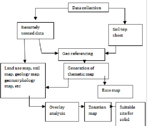
3. METHODOLOGY
3.1 GENERAL:
The broad objective of the project is to find a suitable site for solid waste disposal .This can be performed by using Arc GIS 9.3 software. Remote sensing and geographical information system (GIS) addresses the problems related to solid waste management. Basically, two types of data are to be generated along with other collateral data from different sources for desired accuracy parameters. Initially map is prepared from the sources. Two sources are taken, one is the remotely sensed data and other is the Survey of India (SOI) Toposheet. The scale taken for the Toposheet is 1:50,000. For the RS data it obtains the data from the satellite. First step is the geo- referencing and this data obtained from the sources are digitized. Second step is the generation of thematic maps. This map includes the following maps they are base map, land use/ land cover map, soil map, geology map, geomorphology map, lineament map, drainage map, drainage density map and slope map. The next step is to assign the rank and weightage for each map and multiplying the values and then adding the values for all maps, the process of overlaying is done then the Zonation map is prepared. From the zonation map three regions are obtained – Unsuitable site, moderately suitable, most suitable. Finally, the most suitable site is chosen for disposal of solid waste and they are checked through field visit. After studied well the literature, we have planned to conduct and determine
the suitable and apt space for the location for dumping solid waste.
3.2 STUDY AREA:
Thanjavur Corporation (Selected Area),Latitude: Between 10:44’00’’ to 10:52’00’’,Longitude: Between 78:38’00’’ to 78:46’00’’,Area: 38.33 Sq. Km, Population: 8, 25,813(as per census of 2011),No. of wards: 50,Climatic conditions: Summer: 41.10:C (max), 36.40:C (min),Winter: 21.31:C (max), 18.60:C (min).
3.3. CLIMATE AND RAINFALL:
Climate of thanjavur city is usually hot and dry. Months of april, may, and June are almost unbearable due to excess heat. Last 30 years average data shows that maximum temperature during may month is about 37.5:C and minimum temperature is 19.9:C.Thanjavur City receives maximum rainfall during NE monsoon. it’s not directly affected by cyclonic storms and heavy rainfall because of its interior location.
3.4. POPULATION:
The population of thanjavur city was 6,68,648 in 1991 which is increased to 9, 16,674 in 2011, hence the average increase in the population is 27.1% between 1991 and 2011.The Male population is 4,52,689 and the Female population is 4,63,961 in 2011.
3.5. PHYSIOGRAPHY:
This area is pale embayment during cretaceous forming the extremity of ariyalur, pondicherry depression which part of cauvery river flowing through area in NW-SE direction.
3.6. LANDUSE:
The major crops grown in this district are rice, pulses, millets and other cereals, groundnut, sugarcane, cotton, gingerly etc. Sericulture was introduced in thanjavur district in the late 70`s and the progress is slowly picking up. At present, it has got mulberry cultivation involving about three hundred and eight Seri culturists in silkworm rearing.
3.7. SOIL:
Further south, the surface is covered by poor-quality soil. The other soil types like clay, red ferruginous etc., are occupying the remaining extent of land cover the district.
3.8.GEOLOGY:
trending lineament demarcating the above two lithological area. The cretaceous formation in the north-eastern part of the district overlapping the Ariyalur of upper cretaceous formation.
3.9. GEOMORPHOLOGY:
The major part of the district is an undulating Pedi plain. Bad land topography with active gully erosion is seen between thanjavur and thiruchirapalli.
3.10. TRANSPORTATION:
Thanjavur district is well connected with major cities in tamilnadu by rail and road network. By virtue of central location, thanjavur city has become the meeting place of transportation lines (both road and rail) from north to south and east to west while travelling across the state. The influence of thanjavur extends up to cuddalore, villupuram, vellore, salem, erode, dindugul, and Pudukottai districts. The important roads traversing in the region are national highway No.5 (Chennai- Dindugul NH), madurai road (S.H), pudukottai road (S.H), tiruchirapalli road (S.H),The salem road (S.H),The chennai road (S.H),the karur road and, The dindugul road. Thus the thanjavur city has well developed transportation system.
4. RESULS AND DISCUSSION
The problem associated with the solid waste disposal site in today’s society is complex because of the quantity and diverse nature of the wastes. In the present study it is tried to find out the potential waste disposal sites using remote sensing and GIS techniques for thanjavur city. Selection of suitable sites for waste disposal is based on several factors. GIS technology, using Overlay analysis and model builder help to select the possible suitable solid waste disposal sites and are categorized in to three categories-they are Suitable, moderately suitable and not suitable. The suitable site is about 10 acres. Among these categories, the Suitable site obtained is near vilar which
[image:3.595.44.568.130.662.2]might be suitable from environmental, transformational and economic point of view.
Table. 1. Land use map
Class Weightage Rank Rank Weightage
Crop land 20 1 20
Fallow land 20 1 20
Land with
scrub 20 2 40
Land scrub 20 3 60
Plantation 20 1 20
Quarry 20 1 20
River/
Stream 20 1 20
Settlement 20 1 20
Tank 20 1 20
Table .2. Soil Map
Class Weightage Rank Rank Weightage
Clay soil 15 4 60
Gravelly
loam soil 15 3 45
Loam soil 15 2 30
River 15 1 15
Table.3. geology map
Class Weightage Rank Rank Weightage
Charnockite 10 4 40
Fluvial
formation 10 1 10
Granite 10 4 40
Hornblende-Biotite- Gneiss
10 3 30
River 10 1 10
Table .4.Geomorphology map
Class Weightage Rank Rank Weightage Alluvial
plain 15 1 15
Flood plain 15 1 15
Natural
levee 15 1 15
Pediment 15 3 45
Pedi plain 15 4 60
River/
stream 15 1 15
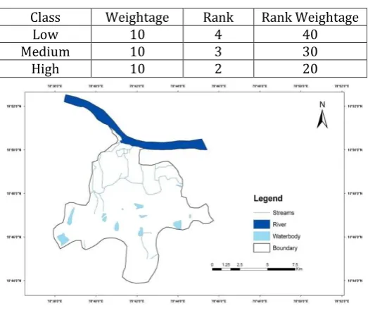
[image:3.595.41.292.400.611.2]watershed area.Drainage density is a measure of texture of drainage basin.(D ),L- total length of streams,A – area of drainage basin,Drainage density map is prepared by superimposing grid map with the help of arc map. The drainage density map has been classified into 4 types are as very high, high, medium and low depending upon their values of GIS map generation.
Table. 5. Drainage Density map
Class Weightage Rank Rank Weightage
Low 10 4 40
Medium 10 3 30
High 10 2 20
Figure.2.Drainage Density Map.
[image:4.595.30.294.527.593.2]4.2. SLOPE MAP:Slope map is classified into four classes to give the rank on the basis of making four classes of interval.
Table .6. Slope Map
Class Weightage Rank Rank Weightage
Low 10 4 40
Medium 10 3 30
High 10 1 10
Very high 10 1 10
4.3.WATER LEVEL MAP:
Water level map is classified into three classes to give the rank on the basis of making three classes of interval.
Table. 7.Water Level
Class Weightage Rank Rank Weightage 0-2.5
meters 10 1 10
2.5-5
meters 10 1 10
5-7.5
meters 10 1 30
4.4. GIS ANALYSIS:
After assigning suitable rank and weightage for all the thematic layers, overlay analysis is done using GIS software.
4.5. MODEL BUILDER:
In general terms, a model is a representation of reality. A model represents only those factors that are important to our work flow and creates a simplified, manageable view of the real world.In ArcGIS, a model is displayed as a model diagram. Building a model helps us to manage and automate our geo processing work flow. Managing processes and their supporting data can be difficult without the aid of a model. A sophisticated model contains a number of interrelated processes. At any time, we may add new processes, delete existing processes, or change the relationships between processes. We may also change assumptions or parameter values; for example, replace old datasets with newer ones, or consider alternative scenarios in which input factors are prioritized differently.The Model Builder window is the interface used to create models in Arc GIS. A model builder window is displayed immediately when we create a new model. The model builder window consists of a display window in which we build a diagram of our model, a Main menu, and a toolbar that we can use to interact with elements in our model diagram.By using the model builder we obtain the zonation map and suitable site for solid waste disposal is found.The site selected should be,20 Km away from town,20 Km away from drinking water, tank, reservoir,10 Km away from park (or) bird sanctuary,5 Km away from schools, temples, monuments.
4. CONCLUSION
The sites determined as suitable for landfill are confirmed with field checks and a detailed feasibility study should be carried out on the selected area and minimize all pollution risks with a view of environment protection.
Integration of various parameters through IRS- P6 LISS are taken for research.
Thus with the use of these technologies management of city will no longer be a problem for city administrators.
REFERENCES:
[1].Achi. H. A, Adeofun. C. O ,Ufoegbune. G.C , Gbadebo. A.M, &Oyedepo, (2012), “Disposal Sites and Transport Route Selection Using Geographic Information System and Remote Sensing in Abeokuta”, Nigeria.
[3].Anwar.S.M, (2004). Solid Waste Management and GIS: a Case of Kalabagan Area of Dhaka
[4]Arinola. A.G,&Arinola A.M (1995), “‘Solid waste in urban and rural areas of Ibadan”, Nigeria :composition, treatment and public health concerns, Compost science and utilization.
[5].Baloone.B and Alli.M, (2004). “Sampling Household Waste at Source: Lessons Learnt in Spain”.
[6].Basagagolu.H, Celenk.E, Marino.M.A, &Usul.N(1997), “Selection of waste disposal sites using GIS”. Journal of the American water resources association.
[7]Bylinsky, Gene (1989). "Managing With Electronic Maps," Fortune April 24, 237-254l.
[8]Chinamo.E.B.M, (2003). “An Overview of Solid Waste”Management and How Solid Waste City, Bangladesh, MSc. Dissertation, Department of Geography, Norwegian University of Collection Benefits the Poor in the City of Germany.
[9].Giza chewKabite, (2011), “GIS and remote sensing based solid waste landfill site selection: A case of Addis Ababa city”Addis Ababa university, Ethiopia.