Design and Implementation of a Voice Based Navigation for
Visually Impaired Persons
Jae Sung Cha, Dong Kyun Lim and Yong-Nyuo Shin
Dept. Of Computer Science, Hanyang Cyber University, Seoul,133-791, Korea
[email protected], [email protected], [email protected]
Abstract
As our society farther expands, there has been many supports for second-class citizens, disabled. One of many supports that is urgent is the guarantee of mobility for blind people. There has been many efforts but even now, it is not easy for blind people to independently move. In this paper, it constructs and materializes the navigation system for blind people in order to provide precise location information, using Android base Smart Phone. The navigation system uses TTS(Text-to-Speech) for blindness in order to provide a navigation service through voice. Also, it uses Google Map API to apply map information. Suggested system, as an independent program, is fairly cheap and it is possible to install onto Smart phone held by blind people. This allows blind people to easy excess the program. This application tested its performance through Galaxy Player YP-GB1 based on Android 2.2. As the result, the voice support about map information has progressed favorably.
Keywords: TTS, Visually Impaired Persons, Navigation System
1.
Introduction
As our society farther expands, there have been many supports for second-class citizens, disabled. One of many supports that is urgent is the guarantee of mobility for blind people. There has been many efforts but even now, it is not easy for blind people to independently move [1].
As electronic technologies have improved, a research about Electrical Aided: EA for blind people has started. With a current product, Human Tech of Japan developed Navigation for blind people, using GPS and cell phone. This system is consisted of cell phone of the user (blind people), a subminiature of GPS receiver, a magnetic direction sensor, a control unit and a speech synthesis equipment with PC of base station [2].
Also, this system is a Tag project that YRP Ubiquitous Networking Laboratory and Country traffic contributed. This system would be attached to a certain place rather than holding as an object, and provide supports for blind people. This system uses a method of attaching wireless information tag of IC method on baille block. These tags can be received by a cane with reading device. This system was tested by ITS(Intelligent Transfer System). It has a limited range due to IC method and a limited upgrade and double-way information sharing [3].
International Journal of Bio-Science and Bio-Technology Vol. 5, No. 3, June, 2013
vibration indicates the direction and the distance between the user and the obstacle. However, a longer usage of this product can make the user tired [4]. These existing products require a large amount of investment costs and a social infra has to be constructed. In this paper, a research of a navigation system for blind people is written in order to provide more precise location information. The application suggested in this paper uses TTS program and Google Maps APIs in order to provide navigation with voices This suggested system uses Smart Phone which is less tiring to use, and it is fairly cheap and provides an easier mobility.
2.
Related Technology
2.1 Android
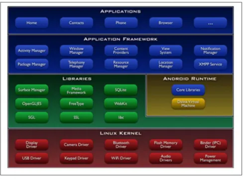
Android is a software stack and mobile operating system that includes the operating system for portable devices, middleware, user interface, and a standard application (Web Browser, Email Client, SMS), multimedia message service (MMS). Android developers were able to write applications in the Java language, a runtime library that can run the compiled byte code (Java Runtime Library). In addition, it provides the required application through the Android Software Development Kit (SDK) to develop a variety of tools and APIs. Android works on the Linux kernel and the Android system uses C / C + + libraries, etc. are included. Android, unlike existing Java virtual machines, uses an Java application made of Dalvik Virtual machine that runs on a separate process. In 2005, Google acquired Android Inc. and in November, 2007, Google announced to freely open Android platform to the public. After the announcement, 48 different hardware, software, and communication companies collaborated to design Open Handset Alliance, OHA and it has been developing an open-to-public standard. Google distributed all source code of Android as Apache v2 license so that companies or users can independently develop Android program. A construction of Android is shown in figure 1 as followed. In these construction components, it is divided into a total of 5 class of application, application framework, library, Android runtime, and Linux kernel. Handset layout platform is adaptive to expand 3D graphic library based on OpenGL ES1.0, VGA, and 2D graphic library, and it uses SQLite database software for a purpose of data storage. Android supports connection technologies including GSM/EDGE, CDMA, EV-DO, UMTS, Blue Tooth, and WiFi. It also supports a web browser based on an open source, Webkit application framework and it allows the usage of touch screen that is supported by additional hardware, GPS, acceleration sensor, compass sensor, and 3D graphic acceleration.
2.2 GPS(Global Positioning System)
GPS is a radio navigation system using satellites and it is developed by USA Department of Defense for military use navigation but it can be used by citizens with a limited range. It predicts radio coverage from satellites to a receiver, then it shows the exact 3D location, speed and time. This system can be universally used for 24 hours, and many people can use it. This GPS system can be dived into 3 different segments; SS (Space Segment), CS (Control Segment), and US (User Segment). SS (Space Segment) represents the location of 24 satellites that rotate around the Earth every 12 hours. As of April, 2007, there is a total of 36 GPS satellites with 30 of them are active and 6 of them are preparatory satellites in case of malfunction. CS (Control Segment) represents a general observation post that manages and tracks GPS satellites. US (User Segment) represents GPS users and GPS receiver [2].
Figure 1. Construction of Android
2.3 LBS(Location-Based System)
LBS service indicates a wireless contents service that provides certain information based on the location change of the user. Developers of mobile handset have voluntarily tried to install LBS within their devices. However, LBS was originally developed by telecommunication companies nd mobile contents providers. Main benefit of the system is the fact that the users don’t have to directly insert location as they move. GPS positioning technology is one of important technologies that allows easier excess of wireless internet service. However, in order to materlize LBS, there are more related technologies other than GPS and satellite based technologies. Within mobile communication network, there exists a management mechanism in order to manage a mobility of cell phone and there are many GPS LBS service based on the mechanism. Movements of LBS can be seen in three different parts; Positioning technology, lay-administered platform and location application.
1) Positioning Technology: Service provider can predict any location using GPS chip within wireless device. In this case, the positioning technology directly manages a calculation of location using received signal from satellite. Once the calculation is done, a variety of information can be received through mobile communication network. Depending on Mobile communication network or location information service, the system sometimes uses a single base station based information, rather than multiple base stations. Since mobile communication network, characteristically, constantly manages the mobility of cell phones, this positioning technology method can be a method of providing LBS without any additional position technology and any calculation from requests of location. The accuracy of location estimation is at the maximum when the location was estimated using GPS and the matching
International Journal of Bio-Science and Bio-Technology Vol. 5, No. 3, June, 2013
rather than a coordinate. LBL service can be materialized using other methods other than what are currently shown. Within current mobile communication network, there exists a variety of end terminals that have different method of predicting location. Therefore, normal mobile communication companies combines GPS, A-GPS and a base station based method to provide LBS.
2) Lay-administered Platform: A lay-administered platform is a general word for LBs service components that achieves and process user location from position technology and provides information to application through an interface with network. Within network models based on GSM, CDMA, GMLC(Gateway Mobile Location Center) has been defined as a facility that request a base station based routing information by interlocking with management system in the inner part of mobile communication service and functions as a gateway of interlocking with LBS application within IP network. These GMLC can be sorted out to be one of LBS platforms within mobile communication network.
3) Location application: This application represents a service that provides already processed contents based on locations of individual user or an object through communicating with lay-administered platform or that can manage collected location information.
Within mobile communication network, this application can be separated into Location Application server and Location contents server. Location Application Server is nicknamed as ‘LBs Platform’ and it is a facility of mobile communication network that simultaneously provides extra service based on basic location and a gateway for the outer contents service. Typical contents service or areas of solution are telematics, WAP service based on location, emergent safety call service, map combined with GIS and a region service [3].
3. Navigation System
3.1. Service Composition.
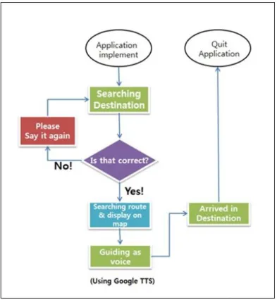
The application developed in this paper functions through voices. Smart Phone recognizes the voices, search for destination, routes, and provide the route to the user through voice. Figure 2 shows a hierarchy of service progression.
The functions of the application developed in this paper are as followed. The first function is to search destination through voice recognition and Google TTS service. After pressing ‘search’ button, users say the wanted destination according to the instruction. In case of unclear voice, the message saying ‘speak once more’ will pop up and users say the destination once more clearly. If the application asks for confirmation of destination, the users say, ‘yes’, if the destination is correct.
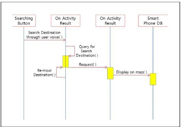
The second function is route research using Google Map. After users have confirmed the destination, the application materializes the map after searching for route from the current location of the user to the destination. Figure 3 below is about request of map information.
The third function is to guide the users with voice. Using DB of Smart Phone, it sees the route to the destination and it begins to guide by saying travel range, and direction for each section of the route. Figure 4 shows the diagram of program action.
Figure 2. Hierarchy of Progression
International Journal of Bio-Science and Bio-Technology Vol. 5, No. 3, June, 2013
Figure 4. The Diagram of program action
3.2. Implementation and Results
The result of materialization is as followed. The ‘favorite’ button and ‘search’ button in order to provide search service by pushing ‘search’ button and saving the destination by pushing ‘favorite’ button for future reference.
Figure 5 shows the beginning Screen of Program. When users push ‘search’ button, it shows the screen for users to say the destination like shown in figure 6 below and the users say the destination.
After saying the wanted destination and confirming it by saying yes, when the application asked, the application notify the users by a screen that says searching and voice-alarm saying it will search for the destination.
Figure 7 shows the screen of finding the destination. After the search has been finished, it marks the route from the position of the users and the destination on maps saved in Smart Phone DB. When the destination was incorrectly said or accepted, the message saying, “no matching data” comes up on the screen, and the users simply push ‘speak again’ button to say the destination correctly.
After the route has been completely shown on the map, the application can guide the users after the users have pressed setting button on the device.
Figure 5. Beginning Screen of Program Figure 6. Search Keyword Screen
Figure 7. Destination searching screen Figure 8. Voice Navigation Screen
4. Conclusion
In this paper, it designed and materialized a navigation system for blind people in order to provide precise location information. Suggested system, as an independent program, is fairly cheap and it is possible to install onto Smart phone held by blind people. This allows blind people to easy excess the program. The developed service utilized Smart Phone DB in order to search route between the current location of user to the destination and provide a voice-navigation.
The test of the application functions were done on Galaxy Player YP-GB1 by using Android 2.2. As the result, voice support on route was successfully proven to work without any troubles. Further researches have to be continued in order to provide the users using Mapping, extra function materializations on buttons, and materialization on other software other than OS (iOS and others) it constructs and materializes a voice-based navigation application for blindness, using Android base Smart Phone. The navigation system uses
International Journal of Bio-Science and Bio-Technology Vol. 5, No. 3, June, 2013
References
[1] C. Kang, H. Jo and B. Kim, “A Machine-to-Machine based Intelligent Walking Assistance System for Visually Impaired Person”, The Journal of KICS, vol. 36, no. 3, (2011), pp. 195-304.
[2] S. Kumar, M. A. Qadeer and A. Aupta, “Location Based Service using Android”, Internet Multimedia Service Architecture and Applications, IEEE international Conference, (2009).
[3] H. -W. Jung, “Samrtphones and future changes”, The Korea Contents Association, vol. 8, no. 2, (2010). [4] i. -H. O, J. S. Bae, D. -W. Park and Y. -H. Sohn, “Implementation of Location Based Service(LBS) using
GPS for Various Sizes of Maps”, Korean Institute of Information Technology, vol. 8, no. 4, (2010).
[5] G. E. Lee and J. W. Lee, “Google Android phone Personal open market”, Korean Multimedia Society, Fall Conference, (2009), pp. 346-349.
[6] G. Broll, S. Keck, P. Holleis and A. Butz, “Improving the Accessibility of NFC/RFID-based Mobile Interaction through Learnability and Guidance”, International Conference on Human-Computer Interaction with mobile devices and services, vol. 11, (2009).
[7] S.-Y. Kim, B. Park and J. -J. Jung, “User Route analysis of using GPS on a Mobile Device and Moving Route Recommendation System”, The Korea Contents Associations, vol. 11, no. 2, (2011).
[8] H. -O. Kwon, T. -H. Lee and K. -S. Hong, “Location Based Semantic Information Retrieval System in a Mobile Environment”, Korean Society for Internet Information, Fall Conference, (2009), pp. 311-336. [9] S. Chiti and B. Leporini, “Accessibility of Android-Based Mobile Devices: A Prototype to investigation
Interaction with Blind Users”, Lecture Notes in Computer Science, vol. 7383, (2012).
[10] N. Markus, S. Malik, Z. Juhasz and A. Arato, “Accessibility for the Blind on an Open-Source Mobile Platform: Mobile Slate Talker(MOST) for Android”, Lecture Notes in Computer Science, vol. 7383, (2012).
Authors
Jae Sung ChaHe received the Bachelor of Engineering degree in Department of Computer Science, Hangyang Cyber University in 2008, Republic of Korea. Currently, he is a he is a Researcher at QoLT Industrial Infrastructure Development Center. Also, His current research interests are Android system and Web accessibility.
Dong Kyun Lim
He received the PhD degree in Electronic Communication from Hanyang University in 2008, Republic of Korea. Currently, he is a professor at Department of Computer Science, Hangyang Cyber University. Also, His current research interests are computer education, e-Learning.
Yong-Nyuo Shin
She received the PhD degree in computer science from Korea University in 2008, Republic of Korea. Currently, she is a professor at Department of Computer Science, Hangyang Cyber University. Also, she is an editor for efforts and continued support in progressing the many standardizations such as ITU-T SG17, ISO/IEC JTC1 SC27 and SC37. Her current research interests are telebiometrics, authentication technologies and privacy (Corresponding author of this paper).