Reasoning with Place Information on the Linked Data Web
Alia I Abdelmoty, Khalid M. Al-Muzaini
Cardiff School of Computer Science & InformaticsCardiff University Wales, UK
Email:{A.I.Abdelmoty, Almuzainiko}@cs.cf.ac.uk Abstract—The Linked Data Web (LDW) is an evolution of
the traditional Web from a global information space of linked documents to one where both documents and data are linked. A significant amount of geographic information about places are currently being published on this LDW. These are used to qualify the location of other types of datasets. This paper examines the limitations in the nature of location representation in some typical examples of these Resource Description Framework (RDF) resources, primarily resulting from the simplified geometric representation of location and the incomplete and random use of spatial relationships to link place information. The paper proposes a qualitative model of place location that enforces an ordered representation of relative spatial relationships between places. The model facilitates the application of qualitative spatial reasoning on places to extract a potentially large percentage of implicit links between place resources, thus allowing place information to be linked and to be explored more fully and more consistently than what is currently possible. The paper describes the model and presents experimental results demonstrating the effectiveness of the model on realistic examples of geospatial RDF resources.
Keywords–qualitative place models; spatial reasoning; geospa-tial web.
I. INTRODUCTION
One of the ‘Linked Data Principles’[1] is to include links to connect the data to allow the discovery of related things. However, identifying links between data items remains a considerable challenge that needs to be addressed [2]. A key research task in this respect is identity resolution, i.e., to recognise when two things denoted by two URIs are the same and when they are not. Automatic linking can easily create inadequate links, and manual linking is often too time consuming [3]. Geo-referencing data on the LDW can address this problem [4], whereby links can be inferred between data items by tracing their spatial (and temporal) footprints. For example, the BBC uses RDF place gazetteers as an anchor to relate information on weather, travel and local news [5].
Yet, for geospatial linked data to serve its purpose, links within and amongst the geographic RDF resources need them-selves to be resolved. That is to allow place resources to be uniquely identified and thus a place description in one dataset can be matched to another describing the same place in a different dataset. A scheme that allows such links between place resources to be discovered would be a valuable step towards the realisation of the LDW as a whole.
In this paper, location is used as a key identifier for place resources and the question to be addressed is how location can be used to define a linkedplace model that is sufficient to
enable place resources to be uniquely identified on the LDW. Several challenges need to be addressed, namely, 1) location representation of RDF place resources is simple; defined as point coordinates in some resources, detailed; defined with extended geometries in others, and sometimes missing all together, 2) coordinates of locations may not match exactly across data sources, where volunteered data mapped by in-dividuals is mashed up with authoritative map datasets, 3) non-standardised vocabularies for expressing relative location is used in most datasets, e.g., in DBpedia, properties such as dbp:location,dbp-ont:regionanddbp-ont:principalareaare used to indicate that the subject place lies inside the object place.
Towards addressing this problem, a linked place model is proposed that uses qualitative spatial relationships to describe unique place location profiles. The profiles don’t rely on the provision of exact geometries and hence can be used homogeneously with different types of place resources. They can be expressed as RDF statements and can thus be integrated directly with the resource descriptions. The rationale behind the choice of links to be modelled is primarily twofold: to allow for a sensible unique description of place location and to support qualitative spatial reasoning over place resources. The value of the linked place model is illustrated by measuring its ability to make the underlying RDF graph of geographic place resources browsable. Samples of realistic geographic linked datasets are used in the experiments presented and results demonstrate significant potential value of the methods proposed.
The paper is structured as follows. An overview of related work on the representation and manipulation of place resources on the LDW is given in section II, In section III the proposed relative location model is presented and in section IV, its application on two different realistic datasets is evaluated. Conclusions and an overview of future work is given in section V.
II. RELATEDWORK
Here related work on the topics of representing place resources and reasoning with them on the LDW are reviewed. A. Representing RDF place Resources on the LDW
Sources of geographic data on the LDW are either vol-unteered (crowdsourced) resources, henceforth denoted Vol-unteered Geographic Information (VGI), created by indi-viduals with only informal procedures for validating the content, or authoritative resources produced by mapping
organizations, henceforth denoted Authoritative Geographic Information (AGI). Example of VGIs are DBpedia (db-pedia.org), GeoNames (geonames.org), and OpenSreetMaps (linkedgeodata.org)[6] and examples of AGIs are the Ordnance Survey linked data [7] and the Spanish linked data [8].
The volume of VGI resources is increasing steadily, provid-ing a wealth of information on geographic places and creatprovid-ing detailed maps of the world. DBpedia contains hundreds of thousands of place entities, whose locations are represented as point geometry. GeoNames is a gazetteer that collects both spatial and thematic information for various place names around the world. In both datasets, place location is repre-sented by a single point coordinates. While DBpedia does not enforce any constraints on the definition of place location (e.g., coordinates may be missing in place resources), reference to some relative spatial relationships, and in particular to represent containment within a geographic region, is normally maintained. GeoNames places are also interlinked with each other by defining associated parent places.
In [9], the LinkedGeoData effort is described where OSM data is transformed into RDF and made available on the Web. OSM data is represented with a relatively simple data model that captures the underlying geometry of the features. It comprises three basic types, nodes (representing points on Earth and have longitude and latitude values), ways (ordered sequences of nodes that form a polyline or a polygon) and relations (groupings of multiple nodes and/or ways). Further-more, [10] presented methods to determine links between map features in OSM and equivalent instances documented in DBpedia, as well as between OSM and Geonames. Their matching is based on a combination of the Jaro-Winkler string distance between the text of the respective place names and the geographic distance between the entities. Example of other work on linking geodata on the Semantic Web is [11], which employs the Hausdorff distance to establish similarity between spatially extensive linear or polygonal features.
In contrast to VGI resources that manages geographic resource as points (represented by a coordinate of latitude and longitude), AGI resources deal with more complex geometries as well, such as line strings. AGIs tend to utilise well-defined standards and ontologies for representing geographic features and geometries. Ordnance Survey linked data also demonstrates the use of qualitative spatial relations to describe spatial relationships in its datasets. Two ontologies, the Ge-ometry Ontology and the Spatial Relations Ontology, are used to provide geospatial vocabulary. These ontologies describe abstract geometries and topological relations (equivalent to RCC8 [12]) respectively.
In summary, the spatial representation of place resources in VGI datasets is generally limited to point representation, and is managed within simple ontologies that encode non-spatial semantics and in some cases limited spatial relationships. On the other hand, place data provided as AGI tend to present more structured and detailed spatial representations, but is also limited to specific types and scales of representation. Use of some qualitative spatial relationships has been demonstrated for capturing the spatial structure in some example datasets. The model proposed in this paper offers a systematic and homogenous representation of place location that can be con-sistently applied to VGIs or AGIs and demonstrates the value of heterogenous qualitative spatial relations in representing
place information on the LDW.
B. Manipulating and Querying RDF place resources on the LDW
Recently, much work has been done on extending RDF for representing geospatial information through defining and utilising appropriate vocabularies encoded in ontologies to represent space and time. The work capitalises on specification of standards, defined by the Open Geospatial Consortium (OGC)(opengeospatial.org), for modeling core concepts related to geospatial data. Prominent examples are GeoSPARQL, an OGC standard [13] and stRDF/stSPARQL [14]. Both proposals provide vocabulary (classes, properties, and functions) that can be used in RDF graphs and SPARQL queries to represent and query geospatial data, for example geo:SpatialObject, which has as instances everything that can have a spatial representation and geo:Geometry as the superclass of all geometry classes. In addition, geometric functions and topo-logical functions are offered for performing computations, such as geof:distance and for asserting topological relations between spatial objects, e.g., dbpedia:Cardiff geo:sfWithin dbpedia:Wales.
Qualitative spatial representation and reasoning (QSRR) are established areas of research [15], whose results have influenced the definition of models of spatial relationships in international standards, e.g., the OGC models, and commercial spatial database systems (for example, in the Oracle DB system). RCC8, a QSRR model, has been recently adopted by GeoSPARQL [13], and there is an ever increasing interest in coupling QSR techniques with Linked Geospatial Data that are constantly being made available [14]. On the other hand, Semantic Web reasoning engines have been extended to support qualitative spatial relations, e.g., Racerpro [16] and PelletSpatial [17]. Scalability of the spatial reasoning is recognised and reported challenge. Scalable implementations of constraint network algorithms for qualitative and quantita-tive spatial constraints are needed, as RDF stores supporting Linked Geospatial Data are expected to scale to billions of triples [14]. Lately, promising results have been reported by [18], who proposed an approach for removing redundancy in RCC8 networks and by [19], who examined graph-partitioning techniques as a method for coping with large networks; in both cases leading to more effective application of spatial rea-soning mechanisms. Finally, qualitative methods were used to complement existing quantitative methods for representing the geometry of spatial locations. In [20], heterogenous reasoning methods are proposed that combine calls between a spatial database system and a spatial reasoning engine implemented in OWL2 RL to check the consistency of place ontologies. In [21], Younis et al described query plans that make use of a combination of qualitative spatial relationships associated with place resources in DBpedia and detailed representations of geometry maintained in a spatially indexed database for answering complex queries. In both cases, qualitative reason-ing was limited by the fragmented and scarce availability of spatial relationships to work on. The qualitative scheme of representation of place location proposed in this paper addresses this issue and provides a novel method for defining spatial relationships that is designed to support and facilitate the effective use of qualitative spatial reasoning on the LDW.
III. A LINKEDPLACEMODEL FOR THELINKEDDATA WEB
A Relative Location model (RelLoc) is proposed here to capture a qualitative representation of the spatial structure of place location. Two types of spatial relations are used as follows.
1) Containment relationships, to record that a parent place directly contains a child place; i.e., one step hierarchy. For example, for three places representing a district, a city and a country, the model will explic-itly record the relationships: inside(district, city) and inside(city, country), but not inside(district, country). 2) Direction-proximity relationships, to record for every place the relative direction location of its nearest neighbour places. The direction frame of reference can be selected as appropriate. For example, for a 4-cardinal direction frame of reference, a place will record its relative direction relation with its nearest neighbour in four directions.
For a given set of places P l, let DirP r be the set of all direction-proximity relations between instances of places inP l
as defined above, and let Conbe the set of containment rela-tions between instances of places inP las defined above. Then,
RelLoc(P l)is defined as a tupleRelLoc(P l) := (P l, D, C), where:D∈DirP randC∈Con.Rnn(x, y)is used to denote that xis the nearest neighbour from the directionRto object
y. For example,Nnn(pl1, pl2)indicates that pl1is the nearest neighbour from the north direction to pl2, etc.
To illustrate the model, consider the scene in Figure 1 that consists of a set of places,atof, with a 4-cardinal direction frame of reference overlaid for some places in the scenes. A representative point is used to define the place location. It is further known that places represented as points a, b, c, e
are inside d and places d, f are inside g. The full set of relationships used to model the scene are given in the table in Figure 1(b). Note that in some cases, no relation can be found, e.g., there are no neighbours for objectcfrom the west direction in Figure 1(a).
A. Spatial Reasoning with the Relative Location Model We can reason over the relative location model to in-fer more of the implicit spatial structure of place location. Qualitative spatial reasoning (QSR) tools can be utilised to propagate the defined relationships and derive new ones between places in the scene. QSR takes advantage of the transitive nature of the partial or total ordering of the quan-tity space in order to infer new information from the raw information presented. In particular, the transitive nature of some spatial relationships can be used to directly infer spatial hierarchies, for example, containment and cardinal direction relations. The scope of the model is deliberately focussed on general containment relationships and ignores other pos-sible topological relations, such as overlap or touch. Hence, building containment hierarchies is straightforward using the transitivity rules: inside(a, b)∧inside(b, c) → inside(a, c) andcontains(a, b)∧contains(b, c)→contains(a, c).
In the case of direction relationships, more detailed spatial reasoning can be applied using composition tables. Table I shows the composition table for a 4-cardinal direction frame of reference between point representations of spatial objects.
(a)
Set of spatial relations to model relative location
Nnn(d, a),Snn(b, a),Wnn(c, a),Enn(e, a) Nnn(g, d),Snn(a, d),Wnn(c, d),Enn(e, d) Nnn(g, c),Snn(b, c),Enn(a, c) Nnn(a, b),Enn(f, b) Nnn(a, f),Wnn(b, f) Nnn(g, e),Snn(b, e),Wnn(d, e) Snn(d, g) in(a, d),in(b, d),in(c, d),in(e, d), in(d, g),in(f, g) (b)
Figure 1. (a) An example map scene with a set of places represented as points.(b) Set of direction, proximity and containment relations chosen to
representative relative location in the proposed model.
TABLE I. COMPOSITION TABLE FOR 4-CARDINAL DIRECTION RELATIONSHIPS. N E S W N N N∨E All N∨W E N∨E E S∨E All S All S∨E S S∨W W W∨N All W∨S W
In considering the entries of the composition tables, some of those entries provide definite conclusions of the composition operation, i.e., the composition result is only one relationship (emboldened in table), other entries are indefinite and result in a disjunctive set of possible relationships, e.g., the compo-sition: N(a, b)∧E(b, c)→N(a, c)∨E(a, c).
Spatial reasoning can be applied on the linked place model using different strategies. The most straightforward is through deriving the algebraic closure, i.e., completing the scene by deriving all possible missing relationships between objects. Path-consistency algorithms for deriving the algebraic closure has been been implemented in various tools, e.g., in the SparQ spatial reasoning engine [22]. Table II shows the result of this operation for the example scene in Figure 1. Explicit relations are shown in bold and the remaining relation are inferred by spatial reasoning. As can be seen in the table, using the 19 relationships defined for the model in Figure 1(b), reasoning was able to derive a further 19 definite relationships, completing over90% of the possible relations in the scene.
TABLE II. RESULT OF REASONING WITH CARDINAL RELATIONS FOR THE PLACE MODEL IN FIGURE 1.
a b c d e f g a - N E S W N S b S - S S S W S c W W - W W N∨W S∨W d N N E - W N S e E N E E - N S f S E S∨E S S - S g N N N N N N
-B. Applying the Relative Location Place Model on the LDW The underlying structure of any expression in RDF is a collection of triples, each consisting of a subject, a predicate and an object. A set of such triples is called an RDF graph, in which each triple is represented as a node-arc-node link and each triple represents a statement of a relationship between the subjects and objects, denoted by the nodes, that it links. The meaning of an RDF graph is the conjunction (logical AND) of the statements corresponding to all the triples it contains.
The RelLoc place model can be interpreted as a simple connected graph with nodes representing place resources and edges representing the spatial relationships between places. Thus a realisation of the place model for a specific RDF document of place resources is a subgraph of the RDF graph of the document. TheRelLocRDF graph is completely defined if RDF statements are used to represent all spatial relationships defined in the model, e.g., for the scene in Figure 1, 25 RDF statements are needed to encode the cardinal (19) and containment (6) relationships in the table in Figure 1(b).
Let P l be a finite set of place class resources defined in an RDF data store and DirP r(P l)defines cardinal direction relations between members of P landCon(P l) describes the containment relations between members of P l as defined by the relative location model above.
ARelLoc subgraphGL= (VL, EL)is a simple connected
graph that models P l, where: VL = P l is the set of nodes,
EL ={DirP r(P l)∪Con(P l)} is the set of edges labelled with the corresponding direction and containment relation-ships.
Note that there exists a subgraph of GL for every place pl ∈ P l, which represents the subset of direction-proximity and containment relationships that completely define the rela-tive location ofpl. Thus, alocation profilefor a particular place
pl ∈P l can be defined as Lpl={(DirP rpl, Conpl}.Lpl is
the restriction of Ltopl, whereDirP rpl andConpl defines
direction proximity and containment relations respectively betweenpland other places inP l, as specified by our model. For example the location profile for place a in Fig-ure 1 is the set of statements describing the relations:
N(d, a), S(b, a), W(c, a), E(e, a), in(a, d).
TheRelLocgraph can be represented by a matrix to register the adjacency relationship between the place and its nearest neighbours. The scene in Figure 1 is shown as a graph with nodes and edges in Figure 2(a) and its corresponding adjacency matrix is shown in (b). The fact that two places are neighbours is represented by a value (1) in the matrix and by a value (0) otherwise. Values of (1) in the matrix can be replaced by the relative orientation relationship between the corresponding
(a) a b c d e f g a - 1 1 1 1 0 0 b 1 - 0 0 0 1 0 c 1 1 - 0 0 0 1 d 1 0 1 - 1 0 1 e 0 1 0 1 - 0 1 f 1 1 0 0 0 - 0 g 0 0 0 1 0 0 -(b) a b c d e f g a - N E S 0 N 0 b S - S 0 S W 0 c W 0 - W 0 0 0 d N 0 0 - W 0 N e E 0 0 E - 0 0 f 0 E 0 0 0 - 0 g 0 0 N N N 0 -(c)
Figure 2. (a) A graph representing the sample map scene from Figure 1. (b) Adjacency matrix for the location graph representing nearest neighbour
relationships. (c) Adjacency-orientation matrix representing nearest neighbour and direction relationships.
places as shown in Figure 2(c) and the resulting structure is denoted Adjacency-Orientation Matrix.
IV. APPLICATION ANDEVALUATION
The main goals of the Linked Place model is to provide a representation of place location on the LDW that allows for place information to be linked effectively and consistently. The effectiveness of the proposed model can be evaluated with respect to two main aspects; whether it provides a sound definition of place location, that is to test the correctness of the place location profiles, and whether it provides a complete definition of place location, that is whether acompleterelative location graph can be derived using the individual place location profiles.
The soundness of the location profiles is assumed as it essentially relies on the validity of the computation of the spatial relationships. Issues related to the complexity of this process are discussed in the next section.
Here, we evaluate the completeness aspect of the model. An individual place location profile defined using the model
Figure 3. Components of the developed system to implement the linked place model.
prefix d: <http://dbpedia.org/ontology/> prefix :<http://dbpedia.org/resource/> prefix prop: <http://dbpedia.org/property/>
prefix geo: <http://www.w3.org/2003/01/geo/wgs84_pos#> select ?place (MAX(?lat) as ?lat)(MAX(?long) as ?long) where{
?place ?ontology ?resource. ?place a d:Place.
?place geo:lat ?lat. ?place geo:long ?long.
filter ( ?resource = :Wales or ?resource = "Wales"@en ) }
group by ?place order by ?place
Figure 4. SparQL query used to extract place data from DBpedia.
represents a finite set of spatial relationships between a place and its nearest neighbours and direct parent. Completeness of the model can be defined as the degree to which these individ-ual profiles can be used to derive implicit links between places not defined by the model. The model is entirely complete if a full set of links between places can be derived using automatic spatial reasoning, i.e., the model can produce a complete graph, where there is a defined spatial relationship between every place in the dataset and every other place.
A system was developed that implements the Linked Place model and further builds an enriched model using spatial reasoning for evaluation purposes as shown in Figure 3. Two datasets were used in this experiment, DBPedia and the Ordnance Survey open data [7]. These were chosen as they exhibit different representations of place resources on the LDW and are typical of VGIs and AGIs respectively. A description of the datasets used is presented below, along with the results of the application of spatial reasoning over the constructed linked place models.
DBpedia DataSet
A sample dataset containing all Places in Wales, UK, has been downloaded from DBpedia using the sparQL query in Figure 4.
A total of 489 places were used, for which a relative location graph of2751direction-proximity relations was con-structed. Completing the graph resulted in116403total number of relations, out of which50340relations are definite (defining only one possible relationship).
Note that of the indefinite relationships some are a dis-junction of 2 relations, e.g., {N, N W} or {E, SE} and some are a disjunction of3 relations, e.g.,{N, N E, N W}or {N E, E, SE}. In both cases, relations can be generalised to a “coarser” direction relation, for example,{N E, E, SE}can be generalised to general Eastrelationship. These results are considered useful and thus are filtered out in the presentation.
TABLE III. RESULTS OF REASONING APPLIED ON THE DBPEDIA DATASET.
Defined Definite 2-Relations 3-Relations Others
2751 50340 63148 28 136
2.36% 43.24% 54.22% 0.02% 0.12%
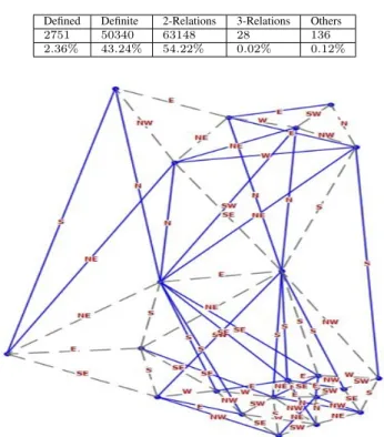
Figure 5. (a) Linked Place Graph for the Unitary Authorities in Wales from the Ordnance Survey dataset.
The remaining results are disjunctions of unrelated directions, e.g.,{N, N E, E}, and are thus considered to be ambiguous. A summary of the results is shown in table III. Using the Linked Place model we are able to describe nearly half the possible relations precisely (45.6%), as well as almost all of the rest of the scene (54.22%) with some useful generalised direction relations.
Ordnance Survey DataSet
The Boundary-line RDF dataset for Wales was downloaded from the Ordnance Survey open data web site [7]. The data gives a range of local government administrative and electoral boundaries.
Figure 5 shows the relative location graph constructed for the Unitary Authority dataset for Wales. Dashed edges are used to indicate that relationships (and inverses) are defined both ways between the respective nodes, but only one relation is used to label the edge in the Linked Place model. The set contains22regions, for which 73 direction-proximity relations were computed. Reasoning applied on this set of relations produces the results shown in Table IV.
We can use the above results to describe the effectiveness
TABLE IV. RESULTS OF REASONING APPLIED ON THE ORDNANCE SURVEY DATASET.
Defined Definite 2-Relations 3-Relations Others
73 94 64 0 0
TABLE V. SUMMARY OF THE EXPERIMENT RESULTS. Def ined Def inite Def ined U sef ul DBpedia 0.054 0.024 OS 0.78 0.32
of the linked place model in terms of the information content it was able to deduce using the ratio of the number of defined relations to the number of deduced relations. A summary is presented in table V.
V. DISCUSSION ANDCONCLUSIONS
Data on geographic places are considered to be very useful on the LDW. Individuals and organisations are volunteering data to build global base maps enriched with different types of traditional and non-traditional semantics reflecting people’s views of geographic space and place. In addition, geographic references to place can be used to link different types of datasets, thus enhancing the utility of these datasets on the LDW. This work explores the challenges introduced when representing place data using the simple model of RDF, with different geometries to represent location and different non-standardised vocabularies to represent spatial relationships between locations.
A linked place model is proposed that injects certain types of spatial semantics into the RDF graph underlying the place data. Specific types of spatial relationships between place nodes are added to the graph to allow the creation of individual place location profiles that fully describe the relative spatial location of a place. It is further shown how the enriched relative location graph can allow spatial reasoning to be applied to derive implicit spatial links to produce even more richer place descriptions.
The results obtained from the initial evaluation experiments demonstrate possible significant value in the proposed model. Further work need to be done to explore the potential utility of the proposal. Some of the interesting issues that we aim to explore in the future are described below.
• Simple methods and assumptions were used to com-pute the direction relationships between places. Fur-ther study need to be carried out to evaluate wheFur-ther more involved representations are useful.
• No distinction between the types of place nodes are made when creating the graph. Can place semantics be utilised to guide this process further?
• Applications of spatial reasoning need to be consid-ered further. Describing the complete graph is not a practical (nor a useful) option. Can spatial reasoning be selectively applied, for example, as part of query processing on the location graph.
• Further evaluation is required to understand the scal-ability of the proposals to much larger RDF triple stores.
REFERENCES
[1] T. Berners-Lee. Linked data. http://www.w3.org/DesignIssues/ LinkedData.html. Accessed: 2009-12-15.
[2] C. Bizer, T. Heath, and T. Berners-Lee, “Linked data - the story so far,”International Journal on Semantic Web and Information Systems, vol. 5, no. 3, pp. 1–22, 2009.
[3] J. Goodwin, C. Dolbear, and G. Hart, “Geographical linked data: The administrative geography of great britain on the semantic web,” Transactions in GIS, vol. 12, pp. 19–30, 2008.
[4] G. Hart and C. Dolbear,Linked Data: A Geographic Perspective. CRC Books, 2013.
[5] C. Henden, P. Rissen, and S. Angeletou. Linked geospatial data, and the bbc. http://www.w3.org/2014/03/lgd/papers/lgd14 submission 28. Accessed: 2009-12-15.
[6] M. Hackley, “How good is volunteered geographical information? a comparative study of openstreetmap and ordnance survey datasets,” Environment and Planning B, vol. 37, no. 4, pp. 682–703, 2010. [7] Ordnance survey linked data platform. http://data.ordnancesurvey.co.
uk/. Accessed: 2009-12-15.
[8] Geolinkeddata.es. http://geo.linkeddata.es/. Accessed: 2009-12-15. [9] S. Auer, J. Lehmann, and S. Hellmann, “Linkedgeodata- adding a spatial
dimension to the web of data,” inProc. of 7th International Semantic Web Conference (ISWC), vol. LNCS 5823. Springer, 2009, pp. 731– 746.
[10] C. Stadler, J. Lehmann, K. Hffner, and S. Auer, “Linkedgeodata: A core for a web of spatial open data,”Semantic Web Journal, vol. 3, no. 4, pp. 333–354, 2012.
[11] J. Salas and A. Harth, “Finding spatial equivalences accross multiple rdf datasets,” inTerra Cognita Workshop,co-located with ISWC, R. Grtter, D. Kolas, M. Koubarakis, and D. Pfoser, Eds., 2011, pp. 114–126. [12] A. Cohn, B. Bennett, J. Gooday, and N. Gotts, “Qualitative spatial
representation and reasoning with the region connection calculus,” Geoinformatica, vol. 1, pp. 1–44, 1997.
[13] Geosparql - a geographic query language for rdf data. http://www. opengeospatial.org/standards/geosparql. Accessed: 2009-12-15. [14] M. Koubarakis, M. Karpathiotakis, K. Kyzirakos, C. Nikolaou, and
M. Sioutis, “Data Models and Query Languages for Linked Geospatial Data,” inReasoning Web. Semantic Technologies for Advanced Query Answering,Invited tutorial at the 8th Reasoning Web Summer School 2012 (RW 2012), T. Eiter and T. Krennwallner, Eds., vol. LNCS 7487. Springer, 2012, pp. 290–328.
[15] A. G. Cohn and J. Renz, Qualitative Spatial Representation and Reasoning, ser. Handbook of Knowledge Representation. Elsevier, 2008, pp. 551–596.
[16] What is racerpro. http://www1.racer-systems.com/products/racerpro/ index.phtml. Accessed: 2009-12-15.
[17] M. Stocker and E. Sirin, “Pelletspatial: A hybrid rcc-8 and rdf/owl reasoning and query engine,” in 6th Intern. Workshop on OWL: Ex-periences and Directions (OWLED2009). Springer-Verlag, 2009, pp. 2–31.
[18] M. Sioutis, S. Li, and J.-F. Condotta, “On redundancy in linked geospatial data,” in 2nd Workshop on Linked Data Quality (LDQ), ser. CEUR Workshop Proceedings, A. Rula, A. Zaveri, M. Knuth, and D. Kontokostas, Eds., no. 1376, 2015. [Online]. Available: http://ceur-ws.org/Vol-1376/#paper-05
[19] C. Nikolaou and M. Koubarakis, “Fast consistency checking of very large real-world rcc-8 constraint networks using graph partitioning,” inProceedings of the 28th AAAI Conference on Artificial Intelligence, 2014, pp. 2724–2730.
[20] A. Abdelmoty, P. Smart, and B. El-Geresy, “Spatial reasoning with place information on the semantic web,” International Journal on Artificial Intelligence Tools, vol. 23, no. 5, p. 1450011, 2014.
[21] E. Younis, C. Jones, V. Tanasescu, and A. Abdelmoty, “Hybrid geo-spatial query methods on the semantic web with a geo-spatially-enhanced index of dbpedia,” in Geographic Information Science, ser. Lecture Notes in Computer Science, N. Xiao, M.-P. Kwan, M. Goodchild, and S. Shekhar, Eds., vol. 7478. Springer Berlin Heidelberg, 2012, pp. 340–353.
[22] D. Wolter and J. Wallgrn, “Qualitative spatial reasoning for applications: New challenges and the sparq toolbox,” inQualitative Spatio-Temporal Representation and Reasoning: Trends and Future Directions, S. Haz-arika, Ed., 2012, pp. 336–362.