The classification is a prerequisite, a principal means of communication in all sciences and, with in-creasing knowledge, it needs to be revised regularly (Ahrens et al. 2003; Bouma 2003; Buol 2003).
Taxonomic systems have been developed specifi-cally for the communication between scientists. Pragmatic, special-purpose systems developed for the technical communication often have a low efficiency and with further development tend to become quickly outdated (Kellog 1974; Blum & Laker 2003).
The Taxonomic Soil Classification System of the Czech Republic (TKSP CR), dealt with mainly by Němeček and Kozák (2001), Němeček et al. (2001), Vokoun et al. (2003), allows a unified clas-sification of agricultural and forest soils. It is a hi-erarchical system which, in keeping with the world development, distinguishes the parent materials, diagnostic horizons, and soil properties. A signifi-cant advantage is its comparability with the World Reference Base (WRB), an international reference system whose the latest version comes from 2006 (see IUSS Working Group WRB 2006). Regardless of the number of attributes used, WRB enables us
to create a strictly hierarchical structure which is in accord with the requirements of the digital trans-fer of information (Deckers et al. 2003). It does not mean a change in or replacement of national classification systems; it is an instrument for their better correlation (ISSS-ISRIC-FAO 1998). At lower levels of generalisation, it depicts geographically conditioned differences (Dudal 2003).
Blum and Laker (2003) have introduced the following three criteria of a well-designed soil classification system (at national level):
It must be complex – able to accommodate all the soils found in the given country. The class definitions have to be clear, solid, and mutually exclusive and based on the real state of the soil characteristics.
Only such soil properties should be used as criteria for higher levels of classification, which can be easily measured and understood.
The classification systems have to be well struc-tured for the similarities and differences between soils to be clear and comprehensible.
Analysing the pilot area of Litoměřice district and Rendzina soil type, the present article
exam-An exam-Analysis of the Rendzina Issue in the Valid Czech Soil
Classification System
Jitka Sládková
Research Institute for Soil and Water Conservation, Prague, Czech Republic
Abstract: The article deals with the soil classification system valid in the Czech Republic. Using the soil type Rendzina from the former genetic-agronomic soil classification as an example, it analyses and revises the class definitions (soil types and subtypes), particularly their clarity, solidity, and mutual exclusivity based on the real state of diagnostic characteristics. The article advocates that the valid national soil classification system should be adequately detailed to satisfy practical needs and to preserve its convertibility into the international classifi-cation WRB system. At the same time, it should not be inconsistent with the methodology of the international project SOTER.
ines whether the TKSP CR system meets these criteria.
MAteRIAl And MethodS
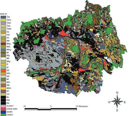
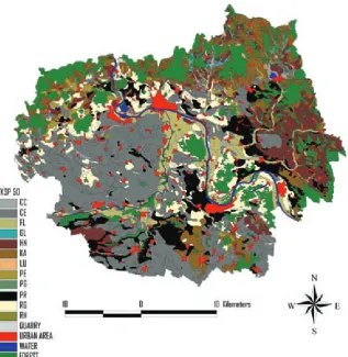
In the period of the General survey of agricul-tural soils (hereafter KPZP) in the 1960s, when the genetic-agronomic soil classification (hereafter GAK KPZP) was carried out, Rendzina soil type (RA) was the second most widespread soil type (after Chernozems) in the district of Litoměřice and was found on 22.63% of the district agricul-tural land (Němeček et al. 1965) (Figure 1). In the TKSP CR (the latest classification system), Rendzina is partially included in its most similar soil type, the newly established Pararendzina (PR) (highlighted in Figure 2), occurring on about 12% of the district agricultural land, partially in e.g. Regozem soil type, too.
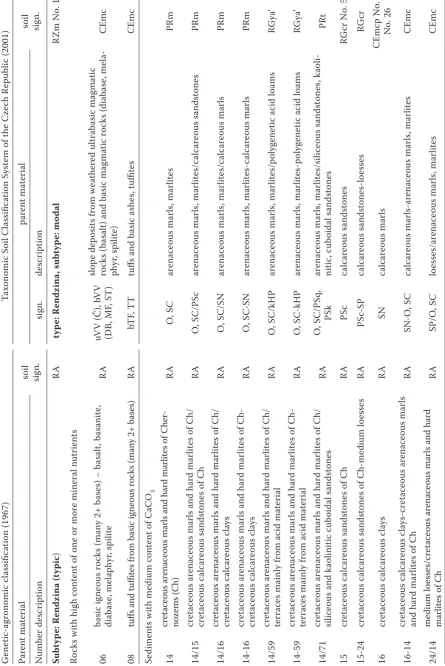
[image:2.595.97.513.359.734.2]In the genetic-agronomic classification of the General survey of agricultural soils (see Němeček et al. 1967), the soil type Rendzina covers the following main diagnostic horizons and features: light-coloured humus horizon, sorptive saturated to humus containing carbonates (h, hca, Orh, Orhca); sometimes dark humus horizon, sorptive saturated to containing carbonates (H, Hca, OrH, OrHca); under humus horizon carbonate substrate (Pca) or first horizon of weathering (V) with the thick-ness of up to 0.5 m, with fragments of carbonate rock; deeper carbonate rock (M) is always found. In the order of soils, Rendzinas are placed after brown and initial soils. The system distinguishes a group of subtypes of mountain locations and a group of subtypes of lower locations: the mountain subtypes are characterised by a more noticeable accumulation of humus and its deeper penetration in the profile. The genetic-agronomic classification distinguishes the following subtypes of Rendzinas:
(typic): found on a variety of substrates. It covers shallow gravelly soils, desiccative, with one-sided chemism (limestone, dolomites), as well as deeper profiles with a more balanced chemism on slightly consolidated silicate horizons with the admixture of carbonates and on marls; brown – h: found on marls, arenaceous marls, shallow to medium-deep residual products of limestone leaching and up to the depth of maximum 0.5 m decalcified carbonate substrates with a higher level of sorptive satura-tion; anthropogenic – an: created by draining or terracing of vineyards. The profile of the former is significantly modified by mechanical interven-tions and is enriched with organic substances (up to the depth of 0.4–0.5 m); the terrace in the latter is often a place of mineral and organic materials accumulation. Autohydromorphic subtypes and development stages are created in the conditions of local waterlogging, especially on heavier substrates, in RA units; flood-plain – l: increased moisture is accompanied by the accumulation of dark humus substances in a more powerful humus horizon; stagnic – g: gleying at decreased permeability of the profile above 1 m; gleyic – G: the influence of ground water or decreased permeability below 1 m.
The varieties of Rendzina are: dark – t: formed under locally favourable conditions for a more significant accumulation of humus – on limestone, marls, sometimes on other substrates; slightly stagnic – (g): slight gleying at decreased permeability of the profile above 1 m; slightly gleyic – (G): only local influence of ground water or decreased permeability below 1 m. The subtypes, varieties, and the forms of erosion are listed in Table 4, in the Results and Discussion section.
Rendzinas are classified as soils developing on limestones and dolomites, carbonate weathering ultra-basic rocks, consolidated sedimentary rocks with the admixture of carbonates (sandstones, shales), slightly consolidated sedimentary rocks, carbonate slope deposits, slightly consolidated carbonate clayey shales and neogenic sediments and on marls.
[image:3.595.65.383.84.410.2]profile (solid rock is found in the depth of up to 0.3 m). It allows only several types of horizons of organic matter accumulation in a limited propor-tion of fine earth – melanic horizon (Am), umbric horizon (Au), common is a sequence of litter (O) and humic forest horizon (Ah) and traces of cambic horizon (Bv) or micropodzolization.
The soil type Rendzina (RZ) forms from skeletal disintegrated carbonate rocks and is character-ised by stratigraphy of the soil profile O – Ah, Am, or Ap (topsoil horizon) – Crk (disintegrated solid rock with the content of carbonates higher than 5%) – Rk (solid rock with the content of carbonates higher than 5%). Especially detrital and surface-decalcified Rendzinas are accompa-nied by the formation of dark Am-horizons. The formation of Bv-horizons indicates the transitions to Cambisols and Luvisols. The TKSP CR (and already Hraško et al. 1991) distinguish the fol-lowing subtypes of Rendzinas: modal – m: with carbonates in the whole profile; melanic – n: more than 0.25 m thick, dark Am-horizon; cambic – k: up to 0.3 m presence of brown to yellow-brown Bv-horizon under Ah horizon; rubiphic – j: up to 0.3 m presence of rubiphic horizon Br; leached – v: carbonates leached out from fine earth of horizon of organic substances accumulation (at least in its upper part); lithic – t: compact rock in the depth of 0.1–0.3 m; talic – s: talus more than 0.5 m thick, with skeleton content over 80%. The varieties of Rendzinas are: shallow-melanic – n’: Am horizon thinner than 0.25 m, and mesobasic – a’: saturation of sorptive complex after Kappen is in Bv horizon of forest soils lower than 50% and saturation of sorptive complex after Mehlich is in Bv horizon of agricultural soils lower than 60%.
The subtypes, varieties, and forms of erosion are recorded in Table 4, in the Results and Dis-cussion section.
Like Rendzinas, Pararendzinas also belong to the referential class of Leptosols. Pararendzinas (PR) are soils from weathered and basal as well as shallow main formations of carbonate-silicate consolidated rocks, with skeleton content and with O – Ah (Am) or Ap – Crk – Rk stratigraphy. Gradual leaching and perhaps insufficiently thick layer of the soil formation form conditions for the transition to Kambizem. They occur locally in various climatic conditions, mainly in the areas of cretaceous and flysch consolidated sediments.
Regozems belong to the referential class of Re-gosols, which are soils formed from
non-con-solidated sediments, especially from sands and gravelled sands (they are sometimes classified as Arenosols), but also from other substrates. They lack a distinct cambic horizon. They have only common horizons of organic matter accumulation (O – Ah, Ap). The soil type Regozem (RG) repre-sents soils with O – Ah – C or Ap – C stratigraphy, and developed from friable sediments (mainly sands) in flat parts of a relief, where the substrate is poor in minerals (silicic sands etc.) or the short length of pedogenesis prevents a more distinct development of the profile. They are also found, however, on medium and heavy textured substrates, especially in the locations where the soil develop-ment is disrupted by water erosion.
The main reason for the complete disappearance of Rendzina from the district of Litoměřice after the reclassification is the fact that in the taxonomic system Rendzina is bound to limestone as the par-ent material, which results in the disappearance of those soil profiles of Rendzina, whose properties and characteristics would otherwise fall under the type also in the TKSP CR.
Hence it is necessary to discuss the basis of this limitation of Rendzina and to consider its neces-sity, as in the Czech soil classification, Rendzina is a traditional, though not very widespread, soil type – FAO soil unit Rendzic Leptosols occupies 0.23% of the surface of the Czech Republic (Kozák et al. 2000).
Table 1. Soil types and subtypes overview according to the soil map at the scale 1:50 000 for Litoměřice district
TKSP CR WRB
No. of polyg. (ha) Area (%)
Sign. sign. nomenclature
CCc’ caPH calcaric Phaeozem 15 367.99 0.46
CCm glPH gleyic Phaeozem 15 399.04 0.50
Phaeozems in total 30 767.03 0.96
CEc ccoCH orthicalcic Chernozem 198 17 327.92 21.82
CEl lvCH luvic Chernozem 17 706.47 0.89
CEm ccCH calcic Chernozem 153 8120.71 10.23
CEr arCH arenic Chernozem 42 2030.41 2.56
CEx glCH gleyic Chernozem 9 200.45 0.25
CExc’ glccoCH gleyic orthicalcic Chernozem 23 837.55 1.05
Chernozems in total 442 29 223.51 36.80
Phaeozems and Chernozems in total 472 29 990.54 37.76
FLc caFL calcaric Fluvisol 32 1366.52 1.72
FLm haFL haplic Fluvisol 84 4531.44 5.71
FLq glFL gleyic Fluvisol 10 393.09 0.50
FLqc glcaFL gleyic calcaric Fluvisol 19 815.22 1.03
Fluvisols in total 145 7106.27 8.96
GLm haGL haplic Gleysol, Gleysols 20 474.20 0.60
HNg stLV stagnic Luvisol 19 343.94 0.43
HNl abLV albic Luvisol 26 1085.91 1.37
HNlg abstLV albic stagnic Luvisol 1 21.40 0.03
HNm haLV haplic Luvisol 133 7128.07 8.98
Luvisols in total 179 8579.32 10.81
LUm haAB haplic Albeluvisol, Albeluvisols 9 112.91 0.14
Luvisols and Albeluvisols in total 188 8692.23 10.95
KAg stCM stagnic Cambisol 37 672.74 0.85
KAl lvCM luvic Cambisol 98 2547.08 3.21
KAlg stlvCM stagnic luvic Cambisol 12 183.85 0.23
KAm euCM eutric Cambisol 256 7741.92 9.75
Luvisols in total 403 11 145.59 14.04
PEm caCM calcaric Cambisol 49 1788.63 2.25
Cambisols in total 452 12 934,22 16.29
PGm haSG haplic Stagnosol Stagnosols 26 653.67 0.82
PRk cmcaLP cambic calcaric Leptosol 42 1747.16 2.20
PRkr cmarLP cambic arenic Leptosol 10 391.65 0.49
PRm caLP calcaric Leptosol 196 6102.57 7.69
PRn cahuLP calcaric humic Leptosol 16 997.07 1.26
PRr arLP arenic Leptosol 22 419.92 0.53
286 9658.37 12.17
RNm haLP haplic Leptosol 22 133.27 0.17
Leptosols in total 308 9791.64 12.34
RGp ceRG clayic Regosol 140 5585.96 7.03
RGr haAR haplic Arenosol 4 189.04 0.24
RGy skRG skeletic Regosol 85 3989.93 5.02
Regosols and Arenosols in total 229 9764.93 12.29
The Czech version of the international project SOTER methodology (CZESOTER 1:250 000) defines the dominant SOTER units, which places Rendzinas and Pararendzinas into a common cat-egory (marked as v) and allows also other parent materials than limestone and dolomite. It corre-sponds to WRB recommendations, which in no way prescribes to combine Rendzina only with limestone as the parent material: “A basic principle in soil mapping is that the soil surveyor designs the legend of the map so as to best suit the purpose of the survey. If the WRB is designed to support small-scale mapping of the global soil landscapes, it would be advantageous to have a structure that lends itself to support such overview maps. Hence, the discussion on the qualifier listings should not be held in isolation of the overview maps of the soils of the world or the continents in the WRB. Therefore, it is suggested that the WRB qualifi-ers be linked to small-scale soil maps as follows: prefix qualifiers for mapping between 1/5*106 and
1/106 scale; suffix qualifiers for mapping between
1/106 and 1/250*103 scale” (IUSS Working Group
WRB 2006: 7 and e.g. 54, 60, 84–85, 88). The more so in maps with the middle and detailed scales, which are left to national classifications: “For larger mapping scales, it is suggested that, in ad-dition, national or local soil classification systems be used. They are designed to accommodate local soil variability, which can never be accounted for in a world reference base” (IUSS Working Group WRB 2006). Rendzina should not be limited only to limestone.
A digital database of the primary and selected pits in the Litoměřice district and laboratory analyses of the pits from the 2006 soil survey have been used to examine the properties of the soils classified in the GAK KPZP as Rendzinas, and the properties of the soil types and subtypes into which Rendzinas are reclassified in the valid TKSP CR system.
It is necessary to solve the numerous problems which have appeared in the soil reclassification into the TKSP CR because there is no doubt about the importance of the archive KPZP data, about the possibilities of their updating and utilisation in digital mapping; and especially in digital map-ping is it necessary to reach a high conversion accuracy between the previous and the valid soil classification systems.
As the pilot district of Litoměřice was the first one to be mapped by means of SOTER method-ology on the middle scale, the SOTER soil map
highlights the dominant SOTER units containing the given soil type (Figure 5).
The above discussed issue of classification and reclassification of Rendzina is summarised at the end of the article in the form of an extract from the draft of the soils and parent materials con-vertor.
ReSultS And dISCuSSIon
As follows from Table 1, after the reclassifica-tion of Rendzinas from the GAK KPZP into the TKSP CR, the soil type has been not recognised in the Litoměřice district. The following map of TKSP CR-reclassified soils (Figure 2) highlights the soil type most resembling Rendzina found in the district – Pararendzina, which was not defined in the former genetic-agronomic soil classifica-tion at all.
When converting the Litoměřice district pits from the GAK KPZP into the TKSP CR, the fol-lowing occurred:
– Trouble-free conversions, in which the soil pits classified according to the valid system were as exact as the former classification or more exact;
– Conversions which, in order to be re-classifi-able, suppressed some of the properties and characteristics of a profile and emphasised oth-ers, although in the former classification they were equal;
– Profiles whose reclassification was impossible because TKSP CR does not allow some subtypes of Rendzina soil type to possess a certain prop-erty or characteristics.
Examples of a relatively trouble-free conversion as to the existence of a comparable subtype in the valid system are: Rendzina (typic) RA (WRB: rendzic Leptosol – rzLP) converted into Rendzina modal, Rendzina dark RAt (WRB: melani-rendzic Leptosol – merzLP) presently as Rendzina melanic, Rendzina brown RAh (WRB: rhodi-rendzic Lep-tosol – rorzLP) as Rendzina cambic or flood-plain Rendzina (WRB: melani-dystri-rendzic Leptosol – medyrzLP) RAl as Rendzina melanic and leached (examples No. 1–4 in Table 4).
Table 2. Results of laboratory analysis concerning a soil pit from the soil survey of Litoměřice district in 2006
Pit No. 3 horizon
Ad Ak1 Ak2 ACk C
Soil pr
op
er
tie
s and c
harac
ter
istic
s
Clay < 0.001 mm (%) 36.1 37.5 39.8 36.1 31.6
Clay < 0.002 mm (%) 46.9 48.7 51.2 47.8 44.2
Part. size I < 0.01 mm (%) 70.6 71.2 75.8 73.0 70.3
< 0.02 mm (%) 80.0 80.4 84.3 83.1 79.0
< 0.05 mm (%) 91.9 92.6 94.6 94.2 91.8
Part. size II 0.01–0.05 mm (%) 21.3 21.5 18.9 21.1 21.5
Part. size III 0.05–0.25 mm (%) 6.4 6.3 4.7 5.4 7.9
Part. size IV 0.25–2 mm (%) 1.7 1.0 0.7 0.5 0.4
pH active (–) 7.74 7.78 7.83 8.02 8.12
pH potential exchangeable (–) 7.30 7.35 7.42 7.48 7.67
Carbonates (%) 32.0 32.0 33.0 42.0 52.0
Cox (%) 1.66 1.48 1.26 1.06 0.50
θmom (% mass) 14.33 – – – –
θmom (% vol.) 23.37 – – – –
θMKK (% vol.) 25.72 – – – –
ρz (g/cm3) 2.64 – – – –
ρd red (g/cm3) 1.63 – – – –
P (% vol.) 38.26 – – – –
Vz (% vol.) 14.89 – – – –
KMKKVZ(% vol.) 12.54 – – – –
θns (% vol.) 37.97 – – – –
θBV (% vol.) 5.9 – –
Pot
en
tial (
cmol/kg)
CEC 26.79 26.55 26.83 23.41 19.12
S 34.30 34.05 34.61 31.83 27.52
K 0.90 0.70 0.60 0.56 0.52
Na 0.48 0.47 0.50 0.49 0.49
Mg 0.94 1.07 1.06 1.01 0.93
Ca 31.89 31.69 32.31 29.67 25.47
Al 0.09 0.12 0.14 0.10 0.11
Effic
ien
t (
cmol/kg)
ECEC 29.19 28.87 32.07 28.86 20.56
S 33.52 34.00 36.55 31.55 24.87
K 0.87 0.76 0.69 0.62 0.58
Na 0.58 0.60 0.62 0.62 0.61
Mg 1.06 1.15 1.15 1.16 1.06
Ca 30.98 31.40 34.03 29.09 22.53
Al 0.03 0.09 0.06 0.06 0.09
Potential – extract of 0.01M BaCl2 buffered by TEA to pH 8.1; Efficient – extract of not buffered 0.01M BaCl2
assignment of particular parent materials occur-ring in the area of Litoměřice district. Rendzina (typic) RA: on calcareous sandstones it belongs to Regozem arenic RGr; on calcareous clays and on loess covering loamy sands and gravelled sands it is included in Chernozem modal CEm; on clays it
is covered by Pelozem modal PEm; on mixed slope deposits it is included in Regozem pelic RGp.
pelic RGp (the decisive criterion was the need to emphasise the parent material; humus in topsoil horizon was not considered). Other conversions can reclassify Rendzina brown RAh: on arenaceous marls and hard calcareous marls it is classified as Pararendzina cambic PRk, on calcareous sand-stones as parent material (Regozem arenic, which would be preferable for calcareous sandstones in terms of the soil texture, does not allow cambic horizon) it is classified as Regozem psefitic RGy, as is the case with non-loamy sands and gravelled sands on arenaceous marls and hard calcareous marls; on calcareous marls it is classified as Pelozem modal PEm (pelic horizon is a harder-soil-texture analogue of cambic horizon), just like on mixed slope deposits (ex. No. 5–15 in Table 4).
The solution to the problems mentioned below in conversions of RAt 9, Rendzina dark on mixed slope deposit, RAh 15, Rendzina brown on calcareous marl, RAh 19, Rendzina brown on calcareous sandstone and RA 23, Rendzina (typic) on arenaceous marl, has been already validated by laboratory analyses of soil samples in the Central laboratories of the Research Institute for Soil and Water Conservation in Prague and can be considered as acceptable for the incorporation into the valid system:
– RAt 9 → RGp, …, Regozem pelic on mixed slope deposit – it is recommended to add a symbol for mixed slope deposit into the valid system; – RAh 15 → RGp, SN, Regozem pelic on calcareous
clay – the characteristics of Regozem pelic do not allow the existence of Bv-horizon – it is recom-mended to incorporate it into the system;
– RA 19 → PRr, PSc, Pararendzina arenic on cal-careous sandstone – its classification as Regozem arenic can be unambiguously ruled out;
– RAh 19 → PRkr, PSc, Pararendzina cambic and arenic on calcareous sandstone – its classifi-cation as Regozem cambic and arenic can be unambiguously ruled out;
– RA 23 → PRm, O, Pararendzina modal on arena-ceous marl – it should be emphasised that it is possible to determinate a modal subtype of Pararendzina on arenaceous marl only after the condition of appropriate particle size distribution is met – pH (sandy loam), H (loam), rH (silty loam), R (silt);
– RA 23 → PRr, O, Pararendzina arenic on arena-ceous marl – it should be emphasised that it is possible to determine an arenic subtype of Pararendzina on arenaceous marl only after the condition of appropriate particle size distribu-tion is met – P (sand), hP (loamy sand). Some former Rendzinas have thus been trans-ferred into Regozem and Pararendzina. In this respect, it is necessary to consider the parameters of the Regozem type (eventually Pararendzina) – to what degree is this soil type ready to accommodate part of the profiles of former Rendzinas:
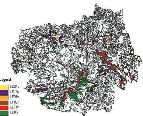
[image:8.595.70.531.113.293.2]– If the valid classification in practice requires the classification of part of former Rendzinas and sod soils as Regozems, a carbonated vari-ety should be delimited in this soil type, as the requirement of more than 3% of carbonates throughout the profile (Němeček et al. 2001) for a carbonated subtype is too strict. Moreover, Table 3. The dominant SOTER units with Rendzina and Pararendzina according to soil map SOTER at the scale 1:50 000 for Litoměřice district
Dominant SOTER units Signature (in PUGIS
CULS) Area (ha)
Rendzina, Pararendzina – v
On sedimentary rocks, medium wastes – 18
LD18v LF18v LL18v
1378.12 4074.12 3182.46
in total 8634.70
On bench gravel sands, sands, earthenware or to shallow loess overlaid terraces – 01
LD01v LF01v LL01v
333.07 455.54 22.96
in total 811.16
Area (ha) in total i.e. 11.82% a.l. of the district 9 445.86
Ta
ble 4. The sam
ple f
rom t
he wor
k version of t
he c
on
ver
tor of s
oil
s and p
ar en t ma ter ial s c onc er ning t o Rend zina s G ene tic -ag ronomic c la ssific ation (1967) Ta xonomic S oil C la ssific ation S yst
em of t
he Cze ch Re public (2001) Par en t ma ter ial
soil sign.
par
en
t ma
ter
ial
soil sign.
N umb er de sc ription sig n. de sc ription Su bt yp e: R end zi na (t ypic ) RA ty pe: R end zi na , su bt yp e: mo da l RZ
m No. 1
Ro ck s w ith hig h c on ten
t of one or mor
e mineral n
utr ien ts 06 ba si c ig ne ou s r oc ks (m any 2 + ba se s) – b as al t, ba sa ni te , di ab as e, me la ph yr , spilit e RA uV V (Č ), b V V (DB, MF , S T ) slop e de po sit s f rom we at her ed ultra ba sic mag ma tic ro ck s ( ba
salt) and b
asic mag ma tic r oc ks ( di ab as e, me la -ph yr , spilit e) C Emc 08 tuff
s and t
uffit es f rom b asic ig ne ou s r oc ks (man
y 2+ b
as es) RA bTF , T T tuff
s and b
asic a she s, t uffit es C Emc Se dimen ts w ith me dium c on ten
t of C
aC O3 14 cr et ac eou s ar enac eou s mar
ls and har
d mar
lit
es of C
her -no zems (C h) RA O , S C ar enac eou s mar ls , mar lit es PR m 14/15 cr et ac eou s ar enac eou s mar
ls and har
d mar
lit
es of C
h/ cr et ac eou s c alc ar eou s sand st one
s of C
h RA O , S C/P Sc ar enac eou s mar ls , mar lit es/c alc ar eou s sand st one s PR m 14/16 cr et ac eou s ar enac eou s mar
ls and har
d mar
lit
es of C
h/ cr et ac eou s c alc ar eou s c la ys RA O , S C/S N ar enac eou s mar ls , mar lit es/c alc ar eou s mar ls PR m 14-16 cr et ac eou s ar enac eou s mar
ls and har
d mar
lit
es of C
h-cr et ac eou s c alc ar eou s c la ys RA O , S C -S N ar enac eou s mar ls , mar lit es -c alc ar eou s mar ls PR m 14/59 cr et ac eou s ar enac eou s mar
ls and har
d mar
lit
es of C
h/
ter
rac
es mainly f
rom ac id ma ter ial RA O , S C/kH P ar enac eou s mar ls , mar lit es/p oly gene tic ac id lo ams RG ya’ 14-59 cr et ac eou s ar enac eou s mar
ls and har
d mar
lit
es of C
h-ter
rac
es mainly f
rom ac id ma ter ial RA O , S C -kH P ar enac eou s mar ls , mar lit es -p oly gene tic ac id lo ams RG ya’ 14/71 cr et ac eou s ar enac eou s mar
ls and har
d mar
lit
es of C
h/
silic
eou
s and k
aolinitic c ub oid al sand st one s RA O , S C /P Sq , PSk ar enac eou s mar ls , mar lit es/silic eou s sand st one s, k aoli -nitic , c ub oid al sand st one s PRt 15 cr et ac eou s c alc ar eou s sand st one
s of C
h RA PS c calc ar eou s sand st one s RG
cr No. 5
15-24 cr et ac eou s c alc ar eou s sand st one
s of C
h-me dium lo ess es RA PS c-S P calc ar eou s sand st one s-lo ess es RG cr 16 cr et ac eou s c alc ar eou s c la ys RA SN calc ar eou s mar ls C Emc
p No. 6
No. 26 16-14 cr et ac eou s c alc ar eou s c la ys -c re tac eou s ar enac eou s mar ls and har d mar lit
es of C
h RA SN -O , S C calc ar eou s mar ls -ar enac eou s mar ls , mar lit es C Emc 24/14 me dium lo ess es/c re tac eou s ar enac eou s mar
ls and har
d
mar
lit
es of C
[image:9.595.85.531.92.759.2]G ene tic -ag ronomic c la ssific ation (1967) Ta xonomic S oil C la ssific ation S yst
em of t
he Cze ch Re public (2001) Par en t ma ter ial
soil sign.
par
en
t ma
ter
ial
soil sign.
N umb er de sc ription sig n. de sc ription 25/59 whit e lo ess es/t er rac
es mainly f
rom ac id ma ter ial RA SP/kH P lo ess es/p oly gene tic ac id lo ams C
Em No. 7
25-59 whit e lo ess es -t er rac
es mainly f
rom ac id ma ter ial RA SP -kH P lo ess es -p oly gene tic ac id lo ams C Em Not c alc ar eou
s or we
ak ly c alc ar eou s Q ua ter nar y de po sit s 59 ter rac
es mainly f
rom ac id ma ter ial RA kH P poly gene tic ac id lo ams RG ya’ 59/14 ter rac
es mainly f
rom ac id ma ter ial/c re tac eou s ar ena -ce ou s mar
ls and har
d mar
lit
es of C
h RA kH P/O , S C poly gene tic ac id lo ams/ar enac eou s mar ls , mar lit es RG ya’ 59-14 ter rac
es mainly f
rom ac id ma ter ial-c re tac eou s ar ena -ce ou s mar
ls and har
d mar
lit
es of C
h RA kH P-O , S C poly gene tic ac id lo ams -ar enac eou s mar ls , mar lit es RG ya’ 59-16 ter rac
es mainly f
rom ac id ma ter ial-c re tac eou s calc ar eou s c la ys RA kH P-S N poly gene tic ac id lo ams -c alc ar eou s mar ls RG ya’ Slop e de po sit s 63a slo pe d ep os its , h ea vy lo am s t o cl ay ey sa nd s w ith smaller s ke le ton, f rom c arb ona te d ma ter ial RA SC slop e de po sit s f rom we at her ed mar lit es (L itoměř ic e di str ic
t – L
T
)
C
Ec
p No. 27
63a/14 slo pe d ep os its , h ea vy lo am s t o cl ay ey sa nd s w ith smaller s ke le ton, f rom c arb ona te d ma ter ial/c re tac eou s ar enac eou s mar
ls and har
d mar
lit
es of C
h RA SC/O , S C slop e de po sit s f rom we at her ed mar lit es (L T )/ar enac eou s mar ls , mar lit es RG cp 63a/16 slo pe d ep os its , h ea vy lo am s t o cl ay ey sa nd s w ith smaller s ke le ton, f rom c arb ona te d ma ter ial/c re tac eou s calc ar eou s c la ys RA SC/S N slop e de po sit s f rom we at her ed mar lit es (L T )/c alc ar eou s mar ls C Ec
p No. 28
63a/24 slo pe d ep os its , h ea vy lo am s t o cl ay ey sa nd s w ith sm al le r sk ele ton, f rom c arb ona te d ma ter ial/me dium lo ess es RA SC/S P slop e de po sit s f rom we at her ed mar lit es (L T )/lo ess es C Ec
p No. 29
63a/59 slo pe d ep os its , h ea vy lo am s t o cl ay ey sa nd s w ith smaller s ke le ton, f rom c arb ona te d ma ter ial/t er rac es mainly f rom ac id ma ter ial RA SC/kH P slop e de po sit s f rom we at her ed mar lit es (L T )/p oly gene tic ac id lo ams RGp
a’ No. 8
G ene tic -ag ronomic c la ssific ation (1967) Ta xonomic S oil C la ssific ation S yst
em of t
he Cze ch Re public (2001) Par en t ma ter ial
soil sign.
par
en
t ma
ter
ial
soil sign.
N umb er de sc ription sig n. de sc ription Su bt yp e: R end zi na (t ypic ), pha se: acc umul ate d RA ak ty pe: R end zi na , su bt yp e: mo da l, acc umul. pha se: acc umul ate d RZ m ak Se dimen ts w ith me dium c on ten
t of C
aC O3 14 cr et ac eou s ar enac eou s mar
ls and har
d mar
lit
es of C
h RA ak O , S C ar enac eou s mar ls , mar lit es PR m ak Slop e de po sit s 63a slo pe d ep os its , h ea vy lo am s t o cl ay ey sa nd s w ith sm al le r sk ele ton, f rom c arb ona te d ma ter ial RA ak SC slop e de po sit s f rom we at her ed mar lit es (L T ) C Ec p ak Su bt yp e: R end zi na (t ypic ), pha se: denude d RA sm ty pe: R end zi na , su bt yp e: mo da l, deg rad ation pha se: denude d RZ m sm Se dimen ts w ith me dium c on ten
t of C
aC O3 16 cr et ac eou s c alc ar eou s c la ys RA sm SN calc ar eou s mar ls C Emc p sm Slop e de po sit s 63a slo pe d ep os its , h ea vy lo am s t o cl ay ey sa nd s w ith sm al le r sk ele ton, f rom c arb ona te d ma ter ial RA sm SC slop e de po sit s f rom we at her ed mar lit es (L T ) C Ec p sm Var iet y: R . (t
.) and d
ar k RAt ty pe: R end zi na , su bt yp e: mel anic RZ
n No. 2
Se dimen ts w ith me dium c on ten
t of C
aC O3 14 cr et ac eou s ar enac eou s mar
ls and har
d mar
lit
es of C
h RAt O , S C ar enac eou s mar ls , mar lit es PR
n No. 9
14/16 cr et ac eou s ar enac eou s mar
ls and har
d mar lit es of C h/c re tac eou s c alc ar eou s c la ys RAt O , S C/S N ar enac eou s mar ls , mar lit es/c alc ar eou s mar ls PR n 14-27 cr et ac eou s ar enac eou s mar
ls and har
d mar lit es of C h-ter rac
es mainly f
rom c arb ona te d ma ter ial RAt O , S C -cH P ar enac eou s mar ls , mar lit es -p oly gene tic c arb ona te d lo ams PR n 16 cr et ac eou s c alc ar eou s c la ys RAt SN calc ar eou s mar ls C Emc
p No. 30
Not c
alc
ar
eou
s or we
ak ly c alc ar eou s Q ua ter nar y de po sit s 59-14 ter rac
es mainly f
rom ac id ma ter ial-c re tac eou s ar ena -ce ou s mar
ls and har
d mar
lit
es of C
h RAt kH P-O , S C poly gene tic ac id lo ams -ar enac eou s mar ls , mar lit es RG ya’ 59-16 ter rac
es mainly f
rom ac id ma ter ial-c re tac eou s calc ar eou s c la ys RAt kH P-S N poly gene tic ac id lo ams -c alc ar eou s mar ls RG ya’ 59-25 ter rac
es mainly f
[image:11.595.84.528.83.762.2]rom ac id ma ter ial-whit e lo ess es RAt kH P-S P poly gene tic ac id lo ams -lo ess es RG ya’ Ta
ble 4 t
G ene tic -ag ronomic c la ssific ation (1967) Ta xonomic S oil C la ssific ation S yst
em of t
he Cze ch Re public (2001) Par en t ma ter ial
soil sign.
par
en
t ma
ter
ial
soil sign.
N umb er de sc ription sig n. de sc ription Slop e de po sit s 63a slo pe d ep os its , h ea vy lo am s t o cl ay ey sa nd s w ith smaller s ke le ton, f rom c arb ona te d ma ter ial RAt SC slop e de po sit s f rom we at her ed mar lit es (L T ) C Ec
p No. 31
63a/14 slo pe d ep os its , h ea vy lo am s t o cl ay ey sa nd s w ith sm al le r sk ele ton, f rom c arb ona te d ma ter ial/c re tac eou s ar ena -ce ou s mar
ls and har
d mar
lit
es of C
h RAt SC/O , S C slop e de po sit s f rom we at her ed mar lit es (L T )/ ar enac eou s mar ls , mar lit es RG
cp No. 10
63a/16 slo pe d ep os its , h ea vy lo am s t o cl ay ey sa nd s w ith smaller s ke le ton, f rom c arb ona te d ma ter ial/c re ac eou s calc ar eou s c la ys RAt SC/S N slop e de po sit s f rom we at her ed mar lit es (L T )/ calc ar eou s mar ls C Ec
p No. 32
63a/25 slo pe d ep os its , h ea vy lo am s t o cl ay ey sa nd s w ith sm al le r sk ele ton, f rom c arb ona te d ma ter ial/whit e lo ess es RAt SC/S P slop e de po sit s f rom we at her ed mar lit es (L T )/ lo ess es C Ec
p No. 33
Var
iet
y: R
. (t
.) and s
lig htly st ag nic RA( g) thi s s oil e quiv alen
t not e
xi
st
s in t
he TKS
P C
R (2001) No. 16
Slop e de po sit s 63a slo pe d ep os its , h ea vy lo am s t o cl ay ey sa nd s w ith smaller s ke le ton, f rom c arb ona te d ma ter ial RA( g) SC slop e de po sit s f rom we at her ed mar lit es (L T ) C Ec pg ’ Var iet y: R . (t
.) and s
lig htly g le yic RA(G) thi s s oil e quiv alen
t not e
xi
st
s in t
he TKS
P C
R (2001) No. 17
Slop e de po sit s 63a slo pe d ep os its , h ea vy lo am s t o cl ay ey sa nd s w ith sm al le r sk ele ton, f rom c arb ona te d ma ter ial RA(G) SC slop e de po sit s f rom we at her ed mar lit es (L T ) RG qcp S ubt yp e: R . bro w n RAh ty pe: R end zi na , su bt yp e: c ambic RZ
k No. 3
Ro ck s w ith hig h c on ten
t of one or mor
e mineral n
utr ien ts 06 ba si c ig ne ou s r oc ks (m any 2 + ba se s) – b as al t, ba sa ni te , di ab as e, me la ph yr , spilit e RAh uV V (Č ), b V V (DB, MF , S T ) slop e de po sit s f rom we at her ed ultra ba sic mag ma tic ro ck s ( ba sa lt) a nd b as ic m ag m at ic ro ck s ( di ab as e, me la ph yr , spilit e) PEme’ Se dimen ts w ith me dium c on ten
t of C
aC O3 14 cr et ac eou s ar enac eou s mar
ls and har
d mar
lit
es of C
h RAh O , S C ar enac eou s mar ls , mar lit es PR
k No. 11
15 cr et ac eou s c alc ar eou s sand st one
s of C
h RAh PS c calc ar eou s sand st one s RG
cy No. 12
16 cr et ac eou s c alc ar eou s c la ys RAh SN calc ar eou s mar ls
PEme’ No. 14
G ene tic -ag ronomic c la ssific ation (1967) Ta xonomic S oil C la ssific ation S yst
em of t
he Cze ch Re public (2001) Par en t ma ter ial
soil sign.
par
en
t ma
ter
ial
soil sign.
N umb er de sc ription sig n. de sc ription Not c alc ar eou
s or we
ak ly c alc ar eou s Q ua ter nar y de po sit s 59-14 ter rac
es mainly f
rom ac id ma ter ial-c re tac eou s ar enac eou s mar
ls and har
d mar
lit
es of C
h RAh kH P-O , S C poly gene tic ac id lo ams -ar enac eou s mar ls , mar lit es RGy
a’ No. 13
Slop e de po sit s 63a slo pe d ep os its , h ea vy lo am s t o cl ay ey sa nd s w ith smaller s ke le ton, f rom c arb ona te d ma ter ial RAh SC slop e de po sit s f rom we at her ed mar lit es (L T ) PEme’ 63a/14 slo pe d ep os its , h ea vy lo am s t o cl ay ey sa nd s w ith smaller s ke le ton, f rom c arb ona te d ma ter ial/c re tac eou s ar enac eou s mar
ls and har
d mar
lit
es of C
h RAh SC/O , S C slop e de po sit s f rom we at her ed mar lit es (L T )/ ar enac eou s mar ls , mar lit es PEme’ 63a/59 slo pe d ep os its , h ea vy lo am s t o cl ay ey sa nd s w ith smaller s ke le ton, f rom c arb ona te d ma ter ial/t er rac es mainly f rom ac id ma ter ial RAh SC/kH P slop e de po sit s f rom we at her ed mar lit es (L T )/ poly gene tic ac id lo ams PEma
’ No. 15
63b slo pe d ep os its , h ea vy lo am s t o cl ay ey sa nd s w ith smaller s ke le ton, f rom b asic ma ter ial RAh bV V slop e de po sit s f rom we at her ed b asic mag ma tic ro ck s PEme’ 63b/16 slo pe d ep os its , h ea vy lo am s t o cl ay ey sa nd s w ith sm al le r sk ele ton, f rom b asic ma ter ial/c re tac eou s c alc ar eou s c la ys RAh bV V/S N slop e de po sit s f rom we at her ed b asic mag ma tic r oc ks/ calc ar eou s mar ls PEme’ Su bt yp e: R . bro w n, pha se: acc umul ate d RAh ak ty pe: R end zi na , su bt yp e: c ambic , acc umul. pha se: acc umul ate d RZ k ak Slop e de po sit s 63a slo pe d ep os its , h ea vy lo am s t o cl ay ey sa nd s w ith smaller s ke le ton, f rom c arb ona te d ma ter ial RAh ak SC slop e de po sit s f rom we at her ed mar lit es (L T ) PEme’ ak Var iet y: R - bro w
n and s
lig htly st ag nic RAh( g) thi s s oil e quiv alen
t not e
xi
st
s in t
he TKS
P C
R (2001) No. 22
63a slo pe d ep os its , h ea vy lo am s t o cl ay ey sa nd s w ith smaller s ke le ton, f rom c arb ona te d ma ter ial RAh( g) SC slop e de po sit s f rom we at her ed mar lit es (L T ) PEmg ’e’ Var iet y: R . bro w
n and s
lig htly g le yic RAh(G) thi s s oil e quiv alen
t not e
xi
st
s in t
he TKS
P C
R (2001) No. 23
[image:13.595.72.530.93.766.2]Slop e de po sit s 63a/16 slo pe d ep os its , h ea vy lo am s t o cl ay ey sa nd s w ith smaller s ke le ton, f rom c arb ona te d ma ter ial/c re tac eou s calc ar eou s c la ys RAh(G) SC/S N slop e de po sit s f rom we at her ed mar lit es (L T )/ calc ar eou s mar ls PEm-e’ Ta
ble 4 t
Su
bt
yp
e: R
. anthrop
og
enic
RA
an
ty
pe: Antrop
oz
em
AN
G
ene
tic
-ag
ronomic c
la
ssific
ation (1967)
Ta
xonomic S
oil C
la
ssific
ation S
yst
em of t
he Cze
ch Re
public (2001)
Par
en
t ma
ter
ial
soil sign.
par
en
t ma
ter
ial
soil sign.
N
umb
er
de
sc
ription
sig
n.
de
sc
ription
Su
bt
yp
e: flo
od – pl
ai
n R
.
RAl
ty
pe: R
end
zi
na Inter
fer
. of su
bt
yp
es
: mel
anic and le
ache
d
RZ
nv No. 4
Se
dimen
ts w
ith me
dium c
on
ten
t of C
aC
O3
14
cr
et
ac
eou
s ar
enac
eou
s mar
ls and har
d mar
lit
es of C
h
RAl
O
, S
C
ar
enac
eou
s mar
ls
, mar
lit
es
PR
nv
Su
bt
yp
e: R
. st
ag
nic
RAg
thi
s s
oil e
quiv
alen
t not e
xi
st
s in t
he TKS
P C
R (2001) No. 19
Se
dimen
ts w
ith me
dium c
on
ten
t of C
aC
O3
16
cr
et
ac
eou
s c
alc
ar
eou
s c
la
ys
RAg
SN
calc
ar
eou
s mar
ls
C
Exc
p
Su
bt
yp
e: R
. g
le
yi
c
RAG
thi
s s
oil e
quiv
alen
t not e
xi
st
s in t
he TKS
P C
R (2001) No. 21
I
nter
fer
.
: R
. (t
ypic
) and st
ag
nic
RAg
thi
s s
oil e
quiv
alen
t not e
xi
st
s in t
he TKS
P C
R (2001) No. 18
Inter
fer
.: R
. (t
ypic
) and g
le
yic
RAG
thi
s s
oil e
quiv
alen
t not e
xi
st
s in t
he TKS
P C
R (2001) No. 20
I
nter
fer
.
: R
. bro
w
n and st
ag
nic
RAhg
thi
s s
oil e
quiv
alen
t not e
xi
st
s in t
he TKS
P C
R (2001) No. 24
Slop
e de
po
sit
s
63c/16
slo
pe
d
ep
os
its
, h
ea
vy
lo
am
s t
o
cl
ay
ey
sa
nd
s w
ith
sm
al
le
r
sk
ele
ton, f
rom ac
id ma
ter
ial/c
re
tac
eou
s c
alc
ar
eou
s c
la
ys
RAhg
kV
V/S
N
slop
e de
po
sit
s f
rom we
at
her
ed ac
id mag
ma
tic r
oc
ks/c
al
-car
eou
s mar
ls
PEg
Inter
fer
.
: R
. bro
w
n and g
le
yic
RAhG
thi
s s
oil e
quiv
alen
t not e
xi
st
s in t
he TKS
P C
the other categories in the system do not always allow distinguishing the influence of the parent material with and without carbonates.
– For the reason mentioned above – the relocation of former Rendzinas and sod soils – it is possible to recommend also the introduction of a melanic subtype to Regozem. It is often impossible to make a compromise and place soils in Pararendzinas, considering the inappropriate parent material. – It is recommended do not bound medium parent
materials by the absence of carbonates (modal Regozem has to originate from medium parent materials without carbonates – Němeček et al. 2001), because then a modal subtype cannot be defined on loess, calcareous terraces etc., even if the other soil characteristics agree with this classification.
– If the sialitisation process is manifested in Re-gozems on light or hard parent materials, it is impossible to mark the corresponding subtypes ‘arenic’ and ‘pelic’ because brown metamorphic horizon is forbidden for these subtypes (Bv ab-sence – Němeček et al. 2001).
As stated by Sládková (2008), the conversions of the soil types and subtypes from the former one into the valid classification system, which does not consider the parent materials, show that there are Rendzina profiles in the Litomerice district with no equivalent subtype or variety in the TKSP CR. From Rendzinas they are in particular: Rendzina (typic) and slightly stagnic RA(g) (WRB: hypostagni-rendzic Leptosol – wstrzLP), and (typic) and slightly gleyic RA(G) (WRB: hypogleyi-rendzic Leptosol – wglrzLP), (typic) and stagnic as interference of subtypes and stagnic as a subtype – RAg (WRB: stagni-rendzic Leptosol – strzLP), (typic) and gleyic as
interfer-ence of subtypes and gleyic as a subtype – RAG (WRB: gleyi-rendzic Leptosol – glrzLP), followed by Rendzina brown and slightly stagnic RAh(g) (WRB: hypostagni-rhodi-rendzic Leptosol – wstrorzLP), Rendzina brown and slightly gleyic RAh(G) (WRB: hypogleyi-rhodi-rendzic Leptosol – wglrorzLP), Rendzina brown and stagnic RAhg (WRB: stagni-rhodi-rendzic Leptosol – strorzLP), and Rendzina brown and gleyic RAhG (WRB: gleyi-rhodi-rendzic Leptosol – glrorzLP) (example 16–25 in Table 4). The question is to what degree the features of mottling and gleying process should be representative. Every generalisation should be carefully accounted for and the reasons should be published.
[image:15.595.64.292.559.742.2]By far the largest practical problem of Rendzinas classification, however, seems to be the soil type boundedness to limestone as the parent material. Some Rendzinas in the GAK could be Rendzinas also in the more general TKSP CR, were it not for the restriction on parent material. Cf. Němeček et al. (1967) with Němeček et al. (2001), with the pit No. 3 in Figure 4, and example No. 26–33 in Table 4. It is possible to extend the parent materi-als admissible for Rendzina (ex. calcareous clay or carbonated slope deposit).
The pits of the 2006 soil survey also focused on the inaccuracies in the valid classification system, particularly on the changes in Rendzinas classifica-tion, on the refinement of Chernozems parameters, on a more accurate differentiation between the soil types Rendzina and Chernozem, and on the completion of the data for the new type Pelozem. For examples serve pits No. 3, 8, 9.
Pit No. 3: Location – cadastre Slatina, coordi-nates: X-764.869,76; Y-1.000.306,30
Map sheet: Libochovice 5-0
Classification – GAK KPZP: RA 16 Classification – TKSP CR: RZ, SN Soil profile: Ad-Ap1-Ap2-AC-C Soil profile
stratigraphy: GAK KPZP TKSP CR WRB
0–19 cm d Ad A
19–34 cm H1 Ak1 A
34–46 cm H2 Ak2 A
46–54 cm H/P ACk AC
> 54 cm P C C
Reasons for the selection:
[image:15.595.304.529.588.695.2]Figure 4. Profile appearance in the pit No. 3
Rendzina in TKSP also with other parent materi-als, not only with limestone.
– The research into local ultrabasic hard-textured parent materials.
– The same parent material as in pit No. 1 and the vicinity of pits No. 1 and 2 (similar conditions). Figure 3 represents a detail of the map around the pit No. 3; Figure 4 visualises the profile of the pit No. 3.
Pit No. 8
Reasons for the selection:
– The change in the classification of former Rend- zinas.
– The collection of the material for the soil type which is newly defined in the TKSP CR without any predecessors in older Czech soil classifica-tion systems.
– Carbonate content over 5% throughout the pro-file → it is proposed to define a new subtype Pelozem calcareous.
– The research into local ultrabasic hard-textured parent materials.
– A part of the district was mapped incorrectly in the General survey of agricultural soils (there are flood-plain soils according to the archive groundwork).
[image:16.595.64.366.511.755.2]Table 5. Soil conversions from the Czech soil classification systems to the WRB
Genetic-agronomic
classification (1967) System of the Czech Republic (2001)Taxonomic Soil Classification World Reference Base (1998, 2006)
Rendzina (typic)s Rendzina modal rendzic Leptosol – rzLP
Rendzina (typic)
and accumulated Rendzina modal and accumulated cumulirendzic Leptosol – crzLP Rendzina (typic)
and denunded Rendzina modal and denunded moderately eroded rendzic Leptosol – d3rzLP
Rendzina (typic) and dark Rendzina melanic melani-rendzic Leptosol – merzLP
Rendzina (typic) and slightly
stagnic – hypostagni-rendzic Leptosol – wstrzLP
Rendzina (typic) and slightly
gleyic – hypogleyi-rendzic Leptosol – wglrzLP
Rendzina brown Rendzina cambic rhodi-rendzic Leptosol – rorzLP
Rendzina brown
and accumulated Rendzina cambic and accumulated cumulirhodi-rendzic Leptosol – crorzLP Rendzina ‘brown and slightly
stagnic’ – hypostagni-rhodi-rendzic Leptosol – wstrorzLP
Rendzina brown and slightly
gleyic – hypogleyi-rhodi-rendzic Leptosol – wglrorzLP
Rendzina anthropogenic Antropozem technic Leptosol – teLP
flood – plain Rendzina Rendzina melanic and leached melani-dystri-rendzic Leptosol – medyrzLP
Rendzina stagnic – stagni-rendzic Leptosol – strzLP
Rendzina gleyic – gleyi-rendzic Leptosol – glrzLP
Rendzina (typic) and stagnic – stagni-rendzic Leptosol – strzLP
Rendzina (typic) and gleyic – gleyi-rendzic Leptosol – glrzLP
Rendzina brown and stagnic – stagni-rhodi-rendzic Leptosol – strorzLP
Rendzina brown and gleyic – gleyi-rhodi-rendzic Leptosol – glrorzLP
Pit No. 9
Reasons for the selection:
– The change in the classification of former Rendzi-nas.
– The research into local ultrabasic hard-textured parent materials.
– A part of the district was mapped incorrectly in the General survey of agricultural soils (there are flood-plain soils according to the archive groundwork).
Table 2 features the results of laboratory analyses concerning the pit No. 3.
The dominant SOTER units on the soil map SOTER including the discussed soil type are high-lighted (Figure 5) and described (Table 3).
What follows is an extract from the draft ver-sion of the convertor of soils and parent materials related to Rendzinas (Table 4). Table 5 includes the soil conversions from the Czech soil classification systems to the WRB.
The article is a contribution to the discussion on the need for further development of the valid soil classification system and increase in its preci-sion with regard to practical needs as well as the possibility of using the data from the original, more detailed system, which has been used for a long time and has proved suitable for the practice. At the same time, it is necessary to preserve the interconnection between the valid system, the international classification WRB system, and the international project SOTER.
References
Corresponding author:
Ing. Jitka Sládková, Ph.D., Výzkumný ústav meliorací a ochrany půdy, v.v.i., Žabovřeská 250, 156 27 Praha 5-Zbraslav, Česká republika
tel.: + 420 257 027 227, e-mail: [email protected] Blum W.E.H., Laker M.C. (2003): Soil classification
and soil research. In: Eswaran H., Rice T., Ahrens R., Stewart B.A. (eds): Soil Classification: A Global Desk Reference. Library of Congress Cataloging-in-Publication Data. CRC Press LLC, Florida, 43–49. Bouma J. (2003): Back to the old paradigms of soil
classi-fication. In: Eswaran H., Rice T., Ahrens R., Stewart B.A. (eds): Soil Classification: A Global Desk Reference. Library of Congress Cataloging-in-Publication Data. CRC Press LLC, Florida, 51–56.
Buol S.W. (2003): Philosophies of soil classifications: from is to does. In: Eswaran H., Rice T., Ahrens R., Stewart B.A. (eds): Soil Classification: A Global Desk Reference. Library of Congress Cataloging-in-Publication Data. CRC Press LLC, Florida, 3–10. Deckers J., Driessen P., Nachtergaele F.,
Spaarga-ren O., Bedring F. (2003): Further development of World Reference Base for soil resources. In: Eswaran H., Rice T., Ahrens R., Stewart B.A. (eds): Soil Classification: A Global Desk Reference. Library of Congress Cataloging-in-Publication Data. CRC Press LLC, Florida, 245–256.
Dudal R. (2003): How good is our soil classifications? In: Eswaran H., Rice T., Ahrens R., Stewart B.A. (eds): Soil Classification: A Global Desk Reference. Library of Congress Cataloging-in-Publication Data. CRC Press LLC, Florida, 11–18.
Hraško J., Linkeš V., Němeček J., Novák P., Šály R., Šurina B. (1991): Morphologic-genetic Soil Classificati-on System of the CSFR. VÚPÚ Bratislava. (in Slovak) ISSS-ISRIC-FAO (1998): World Reference Base for Soil
Resources. ISSS, ISRIC, FAO, Rome.
IUSS Working Group WRB (2006): World Reference Base for Soil Resources. Report No. 103, ISSS, ISRIC, FAO, Rome.
Kellogg CH.E. (1974): Soil genesis, classification, and cartography: 1924–1974. Geoderma, 12: 347–362.
Kozák J., Borůvka L., Němeček J. (2000): Soils in the Czech Republic: exploitation, evaluation and degradati-on. In: Proc. Conf. Soils in Central European Countries, New Independent States, Central Asian Countries and in Mongolia. Present Situation and Future Prospects. August 26–29, 2000, Prague, Research Institute of Crop Production and Czech University of Agriculture in Prague, Prague, 262–271.
Němeček J. et al. (1965): Systematic Soil Survey of the ČSSR – the Accompanying New for the District of Litoměřice. SPN Praha. (in Czech)
Němeček J., Damaška J., Hraško J., Bedrna Z., Zuska V., Tomášek M., Kalenda M. (1967): Survey of Ag-ricultural Soils of the ČSSR. Collected Methodology. Vol. 1, MZV, Praha, 134–139. (in Czech)
Němeček J., Kozák J. (2001): The Czech taxonomic soil classification system and the harmonization of soil maps. In: Micheli E., Nachtergaele F.O., Jones R.J.A., Montanarella L. (eds): Soil Classification 2001. Research Report No. 7, European Soil Bureau, Luxembourg, 47–53.
Němeček J., Macků J., Vokoun J., Vavříček D., Novák P. (2001): Taxonomic Soil Classification System of the Czech Republic. ČZU, Praha. (in Czech)
Sládková J. (2008): Precision of soil classification systems conversion as prerequisite for archive data elaboration in digital mapping. In: Sobocká J., Kulhavý J. (eds): Soil in Modern Information Society. Proc. 1st Conf. Czech Soil Science Society and Societas Pedologica Slovaca. August 20–23, 2007, Rožnov pod Radhoštěm, VÚPOP, Bratislava, 651–657.
Vokoun J. et al. (2003): Handbook for Survey of Forest Soils. Taxonomic soil classification system of the Czech Republic in Forest Practice. ÚHÚL, Brandýs n. L. (in Czech)