VOLUME 16 ISSUE 4 (2018), Page 55 – 67
EARLY TOWN PLANNING SYSTEM OF SMALL TOWNS IN PERAK
Mohd Jaki Mamat1 & Muhammad Firzan Abdul Aziz2
1&2School of Housing Building and Planning
UNIVERSITI SAINS MALAYSIA
Abstract
The township planning in Perak was affected post-signing of the Pangkor Treaty in 1874, as the state became the first state in Malaysian Peninsula intervened by the British. Introduction of grid system by the British has apparently affected the early layout of major cities such as Ipoh, Taiping, Kuala Lumpur, George Town and Singapore. This study attempts to investigate the theory of town planning during the British era after noticing a knowledge gap in regard to early town planning system of small towns in Perak. Based on purposive sampling using varying topographies as the criterion of site selection, 10 out of 20 small towns in Perak were selected for data collection. The small towns were Kuala Kurau, Klian Intan, Bagan Datoh, Lumut, Parit, Tanjung Rambutan, Pusing, Sungkai, Padang Rengas and Lenggong. Besides measured drawings, interviews were conducted with the locals and historical manuscripts of the research locale were also revisited. Based on comparative analysis, the study found that topographical factor was insignificant in influencing the early layout of small towns in Perak since linear system was used at different topographical background (riverside, coastal, hilly terrain and flatland areas). Moreover, location factor was found to be significant in terms of influencing the arrangement of early shophouse buildings into rows, which influenced the early layout of small towns in Perak.
INTRODUCTION
Perak was the first state in the Malaysian Peninsula intervened by the British after the signing of Pangkor Treaty in 1874. Ever since, the formation of several towns in Perak started to appear as a consequence of the state’s socioeconomic and physical development. Reportedly during the early physical development of Perak, formation of small towns (that emerged from the arrangement and concentration of shophouse buildings into rows) has brought upon health and safety issues (Home, 1997; Nasution & Lubis, 2005). Sensitising the scenario, application of grid system at the affected sites or exploration and development of nearby areas were advocated by the British as the town re-planning measures (Nasution & Lubis, 2005; Wan Mokhtar, 2016).
Historically, the English Town Planning Act 1932 and the British Planning Legislation 1932 were the two influential guidelines regulated by the British with regard to town planning in Malaysia (Home, 1997; Garnaut, 2004). Owing to that, the grid system was then introduced and implemented, which affected the planning of early Malaysian cities such as Ipoh, Taiping and Teluk Intan of Perak (Yuen, 2011; Wee, Yoon, & Guan, 2014) as well as the capital city, Kuala Lumpur (Garnaut, 2004). Despite the policy enforcement, the underlying factor which caused several small towns in Perak remain unaffected in terms of their physical layout was presumably due to their average economic expansion. Acknowledging so, this paper emphasises the needs of conducting an empirical investigation on the early small towns in Perak through their rows of shophouse buildings which is regarded as the main element of town formation (Symonds, 2005). Analysis of their layout pattern and topographical correlation are deemed imperative especially when shophouse buildings are ethos from the past. Evidently, they still bear the heritage value of old township formation despite facing serious threats arising from modern development pressure, urban dereliction and high deterioration rate (Bissel, 2005; Wee et al., 2014).
EARLY TOWN PLANNING
formation of early towns during the British years - in which their planning considerations did not emphasise on the significance of community factor (Yuen, 2011). Instead, the British was more concerned with safety and administration issues (Mizushima, 1997; Taylor, 2010) over business and trading activities (Garnaut, 2004; Mamat, 2016). Meanwhile in Perak, the British was more concerned with safety aspect for small towns located in distance with the state’s main cities (Tilaki, Abdullah, Bahauddin, & Marzbali, 2014; Mamat, 2014; Mamat, 2016).
Theoretically, the physical layout of townships or cities is dependent on various factors, mainly including the local economic activities (Larkham, & Lilley, 2012) involving business centres (Wan Ali et al., 2015), agricultural products (Syed Zainol, 1995), shipping ports (Lewandowski, 1975; Hassan, 2009; Harun & Jalil, 2012) and also land transportations such as railway and traffic networks (Ibrahim et al., 2014). Implying from that, these locations typically turned to be the focal points of their respective localities (Yuen, 2011). On the other facet, topographical condition was known to be influential towards a town’s form and layout (Lockard, 1974; Mohd, Ahmad, & Wan Abd Aziz, 2009; Shamsuddin, 2011).
In the case of Perak specifically, its town formation was also influenced by the state’s natural resources and its transportation network (Ortolano, 2011; Symonds, 2005). Most of the towns in Perak are associable with the state’s tin mining industry, as evidenced through its infrastructural developments such as shophouses, administration offices, labourer’s residence, roads and so on (Ahmad, 2013). The policy enforced in regard to town formation upon the British arrival in Malay Peninsula was in line with Town Planning Enactment 1923 (Garnaut, 2004) and Town Planning Act 1932 (Taylor, 2010) - to address the issues of safety as well as divide and rule policy (Home, 1997; Njoh, 2008). Despite the implementation of the two legislations by the British, involvements of their town planners and architects happened only after the localities reached the states of stability and safety (Hassan, 2009). In essence, town formations in Malay Peninsula occurred primarily due to the business activities and commercial relationships between the Chinese merchants and the local Malays (Ahmad, 2013; Wan Ali et al., 2015; Mamat, 2016). This interrelationship has indirectly influenced the physical layout of Perak townships, as seen in the rows of shophouses built on the land owned by the Malays for instance (Mizushima, 1997).
tune with Haverfield’s (1913) assertion that most towns or cities initially were formed either by a straight or curvy lines (depending on the sites’ topographical condition), which later merged with each other. Those lines typically were in parallel, or taking into accounts of the layout of the existing settlements (Lewandowski, 1975). This is in line with Taylor (2010) who posited that the evolvement of a township is commonly based on the offset of its settlements’ arrangement in the forms of centralised, linear and etc. In this manner, groups of shophouse that row along streets eventually led to the formation of a town (Garnaut, 2004).
Most of the architectural design and built of shophouse buildings found in Perak originated from the mainland of China (Shamsuddin, 2011). With main road as their frontage and back lane at their rear side, the rows of shophouse basically correspond to the linear town planning system (Wan Ali et al., 2015). This is in contrast with the British town planning concept in the use of grid system which emphasised segregation of land based on their functions such as administration, commercial, residential (Hassan, 2005; Shamsuddin, 2011), recreational (Bissell, 2005; Harun & Jalil, 2012)and logistical (Ibrahim et al., 2014) zones. Besides facilitating the conurbation process (Harun & Jalil, 2012), implementation of the grid system also supported the divide and rule policy applied by the British, especially for the purpose of social segregation based on race and status (Bissell, 2005; Hassan, 2009).
Based on the literature review, it is found that the early layout of towns or cities was influenced by their respective existing settlements. Apart from that, other influential factors include land topologies, economic activities and logistics. Only after the British arrival, town planning approach in Perak has shifted to the grid system following the land segregation and zoning purposes. This historical fact is thus imperative as point of reference to further understand the early small town planning system through data collection conducted at 10 selected small towns in Perak.
METHODOLOGY
Hence, acquisition of primary data through interviewing the locals was essential to complement the secondary data in validating the early row of shophouses. Interviewees were sampled based on their current position at the research locale (chief villager or head of the community), relationship with the buildings (owner and end-user), and knowledge or familiarity with the subject matter (historian or local figure). The entire shophouses from the 10 small towns identified were then further analysed to determine their sizes, number of units and locations. Subsequently, the information gathered was matched with plans based on PerakGIS (Geographic Information Systems) issued by the Federal Department of Town & Country Planning Peninsular Malaysia. Layouts of the small towns were then reproduced digitally using AutoCAD software to carefully examine and analyse the early town planning system. To narrow down the scope of the study, only linear and grid town planning systems were looked into as the indicator of early town formation. Other town planning systems such as clustered or scattered were left out from the current study considering that these systems contradict with the nature of shophouse characteristics (which physical arrangement is based on rows).
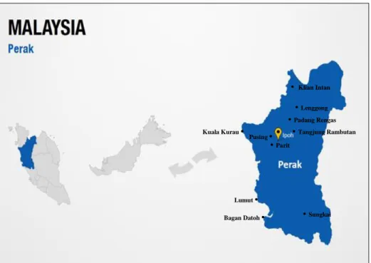
Figure 1: Location of selected small town in Perak, Malaysia
Source: Google Image
• Klian Intan
•Lenggong
•Padang Rengas Kuala Kurau •
Bagan Datoh • •Sungkai
•Parit
•Tangjung Rambutan Pusing •
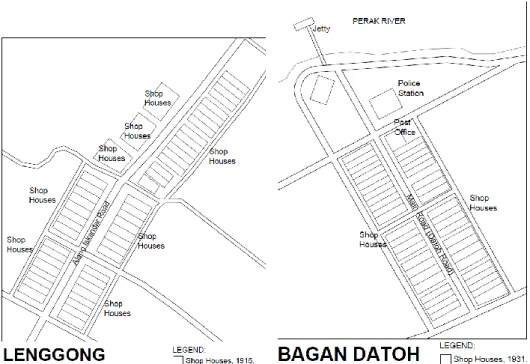
Figure 2 – Figure 11: Layout plan of the selected small towns in Perak
ANALYSIS AND FINDINGS
Based on scrutiny on the early layouts of 10 small towns in Perak as shown in Figure 2 to Figure 11, it was found that the grid system was merely applied to one of the small towns - Tanjung Rambutan. The underlying reason for this scenario can be associated with the British effort in developing a new township to replace the old Tanjung Rambutan, in the quest to cater its cleanliness issue apart from complementing its infrastructural needs of railway transportation that started operation in 1896. The old layout of Tanjung Rambutan however, is unknown, and irretrievable after the fire tragedy which occurred in 1897 that destroyed earlier records. The planning of a new Tanjung Rambutan township since 1893 by the British was based on the positioning of shophouse rows flanking the main roads, with residential buildings allocated at the rear side of shophouse buildings.
(collectively known as the Straits Settlements, governed by the British during 1874 until 1934), despite the segregation of commercial and administration (district office, residence of British officers, hospital etc.) zones at that time.
This study also found that topological factor was insignificant in influencing the town planning of the early layout of the small towns in Perak. This is rationalised by the use of linear system despite the existence of various topography conditions such as riverside, coastal, hilly terrain and flatland areas. Although the linear system is theoretically suitable for hilly terrain areas such as in Lenggong and Klian Intan following the difficulty to do the offset on rows of shophouses, it ironically was also used to flat land areas as seen in Pusing, Sungkai and Padang Rengas. Even more, the linear system was also used at flat land areas in close proximity to riverside and coastal areas such as in Kuala Kurau, Lumut, Parit and Bagan Datoh. This particular finding thus testified that the linear system was used for the early town planning system of small towns in Perak regardless of their topological factor.
In addition, this study also found that the early shophouse buildings were collectively built by the Malays (in Sungkai, Pusing and Padang Rengas), the Chinese (in Kuala Kurau, Lenggong, Parit, Bagan Datoh and partially in Pusing) and the British (in Tanjung Rambutan, Klian Intan and Lumut). In light of this, the British interventions in the local construction history were not limited to administrative, residential, public and military buildings, but also include commercial premises. This study also revealed that in terms of land ownership, the initiation stage of townships was built on the land owned by the Malays especially in Pusing, Padang Rengas and Lengong. Merely land of shophouses at Kuala Kurau was found to be owned by the Chinese. Imperatively, the British was involved in determining and dividing the lots for constructing shophouses at that time.
Table 1: Early town planning system of small towns in Perak
Town First
built
Builder
(owner) Land owner Topology Economy
Layout system Tanjung
Rambutan
1893 British British plots Flat land – riverside
Tin mining/ railway station
Grid – rows of shophouses on both side of the main road
Pusing 1890s Local
Malay and Maindailing /Chinese
Local Malay /Maindailing
Flat land Tin mining Linear – 2 row shophouses on one side of the main road
Sungkai 1900 Local
Malay & Chinese
Unknown Flat land Agriculture/ railway station
Linear – 2 rows
shophouses on both sides of the main road Padang
Rengas
1900s Local Malay
Local Malay Flat land Agriculture Linear – 4 row shophouses on both sides of the main road Kuala
Kurau
1900s Chinese Chinese Coastal area & riverside
Fishery & agriculture
Linear – 1 row shophouses on one side of the river
Lenggong 1915 Chinese Local Malay Hilly terrain Agriculture Linear – 2 row shophouses on one side of the main road Klian Intan 1909 British British plots Hilly terrain Tin mining Linear –
semi-detached shophouses on one side of the road
Lumut 1920s British British plots Coastal area Port Linear – 2 rows
shophouses on both sides of the main road Parit 1928 Chinese British plots Riverside Agriculture Linear – 2
rows
shophouses on both sides of the main road Bagan
Datoh
1931 Chinese British plots River and coastal area
CONCLUSION
To conclude, the linear system was used in the early town planning system of small towns in Perak. In consolidating the claim, there were no land lots found available for adding more premises (land expansion based on the grid planning system) at the sites under this study. This finding is supported by both primary (interviews conducted) and secondary (document review) data acquired pertinent to the 10 small towns in Perak. Despite the introduction of the grid system by the British for the planning of major cities in Perak, it was not applied in the planning of small towns. Instead, the linear system was adopted and implemented by the British following its practicality in the planning of small towns which are relatively smaller in size compared to cities. Despite so, the uses of grid system for land expansion are still found today in towns such as Pusing, Bagan Datoh, Lumut, Parit, Lenggong, Sungkai and Kuala Kurau. Nevertheless, its implementation is merely found on new sites located away from the immediate surroundings of the earliest rows of shophouse.
Apart from the British interventions in town and city planning, this study also acknowledges the equal role played by the local Malays and Chinese merchants. In particular, there was a technical relationship existed between the local Malays and Chinese merchants in terms of provision of lands and construction of premises, thus influencing the location and layout pattern of the early row of shophouses of the small towns in Perak. Conclusively, the layout of small towns in Perak was influenced mainly by commercial activities, through the building of shophouses by Chinese merchants on the lands owned by the local Malays. The small towns in Perak basically emerged as a result from the centralisation of the existing Malays’ settlements as well as the new settlements formed by the Chinese immigrants who ran the tin mining industry.
ACKNOWLEDGEMENT
The authors would like to acknowledge the Town and Country Planning of Perak (Federal Department) for funding the current studies under the project grant received in 2015 and 2016. Special credits also go to the lecturers and students of Ungku Omar Polytechnic, Perak Heritage Society (PHS), local councils and district offices, local communities, respective building owners and individuals who have directly and indirectly contributed in the process and conduct of this study.
REFERENCES
Abidin, N. Z., Shahminan, R. N. R., & Ibrahim, F. K. (2017). Architectural influences of
Istana Lama Seri Menanti, Negeri Sembilan. Planning Malaysia, 15(1),
151-162.
Ahmad, S., & Jones, D. (2013). Investigating the mining heritage significance for Kinta
District, the industrial heritage legacy of Malaysia. Procedia - Social and
Bissell, W. C. (2005). Engaging colonial nostalgia. Cultural Anthropology, 20(2), 215-248.
Federal Department of Town & Country Planning Peninsular Malaysia (2009). Perak
town profile report. Ipoh: Author.
Garnaut, C. (2004, July). Chronicles from the Far East: The garden city model of planning
in the Federated Malay States, 1920-1929. 11th Conference of the International
Planning History Society (IPHS). July 14-17, 2004, Barcelona, Spain.
Harun, N. Z., & Jalil, R. A. J. (2012). The morphological history of the Malaysian urban
form. International Proceedings of Economics Development and Research,
48(24), 111-116.
Hassan, A. S. (2009). The British colonial ‘divide and rule’ concept: Its influence to
transport access in inner city of Georgetown, Penang. Transportation, 36,
309-324.
Hassan, A. S. (2005). Rekabentuk bandar di Semenanjung Malaysia. Penang: Penerbit
Universiti Sains Malaysia.
Haverfield, F. (1913). Ancient town-planning. London: Oxford University Press.
Home, R. (1997). Of planting and planning: The making of British colonial cities (1st
edition). London: Chapman & Hall.
Ibrahim, M. H., Baharom, A. A., Ariffin, K., Jabar, B., Marzuki, M., & Kamaludin, K. (2014). Investigation of the landscape change in old Malaysian railways: Special
references to Port Weld-Taiping railway. The Social Sciences, 9(5), 357-361.
Larkham, P., & Lilley, K. (2012). Exhibiting the city: Planning ideas and public
involvement in wartime and early post-war Britain, Town Planning Review,
83(6), 647-668.
Lewandowski, S. J. (1975). Urban growth and municipal development in the colonial city
of Madras, 1860-1900. Journal of Asian Studies, 34(2), 341-360.
Lockard, C. A. (1974). The Southeast Asian town in historical perspective: A social history of Kuching, Malaysia, 1820-1970 (Doctoral dissertation). University of Wisconsin, USA.
Mamat, M. J. (2016). Lenggong: World Archaeology Heritage Town. Ipoh: Federal
Department of Town & Country Planning Peninsular Malaysia.
Mamat, M. J. (2014). Papan: The oldest mining town in Kinta. Ipoh: Federal Department
of Town & Country Planning Peninsular Malaysia.
Mizushima, T. (1997). A historical study on land transaction in a local town in Malaysia
Kuala Kangsar shop lots between 1885 and 1995. Regional Views, 10, 81-111.
Mohd, I., Ahmad, F., & Wan Abd Aziz, W. N. (2009). Exploiting town planning factors in land development: Case study of urban housing in Kuala Lumpur, Malaysia.
Journal of Facilities Management, 7(4), 307-318.
Nasution, K. S., & Lubis, A. R. (2005). Kinta Valley: Pioneering Malaysia’s modern
development. Ipoh: Perak Academy.
Njoh, A. J. (2008), Colonial philosophies, urban space and racial segregation in British
and French Colonial Africa. Journal of Black Studies, 38(4), 579-599.
Ortolano, G. (2011). Planning the urban future in 1960s Britain. The Historical Journal,
Samsudin, N. A., & Idid, S. Z. A. (2016). Influences of housing settings and designs in
fulfilling the Malay residents’ social cultures. Planning Malaysia, 4(Special
Issue), 109-120.
Shamsuddin, S. (2011). Townscape revisited: Unravelling the character of the townscape
in Malaysia. Skudai: Penerbit UTM Press.
Symonds, J. (2005). Dirty old town? Industrial archaeology and the urban historic
environment. Industrial Archaeology Review, XXVII(1), 57-65.
Taylor, N. (2010). Commentary: What is this thing called spatial planning? An analysis
of the British government’s view. Town Planning Review, 81(2), 193-208.
Tilaki, M. J. M., Abdullah, A., Bahauddin, A., & Marzbali, M. H. (2014). The necessity of increasing livability for George Town World Heritage Site: An analytical
review. Modern Applied Science,8(1), 123-133.
Wan Ali, W. N., Abdul Hadi, N. H., & Ishak, N. R. (2015, October). An overview on the
typology of shophouses’ façade at the heritage area in Ipoh City. Postgraduate
Conference on Global Green Issues (Go Green),UiTM (Perak). October 7-8, 2015, Perak, Malaysia.
Wan Mokhtar, W. N. H. (2016). Tanjung Rambutan; A serene town at the foot of Mount
Korbu. Ipoh: Federal Department of Town & Country Planning Peninsular Malaysia.
Wan Mokhtar, W. N. H. (2015). Bagan Datoh; The earliest coconut plantation town.
Ipoh: Federal Department of Town & Country Planning Peninsular Malaysia. Wee, L. H., Yoon, K. T., & Guan, G. G. (2014). Revitalisation of the old township of
Ipoh, Malaysia. Journal of Place Management and Development, 7(1), 57-73.
Yuen, B. (2011). Urban planning in Southeast Asia: Perspective from Singapore. Town
Planning Review, 82(2), 145-167.