IMPACTS OF STORMS AND SEA-LEVEL RISE ON COASTAL EVOLUTION BETWEEN TWO CAPES: ONSLOW BAY, NORTH CAROLINA
Winnie Yu
A thesis submitted to the faculty of the University of North Carolina at Chapel Hill in partial fulfillment of the requirements for the degree of Master of Science in the Department
of Marine Sciences
Chapel Hill 2012
Approved by:
ABSTRACT
WINNIE YU: Impacts of storms and sea-level rise on coastal evolution between two capes: Onslow Bay, North Carolina
(Under the direction of Antonio B. Rodriguez)
ACKNOWLEDGEMENTS
I would like to acknowledge my advisor, Dr. Antonio Rodriguez, for his support and thoughtful guidance throughout this study. His extensive knowledge on the subject and enthusiasm for it has been an inspiration to me. My gratitude is due to Dr. Harvey Seim and Dr. Brent McKee for providing their suggestions and valuable time in guiding me throughout the development of my project and the completion of this manuscript. I would also like to thank the members of the coastal geology lab: Robin Mattheus, Ethan Theuerkauf, Justin Ridge, Patricia Rodriguez, Erin Fegley, Dan Hood, Richard Browne and Noel Anderson for their help in the field and in the lab. Funding for this research was provided by the U.S. Department of Defense (DoD) Strategic Environmental Research and Development Program (SERDP). Special thanks to the Department of Marine Sciences and the Institute of Marine Sciences for providing the resources, facilities, and support for me to pursue my interest in my graduate work.
I wish to take this opportunity to thank my family for their unconditional support and encouragement that they have provided me. To the wonderful friends I met in North
TABLE OF CONTENTS
LIST OF TABLES………...vi
LIST OF FIGURES………vii
CHAPTER I 1. INTRODUCTION………...1
2. STUDY AREA………6
3. METHODS………10
3.1 Coring………10
3.2 Radiocarbon Dating………...11
3.3 Loss on ignition……….12
4. RESULTS AND INTERPRETATIONS………...12
4.1Depositional Environments and Lithologic Facies………12
4.2Stratigraphy………30
4.3Timing of washover fan emplacement………...45
5. DISCUSSION………46
5.1 Along-shore variability in rates of shoreline transgression along Onslow Beach and Onslow Bay……….46
5.2 Storm Impacts………53
LIST OF TABLES
Table
LIST OF FIGURES Figure
1. Study Area Map…..……….7
2. Shoreline Change Graph…………..………8
3. Beach facies………...13
4. Dune facies……….15
5. Marsh facies………...17
6. Ternary Plot of Grain Size by Facies……….19
7. F2wash Cross Section………20
8. Proximal Washover Fan Subfacies.………...21
9. Distal Washover Fan Subfacies……….23
10.Marginal Lagoon Subfacies………...………25
11.Central Lagoon Subfacies……...………...26
12.Facies B (Pre-Holocene Unit)………28
13.Grain Size Distribution of Beach Facies vs. Facies B…..………..………….…..29
14.F1 Cross Section………31
15.F1BB Cross Section………..……….32
16.F2 Cross Section………33
17.F2strike Cross Section……….………..34
18.F3 Cross Section………...………...………..35
19.Pier Cross Section………..36
20.F4 Cross Section………...……….37
22.F6 Cross Section………39
23.F6BB Cross Section………...………40
24.Barrier Island Fence Diagram………48
CHAPTER I 1. INTRODUCTION
Genesis of the cuspate shoreline morphology of the southeastern United States has been a topic of debate. The regional shoreline is dynamic and, during the post last glacial maximum transgression, it has coincided with the relatively straight current shelf margin at approximately 35 meters below modern sea-level. The set of four capes along North Carolina and South Carolina were likely produced by non-uniform rates of shoreline retreat along the coast during the late Pleistocene to Holocene sea-level rise. Although a single conclusive theory has yet to emerge, abundant research has explored the processes that control the size and time necessary for development of the capes and embayments, particularly the influence of underlying geology and shoreface hydrodynamics (Toumey, 1848; Abbe, 1985; Gulliver, 1896; Hoyt and Henry, 1967; Pierce and Colquhoun, 1970; Heron Jr. et al., 1984; Hoyt and Henry, 1971; Ashton et al., 2001).
This study is a core-based investigation of the evolution of a barrier island, Onslow Beach, centrally located between Cape Lookout and Cape Fear in Onslow Bay. The
fundamental objectives are to (1) identify environments and interpret the
For over a century, the mechanisms that control cape origin and development along the well-developed cuspate forelands of the North Carolina and South Carolina coast have been heavily researched. Each cape consists of two barrier islands or mainland beach ridges attached at approximately right angles. The capes are spaced approximately 100 km apart and separated by broad embayments. Early theories speculated that eddy currents shed from the Gulf Stream were the dominant forces shaping these prominent coastal features and that opposing waves and currents help maintain the cape structure. (Toumey, 1848; Abbe, 1895; Gulliver, 1896).
and geometry of coastal systems (Belknap and Kraft, 1985; Demarest and Leatherman, 1985).
Recently, the idea of waves and currents building capes has been resurrected to explain the origin and evolution of the large-scale rhythmic morphology of the southeast U.S. coast. While past researchers speculated that wave refraction concentrated energy on the headlands and caused erosion and reduction in the size of the capes, McNinch and Wells (1999) demonstrated that modern sediment transport due to alongshore currents is directed toward the cape tip and is actively supplying cape-associated subaqueous shoals with sand. Ashton et al. (2001) used a numerical model to show that high-angle waves can develop large-scale accretionary landforms that resemble the Carolina Capes. Analysis of modern wave climate along the Carolina coasts concludes that waves with large angles between their crests and the coast are dominant. These prevailing oblique high angle waves are shown by a numerical model to generate small perturbations in the coastline that develop into large capes and become more stable than the adjacent embayments over time (Ashton and Murray, 2006). Thieler and Ashton (2011) reported field data that support the abandonment or the “capture” of smaller capes by neighboring stable capes over time, which was observed to occur within the simulation. Ridges and swales located approximately 20 km offshore of Ocracoke Inlet were interpreted to be relict shoals, offshore extensions of a former cape that may have existed between the modern Cape Hatteras and Cape Lookout. The Ashton et al. (2001) model, suggesting greater retreat in areas between the stable capes, has not been tested with field data.
frame than the <9,000 years that the continental shelf was flooded after the last glacial maximum (Ashton et al., 2001; Thieler and Ashton, 2011). The discrepancy implies coastal modification over multiple sea-level cycles and the likely influence of inherited geologic framework on coastal evolution during the last episode of sea-level rise (Ashton and Murray, 2006). Thus, the role of antecedent topography in the model based on the dominant process of hydrodynamic regime needs to be explored to better understand the development of cape systems.
Slott et al. (2006) used the Ashton et al. (2001) numerical model to simulate
cumulative changes from storm impacts on cuspate coastlines by using a wave climate that is greater than modern tropical and extra-tropical storm conditions in a 200-year period. The study suggested that increased storminess results in accretion near the capes and erosion at the embayments that occurs at rates several times higher than rates of shoreline changes during modern storm climate. Storms are considered to be significant drivers for rapid
morphological changes of a coastline by accelerating longshore transport as well as removing sediment from the active beach system by producing washover fans and/or flood-tidal deltas.
Although individual storms occur on short time-scales (days to weeks) and are not commonly integrated into long-term shoreline change models (Valvo et al., 2006), changes in the storm frequency occur across centennial to millennial time scales and should be
stormier periods and large morphological changes have mainly been described for barrier islands in the Outer Banks. Trends in morphological changes of the Carolina Capes in response to increased storminess revealed by the model results have not been empirically tested.
Relative sea-level fluctuations that are connected to these past climate variations may directly influence the rate of retreat along the North Carolina coast. Kemp et al. (2011) reconstructed a sea-level curve for the past 2100 years for North Carolina that reveals a relatively stable rate of sea-level rise with a 400 year period during the MWP of increased rate (1.5 mm/y). Sea-level returned to a stable rate of rise until it increased recently between 1865 and 1892 AD in response to 20th century warming (Kemp et al. 2011). Increase in the rate of sea-level rise escalates both shoreline and back-barrier erosion and causes barrier islands to be susceptible to overwash processes and tidal inlet formation. Subsurface evidence of these responses to a rising sea-level can reveal the mechanisms that control the transgressive history of the North Carolina coast.
sediment cores will allow better understanding of the mechanisms that controlled regional coastal changes. In addition to examining the impacts of increased storm periods, influence from the increase in the rate of sea-level rise at around 1850 AD is also investigated (Kemp et al. 2011). Few studies have documented the effects of the most recent acceleration in sea-level rise on a shoreline, which is important for predicting the influence of future increase in rates of sea-level rise.
2. STUDY AREA
Onslow Beach is a northeast-southwest trending barrier island located in Onslow Bay, southeast North Carolina (Figure 1A). This 12-km long island is part of the Marine Corps Base Camp Lejeune, which is a site for amphibious military training as well as coastal recreation. It is a wave-dominated barrier island with a mean wave height of 0.91 m and tidal range of 1.2 m based on NOAA tide gauge at Wrightsville Beach, NC (Station ID 8658163, located 60 km southwest of Onslow Beach). The barrier fronts saltmarsh with sinuous tidal channels and is bounded by the New River inlet to the southwest and Brown’s Inlet to the northeast (Figure 1B). The Intracoastal Waterway (ICW) passes through the back-barrier marsh and has been maintained by dredging since its construction in 1931.
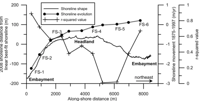
abuts the back-barrier salt marsh. This northern part of the barrier has low net decadal rates of accretion (~0.25 m/yr; Figure 2; Rodriguez et al., 2012). The central headland area has a narrow beach (~20 m wide) with a single discontinuous dune ridge <4 m in height.
Numerous washover fans extend <100 m across the dunes and the vegetation is dominated by shrub thickets but dead standing and fallen trees are frequently observed. Outcrops of peat and older sediments are exposed along the beach (Figure 1D). The beach widens significantly along the southern embayment from 20 m in the northeast to 80 m in the southwest. The discontinuous dunes are <2 m in height and washover fans can be extensive (up to 250 m wide) and extend across back-barrier marshes. This southern part of Onslow Beach has a net erosion rate of ~2 m/yr and erosion rates decrease toward the headland (Figure 2; Rodriguez et al., 2012). The variable morphology of Onslow Beach reflects its central location within Onslow Bay as it defines the border between the high-elevation regressive islands with multiple beach ridges to the north and the low-elevation, narrow transgressive islands to the south (Leatherman et al., 1979; Cleary et al. 1996).
The central headland is produced by a submarine rock ridge that intersects Onslow Beach (Riggs et al. 1995). The rock ridge is composed of the Oligocene Silverdale
Formation, a sandy, molluscan-mold limestone unit (Harris et al., 2000). The Quaternary sediment layer is thin and patchy offshore of southern and central Onslow Beach where over 50% of the inner shelf is exposed limestone (Johnston, 1997). Although Riggs et al. (1995) labeled Onslow Beach as being “sediment starved,” sandy Quaternary sediments thicken on the inner shelf from the headland towards the northeast inner shelf (Cleary and Riggs 1999).
Hurricane Fran (category 3) made landfall in September 1996 and transported 199 ± 88 x 103 m3 of sand across the back-barrier environments forming an extensive washover fan at the southern end of Onslow Beach (Foxgrover, 2009). Hurricane Bertha (category 3) arrived two months prior and likely contributed to the significant overwash of the island during Fran by lowering the dune profile. Hurricane Irene was the next large storm to strike the North Carolina coast in August 2011. Although Irene was a category 1 hurricane (wind speeds 119-153 km/h), the event caused severe shoreline erosion and the formation of washover terraces and fans along the southern and central parts of Onslow Beach.
3. METHODS
3.1 Coring
Most of the cores were obtained using the standard vibracoring method, which resulted in cores that were 0.62 m to 3.94 m in length. The vibracorer had difficulty
penetrating through the upper dry sediment, requiring hand auguring to the water table (the upper ~100 cm) at most of the sites. The augured sediment was logged in the field and the depth of the hole was recorded before vibracoring. The washover fan that formed during Hurricane Irene was sampled seven days after the storm with four cores between 43 and 65 cm in length. These short cores were collected by striking an aluminum pipe into the ground with a sledgehammer. The locations and elevations of all cores as well as topographic profiles crossing the barrier at the eleven transects were surveyed with a Trimble R8/5800 Real-Time Kinematic GPS unit. Average horizontal and vertical precisions were 0.015 m and 0.020 m, respectively.
The cores were split, photographed, described, and sampled. Interpretations of depositional environments relied on lithologies, sedimentary structures, and macrofossil assemblages. Approximately 370 subsamples were taken from the cores for grain size analyses. A 2000-µm sieve was used to determine the >2000 µm fraction and a Cilas laser particle-size analyzer for the 2000 µm to 0.04 µm component.
3.2 Radiocarbon Dating
Oceanographic Institution and Beta Analytic. All ages in this study are reported in the converted calibrated calendar years at two standard deviations obtained by using the CALIB 6.0 program (Stuiver et al., 2005).
3.3 Loss on ignition
The organic matter content of approximately 300 subsamples from the cores was measured using the loss on ignition method (Heiri et al., 2001). Subsamples were collected at 15 cm intervals or at 1 or 2 cm intervals for high-resolution analyses of the modern marsh sediment. After drying the samples overnight at 110 °C, they were burned at 550 °C in a muffle furnace for 5 hours. Percent organic matter was calculated from the dry masses measured before and after the burning stage.
4. RESULTS AND INTERPRETATIONS
4.1 Depositional Environments and Lithologic Facies
The depositional environments along Onslow Beach, including beach (foreshore and backshore), dune, washover fan, and marsh were sampled in the tops of the cores. Lithologic-facies descriptions of those modern environments were used as benchmarks to help interpret the older sedimentary units. Two units, lithologic facies A and B, were sampled at depth and were not similar to any of the modern depositional environments that exist across Onslow Beach.
The beach facies is characterized by fine to medium quartz sand (0.91-2.38 Ф) with gently-dipping heavy-mineral laminae and beds and gravelly sand beds. Swash processes in the foreshore produce the gently-dipping to parallel heavy mineral laminae and beds (Figure 3A; Davis, 1978), while the weathered shells and gravelly sand beds are the result of major reworking and transport that occurs in the high energy surf zone (Figure 3B and C; Komar, 1976). The average gravel content is 6.75% but can be as high as 41.72% within those coarse-grained beds, which were predominantly sampled in the foreshore and contain abraded Mercenaria sp., Crassostrea virginica, and Oliva sayana shells and well-rounded oblate lithoclasts. The backshore is predominantly influenced by aeolian processes, which results in finer grained and better sorted sands there than in the foreshore. The shell beds that exist in the backshore were likely emplaced during storms and subsequently winnowed by aeolian processes (Figure 3D).
The beach facies ranges in thickness from 32 cm to >204 cm (in places the core was not long enough to sample the entire thickness). Cores from the southwest end of the island commonly sampled peat rip-up clasts where this facies is thin (Figure 3E). Overall, the thickness of the beach facies decreases, and the percent gravel and the mean grain size of the sand fraction increases towards the southwest and from the toe of the foredune seaward. Rodriguez et al. (2012) also recognized those trends in sediment texture at Onslow Beach from surface-sediment samples.
Dune Facies
present but are generally only a few centimeters thick. These beds were likely emplaced during storm events and represent thin localized washover fans (Figure 4A). Plant roots and organic detritus were sampled particularly near the top of the unit where dune grasses are present (Figure 4B). Steeply dipping heavy mineral cross laminae and bedding are common sedimentary structures preserved in the cores (Figure 4B) and are typical of coastal dunes (Davis, 1978). The mean grain size of the dune sand decreases slightly towards the northeast from 1.81 Ф at cross section F1 to 2.30 Ф at cross section F6. The thickness of this unit ranges from 83 cm to >274 cm and generally increases towards the northeast.
Anthropogenically disturbed material was found at the top of three of the cores collected near roads that were constructed on the dunes (Figure 4E).
Marsh Facies
fine sand (Figure 5D and E; Staub and Cohen, 1979). Samples of the marsh facies plot near the center of the ternary diagram indicating mixed lithologies due to extreme bioturbation (Figure 6).
Washover Fan Facies
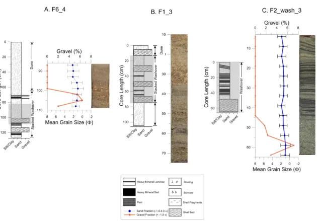
Two washover fans that formed at the southwestern end of the island were each sampled in cross-shore transects. Transect F1 sampled the washover fan that was generated fourteen years prior in September 1996 by Hurricane Fran in its surficial unit (Figure 7). The sledgehammer cores in transect F2_wash collected the washover sediments deposited in August 2011 by Hurricane Irene several days after the storm passed (Figure 8). Although the cores displayed predominantly fine sand in sharp contact with the underlying sediment, diverse hydraulic conditions resulted in lateral heterogeneity within the washover fans. The zone closer to the backshore is relatively high in elevation. It was identified as the proximal washover fan while the distal fan is described as the area adjacent to the landward margin of the fan and furthest from the breached dunes. The washover fan facies is divided into
subfacies that reflect the two zones of overwash deposition.
Figure 8. Lithological descriptions, grain size analysis, and photos of (A) ancient and (B, C) modern normal graded sand beds with abundant shells that are interpreted as proximal washover fan facies. The transect F1_3 example (B) displays the washover fan
The heavy-mineral laminae were likely deposited as the result of swash processes that followed the initial high-energy scouring. This facies is similar to the “stratified sand” and “normal-graded sand” subfacies identified by Sedgwick and Davis Jr. (2003).
Distal washover fan. This unit is light olive gray (5Y 6/1) to brownish gray (5YR 4/1) medium sand containing abundant sand-sized shell fragments. Heavy mineral sand laminae are present throughout causing grain size measurements, obtained at 2-cm intervals, to alternate between ~1.5 and 2.0 Ф (Figure 9B). This unit was likely deposited at intertidal to subtidal elevations in the distal portion of the fan which is furthest from the breached dunes and the initial impact of the storm. It has a finer grain size than the proximal washover fan, which is likely due to reworking of back-barrier sediments during the overwash event and/or lower energy distal flow conditions. Sedgwick and Davis (2003) identified this subfacies as a “bioturbated muddy sand” unit. The lack of fine sand laminae or grading within the “bioturbated muddy sand” unit was related to intense bioturbation by back-barrier species that has yet to occur within the relatively young Irene and Fran fans. Over time, rapid marsh colonization may also take place which would increase the fine sediment content, bioturbation, and organic matter content.
Facies A
two lithologically-distinct subfacies, A1 and A2
Subfacies A1. This unit is medium light gray (N6) to olive gray (5Y 4/1) sand with silty laminae and was sampled by 17 cores. The sediment is 97% sand with a mean grain size of 1.77 Ф. Flaser bedding is common in this subfacies (Figure 10A and B). Sand-sized shell fragments are common throughout the unit while gravel-sized shell fragments are only present as individual beds (Figure 10C) and can be up to 10 cm thick. These gravel beds are uncommon and were only sampled in 3 cores.
Based on the macrofauna and the flaser and gravel beds interpreted as tidal-bedding structures and tidal-channel lag deposits, respectively, this subfacies is interpreted as a marginal lagoon environment. The high sand fraction indicates bed-load transport by tidal currents and waves that can dominate the tidal flat zone (Figure 6; Davis, 1978). Sections of mud interbedded with sand are common within this facies and denote alternating bedload and suspension transport and deposition on the sand flats. Shell lag deposits imply scouring that is typically associated with tidal channels or storm deposits (Davis, 1978). This facies is currently being deposited adjacent to the barrier island in Bogue Sound, a shallow lagoon located approximately 40 km northeast of Onslow Beach (Figure 1A; Timmons et al., 2010).
The high mud content, excellent preservation of estuarine fauna, and bioturbation indicates a low-energy, central lagoon environment. Molluscs commonly colonize in reefs within low-energy areas and an oyster reef was sampled in core F1_5 (Figure 11A). Silt and fine sands accumulate from suspension while periodic high-energy tidal processes and/or storm events may deposit coarser-grained sand lenses (Davis, 1978). Sedimentary bedding is often disturbed in the central lagoon due to extensive bioturbation and reworking, resulting in a homogenous sandy mud (Reading, 1996). A silty clay unit with abundant Crassostrea virginica, similar to subfacies A2, was also sampled at the bottom of central Bogue Sound (Timmons et al., 2010).
Facies B
Facies B was sampled at the base of 14 cores and displays a wide range of textural characteristics that vary from those observed in the two lagoonal subfacies or in the modern depositional units. The cores did not penetrate the entire unit and sampled facies B sediments at variable depths that generally decrease landward and towards the southern end of the island.
This facies is primarily composed of a massive moderate yellowish brown (10 YR 5/4) sand (Figure 12A). The facies is easily distinguished from beach facies by its distinct color, finer-grained texture (mean grain size of 2.19 Φ versus 1.75 Φ for the beach facies), and poorer sorting, which is caused by a minor silt component (Figure 13). Thin beds of well-rounded quartz pebbles within greenish gray (5 G 6/1) to medium gray (N5) or
level was lower. Stiff light gray (N7) clay with yellow mottling is also indicative of oxidation and subaerial exposure (Figure 12E). Sedimentary structures and organic material were generally absent within this basal unit. Although samples from facies B were not radiocarbon dated, the homogenous, indurated, and oxidized nature of the upper part of the facies
suggests subaerial exposure and the unit is interpreted to be pre Holocene in age.
4.2 Stratigraphy
The stratigraphic cross sections through Onslow Beach show a typical transgressive facies succession within the Holocene deposits (Figure 14-23). The contact between the basal pre-Holocene unit and the overlying lagoonal mud is sharp and shows evidence of subaerial exposure and pedogenesis indicating that it is associated with a significant hiatus. This unconformity was sampled at variable depths in the along-beach direction and generally slopes seaward with high relief. It is interpreted as the sequence boundary that formed during the last sea-level lowstand. The elevation of the sequence boundary strongly controls the thickness of overlaying Holocene coastal deposits. The sequence boundary is shallow (>0 m NAVD88) in the middle of transect F2 where pre-Holocene strata outcrops in the foreshore (Figure 17) but further to the southwest and northeast, the sequence boundary is at deeper elevations and overlain by thick (>5 m) coastal deposits (Figure 14, 19-23).
presence of wood, and its superposition above the upland pre-Holocene unit. Fringing marsh on mainland shorelines represents the leading edge of the Holocene marine incursion. Roots extend into the pre-Holocene strata and radiocarbon dates of wood found at the bottom and top of this marsh/maritime forest in the Pier transect are 3556- 3728 cal years BP and 2156-2268 cal years BP, respectively (Figure 19; Table 1).
Overall, the sequence boundary deepens towards the northern end of the island which increases local accommodation and permits thick lagoon sediments to accumulate and be preserved beneath the beach facies. Where the sequence boundary is at a depth >1.25 m NAVD88 below mean sea-level, it is overlain by lagoonal sands and mud. The lagoonal unit is wedge-shaped and pinches out landward towards the modern back-barrier marsh, which is dictated by the paleo-topography of the seaward-dipping sequence boundary. Transects F1, F4, F5, and F6 show a sharp contact between pre-Holocene and lagoonal strata indicating that any fringing marsh and/or maritime forest that may have existed, was likely removed by bay-ravinement processes (Figure 14, 20-22). Thicknesses of the lagoonal facies of 224 cm or greater are common for the northern core transects (Figure 19-22), but is also observed at F3 (Figure 18) where there is a paleo-topographic low.
lagoon unit at F6 are 525-641 cal yr BP and indicate that a lagoon existed landward of Onslow Beach until at least ~ 600 years ago. Radiocarbon ages from the lagoon facies fall below the estimated relative sea-level for those time periods within the error margins (Kemp et al., 2009).
Above the lagoon unit, a discontinuous organic-rich muddy sand and peat unit, interpreted as a back-barrier marsh, was sampled. This carbonaceous unit correlates with the modern back-barrier marsh sampled at transects F1BB and F6BB. Due to compaction and decaying organic matter following burial, marsh sediments are preserved in the subsurface as dusky brown (5 YR 2/2) to black (N1) stiff carbonaceous mud with high organic matter content which is identified as peat in this study. The marsh unit is absent where lagoonal sediments are directly overlain by the extensive washover fan at F1 and the aeolian dune facies at F6. It was likely exhumed at those locations by storm and/or tidal ravinement processes (Figure 14, 22). In addition, the marsh unit is missing at F5 and F4 where it was likely removed by anthropogenic activities associated with road construction (Figure 20, 21).
which was preserved as an overlaying carbonaceous mud bed. Heavily bioturbated sediments dominate the upper portion of the washover deposit resulting in mixed sediment of fine sand and organics which increases in organic carbon content from 3% at 10 cm below the marsh unit to 20% at the contact (Figure 9A). Primary sedimentary structures, like the heavy
mineral laminae observed in the distal portion of the modern Irene fan are rarely preserved in ancient distal washover units due to intensive bioturbation (Sedgwick and Davis Jr., 2003).
The distal zone of the paleo-washover fans are absent in the modern back-barrier marsh (Figure 15 and 23) which is likely due to the protection by the dunes and to the rapid translation of the island that allows the more seaward preservation of storm beds. These beds are mainly preserved in the subsurface at the seaward margin or central portions of the transects. The corresponding proximal zone of the paleo-washover fans have been most likely excavated by erosional processes of the shoreface or from subsequent high-energy storms. The leading edge of the shoreface ravinement surface is located seaward of the dunes. It is defined by the erosional truncation of the older units that extend beneath the beach and are exposed and eroding in the surf zone which includes paleo-washover fans and the underlying facies. This surface is elevated during storms, which extends the erosional processes that lead to the destruction of dunes and old washover fans.
portions with heavy-mineral laminae and beds (Figure 8). Based on their similarity to the lithology described in the Hurricane Fran and Irene beds, they are interpreted as proximal washover deposits that have experienced some post-depositional modification. Reworking by aeolian processes following deposition likely removed some upper heavy-mineral laminae that dominated the upper decimeters of the modern proximal washover fan facies. Aeolian processes also transported dune sand to be deposit above those washover beds (Figure 8). At F1, the two proximal storm beds extend across the barrier until the layers amalgamate at the distal end of the fan, while at F6 the beds were sampled with single cores.
4.3 Timing of washover fan emplacement
Tidal currents and aeolian processes are other major mechanisms for transporting sand to the back-barrier environment during transgression but the sand layers sampled in the marsh preserved below the island are not interpreted as such. These sand beds could not have been generated within a flood-tidal delta due to the absence of deep scours and channels filled with gravel, representative of past inlets, along the island (Heron Jr. et al., 1984; Mallinson et al., 2011). Wind-blown sand lenses, which were sampled in the modern marsh, are distinguishable from washover sediments due to their finer grain size signature and overall thinness (<12 cm). Thus these beds could only have been generated by episodic washover sand deposition in a back-barrier marsh environment.
washover fan are 644-724 and 1715-1833 cal yr BP, respectively. The two shoreward cores in the adjacent transect, F3, sampled a thick landward-thinning washover fan with its basal contact at a similar elevation as the washover fan sampled at the Pier transect, which suggests deposition during the same event, or close to the same time.
Ages of the marsh sediments below and above the washover fan sampled in core F4_4 were 1293-1376 and 505-559 cal yr BP, respectively, and the washover fan sampled in core F2strike_4 were 560-598 and 280-318cal years BP, respectively (Table 1). At the seaward margin of F1, two distinct washover fans were sampled in the same core. The base of the lower washover fan has a similar elevation as the top marsh layer in nearby-core F2strike_4, and is assumed to have been deposited during the same time period (280-318 cal yr BP; Table 1). The age of the top washover fan was constrained from plant material in the underlying marsh layer, which was deposited within the last 77 years (post-bomb
radiocarbon age). Washover fans were also sampled towards the middle of the island at transects F5, Pier, and F2. Our 14C data of the marsh sediments directly underlying the fans sampled in cores Pier_5 and F5_5 show that they were deposited by storm events within the 19th century. The washover fan sampled in core F2_7 was likely deposited in the 20th century based on a radiocarbon date of 55-145 cal yr BP from wood sampled at the base of the marsh/maritime forest unit sampled in core F2_5 that is ~50 cm below the base of the washover fan.
5. DISCUSSION
Similar to its geomorphology, the internal facies architecture varies along Onslow Beach which suggests that the transgressive history of the barrier island system was not uniform along the island (Figure 24). Accommodation controlled by the antecedent geology plays a large role in the type of environment that is deposited and preserved above the sequence boundary. Sediment deposition was influenced by high-elevation pre-Holocene strata at the southern end of Onslow Beach that correlates with the submarine limestone headland exposed on the inner shelf. The Holocene record at that region is generally thin due to the low accommodation, except at F3 in which a more complete sedimentary record is preserved in a paleo-channel (Figure 18 and 24). Lowstand fluvial channels similar to the paleo-channel that intersects the island at F3 are commonly observed in seismic data collected across adjacent barriers like Bogue Banks to the north (Timmons et al., 2010) and Wrightsville Beach to the South (Thieler et al., 2001).
marsh samples from above the lagoon facies in the seaward margin of transects F4 and Pier were radiocarbon dated as 1293-1376 cal yr BP and 1715-1832 cal yr BP , respectively, indicating a lagoon existed at the northern part of the study area for >1000 years before the southern area of Onslow Beach was inundated. The variable timing of back-barrier lagoon emplacement along the island is a consequence of the greater accommodation (lower elevation pre-Holocene surface) at the northern end of the region.
Similar to the along-strike difference in the evolution of the back-barrier environment the timing of island transgression was also variable along the barrier. Holocene migration rates were estimated along the island by approximating the position of the shorelines associated with the paleo-washover fans. The paleo-shoreline was projected a constant distance seaward from the landward extent or pinch-out of each paleo-washover deposit. The location of pinch-out was estimated to be midway from the core that sampled the deposit and the adjacent landward core where evidence of the storm event is absent. Only distal washover fans were utilized due to their proximity to the pinch out. The constant width of a washover fan (185 m) was determined by the median width of the fans deposited by the modern Hurricanes Fran (302 m) and Irene (68 m). Hurricane Fran was a Category 3 storm and displaced a greater amount of sediment than the Category 1 Irene. The distance between the calculated shoreline and the modern shoreline divided by the time that the paleo-washover fan was emplaced yields the long-term shoreline retreat rate. Using a constant value for the distance between the landward pinch out of the washover fans and the
distribution of paleo-washover fans along the entire island, however, calculating the rate with a consistent method will reveal spatial and temporal (centennial) trends in the absence of data on past island width and morphology.
Rates of shoreline retreat calculated from washover fans that were deposited along the island at similar times were analyzed together to examine along-beach variations in shoreline movement due to geologic factors. For example shoreline-retreat rates calculated from a washover fan that formed 1800 years ago was not compared to shoreline-retreat rates calculated from a washover fan that formed 200 years ago because the rate of sea-level rise and storminess were likely different. The three washover fans that formed over the past ~50-150 years are located at the southern, central, and northern zones of the island and shoreline migration rates derived from these features were compared. The resulting rates of shoreline transgression in the southern (transect F2) and central (Pier) sections of the island were ~ 0.77 and 0.36 m/yr, respectively, which is similar to the modern average rates of shoreline retreat for those sections (~2.0 – 0.5 m/yr and 0.5 – 0 m/yr, respectively). The northern section represented by transect F5, transgressed at a rate of 0.03 m/yr which contrasts with its modern rate of shoreline seaward advance of 0.25 m/yr. Rapid transgression in the southern part of Onslow Beach likely overstepped the older lagoonal deposits. Due to the slower rates of transgression in the central and northern parts of the island, lagoon sediments in those regions were preserved below the modern beach. Alongshore variability in shoreline
Onslow Beach exhibited rapid landward retreat via recurring overwash events along the entire length of the island during the late Holocene. The three oldest paleo-washover fans preserved below the beach are interpreted to record evidence of an island located seaward of the current Onslow Beach. The southern section contains two storm deposits that occurred between ~300 to 600 cal yr BP while the central section preserved a paleo-washover fan that is older and up to ~1800 cal yr BP. Washover fans are unlikely to occur today on the
northern end of the island due to the high-elevation continuous dune line but washover features are preserved at this region. This suggests that the entire barrier had a low profile in the past and was susceptible to overwash during high-energy events. These storm impacts on the more robust northern end of the island, however, only resulted in the deposition of proximal washover fan facies which are unable to be radiocarbon dated. The older paleo-washover fans in the younger southern section indicate that the entire island had transgressed to its current location by at least ~300 to 600 cal yr BP.
The overwash-dominated barrier islands of southern Onslow Bay that comprise the high-energy flank of the Cape Fear foreland (east facing; Cleary and Hosier, 1979) have a similar but slightly older transgressive history than Onslow Beach. Radiocarbon ages of peat sampled beneath Masonboro Island, southwest of Onslow Beach, are 902-1066 and 545-797 cal yr BP. These ages are slightly older than the dates determined from the peat underlying Onslow Beach but reveal a similar rapid transgressive history. The inner shelf of
southwestern Onslow Bay is also sediment-starved and dominated by rock outcrops (Thieler et al., 2001), similar to the southern end of Onslow Beach.
barrier islands on the lower energy limb south of Cape Lookout such as Bogue Banks, have a history of progradation as evidenced by a higher, wider profile with multiple beach ridges and less accounts of inlets and washover fans (Cleary and Hosier, 1979; Heron Jr. et al. 1984; Timmons et al., 2010). The oldest beach ridge on Bogue Banks formed ~3300 years ago and lagoon sediments sampled in the center of Bogue Sound are ~5500 cal yr BP. The island prograded seaward until ~1200 cal yr BP, in part by incorporating reworked paleo-channel-fill deposits on the shelf (Timmons et al., 2010). From previous work, the northeastern barriers along Onslow Bay retreated at a slow rate, migrated a short distance and reached their current positions ~3000 yeas ago, while the southeastern barriers rapidly transgressed large distances to their current positions within the last ~1000 years. Onslow Beach, located centrally in the bay, is interpreted from this study to have the most rapid migration rate in the bay, arriving to its modern location ~600 years ago.
These empirical data support the numerical model formulated by Ashton et al. (2001). That model is based on an instability mechanism induced by gradients in alongshore
5.2 Storm Impacts
The suite of preserved washover fans along the island suggests that storms played an important role in the evolution of Onslow Beach over at least the last ~1800 years. To analyze the record of significant overwash events, the timing of emplacement and landward pinch out of the distal paleo-washover fans, measured against a baseline, were compared. The best-fit linear regression through the 2006 digitized Onslow Beach shoreline was used as the baseline which acts as a control on the paleo-shoreline position and provides a straight shoreline for the study. Older washover fans are positioned closer to the baseline than younger washover fans, which is consistent with transgressive barrier island sequences (Figure 25). Figure 25 shows that the landward pinch-out distance of washover fans increases exponentially in recent time. More washover fans formed along Onslow Beach over the last 100 years (five washover fans) than the preceding 1650 years (three washover fans). The recent fans extend two to four times farther landward than the older washover fans. If the plot of the landward pinch out of washover fans through time was linear and it would indicate a steady rate of island transgression. The exponential trend could be the result of changes in island morphology (e.g. sediment supply or dune height), storm severity and frequency, and/or acceleration in the rate of sea-level rise.
Figure 25. Estimated landward extent of the distal washover fans plotted with their
can be interpreted as the result of stronger storms or a weaker island. All of the washover fans plotted on Figure 25 impacted the back-barrier environment of the paleo-barrier suggesting that deposition was the result of storm events with intensities equivalent to the recent Hurricanes Fran and Irene. Smaller storm events can overwash the island, but typically only impact the dune or older washover fans as proximal washover fans, similar to those sampled in dune and washover facies in transects F6 and F1, respectively. Thus, the exponential trend is not likely due to differences in storm severity in the past ~2,000 years. Alternatively, Onslow Beach may have been less susceptible to overwash in the past due to a higher elevation or greater width which would cause less washover fans during that time. Currently, the northeastern region is robust and is protected with multiple high dune ridges. Those dune ridges, however, were still degraded by at least one paleo-storm. Transect F5 in the northern region contains one of those recent paleo-washover fans indicating that
morphology is not a factor in the pattern of preserved storm deposits. This fan also suggests that high dunes can accrete or erode rapidly at centennial timescales. The curve in Figure 25 is not likely due to severity of the individual storm or morphology of the island.
such a rapid rate that it decreased the preservation of the washover fans due to major island degradation from storm impact. The earliest washover events preserved in our sedimentary record, which occurred prior to the stormy period (transects F3, Pier, and F4_4), may have been generated by an extremely intense storm that occurred before the rapid transgression during the MWP. Another possible explanation for the lack evidence of the MWP on Onslow Beach is that the resultant washover fans may have been emplaced between our transect sites and were not sampled.
Many have speculated that the Little Ice Age (~550-50 cal yr BP; LIA) was another period of greater storms that impacted the Atlantic coast. During the last ~150 years, a greater frequency of washover events as well as an increase in the distance of the landward extent of the resultant fans occurred along Onslow Beach. The apparent rapid transgression of the island during this period falls within the Little Ice Age, which is a time when
nor’easters along the U.S. Atlantic coast may have been more intense (Mallinson et al., 2011). Increased nor’easters during the Little Ice Age has been concluded to have formed large inlet complexes along the northern Outer Banks coastline. Most of those inlets, however, formed around 300-400 cal yr BP, which is at least 150 years earlier than the washover fans preserved along Onslow Beach. In addition, Onslow Beach is southeast facing and thought to be impacted less from nor’easters than the Outer Banks north of Cape
Hatteras, which are facing east-northeast (Mallinson et al., 2011). Despite the later dates of washover fan generation on Onslow Beach and the difference in orientation in comparison to the northern Outer Banks, the LIA likely had more of an effect than the MWP on the
Although intense storm periods may have played a role in the increased number and landward extent of washover fans emplaced along Onslow Beach over the last ~150 years, the rate of relative sea-level rise also increased at that time and may have had a greater influence. For the last ~130 years ago, the mean rate of relative sea-level rise was 2.9 mm/yr, which was greater than the last 2000 years (Kemp et al., 2011). The increase in the rate of sea-level rise at AD 1865-1892 coincides with deposition of three paleo-washover fans along the island. The rapid rise in sea-level likely increased the rate that the open-ocean and back-barrier shorelines were moving landward and the associated rate of island transgression. In addition, increased rates of transgression likely maintained a low-island elevation, making it more susceptible to overwash. The most frequent deposition of storm beds occurred in the last 150 years and can be linked to the abrupt rise in rate of sea-level. The slow rate of transgression suggested from the older paleo-washover fans prior to this period corresponds with the stable or low rate of sea-level rise (Kemp et al., 2011).
A model simulation of the cumulative effects of increased tropical and extra-tropical storms, incorporating a greater proportion of high-angle waves, predicts that cuspate bays will erode at increased rates while the cape tips will accrete (Slott et al. 2006). In response to the increase in storminess during the Medieval Warm Period, an increase in the number of washover fans was not seen along Onslow Beach. Bogue Banks, located on the southern flank of Cape Lookout, experienced rapid erosion of the back-barrier shoreline during the Medieval Warm Period that caused the island to narrow at its center (Timmons et al. 2010). Bogue Banks was destructively impacted on its lagoon side by periods of increased storms; however, it is unclear if the ocean shoreline experienced accretion as predicted by the
at Bogue Banks was not correlated with periods of intense storm climate such as the MWP and LIA as predicted by the Slott et al. (2006) model.
Discrepancies between the Slott et al. (2006) model and coastal impacts from increased storminess along Onslow Bay may result from the assumptions built into the model. Slott et al. (2006) modeled the cumulative coastal effects of increased storm activity assuming (1) a mainland shoreline; (2) wave-driven alongshore forcing as the mechanism for sediment transport; (3) the seafloor is composed of unconsolidated sand and (4) sea-level is constant. In the barrier-lagoon complexes that dominate the North Carolina coast, the significant role of cross-shore sediment transport is evident in the abundant relict washover fans and tidal inlets that many studies have mapped (Mallinson et al. 2011; Davis, 1994; Moslow and Heron Jr. 1978). Overwash and inlet processes are two primary mechanisms that control island widening and the removal of sediment from the active littoral zone and
deposition into the back-barrier environment. Shore-perpendicular processes, which Slott et al. (2006) did not factor into their model, are driven by rising sea-level and storms.
paleo-channel fill was the primary mechanism that promoted accretion during slow sea-level rise for Bogue Banks (Timmons et al., 2010) rather than sediment transport driven by high-angle waves.
6. CONCLUSIONS
Onslow Beach is a transgressive barrier island that retreated landward during the late Holocene primarily through overwash processes and washover fan formation. Nine paleo-washover fans that impacted the coeval back-barrier marsh were preserved below the modern beach or dune as opposed to the modern back-barrier marsh environment. Older deposits were sampled below the modern beach and revealed the time of emplacement of the barrier island. The oldest washover deposits, which were preserved in the central region of the island, are ~1800 cal yr BP and suggests that the island was proximate to its present position since that time. During this period, the northern region of Onslow Beach was likely separated from the mainland by an open-water lagoon. Due to the shallow pre-Holocene surface in the southern end, this region was inundated approximately 800 years later. The barrier island in the southern region transgressed after the northern part of the island was emplaced. The oldest washover fans at the southern end of the island were deposited approximately 600 cal yr BP and indicate that the entire island reached its present position fairly recently with variable migration rates along the island. Antecedent topography plays a significant role in shoreline transgression which varies along the island on millennial and centennial timescales.
Bogue Banks in northeastern Onslow Bay which was formed ~3300 cal yr BP. As the morphology of the coastline implies, barriers located at the center of a coastal embayment such as Onslow Beach transgressed more rapidly and a longer distance across the continental shelf than barriers located along the cape flanks (Bogue Banks), given a straight shoreline during the sea-level lowstand. Along with the Masonboro Island and Bogue Banks studies, the stratigraphy of Onslow Beach provides geologic evidence for the numerical model of Ashton et al. (2001) and Ashton and Murray (2006).
location at the center of a coastal embayment, its underlying geology that dictates regional accommodation and its lack of sand on the inner continental shelf (Riggs et al., 1995).
Although North Carolina barrier islands have been impacted by periods of more intense storms such as the MWP and the LIA, washover fans deposited on Onslow Beach do not correlate with these periods. A possible explanation for stormy periods not being
recorded in the sedimentary record of Onslow Beach is that the dunes are able to recover rapidly after storm events, Nor’easters associated with the LIA have less of an erosive impact on south facing shorelines, and a possible low preservation of storm deposits that may have formed during the MWP.
REFERENCES
Abbe, C.J. (1895). Remarks on the cuspate capes of the Carolina Coast. Boston Society of Natural History Proceedings 26, 489-497.
Andrews, J. (1992). A Field Guide to Shells of the Texas Coast (Gulf Publishing Company). Ashton, A., Murray, A.B., and Arnault, O. (2001). Formation of coastline features by large-scale instabilities induced by high-angle waves. Nature 414, 296–300.
Ashton, A.D., and Murray, A.B. (2006). High-angle wave instability and emergent shoreline shapes: 1. Modeling of sand waves, flying spits, and capes. J. Geophys. Res. 111, 19 PP. Belknap, D.F., and Kraft, J.C. (1985). Influence of antecedent geology on stratigraphic preservation potential and evolution of Delaware’s barrier systems. Marine Geology 63, 235– 262.
Benton, S.B., Bellis, C.J., Knisel, J.M., Overton, M.F., and Fisher, J.S. (2004). 1998 Long-term average annual erosion rate update: Methods Report. North Carolina Division of Coastal Management, North Carolina Coastal Resources Commission.
Cleary, W.J., and Hosier, P.E. (1979). Geomorphology, washover history and inlet zonation: Cape Lookout, to Bird Island( North Carolina). Barrier Islands: from the Gulf of St.
Lawrence to the Gulf of Mexico, 237-271.
Cleary, W.J., Riggs, S.R., Marcy, D.C., and Snyder, S.W. (1996). The influence of inherited geological framework upon a hardbottom-dominated shoreface on a high-energy shelf: Onslow Bay, North Carolina, USA. Geological Society Special Publication 117, 249-266. Cleary, W.J. and Riggs, S.R. (1999) Beach erosion and hurricane protection plan for Onslow Beach, Camp Lejeune, NC. Comprehensive geologic characteristics report prepared for US Marine Corps Camp Lejeune, NC, 150 pages.
Cronin, T.., Dwyer, G.., Kamiya, T., Schwede, S., and Willard, D.. (2003). Medieval Warm Period, Little Ice Age and 20th century temperature variability from Chesapeake Bay. Global and Planetary Change 36, 17–29.
Culver, S.J., Grand Pre, C.A., Mallinson, D.J., Riggs, S.R., Corbett, D.R., Foley, J., Hale, M., Metger, L., Ricardo, J., Rosenberger, J., Smith, D.G., Smith, C.W., Snyder, S.W., Twamley, D., Farrell, K., and Horton, B.P., (2007). Late Holocene barrier island collapse: Outer Banks, North Carolina, USA. The Sedimentary Record, 5, 4-8.
Davis, R.A. (1978). Coastal sedimentary environments (Springer-Verlag).
Demarest, J.M. and Leatherman, S.P. (1985). Mainland influence on coastal transgression: Delmarva Peninsula. Marine Geology 63, 19-33.
Donnelly, J.P., Butler, J., Roll, S., Wengren, M., and Webb, T. (2004). A backbarrier overwash record of intense storms from Brigantine, New Jersey. Marine Geology 210, 107– 121.
Evans, M.W., Hine, A.C., Belknap, D.F., and Davis Jr., R.A. (1985). Bedrock controls on barrier island development: West-central Florida coast. Marine Geology 63, 263–283. Foxgrover, A.C. (2009) Quantifying the overwash component of barrier island
morphodynamics: Onslow Beach, NC. Master's Thesis, College of William and Mary, 163 pages.
Gulliver, F.P. (1896). Cuspate forelands. Geological Society of America Bulletin 7, 399-422. Harris, W.., Mendrick, S., and Fullagar, P.. (2000). Correlation of onshore–offshore
Oligocene through lower Miocene strata using 87Sr/86Sr isotopic ratios, north flank of Cape Fear Arch, North Carolina, USA. Sedimentary Geology 134, 49–63.
Heiri, O., Lotter, A.F., and Lemcke, G. (2001). Loss on ignition as a method for estimating organic and carbonate content in sediments: reproducibility and comparability of results. Journal of Paleolimnology 25, 101-110.
Heron Jr., S.D., Moslow, T.F., Berelson, W.M., Herbert, J.R., Steele III, G.A., and Susman, K.R. (1984). Holocene sedimentation of a wave-dominated barrier island shoreline: Cape Lookout, North Carolina. Marine Geology 60, 413–434.
Hoyt, J.H., and Henry, V.J. (1967). Influence of Island Migration on Barrier-Island Sedimentation. Geological Society of America Bulletin 78, 77–86.
Hoyt, J.H., and Henry, V.J. (1971). Origin of capes and shoals along the southeastern coast of the United States. Geological Society of America Bulletin 82, 59-66.
Johnston, M.K. (1997). The inherited geologic framework of the New River submarine headland complex, North Carolina, and its influence on modern sedimentation. Master's Thesis, University of North Carolina, Wilmington, 166 pages.
Kemp, A.C., Horton, B.P., Donnelly, J.P., Mann, M.E., Vermeer, M., and Rahmstorf, S. (2011). Climate related sea-level variations over the past two millennia. Proceedings of the National Academy of Sciences 108, 11017–11022.
Komar, P.D. (1976). Beach processes and sedimentation (Prentice-Hall).
Leatherman, S.P., Section, G.S. of A.N., and Section, S. of E.P. and M.E. (1979). Barrier islands from the Gulf of St. Lawrence to the Gulf of Mexico (Academic Press).
Leatherman, S.P., and Williams, A.T. (1983). Vertical sedimentation units in a barrier island washover fan. Earth Surface Processes and Landforms 8, 141–150.
Mallinson, D.J., Smith, C.W., Culver, S.J., Riggs, S.R., and Ames, D. (2010a). Geological characteristics and spatial distribution of paleo-inlet channels beneath the Outer Banks barriers islands, North Carolina, USA. Estuarine, Coastal and Shelf Science 88, 175-189. Mallinson, D.J., Smith, C.W., Mahan, S., Culver, S.J., and McDowell, K. (2011). Barrier island response to late Holocene climate events, North Carolina, USA. Quaternary Research
76, 46–57.
Mann, M.E., Woodruff, J.D., Donnelly, J.P., and Zhang, Z. (2009). Atlantic hurricanes and climate over the past 1,500 years. Nature 460, 880-883.
Mayewski, P.A., Rohling, E.E., Curt Stager, J., Karlén, W., Maasch, K.A., David Meeker, L., Meyerson, E.A., Gasse, F., van Kreveld, S., Holmgren, K., et al. (2004). Holocene climate variability. Quaternary Research 62, 243–255.
McNinch, J.E., and Wells, J.T. (1999). Sedimentary processes and depositional history of a cape-associated shoal. Continental Shelf Research 20, 2367-2389.
Moslow, T.F., and Heron, S.D.,(1978). Relict inlets; preservation and occurrence in the Holocene stratigraphy of southern core banks, North Carolina Journal of Sedimentary Research 48, 1275-1286.
Pierce, J.W., and Colquhoun, D.J. (1970). Holocene Evolution of a Portion of the North Carolina Coast. Geological Society of America Bulletin 81, 3697 –3714.
Reading, H.G. (1996). Sedimentary environments: processes, facies, and stratigraphy (John Wiley & Sons).
Riggs, S.R., Cleary, W.J., and Snyder, S.W. (1995). Influence of inherited geologic
framework on barrier shoreface morphology and dynamics. Marine Geology 126, 213-234. Riggs, S.R., and Belknap, D.F. (1988) Upper Cenozoic processes and environments of continental margin sedimentation: eastern United States: in R.E. Sheridan and J.A. Grow ,eds., Geology of North America, v. 1-2, The Atlantic Continental Margin: U.S., The Geological Society of America, p. 131-176.
Rodriguez, A.B., Rodriguez, P.L., and Fegley, S.R. (2012). One-year along-beach variation in the maximum depth of erosion resulting from irregular shoreline morphology. Marine Geology 291–294, 12–23.
Scott, D.B., Collins, E.S., Gayes, P.T., and Wright, E. (2003). Records of Prehistoric Hurricanes on the South Carolina Coast Based on Micropaleontological and
Sedimentological Evidence, with Comparison to Other Atlantic Coast Records. Geological Society of America Bulletin 115, 1027–1039.
Sedgwick, P.E., and Davis Jr., R.A. (2003). Stratigraphy of washover deposits in Florida: implications for recognition in the stratigraphic record. Marine Geology 200, 31–48. Slott, J.M., Murray, A.B., Ashton, A.D., and Crowley, T.J. (2006). Coastline responses to changing storm patterns. Geophysical Research Letters 33,.
Staub, J.R., and Cohen, A.D. (1979). The Snuggedy Swamp of South Carolina; a Back-Barrier Estuarine Coal-Forming Environment. Journal of Sedimentary Research 49, 133–143. Stuiver, M., Reimer, P. J., and Reimer, R. W. (2005). CALIB 5.0. [WWW program and documentation].
Stuiver, M., and Reimer, P. J., (1993). Extended 14C database and revised CALIB radiocarbon calibration program, Radiocarbon 35, 215-230.
Thieler, E.R., and Ashton, A.D. (2011). “Cape capture”: Geologic data and modeling results suggest the Holocene loss of a Carolina Cape. Geology 39, 339–342.
Thieler, E.R., Pilkey, O.H., Cleary, W.J., and Schwab, W.C. (2001). Modern Sedimentation on the Shoreface and Inner Continental Shelf at Wrightsville Beach, North Carolina, U.S.A. Journal of Sedimentary Research 71, 958–970.
Timmons, E.A., Rodriguez, A.B., Mattheus, C.R., and DeWitt, R. (2010). Transition of a regressive to a transgressive barrier island due to back-barrier erosion, increased storminess, and low sediment supply: Bogue Banks, North Carolina, USA. Marine Geology 278, 100– 114.
Toumey, M. (1848). Report on geology of South Carolina. (A.S. Johnson)
Valvo, L.M., Murray, A.B., and Ashton, A. (2006a). How does underlying geology affect coastline change? An initial modeling investigation. J. Geophys. Res. 111, 18 PP.
Wilkinson, B.H., and Basse, R.A. (1978). Late Holocene History of the Central Texas Coast from Galveston Island to Pass Cavallo. Geological Society of America Bulletin 89, 1592– 1600.