Centre for Advanced Spatial Analysis University College London
1-19 Torrington Place Gower Street
London WC1E 6BT [t] +44 (0) 20 7679 1782 [f] +44 (0) 20 7813 2843 [e] [email protected] [w] www.casa.ucl.ac.uk
http//www.casa.ucl.ac.uk/paper31.pdf Date: April2001
ISSN: 1467-1298
© Copyright CASA, UCL.
Paper presented at the Annual Association of American Geographers Meeting, New York City, March, 2001. (Originally and inspirationally entitled, ‘A hybrid geocomputation model for operational land-use and transport simulation.)
ABSTRACT
There are indications that the current generation of simulation models in practical, operational uses has reached the limits of its usefulness under existing specifications. The relative stasis in operational urban modeling contrasts with simulation efforts in other disciplines, where techniques, theories, and ideas drawn from computation and complexity studies are revitalizing the ways in which we conceptualize, understand, and model real-world phenomena. Many of these concepts and methodologies are applicable to operational urban systems simulation. Indeed, in many cases, ideas from computation and complexity studies—often clustered under the collective term of geocomputation, as they apply to geography—are ideally suited to the simulation of urban dynamics. However, there exist several obstructions to their successful use in operational urban geographic simulation, particularly as regards the capacity of these methodologies to handle top-down dynamics in urban systems.
This paper presents a framework for developing a hybrid model for urban geographic simulation and discusses some of the imposing barriers against innovation in this field. The framework infuses approaches derived from geocomputation and complexity with standard techniques that have been tried and tested in operational land-use and transport simulation. Macro-scale dynamics that operate from the top-down are handled by traditional land-use and transport models, while micro-scale dynamics that work from the bottom-up are delegated to agent-based models and cellular automata. The two methodologies are fused in a modular fashion using a system of feedback mechanisms. As a proof-of-concept exercise, a micro-model of residential location has been developed with a view to hybridization. The model mixes cellular automata and multi-agent approaches and is formulated so as to interface with meso-models at a higher scale.
1. Introduction
As the field of urban simulation moves into a state of maturity, it is noteworthy that the pace of change in model development appears relatively sluggish. Models in practical use today do not seem much changed from those in use ten or even twenty years ago (with the exception, of course, of models developed in academic circles; but, even there, there is much room for improvement). There are signs that the current generation of urban models in operational uses has reached the limits of its usefulness under existing specifications. This proposition is unremarkable when we draw comparisons with other fields that have been established for a number of decades; new avenues of exploration dwindle, leaving little room for innovation. It is surprising, however, in the field of operational urban simulation, where cities are evolving and adapting at a pace that outstrips our capacity to study them in theoretical terms, let alone to model them. In short, the time is ripe in urban systems simulation for the infusion of new ideas.
geocomputation—offer the potential for a ‘revolution’ in the way we model urban systems.
However, there exist several significant barriers to the successful use of these new tools in operational urban simulation. If ignored, these obstacles could doom these new ideas to a fate reminiscent of earlier waves of large-scale urban modeling (Torrens & O'Sullivan, 2001). And importantly, ‘traditional’ urban simulation models still have a great deal to offer operational planning applications.
This paper describes a relatively new approach to operational urban simulation; it describes a hybrid geocomputation model designed to support the exploration of ‘what-if’ scenarios for urban planning, urban management, and public policy formation. The hybrid approach fuses ‘traditional’ simulation methodologies that operate at macro- and meso-levels with a ‘new wave’ of geocomputation methodologies at a micro-scale. To demonstrate some of the practicalities of building hybrid models, a prototype residential location simulation is developed, fusing cellular automata and multi-agent systems at the micro-scale and designed to interface with meso-models at higher scales.
2. ‘Traditional’ urban models
2.1. Centralized approaches
The core components of ‘traditional’ land-use and transport models leaned heavily— in a theoretical sense—on ideas about the city that stemmed from the Chicago School of urban studies (Carter, 1981). These theories were formulated, for the most part, in a time in which cities were quite different than their current manifestations. In terms of activity, the conceptualization of cities was that they were largely dominated by centralized modes of production. Structurally, cities were considered to be monocentric, organized with a dominant and often singular center that was surrounded by satellites of nucleated activity that orbited on the periphery, dispersing monotonically with distance from the urban core.
Several techniques in ‘traditional’ urban simulation mirror this centralized conceptualization of urban systems. The spatial interaction (or gravity) framework, in particular, is heavily dependent on the idea of a centralized city. In a spatial interaction model, activity in an urban system is formulated as a series of flows or exchanges (usually trips) between origin and destination zones in a city based proportionally on the ‘mass’ or attractiveness of a given zone (e.g., population or employment) (Fotheringham & O'Kelly, 1989).
Of course, the centralized approach is not really appropriate for many cities, particularly large cities. Urban areas are becoming increasingly decentralized in terms of activity and structure. As cities have grown progressively reliant on service economies, the importance of the central city as the core of activity has waned considerably. Largely with the exception of activities that really rely on face-to-face contact, activities are increasingly locating in and relocating to suburban and fringe locations, paralleling residential location trends.
and distributed manner; some techniques in geocomputation can offer this functionality.
2.2. Dynamics
In order to be truly useful—whether for operational uses or just for exploring ideas— an urban simulation should really incorporate dynamic functionality. Models should be capable of capturing cities’ abilities to evolve over time. Generally, dynamics are poorly represented in operational urban simulations. Dynamics usually enter models in an indirect and implied sense. Cross-sectional data are commonly used as a proxy for dynamics. These data are collected for a single period in time: a snapshot. Clearly, this is a poor substitute, but is often the only available option. Other models are developed with longitudinal data, offering a series of snapshots, often separated by long periods of time with little information about the intervening period, e.g., data from the Census, which is reported on a ten-year basis. While longitudinal data are much richer in the information they convey, they still constitute a weak proxy for dynamics—a lot can happen in a city in ten years!
Ideally, dynamics would feature more explicitly in a simulation, with system dynamics evolving in real or near-real time (see Gleick, 2000, for an interesting debate about what constitutes real time!). Some of the geocomputation techniques that we will discuss later incorporate dynamics in a more realistic manner and offer significant advantages over ‘traditional’ techniques.
2.3. Detail
‘Traditional’ land-use and transport models are weak in handling detail. For the most part, this is due to a lack of data available at fine-scale resolutions. There are two important attributes of detail to be considered when developing an urban simulation: spatial resolution and socioeconomic aggregation.
fallacy and modifiable areal unit problems (Openshaw, 1983). Because many of the processes that ‘make cities work’ operate at finer resolutions, this lack of detail may, in some cases, be regarded as a serious limitation of ‘traditional’ models.
The second important point when considering detail is socioeconomic aggregation. ‘Traditional’ models commonly represent discrete socioeconomic groupings in a city in a relatively aggregated manner. In many cases, model developers would do well to disaggregate the representation of various components such as households, land-use categories, and employment types. Households could be nested into several socioeconomic groupings, land-use into a more diverse range of activities, and employment into a wider collection of sectors. Essentially, this involves a microsimulation of urban systems.
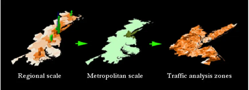
Figure 1. Spatial resolution in ‘traditional’ urban simulation models: Megalopolis and the New York Metropolitan Statistical Area.
2.4. Usability
It is vitally important that operational land-use and transport models are developed with the end-user in mind. In particular, models should be developed in such a way that makes them easier for decision-makers and the public to digest. Usability has long been a concern in other areas of applied science (e.g., human-computer interaction in computing; see Preece, 1994), but has often been weakly addressed in operational urban simulation. In many cases, users perceive simulations as ‘black boxes’: inputs are fed into the model and the results of calculations and operations are output, but the inner workings of the model may remain a mystery. This acts as a barrier to the efficient and appropriate use of models as decision support systems and impairs the ability of models to serve as exploratory tools.
2.5. Flexibility
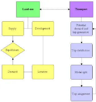
There are two important aspects of flexibility of relevance to urban simulation: scaling and modularity. It is important that land-use and transport models cater to a wide variety of scales, ideally in an integrated and seamless manner that is capable of representing the phenomena that shape urban areas at all levels from global through to local scales. As we have seen, ‘traditional’ models are weak in their handling of micro-scale phenomena. In terms of software engineering, land-use and transport models are generally rendered more flexible when they are modularized into a set of sub-models (each of which could deal with a particular subset of an urban system) and constituent components that can be tested independently (the compartmentalization of land-use and transport activity is a prime example; figure 2). There are techniques in geocomputation that can better facilitate modularization and lend models greater flexibility. The expression of models in object-oriented terms, in particular, offers the potential for an improved level of flexibilty (Noth, Borning, Waddell, 2000).
2.6. Realism
‘traditional’ models run in the wrong direction! Once again, there are some techniques in geocomputation that can help to remedy these deficiencies.
3. A ‘new wave’ of urban models
The discussion of ‘traditional’ models and their weaknesses sets the stage for the introduction of a ‘new wave’ of urban models, which we might denote as ‘complexity models’, ‘geosimulation models’, or more generally as ‘geocomputation models’. These models are in their relative infancy as applied to urban simulation and constitute a new class of simulation tools that borrow heavily from developments in geographic information science, artificial intelligence and artificial life, complexity studies, and simulation in natural sciences and social science outside of geography. While the use of computers and computation in urban simulation is by no means new, the geocomputation approach—modeling systems at the scale of individuals and entity level units of the built environment—is particularly innovative from an urban simulation standpoint.
3.1. Advances in geographical information science
Figure 2. Specification of a ‘traditional’ land-use and transport model.
3.2. Object-oriented programming
the advantage of allowing model developers to focus on the program as a simulation rather than as a piece of software. Indeed, several object-oriented modules have been developed specifically for geographic software (Centre for Computational Geography; Box, 2001), and object-oriented code for entire land-use and transport models has been published in the public domain (Waddell, 2000a).
3.3. Complexity studies
Complexity studies are closely related to chaos theory (Gleick, 1987). The main idea in complexity is that of emergence. In emergent systems, a small number of rules or laws, applied at a local level and among many entities are capable of generating surprising complexity and often ordered patterns in aggregate form. Additionally, these systems are dynamic and change over time without the direction of a centralized executive. Complex patterns manifest themselves in such a way that the actions of the parts do not simply sum to the activity of the whole (Holland, 1998). Essentially, this means that there is more going on in the dynamics of the system than simply aggregating little pieces into larger units.
Examples of emergent systems abound. For example, the liquidity of water is more than a simple extrapolation of characteristics that can be attributed to individual water molecules, which have no liquid quality in isolation (Krugman, 1996). Many urban systems are also complex in this sense. From the local-scale interactive behavior (commuting, moving) of many individual objects (vehicles, people), structured and ordered patterns emerge in the aggregate, such as peak-hour traffic congestion (Nagel, Rasmussen, Barrett, 1996) and the large-scale spatial clustering of socioeconomic groups by residence (Benenson, 1998). In urban economics, large-scale economies of agglomeration and disagglomeration have long been understood to operate from local-scale interactive dynamics (Krugman, 1996). Also, cities exhibit several of the signature characteristics of complexity, including fractal dimensionality and self-similarity across scales, self-organization, and emergence (Batty & Longley, 1994; Allen, 1997; Portugali, 2000).
urban systems. The ideas also suggest that the answer to questions of the form, ‘How do cities work?’ might find new answers among the myriad and evolving interactions of individuals and the urban spaces that they inhabit. This is a much more generative approach than the reductionist view that is traditionally adopted in urban studies. Simply dissecting cities may not provide all the answers; on the contrary, there may be a need to build them up from the bottom and in doing so we may learn a lot about how they work. This may have some direct analogies in urban simulation also; indeed there are modeling techniques in geocomputation that work exactly on these principles, chiefly cellular automata (CA) and multi-agent systems (MAS).
3.4. Cellular automata and multi-agent systems
In terms of urban simulation, CA are perhaps best used to represent the dispersal of activity and characteristics between discrete spatial units of urban infrastructure. MAS may be more suited to simulating urban population as collectives of individuals with associated behaviors and traits and the capacity for spatial mobility and communication.
Neighborhoods are the localized regions of a CA lattice (collections of cells), from which automata draw input. Neighborhoods in an urban CA might represent spheres of influence or activity, e.g., market catchment areas, commuting watersheds, etc. The real driving force behind CA are transition rules. These are simply a set of conditional statements that specify the behavior of cells as CA evolve over time. The future conditions of cells are decided based on a set of fixed rules that are evaluated on input from neighborhoods. CA rules can be devised to mirror how phenomena in real cities operate. Additionally, we might discern a sixth component to CA—time— that is generally discrete and proceeds in iterative steps.
CA offer a range of advantages for urban simulation and in several ways they remedy particular deficiencies of ‘traditional’ models. CA can be designed with attention to detail. They are inherently spatial and decentralized. They are dynamic, as well as being intuitively useful and behaviorally realistic. Additionally, they have a “natural affinity” with raster data and GIS (Couclelis, 1997), as well as OOP. CA also provide a mechanism for linking micro- and macro-approaches and for connecting patterns with the processes that produce them.
While CA are most suitable, in urban simulation contexts, for representing infrastructure, MAS are better used to model population dynamics. MAS also have origins in computer science, although their development post-dates that of CA by some years. Most commonly, MAS are used in computing as artificial intelligence systems or artificial life forms (Kurzweil, 1999). Additionally, there are ‘species’ of agents that serve as network bots, webcrawlers, and spiders (Leonard, 1997). Network agents are used to navigate computer information networks, to ‘mine’ data, retrieve it, and return it to human users. There is also a tradition of using software agents to explore entomological behavior (Bonabeau, Dorigo, Theraulaz, 1999) and the actions of agents in economic systems and markets (Luna & Stefansson, 2000).
neighborhoods. Additionally, agents can be given functionality that allows them to evolve over time, altering their attributes and behavior with the help of genetic algorithms (Mitchell, 1998).
MAS are excellent tools for representing mobile entities in urban environments, e.g., people, households, vehicles, etc. They have been used in urban contexts to simulate pedestrian movement in dense urban environments (Schelhorn, O'Sullivan, Haklay et al., 1999; Dijkstra, Timmermans, Jessurun, 2000) and relocating householders (Benenson, 1998). However, their application to urban studies has not been as widespread as that of CA, despite offering the advantages for urban simulation. Like CA, MAS are easily programmed in OOP environments, as well as offering advantages in terms of detail, flexibility, dynamics, usability, and behavioral realism.
4. The need for hybrid models
Even though CA and MAS are very suitable to the simulation of urban systems and despite the fact that they offer significant advantages over ‘traditional’ models, there are simply some things that they cannot represent well, most notably systems that operate from the top-down. In urban contexts there are several systems and mechanisms that operate in this manner, including constraints such as planning restrictions and global level phenomena such as socioeconomic shocks. In light of these and other considerations, there is a convincing argument for developing hybrid models for real-world urban planning and management and the formation of public policy, as well as for academic inquiry.
To focus purely on a ‘new wave’ of urban models would ignore a rich history and methodology of ‘traditional’ models that have been developed and applied to cities over many years. CA and MAS are new ideas and have not been fully tested in real-world contexts. Additionally, there is the problem of ‘legacy’ systems: very many planning agencies have elaborate and expensive systems in operational use already, formulated under the influence of ‘traditional’ methodologies. A ‘new wave’ of models could not hope to simply sweep the existing simulation infrastructure aside, nor would that be prudent. It would be much better to work within existing simulation infrastructures, to interface with ‘traditional’ models and supplement them rather than supplanting them.
5. A conceptual design for a hybrid geocomputation model
With the foregoing considerations in mind, we now present a conceptual framework for a model designed as a hybrid geocomputation environment for real-world land-use and transport planning. The framework merges approaches from geocomputation (CA and MAS) with ‘traditional’ simulation techniques, offering a suite of tools for modeling urban systems. Macro-scale dynamics that operate from the top-down are handled by ‘traditional’ land-use and transport models, while micro-scale dynamics that work from the bottom-up are delegated to geocomputation models. The two methodologies are fused in a modular fashion using a system of constraining feedback mechanisms. In section 6 a prototype model for simulating residential location dynamics is presented, demonstrating how geocomputation models can be designed with this sort of framework as a consideration.
So, how does our conceptual design differ from that of related work? Essentially, our model is designed to do mostly the same things, and goes about it in a roughly similar fashion (figure 3). There are some important differences however. Our model is formulated so as to interface with systems that are already used in planning agencies. The micro-scale models we are developing can be viewed as a logical extension of the ‘traditional’ model design. This interface could, conceptually, constitute a simple exchange of data between models, a set of constraints operating from the top-down or from the bottom-up, or the connection could be more tightly coupled through integrated modeling or feedback mechanisms. Our design uses MAS at the micro-scale, closely merged with a CA environment. Individuals in this design are represented explicitly as agents, while sites are modeled as CA. The algorithms that drive dynamics at the micro-scale are also designed so as to be as compatible as possible with existing systems commonly in real-world use in many planning agencies. Wherever feasible we use methodologies already tried and tested in operational simulation, particularly ideas from urban economics and decision theory; the goal is to make the connection with ‘traditional’ models as seamless as possible. The model is designed in a highly modular fashion and as such has the potential to be highly flexible. Modeling of land-use and transport is separated (although the two approaches are linked via feedback mechanisms) because the two systems require quite different treatment, both in a theoretical sense and in terms of designing simulations. For the purposes of this discussion, we will focus on the land-use component of the model. The ‘traditional’ tool for transport modeling is the four-stage model (figure 2), but there are quite a rich range of methodologies for microsimulation of transport (Ben-Akiva & Bowman, 1998) and there are several innovative geocomputation approaches to traffic simulation (Nagel, Beckman, Barrett, 1999).
Figure 4. From macro- to micro-scales: Megalopolis to New York Metropolitan Statistical Area to Lower Manhattan to Times Square.
6. A prototype residential location model
process could potentially operate the other way around, with the micro-model serving as a constraint on the higher-level meso-model.) Essentially then, the micro-model takes output from the meso-model and assigns it to individuals and individual residences within a given local submarket. For the purposes of this discussion, we have developed a working prototype, without a meso-level interface. We have also built the model with abstract data for a single and hypothetical submarket, although we hope to test the simulation with real data.
There are three main components to the micro-model: sites (the urban infrastructure), agents (the population inhabiting or visiting those sites), and globals (various storage bins for capturing conditions in the inner workings of the model).
Sites are formulated as a cellular automata ‘landscape’, however there are only a few transition rules applied to the sites and this is done simply to manipulate their state variables over time; there are no dispersal mechanisms in the model (although this may be added at a later stage, allowing the infrastructure to evolve over time, e.g., to gentrify). Each site represents a particular piece of real estate with attributes as listed in Table 1. Currently a value is assigned to a property in an abstract manner, although this could be reformulated in such a way that the price of a given piece of real estate is formulated as a bundle of attributes (bathrooms, bedrooms, aspect, etc.) associated with the property: a so-called hedonic price. Additionally, for the purposes of interfacing with meso-level models, sites could have neighborhood characteristics added to their list of attributes, e.g., distance from a nearby center, accessibility to highway networks, etc.
Table 1. The attributes of objects encoded within the model. Sites
Value
Housing type Lot size
Housing tenure Density
Land-use
Number of bedrooms Rental value
Discounting function
Agents
Income Age Children Household size Ethnicity Inertia Residency
Segregation preference Lifecycle stage
Tenure preference Housing preference Housing budget
Willingness to leave submarket Socioeconomic preference Agent type
6.1. Calculating lifecycle stage and value platforms
their preferences for various types of housing or characteristics of individual properties—number of bedrooms, tenure, housing type—will change.
Currently, our model discerns three lifecycle stages: ‘young’, ‘middle’, and ‘senior’. An attribute that denotes the presence of an agent in one of these lifecycle stages is added to their attribute profile. ‘Young’ agents are designed to represent individuals that have recently left the family home and are striking out on their own for the first time. They may be studying or working in their first full-time jobs. In the context of urban location, individuals at this stage in their lifecycle may well demonstrate a preference for central locations close to entertainment facilities. Also, we can identify certain housing-specific preferences; individuals at this stage in the lifecycle are more likely to favor apartment living than a house.
‘Middle’ agents represent individuals that are at a stage in their lives where they may be beginning to start a family, or may already have started a family. Such individuals are bound to have different residential location requirements when compared to other lifecycle groups. One factor that they may find desirable, but which would be unlikely to feature highly in the preferences of other groups, is the presence of good schools in a suburban location, for example.
‘Senior’ agents correspond to those individuals entering into retirement age, either without children or with children that have left home. We might consider these agents as representing ‘empty-nesters’. This is a tricky demographic group to model. Income variations may well influence the residential location behavior of ‘senior’ groups more than in other groups. Some may own multiple homes with quite different characteristics, e.g., a house in one location and a condominium in another.
Another important variable that needs to be calculated and assigned as an agent attribute is a ‘value platform’: the amount of money that an agent can spend per month on rent or mortgage payments. Currently, value platforms are calculated by simply dividing an agent’s income by 12. However, this could potentially be reworked as a more complicated calculation relying on other agent attributes such as number of children, employment, and age.
Variables for lifecycle stage and value platform are used in conjunction with other agent attributes (income, age, presence of children, size of household to which the agent belongs, ethnicity, inertia, and period of residency) as ingredients for the derivation of a set of preference functions. These preference functions—coupled with a set of transition rules, the capacity for spatial mobility, and the ability to ‘sense’ their surroundings—govern the behavior of agents as the model evolves.
6.2. Establishing preference functions
6.2.1. Site specific preferences
Agents are assigned a set of preferences in the model, both for specific attributes of sites and for the neighborhoods in which individual properties are situated. A preference for housing types (apartments or houses) is assigned to each agent. Housing preference is one of the methods that rely heavily on an agent’s lifecycle attribute. Depending on an individual’s stage in the lifecycle, she is likely to have a strong preference for a house or an apartment (regardless of whether she can afford it). Preference for housing is assigned to agents in the model, principally based on lifecycle stage. If an agent is ‘young’ its preference is for apartments. Individuals with families are likely to prefer houses, all other things being equal. ‘Middle’ agents with children are given a preference for houses, while those without are assigned preferences for apartments. ‘Senior’ agents are also assigned a preference for houses. Currently, housing preferences are deterministic, although they could be reformulated in a stochastic manner.
6.2.2. Neighborhood preferences
In addition to preferences for site-specific attributes of housing, agents are also assigned neighborhood-level preference functions. The implication here is that homebuyers and home sellers factor certain conditions of the local residential submarket into their location decisions, principally ethnicity and socioeconomic factors. (We could also add some other indicators representing the quality of the built environment or the availability of neighborhood-scale amenities such as recreation, retail, and entertainment.)
Socioeconomic preferences are currently calculated only for mobile agents. Upon entering the local submarket, an agent assesses whether the neighborhood is too cheap or too expensive for its budget. If so, the agent moves on to another submarket; if not, the agent begins to evaluate individual properties in the submarket. This preference is calculated as follows:
) , (c e f
Sn = ; where c∈{0,1} and e∈{0,1} (i)
1
=
c if
≥ 2 min m I
V , otherwise c=0; (ii)
1
=
e if
(
Im <Vmin)
, otherwise e=0 (iii)Where Sn is the socioeconomic preference for neighborhood n; c is an evaluation of
whether a submarket is too cheap and e is an evaluation of whether a submarket is too expensive. Vmin is the minimum value of housing in the neighborhood and Im is the income of mobile agent m.
Socioeconomic preferences are also calculated for residential agents, although they are not used as part of their decision to stay in the submarket, nor are they factored into the sale price of an agent’s property. This functionality could be added, however, allowing agents to ‘sense’ the socioeconomic decline or gentrification of their neighborhood. Additionally, residential agents could ‘sense’ the socioeconomic profile of other households in the neighborhood by examining changes in the income of their neighbors.
6.3. Operationalizing the model
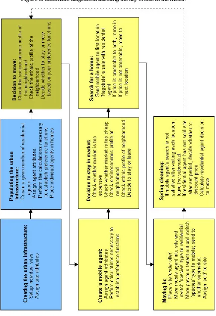
An actual run of the model is organized as a series of events. Many sub-events within the model (such as calculations and the derivation of preference functions) occur on a parallel basis, but the main events in the model—setup and the initiation of model parameters, simulating the location process, and the updating of model parameters— occur iteratively (figure 5).
The first event in the model is the creation of a realistic urban infrastructure. The ‘god’ agent is called upon to determine the location of individual sites in the model and to assign various infrastructure attributes to those sites. Following this, the model is ‘populated’ with residential agents. In this stage, ‘residential’ software agents are assigned to simulated property sites, to serve as in situ owner-occupiers. Once again, the ‘god’ agent is used to automate much of this. A given number of residential agents are created with blank profiles. Life-like attributes are then assigned to those agents and the calculations necessary to establish their preference functions are performed. Agents are then placed in individual homes. At this stage in the model run, the ‘seed’ conditions for an iteration of the model have been established; the setup phase of the model has been completed, and the model moves into simulating the residential location process.
Before we introduce mobile agents into the simulation environment we must determine whether any of the residential agents would like to put their properties on the market. Some computations are performed and residential agents make a decision whether to move, based on their own conditions and their knowledge of the neighborhood in which they reside. If an agent decides to put its home on the market, the characteristics of the site variable for that particular location are updated to reflect that.
it has entered is suitable, before evaluating individual sites. The mobile agent checks whether the market is too expensive for its budget, or alternatively whether it is too far below (50% of) its value platform. Then the agent scans the socioeconomic and ethnic profiles of the residential agents already residing in the submarket, and based on its biases will decide whether to stay in the submarket and evaluate sites, or move on to another submarket elsewhere.
If the agent decides to stay, it begins to search for a home. The agent moves within the model space and visits the first location for sale. Once there, it ‘negotiates’ a sale with the residential agent. If the price of the property is amenable to both agents (and the characteristics of the property match the preferences of the mobile agent), the mobile agent will ‘move-in’, otherwise it will visit the next available property. If after visiting all available properties in the model, the agent has not found a home, it leaves the particular submarket and begins its search elsewhere. However, if the agent decides to buy or rent a particular property, the property is put ‘under offer’. The mobile agent and the residential agent trade ‘species’ tags (the mobile agent becomes residential and vice-versa); the residential agent is moved out of the submarket and the mobile agent moves into the property; and a ‘sold’ tag is assigned to that particular site.
The final stage in an iteration of the model is a round of ‘spring-cleaning’. Dissatisfied mobile agents are sent to alternative submarkets and if a residential agent has not managed to sell its property it decides whether to discount the price of the real estate in subsequent iterations of the model. Currently, prices are discounted by 5% after four iterations of the model. The model then returns recursively to decide whether residential agents are going to move.
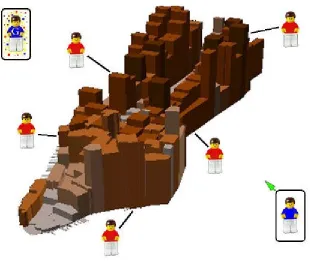
6.4. Graphic user interface
buttons and sliders are available to run particular events in the model and to vary the value of parameters that are used in model calculations, ‘on-the-fly’. A main graphics window is also shown, providing information on the position of sites and agents within the model space at any given moment. Additionally, symbols in the graphics window can be programmed to alter shape and color depending on the conditions of the attributes that they represent (in figure 6 they are colored to represent the ‘ethnicity’ of the agents residing in those sites). The graphics window, and the artificial submarket that it represents, are designed to mimic how a residential submarket would appear in the real world (figure 7). Residential agents are situated within particular sites. Upon visiting the submarket, a mobile agent will travel to these sites and evaluate their suitability for its purposes. Additionally, we have a ‘god’ agent (denoted in the diagram with the letter ‘G’) that is active in automating tasks within the simulation, but does not partake in the residential location process.
7. Future developments
Figure 7. The graphic user interface to the residential location model.
The current application of the model to a handful of sites in one particular submarket is, of course, quite simplistic. Linking several independent submarkets and facilitating the exchange of agents between them will take some further work. However, this should allow certain hypotheses about the residential location process (the dynamics of gentrification and neighborhood decline, the factors driving residential segregation, etc.) to be explored in an abstract fashion. Connecting the residential micro-model with other related micro-components such as industrial location and development modules is another task that we need to accomplish. Additionally, there is much work to be done in designing interfaces (data exchanges, constraints) with meso- and macro-scale models, as well as the design of feedback mechanisms between independent model components.
8. Conclusions
The discussion thus far has been quite optimistic about the potential of geocomputation techniques to revitalize operational simulation. The techniques themselves do certainly represent the possibility for a ‘revolution’ in the way we simulate urban systems. However, there are some imposing barriers to putting those techniques into practical use in the real world (Torrens & O’Sullivan, 2001). Ironically, computing power poses one of the most pressing limitations. The prototype that we have developed here works quite well and is efficient computationally. However, scaling that model up to represent an entire metropolitan area would require daunting levels of computing power. The only operational equivalent is the TRANSIMS model at Los Alamos National Laboratories, which relies on distributed computing clusters (Nagel, Beckman, Barrett, 1999).
Working at the micro-scale, in some cases, reveals inadequacies in the theory of how cities work. The micro-approach betrays some theoretical gaps in our understanding of the dynamics interactions that shape our urban systems. Indeed, there is some justification for a ‘new urban geography’ of the micro-scale.
Furthermore, micro-scale models, particularly dynamic and process-driven simulations, are quite difficult to calibrate, even if data are available. In CA research, there are some techniques for validating the patterns that those models generate and or matching them with real world conditions. However, process-based calibration techniques are not widely available (Torrens & O'Sullivan, 2001). Organizing the model as a hybrid allows the possibility of scaling up the simulation to meso-scales for validation purposes. This is a reasonable solution, but ideally micro-models would be calibrated at the scale of the entity or the individual. The likely effort required to do this is, however, a daunting prospect.
References
Allen, P M, 1997, Cities and Regions as Self-Organizing Systems: Models of Complexity, (Gordon and Breach Science Publishers, Amsterdam).
Batty, M, 1979, "Progress, success, and failure in urban modeling", Environment and Planning A11 863-878.
Batty, M, Couclelis, H, Eichen, M, 1997, "Special issue: urban systems as cellular automata", Environment and Planning B24.
Batty, M & Longley, P,1994, Fractal Cities, (Academic Press, London).
Ben-Akiva, M & Bowman, J L, 1998, "Integration of an activity-based model system and a residential location model", Urban Studies35 1131.
Benenson, I, 1998, "Multi-agent simulations of residential dynamics in the city", Computers, Environment and Urban Systems22 25-42.
Benenson, I, 1999, "Modelling population dynamics in the city: from a regional to a multi-agent approach", Discrete Dynamics in Nature and Society3 149-170. Bonabeau, E, Dorigo, M, Theraulaz, G, 1999, Swarm Intelligence: From Natural to
Artificial Systems, (Oxford University Press, New York).
Box, P, 2001, "Spatial Units as Agents: Making the Landscape an Equal Player in Agent-Based Simulations", in Integrating Geographic Information Systems and Agent-Based Modeling Techniques for Simulating Social and Ecological Processes, Ed. H R Gimblett (Oxford University Press, Oxford). http://www.nr.usu.edu/swarm/.
Carter, H, 1981, The Study of Urban Geography, (Edward Arnold, Victoria, Australia).
Centre for Computational Geography GeoTools, Leeds. University of Leeds, School of Geography. http://www.ccg.leeds.ac.uk/geotools/
Couclelis, H, 1997, "From cellular automata to urban models: New principles for model development and implementation", Environment and Planning B 24 165-174.
De la Barra, T,1989, Integrated Land Use and Transport Modelling: Decision Chains and Hierarchies, (Cambridge University Press, Cambridge).
Dijkstra, J, Timmermans, H J P, Jessurun, A J, 2000, "A multi-agent cellular automata system for visualising simulated pedestrian activity", in Theoretical and Practical Issues on Cellular Automata, Ed. S Bandini, T Worsch (Springer-Verlag, London),29-36.
Ferber, J, 1999, Multi-Agent Systems: An Introduction to Distributed Artificial Intelligence, (Addison-Wesley, Harlow (UK)).
Fotheringham, A S & O'Kelly, M E, 1989, Spatial Interaction Models: Formulations and Applications, (Kluwer Academic Publishers, Dordrecht).
Hall, P, 1983, "Decentralization without end?", in The Expanding City: Essays in Honor of Professor Jean Gottmann (Academic Press, London).
Harris, B, 1994, "The real issues concerning Lee's "Requiem"", Journal of the American Planning Association60 31-34.
Holland, J H, 1998, Emergence: From Chaos to Order, (Perseus Books, Reading, MA).
Isard, W, 1975, Introduction to Regional Science, (Prentice-Hall, Englewood Cliffs, New Jersey).
Krugman, P,1996, The Self-Organizing Economy, (Blackwell, Malden, MA).
Kurzweil, R, 1999, The Age of Spiritual Machines: How We Will Live, Work and Think in the New Age of Intelligent Machines, (Phoenix, London).
Lee, D B, 1973, "Requiem for large-scale models", Journal of the American Institute of Planners39 163-178.
Lee, D B, 1994, "Retrospective on large-scale urban models", Journal of the American Planning Association60 35-40.
Leonard, A,1997, Bots: The Origin of a New Species, (Hardwired, San Francisco). Levy, S, 1992, Artificial Life: The Quest for a New Creation, (Penguin Books,
London).
Longley, P A & Harris, R J, 1999, "Towards a new digital data infrastructure for urban analysis and modelling", Environment and Planning B26 855-878.
Luna, F & Stefansson, B, Eds, 2000, Economic Simulation in Swarm: Agent-based Modelling and Object Oriented Programming (Kluwer, Dordrecht).
Mitchell, M, 1998, An Introduction to Genetic Algorithms, (MIT Press, Cambridge, MA).
Nagel, K, Beckman, R J, Barrett, C L, 1999, "TRANSIMS for urban planning", LA-UR 98-4389, Los Alamos National Laboratory, Los Alamos, NM.
http://transims.tsasa.lanl.gov/.
Nagel, K, Rasmussen, S, Barrett, C L, 1996, "Network traffic as self-organized critical phenomena", TSA-DO/SA MS-M997 and CNLS MS-B258, Los Alamos National Laboratory, Los Alamos, NM. http://transims.tsasa.lanl.gov/.
Noth, M, Borning, A, Waddell, P, 2000, "An extensible, modular architecture for simulating urban development, transportation, and environmental impacts", UW CSE Technical Report 2000-12-01, University of Washington, Department of Computer Science and Engineering, Seattle. http://www.urbansim.org.
Openshaw, S,1983, The Modifiable Areal Unit Problem, (GeoBooks, Norwich). O'Sullivan, D & Torrens, P M, 2000, "Cellular models of urban systems", in
Portugali, J, Benenson, I, Omer, I, 1997, "Spatial cognitive dissonance and sociospatial emergence in a self-organizing city", Environment and Planning B 24 263-285.
Preece, J, 1994, Human-Computer Interaction, (Addison-Wesley Publishing, Harlow, England).
Sayer, R A, 1979, "Understanding urban models versus understanding cities", Environment and Planning A11 853-862.
Schelhorn, T, O'Sullivan, D, Haklay, M, et al., 1999, "STREETS: an agent-based pedestrian model", CASA Working Paper 9, University College London, Centre for Advanced Spatial Analysis, London.
Schelling, T C, 1969, "Models of segregation", American Economic Review 59 488-493.
Schelling, T C,1978, Micromotives and Macrobehavior, (WW Norton and Company, New York).
Sipper, M, 1997, Evolution of Parallel Cellular Machines: The Cellular Programming Approach, (Springer, Berlin).
Torrens, P M, 2000a, "How cellular models of urban systems work", CASA Working Paper 28, University College London, Centre for Advanced Spatial Analysis. http://www.casa.ucl.ac.uk/working_papers.htm.
Torrens, P M, 2000b, "How Land-Use and Transportation Models Work", CASA Working Paper 20, University College London, Centre for Advanced Spatial Analysis (CASA). http://www.casa.ucl.ac.uk/working_papers.htm.
Torrens, P M & O'Sullivan, D, 2001,"Cellular automata and urban simulation: where do we go from here?", Environment and Planning B28 163-168.
Waddell, P A, 2000a, "A behavioural simulation model for metropolitan policy analysis and planning: residential location and housing market components of UrbanSim", Environment and Planning B27 167-324.
Waddell, P A, 2000b, "Towards a Behavioral Integration of Land Use and Transportation Modeling", in The 9th International Association for Travel Behavior Research Conference, Queensland, Australia. http://www.urbansim.org/Papers/.
White, R & Engelen, G, 1997, "Cellular automata as the basis of integrated dynamic regional modelling", Environment and Planning B24 235-246.
White, R & Engelen, G, 2000, "High-resolution integrated modelling of the spatial dynamics of urban and regional systems", Computers, Environment and Urban Systems24 383-400.