CHAPTER SEVEN
THE SPATIAL PROCESS OF CREATING PLACES OUT OF NODESIN RAILWAY TERMINUS AREAS
This thesis has investigated a fundamental issue for the design process of railway
terminus areas; which spatial conditions lead to high levels of mixed-use and activity
within railway termini. Conceptually it seeks a spatial model of railway terminus
areas that allows the terminus buildings, as transport nodes, to work also as
significant places in the city.
It has been suggested that planners and designers still perceive railway station area
redevelopment as a daunting task that requires complex and long term management
procedures and a fusion of disciplines. Despite Bertolini and Spit’s (1998) clear
conclusion that the key concept in most current projects was to develop railway
stations as a node and place in the city, the missing link between spatial design and
its effects on space uses has created an ambiguous and vague task for architects and
urban designers. This thesis has employed a combination of configurational analyses
of increasing precision, urban condition surveys, and detailed observations to
examine London's eleven mainline railway terminus areas. So far, it has revealed that
it is possible to analyze the relationship between morphological patterns and space
uses within the areas.
At the end of each chapter, the main findings have been discussed in detail. This
final chapter brings all these conclusions together into a single conceptual framework
of the ‘node-place’. It is structured into three parts. Beginning with the crucial
examination of the effects of urban spatial configuration on space uses within all
London's termini, the first part presents the regression analyses between the
quantification of the stations' spatial embedding1 and percentages of non-passenger
spaces, including retail/catering functions, within the termini (differentiated from
passenger and transport-related functions)2. With a set of precise spatial and space
use data, this final analysis aims to justify the main hypothesis that the degree of
mix-use space within the environment, a characteristic of a vibrant urban place, is
critically related to how each station concourse is embedded within their urban
1 The spatial embedding values of all London's railway termini are derived from the spatial analysis in Section 5.3.3 of Chapter Five.
settings, each with distinctive spatial structures. In the second part of this chapter,
each of London's railway termini will be reviewed in the light of their node and place
characteristics, and further consideration will be given to their development
potential based on the outcomes of the whole research. The final epilogue concludes
by suggesting a theoretical model in which a railway terminus can be transformed
from a node into a place.
7.1 REGRESSION ANALYSIS:
The relationship between spatial embedding values
and non-transport related space uses of the railway terminus buildings
It has been suggested in the preceding chapter that the integrated spatial grid
networks of sub-areas around some of London's termini such as Liverpool Street,
Fenchurch Street, Victoria, Charing Cross, and Cannon Street Stations, sustain high
levels of natural movement because their external structures cause very little
interruption to the spatial context. However, the spatial embedding analysis in
chapter five (section 5.3.3) revealed that only Liverpool Street Station appears to
have its internal space well embedded in the local and global spatial grid structures.
The station outperforms the others by improving to a greater extent the local and
global integration including the intelligibility values of its urban setting.
Based on Hillier's ideas of natural movement and the movement economy, the main
proposition for successfully creating a place out of a transport node such as a railway
terminus is to embed its internal space into the local grid network so that the node
itself becomes an integrated part of the local pedestrian movement system.
Practically, this means creating 'urban grid related movement' to complement the
deterministic 'station related movement' inside the terminus building. This is
similar to the principle of how the spatially integrated sub-areas around some
terminus structures sustain good levels of natural movement to complement the
deterministic movement attracted and generated by the station entrances (as
discussed in chapter six). The conjecture is that the level of urban dwellers
naturally drawn into any given railway terminus building is dependent on the degree
to which its internal space is embedded within the urban spatial structure. These
'other station users', categorised as 'non-passengers' as opposed to 'passengers'
entering the stations to board trains or other transport modes, belong to the local
movement system of the terminus area and their levels are largely determined by the
Through the movement economy process, the successful development of
movement-seeking functions such as retail and catering facilities is thus more likely to occur
within station concourses that are used to a greater extent by the non-passengers
whose numbers are not affected by the train timetable but remain constant throughout
the day. The ratio of these urban facilities to all public accessible areas inside the
termini can then also be examined in relation to the spatial embedding values of the
termini, addressing the likely profit-making considerations faced by station
operators. Transport nodes such as railway termini, whose internal spaces have a
good degree of mix among not only station users - both passengers and
non-passengers – but also mixed types of activity - both transport and non-transport
related facilities - then become vibrant urban places in their own right. This
conjecture will be justified by the strong relationship between the ratios of
non-passenger and retail/catering spaces recorded within the terminus buildings and
their spatial embedding values.
The final regression analyses are based on the spatial embedding variables derived
from section 5.3.3 of chapter five and the space use data supplied by the station
operators3. Table 7.1 illustrates all variables for all London's eleven termini in the
form of a single data table. Columns A and B list global and local spatial embedding
values respectively4. In order also to examine if the non-transport related internal
space uses are influenced by the degree to which the terminus spaces enhance the
intelligibility of their urban surroundings, column C (the ratio of the intelligibility
value of the area with and without the terminus space5
)
is also included in thestatistical analyses.
Columns D-L list the internal space use data of all London's termini including the
related calculations. The two key dependent variables that will be examined
separately in relation to the three independent spatial variables mentioned above
(columns A-C) are shown in column E (percentage of non-passenger) and column L
(percentage of retail and catering spaces inside the termini).
3 The internal space use data for Charing Cross, Liverpool Street, Victoria, Euston, Waterloo, London Bridge,
Paddington, and King's Cross Stations was provided by Railtrack (currently dissolved). The data for Fenchurch Street
and Marylebone Stations was provided by C2C Railways and Chiltern Railways respectively. The data for Cannon Street
Station is from London Bridge Station's operator who presently operates both stations.
4 Refer to section 5.3.3. The global spatial embedding value of the terminus space is the ratio between mean global integration value of the station's modeling area with the terminus space and that without (µ.intN.w.intl//wo.intl) while the local spatial embedding value of the terminus space, the ratio between mean local integration value of the station's
modeling area with the terminus space and that without (µ.int3.w.intl//wo.intl)..
Table 7.1: Spatial embedding values and internal pedestrian space use data for London's railway termini
column A B C
µ.intN.w.intl µ.int3.w.intl intllgblty.w.intl //wo.intl //wo.intl wo.intl
Cannon Street 1.0006 0.9987 0.9976
Charing Cross 1.0009 1.0007 0.9994
Liverpool Street 1.0304 1.0121 1.0767
Victoria 1.002 1.0006 1.0036
Fenchurch Street 0.9812 0.9883 0.9862
Euston 1.0019 0.9996 1.0018
Marylebone 1.0004 0.999 1.0024
Waterloo 1.0007 0.9987 1.0004
London bridge 1.003 1.0002 1.0037
Paddington 1 0.9985 1.0021
King's Cross 1.0017 0.9997 0.988
column D E F G H I J K L
% of % of internal internal total internal % of % of % of passenger non-passenger retail area catering area total F+G public area internal internal J+K areas
(sq.m.) (sq.m.) (sq.m.) (sq.m.) retail area catering area
Cannon Street 90 10 388 255 643 1890 20.5 13.5 34
Charing Cross 80 20 481 563 1044 2486 19.3 22.6 41.9
Liverpool Street 60 40 2310 2103 4413 9006 25.6 23.4 49
Victoria 82 18 1830 1404 3234 7099 25.8 19.8 45.6
Fenchurch Street n/a n/a 68 87 155 890 7.6 9.8 17.4
Euston 82 18 604 1212 1816 5310 11.4 22.8 34.2
Marylebone 88 12 195 225 420 1250 15.6 18 33.6
Waterloo 87 13 812 1550 2362 5905 13.8 26.2 40
London bridge 88 12 738 540 1278 3203 23.1 16.8 39.9
Paddington 91 9 415 1053 1468 4503 9.2 23.4 32.6
King's Cross 86 14 308 729 1037 2921 10.5 25 35.5
The stepwise regression analyses shown in Tables 7.2-7.3 reveal that the local
spatial embedding values (column B in Table 7.1 ) generally outperform the other two
spatial variables. This means the number of non-passengers and the amount of
retail/catering spaces inside the termini are most influenced by how their internal
spaces are embedded within their local grid configuration (integration 3). This is
similar to pedestrian movement levels around the terminus structures which are also
found to be most influenced by how the grids are structured to benefit local-scale
movement in the areas, confirmed by the regression analyses in chapter six6.
Table 7.2: Stepwise regression analysis: percentage of non-passengers inside London's railway termini and spatial embedding variables
PERCENTAGE OF NON-PASSENGER in London's termini vs.3 independent variables
* µ.intN.w.intl//wo.intl * µ.int3.w.intl//wo.intl * intllgblty.w.intl//wo.intl
F to Enter 4 F to Remove 3.996 Number of Steps 1 Variables Entered 1 Variables Forced 0…0
(Last Step) STEP NO.1 VARIABLE ENTERED X1:µ.int3.w.intl//wo.int
Analysis of Variance Table R: .793 R-squared: .629 Adj. R-squared: .576 Std. Error: 2.5
DF: Sum Squares: Mean Square: F-test: 1 74.247 74.247 11.878 7 43.753 6.25
8 118
Source REGRESSION RESIDUAL TOTAL
Variables in Equation
Value: Std. Err.: Std. Value: F to Remove: -3588.477
µ.int3.w.intl//… 3604.199 1045.751 .793 11.878 Parameter:
INTERCEPT
Variables Not in Equation
Parameter: Par. Corr: F to Enter: µ.intN.w.intl//… .367 .935 intllgblty.w.int… .027 .004
Table 7.3: Stepwise regression analysis: percentage of retail and catering spaces inside London's railway termini and spatial embedding variables
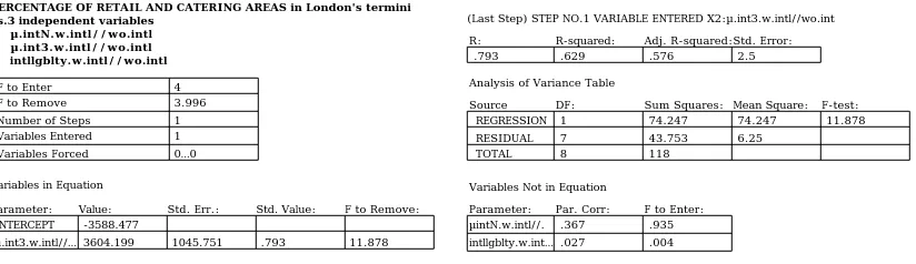
PERCENTAGE OF RETAIL AND CATERING AREAS in London's termini vs.3 independent variables
* µ.intN.w.intl//wo.intl * µ.int3.w.intl//wo.intl * intllgblty.w.intl//wo.intl
F to Enter 4 F to Remove 3.996 Number of Steps 1 Variables Entered 1 Variables Forced 0…0
Variables in Equation
Value: Std. Err.: Std. Value: F to Remove: -3588.477
µ.int3.w.intl//… 3604.199 1045.751 .793 11.878 Parameter:
INTERCEPT
Variables Not in Equation
Parameter: Par. Corr: F to Enter:
intllgblty.w.int…
.367 .935 Analysis of Variance Table
DF: Sum Squares: Mean Square: F-test: 1 74.247 74.247 11.878 7 43.753 6.25
8 118
Source REGRESSION RESIDUAL TOTAL
(Last Step) STEP NO.1 VARIABLE ENTERED X2:µ.int3.w.intl//wo.int R: .793 R-squared: .629 Adj. R-squared: .576 Std. Error: 2.5 µintN.w.intl//. .027 .004
Plate 7.1a shows the simple regression analysis between local spatial embedding
values (column B in Table 7.1) and the percentage of non-passengers inside all
London's termini excluding Fenchurch Street Station 7 (column E in Table 7.1 ). The
scattergram reveals a strong correlation, with an R-squared value of 0.922. However,
the scatters are not evenly distributed along the regression line due to a large margin
between Liverpool Street Station, positioned at the top right corner, and the other
termini, grouped in the bottom left. This is because Liverpool Street Station
significantly outperforms the other termini in terms of its degree of spatial
embedding as well as the percentage of non-passengers the terminus draws into its
internal space. The simple regression analysis (Plate 7.1b ) with Liverpool Street
Station excluded in order to reveal a truer picture of the relationship between both
variables in all other stations, still gives a striking result. The scattergram shows a
strong correlation with an R-squared value of 0.629.
Plate 7.1: Regression analysis: percentage of non-passenger inside London's railway termini and their local spatial embedding values
5
.998 1 1.002 1.004 1.006 1.008 1.01 1.012 1.014 µ.int3.w.intl//wo.intl
y = 2126.459x - 2111.517, R-squared: .922 %non.passenger 10 15 20 25 30 35 40 45
.9982.9985.9987 .999 .9992.9995.9997 1 1.0003 1.0005 1.0008 µ.int3.w.intl//wo.intl
y = 3604.199x - 3588.477, R-squared: .629 %non.passenger 8 10 12 14 16 18 20 22
a: all termini b: all termini except Liverpool Street Station
LIV PAD CAN MAR WAT EUS KX LON VIC CHX
all the other termini
The simple regression analysis, depicted in Plate 7.2a-b , between local spatial
embedding values (column B in Table 7.1 ) and percentage of retail/catering spaces
7
According to the interview with the station manager of C2C Railways, the operator of Fenchurch Street Station, C2C has no record of demographic data on percentages of passenger and non-passenger. It might be possible that the number of non-passenger is very low because this small and elevated station is rather segregated from the street level.
within all eleven termini (column L in Table 7.1 ) shows a rather similar pattern. In
the first scattergram, two large margins are caused by Fenchurch Street and
Liverpool Street Stations which are apparently isolated from the rest of the group.
While Liverpool Street Station, positioned at the top right corner, apparently greatly
outperforms the others, Fenchurch Street Station is contrarily the worst in the group,
located to the bottom left. However, the exclusion of these two exceptional cases in
the next scattergram (Plate 7.2b ) still reveals a strong correlation with an R-squared
value of 0.557.
Plate 7.2: Regression analysis: percentage of retail and catering spaces inside the railway termini and local spatial embedding values
1 µ.int3.w.intl//wo.intl
y = 3988.142x - 3948.758, R-squared: .557
%retails+catering
.9982 .9985 .9987 .999 .9992 .9995 .9997 1.0003 1.0005 1.0008 32 34 36 38 40 42 44 46 1 µ.int3.w.intl//wo.intl
y = 1360.398x - 1323.216, R-squared: .774
15 20 25 30 35 40 45 50 %retails+catering
.9875 .99 .9925 .995 .9975 1.002 1.005 1.008 1.01 1.013 1.015
a: all termini b: all termini except Liverpool Street
and Fenchurch Street Stations
LIV FEN VIC CHX LON WAT KX EUS CAN MAR PAD all the other termini
The results are striking. Both simple regression analyses confirm that the more the
terminus building spatially embeds within its local grid structure, the more it
attracts non-passenger users and influences the development of retail and catering
spaces within its internal space.
The terminus building that makes its urban setting more locally integrated within the
city, demonstrated by an increase in mean local integration values for the area after
its internal space is included, makes the terminus area more accessible for local
scale journeys. Its internal space, which becomes an integrated part of those
journeys, is thus likely to be used by more urban dwellers and subsequently attract
more retail and catering spaces that would take advantage of their through movement.
The station where various types of people and activity, both transport and
non-transport related, converge throughout different times of the day would never be left
entirely vacant even during the station's off-peak periods due to the continuous flow
of natural movement sustained by the urban grid configuration itself.
Through a set of precise spatial and space use data, the statistical analyses verify
that the process of creating a place out of a transport node such as a railway terminus
is critically related to spatial variables. It also establishes the crucial fact that the
degrees of mixed station users and activities in its internal environment, has to act as
a 'configurational attractor'.
Liverpool Street Station, the only successful case, reveals that to enable this to
happen, the station's surrounding grids have to be well interconnected and integrated
within the larger urban spatial network. Its annexed urban redevelopment not only
eliminates the spatial incision caused by the railway lines but also utilises its
spatial potential by drawing several important integrators into both the site and the
newly refurbished terminus building. A major transport node and 'point attractor'
such as Liverpool Street Station, whose urban spatial structure allows its internal
space to become a 'configurational attractor', thus becomes a vibrant urban place in
its own right.
7.2
LONDON'S MAINLINE RAILWAY TERMINUS AREAS:A review of their node and place characteristics and development potential
It appears that the outstanding success of Liverpool Street Station cannot be easily
imitated elsewhere due to its unique spatial layout and relationship to the city. The
distinctive urban spatial configurations of London's railway terminus areas, caused by
the initial layouts of the terminus structures in different locations and a long process
of the areas' evolution8, make all the termini idiosyncratic nodes and places in the
city. Not all of them appear to achieve, or have a development potential to achieve, the
ideal node-place synergy in railway terminus areas, as discussed in chapter two
(section 2.2). The diagrammatic framework, shown again here in Plate 7.3 , envisages
the final stage of a successfully evolving railway terminus area. It depicts the ideal
circumstance whereby the terminus, as a major node of the transport network, has been
transformed into a place and the formerly blighted immediate surroundings have also
been revitalised as a vibrant urban setting. The successful redevelopment outcome is
thus projected as a node-place railway terminus well embedded within its urban place
setting in which a cluster of mix-use activities is found in and around the station
building. The whole complex acts as a catalyst for further urban development which
might lead to the station area becoming a rejuvenated local centre.
8 Refer to Section 4.1: Development of London's mainline railway termini and Section 4.2: The changing morphology
place
node place potential centrality
RAILWAY TERMINUS immediate surroundings further surroundings
approach railway lines
blighted area urban area
transport infrastructures
Plate 7.3: The ideal model of node-place synergy in railway terminus area, further developed from the original Bertolini and Spit's model.
Based on the outcomes of the whole research, the following review will discuss the
potential for each of London's terminus areas in the light of this conceptual framework,
showing how and why some nodes are more successful as places and possess more
potential than others to be further developed as live centres, as defined by Hillier
(2000).
* Liverpool Street Station appears to be the only London terminus which is likely to
achieve the ideal node-place synergistic model mentioned above. Having an important
integrator extending all the way through its lower-level concourse hall from Eldon
Street with another two integrators running across both of its upper-level promenades,
its internal space becomes very well integrated in the spatial grid structure. The
station has far better spatial embedding values, both locally and globally, than the
other termini. It becomes, therefore, an important part of both local and global
movement systems that pedestrians naturally use as a part of their journeys within the
area. The station also improves the mean intelligibility value of its urban setting.
This suggests that its existence enhances the navigational knowledge of pedestrians in
the area, or expressed more formally, the quality off information about how the whole
(global) area is structured that people derive when moving around locally.
High levels of non-transport related use and activity are found to be influenced by this
and records 49% of retail and catering spaces9, almost half the number of all station
users and half the amount of all public accessible spaces of the station concourse.
The dense and coherent grid-integration network of the station area greatly contributes
to the success of the terminus as it provides the spatial potential for its concourse
space to draw integration into itself. It thus seems that the station building and its
surrounding spatial structures become unified as a single integrated grid network.
This development potential of Liverpool Street Station provided by its spatial setting
became tangible after the completion of the Broadgate Complex development which
started prior to the refurbishment of the station itself. Using the air rights above the
railway structures, the new development complex not only eliminates the urban
incision formerly caused by the old Broad Street Station and the approach railway
lines, but also draws integration into the site itself. In other words, the complex
utilises the spatial potential of the larger urban network to integrate itself more fully
within the city. The neighbourhoods on both sides of the railway tracks become
reconnected by several integrators through the newly developed complex of mix
business, retail and commercial land uses, including three new public squares. It also
provides accessibility to the station's concourse space in all directions. High levels of
movement, attracted by the station entrances and sustained by the integrated grid
configuration, are evidenced in all sub-areas around the terminus. As a
configurational attractor, the terminus which is knotted by transport networks has
thus also become a node within the pedestrian network.
The initial development of the Broadgate Complex in the 1980s has been followed by
several more phases, filling the building blocks and usable grounds into the vacant
areas mostly located to its north along the railway lines. Other urban development
projects of varied scales are also evident within the immediate surroundings of the
complex especially to its east side around the Spitalfields area and its northwest
around Shoreditch. The station area now accommodates both old and new land uses of
mixed activity ranging from quiet residential, light industrial, warehouses and
workshops to busy retail, commercial and business uses. Only the areas located
alongside the railway tracks further down the lines are still left undeveloped and
slightly blighted. However, it is clearly evident in the current figure and ground
study of the station area that its figural block pattern becomes denser and more
coherent as the urban grid network around the terminus structures becomes more
intensified due to these fill-in developments.
From the morphological point of view, it thus seems that the Liverpool Street Station
area has great potential to be further developed as a live centre, to use Hillier’s
terminology (2000). From the urban area severely scarred by the entangled railway
structures of Broad Street, Liverpool Street and Bishopgate Stations, its spatial grid
structure has been re-engineered to be more intensified and integrated with the city.
The revival of natural movement into the area along with the add-on station related
movement around the station due to its nature as a great movement attractor has
subsequently influenced and even accelerated the movement economy process,
resulting in a cluster of mixed uses and activity focusing in and around the terminus.
This potential is strengthened by the fact that more and more urban development
projects of mix land use are evident around the station's core complex which is
constantly fluxed by both station-related and grid-related movements.
Plate 7.4 summarises the Liverpool Street Station area redevelopment strategy in a
conceptual diagram. The terminus can be seen as a node and place well embedded
within its urban place setting whereby a spatial potential to be further developed into
a new local centre is also strongly evident.
Plate 7.4: Diagram of LIVERPOOL STREET STATION AREA redevelopment strategy
undeveloped railway terminus redeveloped railway terminus
potential urban redevelopment station related urban redevelopment
urban area
urban area with blighted condition KEY PLAN
* Victoria Station is an enclosed node located within a mixed vibrant and quiet
setting. Although its recently refurbished terminus building is located within a dense
and integrated grid network and has several entrances situated in almost all
directions, the internal space does not utilise the spatial potential provided by its
urban setting to draw any significant integrator into itself. As a result, the terminus
is not very well embedded spatially and even becomes a barrier to some of its
surrounding grids. The concourse space attracts only 18% non-passengers, which is
not proportionate with a rather high percentage of retail and catering spaces (45.6%).
refurbishment plan of the station operator. Its detailed internal study10 revealed that
the number of station users in Victoria Station would dramatically decrease during its
off-peak periods such as the late morning and the late afternoon.
However, among all the other London's railway termini besides Liverpool Street Station,
Victoria Station seems to be the next best terminus with a great potential to be further
developed and achieve the ideal node-place synergy. This is because its surrounding
grid network is already dense and well integrated. The approach railway lines are well
embedded within the urban grid structure and the station area in general is not limited
nor confined by any other natural or man-made barriers. Its grid network is densely
constituted with coherent and regular figural building blocks, almost reflecting the
fine mesh of its urban spatial pattern. Sub-areas at the station's front attract high
levels of both grid-related and station-related movement while those at the rear which
sustain only moderate levels of natural movement are still well fluxed with movement
attracted and generated by the station entrances.
The negative attractor effects in the area are limited as the terminus structures allow
most of the grids to cross over. Based on these morphological properties of the site
alone, there are two major suggestions to enhance Victoria Station as a vibrant urban
place. First, certain station entrances should be relocated in order to align with major
integrators which would then pass through its internal space. This would eliminate its
nature as a spatial barrier and instead re-integrate the terminus into the local
movement system. Second, the station's annexed development complex (Victoria
Shopping Arcade) should be expanded to cross all the way over the railway tracks so
that it can reconnect both neighbourhoods alongside the railway embankment.
Apart from the ongoing commercial and office developments evidenced around the front
and sides of the terminus building, Victoria Station also has a potential development
area at its rear. The below-ground level railway lines make it technically easier and
more cost effective for any usable space to be built over. If the existing terminus
complex could be spatially reorganised by utilising more of its spatial potential and
further urban development at the station's rear could create integrated links between
both sides of the railway embankment, the station area would also have a potential to be
further developed into a new local centre.
Plate 7.5 summarises the current development strategy of Victoria Station area. The
diagram portrays the terminus and its annexed office and shopping complex as
enclosed and isolated entities. The ongoing development projects mostly located to the
station's front and sides are not related in any way with the station's internal space.
However, the site still accommodates a potential development area at the station's rear.
Plate 7.5: Diagram of VICTORIA STATION AREA redevelopment strategy
undeveloped railway terminus redeveloped railway terminus
potential urban redevelopment station related urban redevelopment
urban area
urban area with blighted condition KEY PLAN
* Euston Station can be seen as a comparative case to Victoria Station. Similar to
Victoria, Euston Station is also an enclosed node located within a mixed vibrant and
quiet urban setting (Plate 7.6 ). Both share similarities in terms of the physical and
spatial characteristics of their terminus as well as surrounding urban structures. The
station buildings are about the same size, with similar ground-level station
concourses, platforms and approach railway lines. Although Euston Station area is
limited by Regent's Park and the King's Cross railway lands to the west and east
respectively and its railway lines act as a more severe urban barrier than those of
Victoria Station, both terminus spaces still share approximately the same value of
global spatial embedding (1.0020 and 1.0019 for Victoria and Euston Stations
respectively11) and attract the same percentage of non-passengers (18%12). These
precise spatial and space use data suggest that both terminus areas are spatially
related to the city in a similar way despite being scarred by two completely different
station structure layouts13.
Although Euston Station appears to fit well within the urban grid pattern14, its
internal space, similar to Victoria, is still rather enclosed and segregated from the
11 Refer to Table 7.1, column A: the ratio of the mean integration values of the station's modeling area with and without the internal space.
12 Refer to Table 7.1, column E: percentage of non-passengers.
13 Refer to Section 3.7: Discussion and conclusion in Chapter Three: The internal dynamic of railway termini, a comparative study of Euston and Victoria Stations.
urban surroundings. The terminus building is set back at the front from Euston Road.
Although one major integrator is drawn into its internal space, it appears to pass
through only the front colonnade not the main concourse hall. Its recently refurbished
terminus space is well used mostly by transport passengers during the station's peak
periods and left almost vacant at other times of the day15.
Unlike Victoria, the spatial structure of Euston Station's rear area, especially to the
west side of the railway embankment, does not have grid-integration but
line-integration characteristic. Although the grid network is still quite densely
distributed, its approach railway lines allow only a few routes to cross over. The
spatial configuration of the areas along the railway lines thus appears to be less
integrated than that of the front. This also reflects in different levels of movement and
types of activity evidenced within the front and the rear areas. While to the station's
front there is a vibrant urban environment of mixed business, commercial, retail,
residential, hospital, and university land uses, the rear is mostly occupied by quiet
and well-kept residential neighbourhoods. However, although low levels of natural
movement are recorded, these residential areas are not in a state of blight. According
to the detailed spatial analysis16, it appears that all sub-areas around Euston Station
are tied together by a major grid framework formed by three important integrators:
Camden High Street, Hampstead Road, and Euston Road. Despite being less integrated,
these rear areas are not segregated as lumps. The current figure and ground study also
confirms that the overall urban physical pattern around the terminus structure is
dense and coherent throughout.
The development potential of Euston Station area is not limited spatially but by the
building height control area called 'the St.Paul's Height'. The regulation prevents any
large scale vertical building development in the area that would block the view of
St.Paul's Cathedral from Primrose Hill. The area is thus still largely undeveloped as
large scale development projects built horizontally are considered less feasible by
developers. The office complex in front of the station, including all other high-rise
buildings in the area, were constructed before the commencement of this regulation.
Although there are also some other small scale retail, business, and residential
developments within the Asian communities located alongside the station building,
they are not related in any way with the terminus space.
15 Refer to Chapter Three.
Plate 7.6: Diagram of EUSTON STATION AREA redevelopment strategy
undeveloped railway terminus redeveloped railway terminus
potential urban redevelopment station related urban redevelopment
urban area
quiet but not blighted urban area KEY PLAN
The suggestion to improve the vibrancy of Euston Station is to create more connections
between the neighbourhoods alongside the railway tracks. This is simply to increase
the spatial potential for the station's internal space to become well embedded within
its urban setting. The station's front entrances should be more directly connected
with Euston Road instead of being hidden behind the bus station and other blockades
in Euston Square Garden and the station's forecourt. The station should also provide
more direct entrances from its rear areas so that the integrators can be drawn in from
all directions.
* Charing Cross, Cannon Street and Fenchurch Street Stations can all be seen as
enclosed nodes on elevated viaduct structures located within vibrant place settings
(Plate 7.6, 7.7, and 7.8 respectively). Although their urban grid structures are
densely interconnected and well integrated, their internal spaces appear to 'float over'
and be segregated from the surroundings. However, despite the topographical limit of
the Thames, Charing Cross and Cannon Street Station areas still outperform Fenchurch
Street Station area as their grid networks appear to be more coherent and densely
intensified. In the latter case, the grids become more sparse in the areas further down
the railway lines as a result of some waste pocket spaces attached to the railway
viaducts themselves. The urban settings of Charing Cross and Cannon Street Stations
thus provide a greater spatial potential for their internal spaces to be embedded.
Additionally, both termini also have a direct access to their concourse halls from the
street level at their front while Fenchurch Street Station is completely elevated above
ground. The two termini are more spatially integrated and record relatively larger
percentages of non-passengers and non-transport related uses than that of the
Fenchurch Street.
In general, these three termini can be seen as being similarly surrounded by vibrant
fluxes of movement adding onto such grid-related movement in some of the sub-areas.
Only Fenchurch Street Station area still has undeveloped sub-areas adjacent to the
railway viaducts further down the lines where low levels of natural movement were
recorded. This is simply because Cannon Street and Charing Cross Stations have a
rather limited rear area where their terminus structures create very little effect upon
the surroundings.
However, their topographical limitation means that Charing Cross and Cannon Street
Station areas have less spatial potential for future urban development compared to
Fenchurch Street Station area. Both terminus areas almost have no room for future grid
intensification that could take advantage of both station-related and grid-related
movements and be further developed into new local centres. Large scale building
developments at Charing Cross and Cannon Street Stations were mostly constructed
using the air-rights above and beneath the terminus structures or limited to some
specific locations where some plots of lands were still available such as the riverfront
area in the case of Cannon Street Station and the east side area of Charing Cross Station.
For Fenchurch Street Station, the developments occurred both above and immediately
around the terminus building with some ongoing projects also evident further along the
railway lines.
The option to move the concourse halls down to the ground level in order to provide
some direct spatial connections with their surrounding grids might be too costly and
technically complicated as it would require reorganising the railway track and
platform systems. Thus, it seems that these three elevated termini might not be able to
completely transform into vibrant places to the same degree as the more successful
Liverpool Street Station. However, their internal spaces could be re-engineered so that
they would be more spatially embedded within their already vibrant urban place
settings. In order to achieve this, Fenchurch Street Station needs a more complicated
spatial rearrangement than the other two as its internal space is completely elevated
above the ground level in all sides. This might be done by creating a 'transitional
concourse space' which can be accessible from its surrounding sub-areas at the ground
level of the terminus. This transitional space could function as the station's foyer
which would provide some better links between the street grids and the elevated
concourse hall. Charing Cross and Cannon Street Stations should provide more direct
accesses and visual connection to their concourse halls especially from the sides and
rear where the level differences are large. Their existing front entrances should be
improved in a way that the station concourses become more open and directly
However, Fenchurch Street Station area appears to have a better development potential
than the other two termini as it has no topographical limit and still includes more
undeveloped plots of lands at its rear, evident as gaps of varied sizes in its current
figure and ground pattern. Some waste pocket spaces located further down the
railway lines including their viaduct spaces provide 'rooms' for the urban grids to be
more intensified around the terminus structures.
Plate 7.7: Diagram of CHARING CROSS STATION AREA redevelopment strategy
undeveloped railway terminus redeveloped railway terminus
potential urban redevelopment station related urban redevelopment
urban area blighted urban area KEY PLAN
Plate 7.8: Diagram of CANNON STREET STATION AREA redevelopment strategy
undeveloped railway terminus redeveloped railway terminus
potential urban redevelopment station related urban redevelopment
urban area blighted urban area KEY PLAN
Plate 7.9: Diagram of FENCHURCH STREET STATION AREA redevelopment strategy
undeveloped railway terminus redeveloped railway terminus
potential urban redevelopment station related urban redevelopment
* London Bridge and Waterloo Stations are both enclosed nodes elevated on viaduct
structures which locate within slightly blighted urban settings (Plate 7.10 and 7.11
respectively). Their bold spatial characteristic is the sparsely grid network that
accommodates several waste pocket spaces as well as other urban barriers besides the
terminus structures themselves. Both terminus spaces, also recently refurbished,
were completely elevated above ground level. The station concourses are connected to
their surrounding streets only through a series of ramps, steps, and underground
tunnels. Thus, they are not embedded well within their spatial settings. However,
London Bridge Station appears to outperform Waterloo as its front ramp acts as a
transition space. Two integrators connect Borough High Street to the front with the
concourse hall through this ramp. On the contrary, no significant integrator can be
directly drawn into Waterloo Station's internal space. However, both termini attract
approximately the same percentage of non-passenger (12% for London Bridge and 13%
for Waterloo) and record very close percentages of retail and catering spaces (39.9%
for London Bridge and 40% for Waterloo). This suggests that their surrounding urban
grids might be distinctively structured despite their general similarities.
Similar to the other three elevated termini (Charing Cross, Cannon Street and
Fenchurch Street Stations), London Bridge and Waterloo Stations appear to 'float over'
the urban grid networks rather than being a part of them. However, the surrounding
grids of the first three termini are more densely interconnected while those of the
latter two are more sparse and less coherent. This is because London Bridge and
Waterloo Stations are entangled by the railway structures both at their front and rear.
Most of their viaduct structures have also been blocked off to accommodate other uses.
Some are attached with waste pocket spaces which consist of fenced parking lots, vacant
fields, or deserted playgrounds. Both station areas are also limited by some enclosed
and segregated properties such as Guy's Hospital (in case of the London Bridge) and the
Southbank area, St.Thomas Hospital, and Lambeth Palace (in case of the Waterloo). The
spatial grids around both terminus structures thus appear to be sparsely built up.
Their figure and ground studies also reveal loose and less coherent figural blocks
constituted around large gaps scarred by the railway lines.
As both termini appear to have their entrances rather hidden from the main front
roads, movement recorded within their front areas are largely influenced by other
major attractors. Their sub-areas record high to moderate levels of natural movement
in general. In some sub-areas especially those along the rear side railway lines, low
natural movement rates are recorded and the negative attractor's effects are evident.
pocket spaces or enclosed properties. They have a slightly blighted condition. Some
locations include deserted building structures in a state of disrepair.
Despite several spatial similarities, London Bridge Station area still has a better
development potential than Waterloo Station area. This is simply because the first
area is less limited by enclosed properties than the latter. London Bridge Station area
has more available spaces for future urban development. However, both areas
accommodate several vacant plots of land which have been left deserted or fenced off as
waste areas. These areas provide a great development potential to create a more
intensified grid network around the terminus structures. However, the ongoing urban
developments at London Bridge instead focus intensively along the riverside. Those at
Waterloo Station area include a large scale urban redevelopment at the Southbank and
some smaller projects located to the station's front beyond the railway lines as well as
to the east side. These developments create a more intensified grid pattern around the
terminus building. The Southbank's urban redevelopment at Waterloo Station area
proposes to bring its elevated pedestrian network down to ground level to be able to
make more sensible connections with the surrounding grids. However, all
developments do not appear to create any spatial link with the terminus spaces.
Plate 7.10: Diagram of LONDON BRIDGE STATION AREA redevelopment strategy
undeveloped railway terminus redeveloped railway terminus
potential urban redevelopment station related urban redevelopment
urban area blighted urban area KEY PLAN
Plate 7.11: Diagram of WATERLOO STATION AREA redevelopment strategy
undeveloped railway terminus redeveloped railway terminus
potential urban redevelopment station related urban redevelopment
urban area blighted urban area KEY PLAN
However, the new development plans for both termini suggest that some large scale
office, hotel, and commercial complexes are to be built on top of the station buildings
spaces. The proposals are to move the concourse halls of both termini, now elevated
above ground level, down to the street level in order to extend the length of the rail
platforms all the way into the existing halls. If such proposals were realised, it seems
likely that both London Bridge and Waterloo Stations would become more integrated
within their surrounding grids. They could also be transformed into vibrant urban
places if their spatial potential was fully utilised in the same way as at Liverpool
Street Station.
* Paddington Station is an enclosed node located within a blighted urban setting
(Plate 7.12 ). Although the station has been recently refurbished and now
accommodates more retail and catering spaces including the new airport check-in
facilities, only 9% of the station users are non-passengers. This means that most
people come to use the station for transport purposes. The spatial embedding values
reveal that the terminus space is not very well embedded in its spatial setting. This is
due to the fact that the station is rather enclosed and hidden behind the railway hotel.
As a lower level terminus, the significant level difference of four metres between the
concourse hall and the surrounding streets also makes their spatial connections overly
complicated.
The spatial segregation of the station's internal space is also a result of the disrupted
urban grid structure. In other words, the station site does not provide the spatial
potential for the terminus space to become fully embedded. The grid network of
Paddington Station area is severely disrupted not only by the railway structures and
railway lands but also the Canal Basin and the Westway, all located to the north of the
terminus. Its physical and spatial patterns show a large gap representing the urban
incision caused by these barriers. The negative attractor effects are clearly evident
within their immediate surroundings. Although the station area in general still
records moderate levels of natural movement, the railway lands site is totally deserted
of pedestrian.
However, the ongoing Paddington Basin development does not utilise well the spatial
potential of the site. The spatial analysis of its proposed development plan revealed
that the new complex is segregated as a whole from its surroundings. It does not draw
enough integration into the site to be able to establish itself as an embedded part of the
existing grid network. Due to the level difference between the development complex
and the terminus space, both entities have complicated spatial connections through
ramps and steps. Its future figure and ground pattern also reveals that the new
formerly caused by urban barriers. It also does not create a coherent figural pattern
with the surrounding area.
Being a below ground level terminus like Liverpool Street Station, a multi-layered
environment should be introduced in its internal spatial arrangement. The street level
gallery crossing over the lower level station concourse space could be created as a
direct link between the Paddington Basin development complex, to the north and east of
the terminus, and the west side neighbourhood. This proposal would embed the
terminus space into its setting as well as drawing integration to the station complex
from the station side. As the Westway is a strong barrier and difficult to break
through, the development complex should consider drawing more integration from its
east and south neighbourhoods including creating more connections across the Canal
Basin.
Plate 7.12: Diagram of PADDINGTON STATION AREA redevelopment strategy
undeveloped railway terminus redeveloped railway terminus
potential urban redevelopment station related urban redevelopment
urban area blighted urban area KEY PLAN
* Similar to Paddington, Marylebone Station is a node located in a blighted urban
setting (Plate 7.13 ). The station is set back from the busy Marylebone Road in a quiet
neighbourhood of office, hotel, and residential areas. Its internal space has also been
refurbished to accommodate more retail and catering spaces. However, it is not well
embedded in its urban setting. The grid network of Marylebone Station area does not
provide a good spatial potential for the terminus space as it is severely scarred by the
railway lines and various enclosed residential properties. Its internal space draws
only 12% of non-passenger which means that the station can become very quiet during
off-peak periods.
The urban grid structure of the front area of Marylebone Station is clearly distinctive
from that of its rear. While the front side has a grid-integration characteristic and is
densely distributed, the rear has a line-integration system and is clearly disruptive.
The figure and ground study also reflects different patterns between both sides. While
fragmented and loosely constituted blocks with a clear urban incision. The negative
attractor effects are also evident within the immediate surroundings of these barriers
while the front area records high levels of natural movement. Residential
neighbourhoods alongside the approach railway lines are rather enclosed and
extensively blighted.
The urban developments in Marylebone Station area are attached to the terminus
structures but have no spatial relationship with the station's internal space. In order
to embed the station into the grid network, first of all, the existing enclosed
residential properties at the station's rear should be opened up more and draw
integration into themselves. These integrators should be aligned to create east-west
connections across the railway tracks, linking together the neighbourhoods on both
sides. This is to create a more interconnected and integrated urban grid structure in
order to improve the spatial potential for the terminus space to become fully
embedded. The station building itself already has a potential to align some integrators
to pass through its concourse. Marylebone Station area has a great potential for future
development as it accommodates several undeveloped plots of land especially those
alongside the terminus structures which have been left in a state of blight.
Plate 7.13: Diagram of MARYLEBONE STATION AREA redevelopment strategy
undeveloped railway terminus redeveloped railway terminus
potential urban redevelopment station related urban redevelopment
urban area blighted urban area KEY PLAN
* King's Cross Station is a node located within a very blighted urban setting (Plate
7.14). Although the terminus building is located along the busy Euston Road and its
internal space draws several integrators into itself, the severely disrupted urban grid
network does not provide the spatial potential for the terminus space to be well
embedded. The station draws only 14% non-passengers and records 35.5% of retail and
catering spaces.
The urban grid network of King's Cross Station area is extensively disrupted by the
entanglement of railway infrastructures and railway lands. This urban incision is
clearly evident in both the spatial and physical urban patterns as a large 'void', taking
is bordered with residential neighbourhoods whose spatial structure is segregated.
These areas are seen as fragmented and loose figural blocks attached to the large void
in the station area's figure and ground study. The railway land site, including these
adjacent neighbourhoods, is certainly blighted. Some locations are occupied by
dilapidated building structures and are almost devoid of pedestrians. The negative
attractor effects are extensively evident to the rear with very low rates of natural
movement being recorded. The station's front area is busy with both grid-related and
station-related movement.
The early major development projects at King's Cross Station area include a large scale
housing complex located to the south and the British Library to the east with some
other residential projects along the Union Canal. With the recent approval of the
Channel Tunnel Rail Link project the railway land site including both King's Cross and
St.Pancras Station buildings are to be extensively spatially reorganised. St.Pancras
Station will become the new terminus for the Eurostar train service. It appears that the
node characteristic of both termini will become strengthened further. However, the
success of this large scale redevelopment project that could potentially make the
termini significant places within the city structure critically depends on its spatial
configuration. If the stations' internal spaces and the new development complex are
well integrated with the urban grid network and the urban void is eliminated or filled
with a more intensified grid, King's Cross Station area still has the spatial potential to
be further developed into a new local centre.
Plate 7.13: Diagram of KING'S CROSS STATION AREA redevelopment strategy
undeveloped railway terminus redeveloped railway terminus
potential urban redevelopment station related urban redevelopment
urban area blighted urban area KEY PLAN
7.3 EPILOGUE
The review of London's mainline railway terminus areas and their development
which a transport node such as a railway terminus could be transformed into a vibrant
place. The model is elaborated as follows;
- Railway termini must have internal spaces well embedded in their spatial settinga so
that they becomes an integrated part of the local movement system. This is to attract a
good level of natural movement to complement the deterministic movement within the
concourse space, creating a mixed-use environment whereby the station users consist
of not only passengers but also urban dwellers. Through a movement economy process,
movement seeking functions such as retail and catering could then be successfully
developed in proportion with levels of urban dwellers who pass through the station
throughout the day, influence by the urban grid configuration not train timetables. A
well embedded terminus space thus has a better potential than a segregated one to
sustain a vibrant environment of mixed activity, both transport and non-transport
related. To enable this to happen, first of all the station's surrounding grid structure
has to be densely interconnected and integrated in its larger urban network. This is to
establish a spatial potential for the terminus space to draw a number of significant
integrators into itself such that the station, as a point attractor, could also become a
configurational attractor.
- The well interconnected and integrated grid network of the terminus area means that
the external station structures such as the approach railway lines and all other related
structures have to be well embedded and avoid creating severe disruption to the urban
grid structure. This is to eliminate the negative attractor effects which occur as a
result of the interruption of the natural movement system, a major cause of urban
blight.
- In the case that the urban grid structure is extensively disrupted or severely
discontinued by the terminus structures, station area redevelopment proposals should
create more spatial links by reconnecting the grids on both sides of the railway tracks.
Using the air-rights above or beneath the railway lines, the new development complex
should eliminate the urban incision by establishing itself as a linkage between the two
formally separated neighbourhoods. Practically this is to create a pedestrian grid
network that can overcome the transport infrastructure in the area in order to
eliminate the negative attractor effects and to revive the natural movement within the
system. Similar to the station's internal space, the new development complex should
fully utilise its spatial potential by appropriately drawing integration into itself in
order to encourage a good level of natural movement into the site. This is the only
stimulate the movement economy process that can bring about the development of new
land uses in the area.
- The potential of the newly developed station complex to become integrated in its
larger urban network means that the location of the terminus area itself in the city is
crucial. The strategic location where the terminus area has no topographical limit nor
is confined by other barriers is necessary to guarantee the successful creation of a
place from a transport node. An area that is well interconnected and integrated with
the city's grid structure in all directions would have a greater spatial potential to draw
integration into the site and be further developed.
- Since the spatial potential is provided by the urban grid structure, the terminus
space can be successfully embedded within its spatial setting by drawing integrators
into its concourse hall. The key is to find some spatially integrated line(s) to be
extended into the station and make them connected or aligned with other integrators on
the other side. If the station is elevated, the transitional space should be created at its
ground level in order to establish more spatial connections between the high level
terminus space and the surrounding streets. The best option would be to extensively
reorganise the terminus space and bring the concourse hall down to the street level.
- The terminus space should be spatially reorganised in a way that its internal space
influences a clear right-of-way for each important function. To become a vibrant and
effective urban place, all activities, both static and moving, should co-exist without
any severe interruption to one another. As the deterministic movement inside the
station has been proven to be influenced by the internal spatial configuration, the
location of all station functions can then be arranged in correspondence with the
configuration itself. The urban grid configuration of the station setting must also be
examined in order to identify the probable natural movement pattern inside the
station. The location of key station functions that usually dominate the station
concourse, such as ticket office, waiting area before the train timetable billboards, etc,
could then be arranged in accordance with the natural movement pattern. The option of
a multi-layered environment thus becomes more desirable as such spatial
arrangements can cope with a large amount of static and moving activities that converge
within the terminus space.
- The station complex should help create more direct accessibility to the station
concourse in all directions. This is to create the attractor effects that would bring
about additional station-related movement to complement the grid-related movement
occupy the street spaces in different ways and at different times of the day could
accelerate the movement economy process, creating a cluster of mixed-use and
activities focused in and around the terminus building.
- Lastly, the urban developments that occur within the immediate surroundings of the
developed station complex should further utilise the spatial potential of the site. They
should aim to create an intensified grid network constituted by regular sized building
blocks in order to establish a highly integrated spatial structure that could well take
advantage of the unusual flux of movement within the station area. This process of grid
intensification would contribute to the dynamic process of centrality through which