Enhanced the Performance of Remote Sensing Color
Image Segmentation by using
𝐋
𝟎
Gradient Minimization
and DBPTGMF
Rozy Kumari Narinder Sharma
Department of Electronics and communication Department of Electronics and communication Amritsar college of Engineering and Technology, Amritsar college of Engineering and technology,
Amritsar, India Amritsar, India
ABSTRACT
Image segmentation is the separation of an image into sections or groups, which correspond to various objects or division of objects. After analyzing and going through the literature survey, the various gaps in study have been found like not much work have done over mixed regions and the effect of color have been neglected by various researchers. So to overcome these kinds of problems new methodologies have been proposed. A new hybrid image segmentation by using FELICM, 𝐿0 gradient minimization and the progressive switching median filter has been proposed in this paper. The proposed algorithm has been designed and implemented in MATLAB using image processing toolbox. The experimental results have shown that the proposed method has been more suitable for obtaining the better quality of the image than the most of the existing methods.
Keywords
Image Segmentation, Remote Sensing and FELICM
1. INTRODUCTION
Image segmentation is the separation of an image into sections or groups, which correspond to various objects or division of objects. Every pixel in an image is assigned to one of a number of these groups. A good quality of segmentation is usually one in which pixels of similar category have similar grayscale of multivariate values and form an associated region and nearest pixels which are in different categories have dissimilar values. Basically, Image segmentation is the method of separating an image into several segments. The goal of segmentation is to make simpler or modify the representation of an image to some extent that is more important and not difficult to analyze. Image segmentation is generally used to find objects and edges (shapes, bends, etc.) in images. More accurately, image segmentation is the process of passing on a label to every pixel in an image in a way that all pixels with the same label split definite optical characteristics. The outcome of image segmentation is a collection of segments that mutually enclose the whole image, or a group of contours extracted from the image. Every pixel in a section is related with respect to a few features or figure property, such as color, strength, no roughness and no edging.
Remote sensing has the capacity to obtain information by video recording or valid time devices. This occurs without any physical contact with the object. One instance would be a satellite system.Remote sensing refers to sensing or imaging of remote phenomena. In archaeology, it generally refers to the use of aerial or satellite imagery to study cultural patterning on the ground. Remote sensing images have significant applications in different areas such as urban planning, surveys and mapping, agriculture analysis, environmental monitoring and military intelligence. The remote sensing society is
currently being offered a wide variety of digital imagery that covers most of the Earth’s surface. This up to-date image data is a promising tool for producing accurate land cover maps. To maximize the benefit of such data, automatic and efficient methods are needed.
2. LITERTURE SURVEY
Jie Feng, L.C. Jiao, Xiangrong Zhang, Maoguo Gong, Tao Sun [2] has concentrated on the issue for SAR picture division is to ensure dot inhumanity and edge point of interest safeguarding all the while. To address this issue, a strong and particular non-neighborhood FCM calculation with edge safeguarding for SAR picture division is proposed. In this study, another picture is developed utilizing the non-nearby data and redressing the edge parts, which is hearty for dot without relinquishing edge sharpness. To place and redress the edge parts, coefficient of variety (CV) based limit and introduction based detail techniques are composed. Finally, this new picture was grouped by FCM calculation. By contrasting and different strategies, the proposed calculation acquired the best execution as far as locale consistency and limit limitation.
Patel, Chirag, Atul Patel, and Dipti Shah [1] has concentrated on different picture division calculations produced for distinctive areas and looked at these calculations focused around the diverse parameters. Towards the end of this paper we have proposed a limit based binarization strategy to place vehicle number plate of Indian vehicle. This proposed framework has worked for settled limit of 120 and it worked for Indian vehicle number plates, which were according to the Indian Road Transport Office (RTO) rules. So it may not work for other non uniform number plates and other picture objects. Manju, Dr. M. Seetha, and K. Venugopala Rao [3] has concentrated on Image division assumes an imperative part in analysis and treatment of maladies. Picture division places items and limits with in pictures and the division procedure is halted when locale of investment is divided from the info picture. Taking into account the application, locale of investment may contrast and thus none of the division calculation fulfills the worldwide applications. Along these lines division still stays testing zone for scientists. The tumor territory is distinguished by utilizing diverse calculations like seeded area developing and combining, K-Means, KNN, fluffy C-Means and a near investigation of these routines was displayed here.
co-grouping for pictures (FCCI) calculation. The chrominance shade signs a* and b* of CIELAB color space are utilized as the peculiarity variables for co-bunching. It is seen from the exploratory comes about that the proposed FCCI yields generally structured, substantial and fantastic groups, as confirmed from Liu's F-measure and Normalized Probabilistic RAND record. . The proposed strategy delivered faultless color differencing and in the meantime holds fast to the human observation in dividing the characteristic scenes with non-uniform brightening and shading.
R. Ilanthiraiyan and V.M. Navaneetha Krishnan [10] was proposed for the examination of satellite picture to get the genuine data with the assistance of fluffy nearby data c-implies division strategy. In past grouping based picture division strategy may lose the paramount picture subtle elements because of the commotion exhibit in the satellite picture. To beat this issue (FELICM) diminishes the edge debasement by presenting the weights of pixel inside the nearby neighboring windows. Until the last bunching result may be acquired in productive way the pixel of the distinctive neighborhood neighbor window intermittently iterated. Without any channel preprocessing steps FELICM strategy can straightforwardly connected to the satellite picture to get the significant data when contrasted with the remote sensing picture of a test comes about and not just tackles the issue of segregation of examples and arbitrary circulation of pixels inside the locale however it likewise create the high edge exactnesses.
Amanjot Kaur Randhawa, Dr. Rajiv Mahajan [5] has introduced the assessment of some well-known picture division calculations. The division procedure; separates a given picture into different areas and items. It has ended up more mainstream because of its vision applications. The primary destination of this study was to investigate different calculations of picture division. The deficiencies of prior take a shot at picture division calculations have likewise been assessed. The primary center of this paper was on the bunching based division calculations.
Ramya, Jemimah Simon [9] has concentrate on Fuzzy c-Means with Edge and Local Information (FELICM) which present the weights for a pixel values with in nearby neighbor windows and enhances the edge recognition correctness. At that point diverse weight are situated focused around the neighborhood neighbors are differentiated by an edge or not. The diverse weighted pixel estimations of nearby neighbor windows are bunched independently the methodology is rehashed until the last bunching result is acquired. The features could be connected to this picture bunching strategy which enhances the edge discovery exactness and clamor evacuation. FELICM likewise tackles the issue of arbitrary conveyance of pixels inside the areas.
Pankaj Jain, Dr. Mohan Awasthy [6] proposed another calculation for Obstacle Detection utilizing picture preparing technique. This system has partitioned into two sections, First is to section the deterrent containing picture and second is to discover the impediment from those hindrance containing picture. This paper commitment for the framework goes for the way recognition issues for the portable framework or robot framework. Fundamental point was to identify a snag (object) from any picture. From the results we can presume that the given technique utilized for hindrance (object) identification is essentially for the pictures with brilliant light and static just. With the utilization of the technique we can without much of a stretch distinguish the deterrent and find the way utilized for some reason like picture labeling, portable way arranging.
Tapinder Kaur, Ashish Verma [12] exhibited an audit on surface division and investigation of distinctive calculations. The correlations among accessible calculations are additionally attracted request to discover the best suitable one. To conquer the current issues of composition extraction another developed relative aggregate variety procedure is proposed. The proposed method has capability to concentrate compositions from complex foundation pictures utilizing slope based routines and average sifting. The proposed technique has indicated precise comes about even in exceptionally loud pictures. The correlation has demonstrated that the proposed system is very noteworthy over the accessible strategies. It is discovered that the greater part of the current specialists have ignoring the issue of fog and commotion in pictures; so a large portion of the current calculations discovered to be erroneous if there should be an occurrence of any sort of unsettling influence in the picture. So to defeat this issue we have proposed another procedure which utilizes slope based smoothing to decrease the impact of the clamor.
Dr. Rajiv Mahajan, Amanjot Kaur Randhawa [7] has concentrated on different holes which are not secured by the analysts so an enhanced methodology towards picture division utilizing mean movement and FELICM has been proposed. HSV shade space is thought to be preferable approach over RGB. In the proposed technique data picture in RGB structure is changed over into HSV further mean movement and FELICM is connected independently on Hue, Saturation and Value Components. So the last pictures acquired from mean movement and FELICM is combined. The system indicated in this paper has demonstrated better comes about on different parameters and diverse fragment results might be investigated accurately.
Zhijian Huang, Xiang Li, Hui Zhang [14] proposed a Dynamic Statistical Region Merging (DSRM) in light of the fact that utilizing the Statistical Region Merging (SRM) for remote sensing picture division; we discovered the result is inadmissible. It tries to let the most comparable districts to be tried first. From the start, it reclassifies the difference based-on areas. At that point, it alterably upgrades the divergence and conforms the test request amid the system of blending. Examinations exhibited the precision of the DSRM is higher than the SRM and its computational many-sided quality is more or less straight. Moreover, we amplify the DSRM to multi-band remote sensing picture and utilized it for multi-scale division. Since in the division execution, consequently selecting a best scale for each one picture must bring an energizing change.
Kelvin J. Bhalodiya, Prof. Kaushal doshi, Kelvin [8] has concentrated on diverse division calculations in particular, edge based picture division, watershed, and K-implies division which are executed for submerged and Arial pictures and they are analyzed utilizing quality parameter like PSNR, RMSE and quantitative parameter like Entropy. Out of the above routines the exploratory results demonstrate that K-means bunching calculation performs better than different strategies in transforming submerged pictures. The K-means give the great quality parameters, higher estimation of PSNR and less MSE esteem for the submerged pictures. In k mean calculation the primary points of interest is its effortlessness and velocity, which permits it o run on vast datasets. The k- implies calculation amplifies between group changes.
strategy is utilized before picture division to enhance the complexity and light of submerged picture this thus enhances the division execution essentially. The proposed technique utilizes regularly disseminated pseudorandom numbers generator to introduce the fluffy enrollment capacity. This alteration enhances the merging rate of the standard FCM system. Consequences of the proposed article division strategy are tried open the diverse sort of submerged pictures. It is observed that entropy of sectioned item is enhanced with the proposed system. Paper likewise contrasts the execution of FCM and distinctive separation masers.
Zuoyong Li, Kezong Tang, Yong Cheng, Yong Hu [13] has concentrated on the Existing move area based picture thresholding which was not suitable for pictures with covering light black levels in the middle of item and foundation because of the substance of worldwide thresholding. To enhance this issue, this paper proposed a creative move district based single-item picture division technique. The proposed calculation initially concentrated move areas of a picture by utilizing nearby difference as the descriptor. Its second step, picture diminishing, was to skeletonize move areas as single pixel edges. The third step, edge separating, evacuated futile short edges and edge spikes. The last step filled article areas restricted by the item forms with dark or white, and just the biggest item district stayed as the last picture division result. The proposed calculation was contrasted and diverse sorts of picture division systems on a mixture of certifiable pictures, and exploratory results exhibited its prevalence.
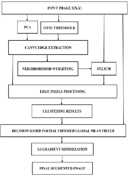
3. PROPOSED ALGORITHM
This section contains the flow chart of the proposed algorithm. This algorithm is able to segment the various images like remote sensing and underwater images. Figure 1 shows the different steps of required achieving the segmentation through proposed algorithm.
Fig 1: Flowchart of Proposed Algorithm
4. RESULTS AND DISCUSSIONS
4.1 Experimental Setup
Figure 2 has shown the results of segmentation of remote sensing image from existing technique and proposed technique.
Figure 2 (a) Original Image (b) Segmented Image of Existing Technique (c) Segmented Image of proposed
Technique
Figure 2(a) shows the Original remote sensing image and figure 2(b) shows the result of segmentation of remote sensing image from existing technique. Figure 2(c) shows the result of segmentation of remote sensing image from proposed technique. So it has clearly shown that result of proposed technique gives the better result as compared to the result of existing technique.
4.2 Performance Evaluation
The proposed algorithm is also tested on various remote sensing images. The algorithm is applied using various performance indices Bit Error Rate (BER), Average Difference and Accuracy.
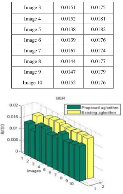
4.2.1 Bit Error Rate Evaluation
[image:3.595.313.549.122.411.2]Table 1 is showing the comparative analysis of the Bit Error Rate. As Bit Error Rate needs to be minimized; so the main objective is to reduce the Bit Error Rate as much as possible. Table 1 has clearly shown that Bit Error Rate is less in our case therefore the proposed algorithm has shown significant results over the existing algorithm.
Table 1: BER
Remote Sensing
Images
Proposed
Technique
Existing
Technique
[image:3.595.61.279.443.743.2] [image:3.595.337.516.677.757.2]Image 3 0.0151 0.0175 Image 4 0.0152 0.0181 Image 5 0.0138 0.0182 Image 6 0.0139 0.0176 Image 7 0.0167 0.0174 Image 8 0.0144 0.0177 Image 9 0.0147 0.0179 Image 10 0.0152 0.0176
Fig 3: BER Evaluation
Figure 3 has shown the quantized analysis of the Bit Error Rate of different remote sensing images by Proposed Approach. It is very clear from the plot that there is decrease in BER value of natural images with the use of proposed method over existing method.
4.2.2 Average Difference Evaluation
[image:4.595.62.273.69.401.2]Table 2 is showing the comparative analysis of the Average Difference. As Average Difference needs to be minimized; so the main objective is to reduce the Average Difference as much as possible. Table 2 has clearly shown that Average Difference is less in our case therefore the proposed algorithm has shown significant results over the available algorithm.
Table 2: Average Difference
Remote Sensing Images
Proposed Technique
Existing Technique
Image 1 0.0132 0.1338 Image 2 0.0061 0.0067 Image 3 0.0463 0.3725 Image 4 0.0536 0.5671 Image 5 0.0115 0.6441 Image 6 0.0123 0.4101 Image 7 0.2104 0.3433 Image 8 0.0226 0.4512 Image 9 0.0305 0.5033 Image 10 0.0536 0.4086
Figure 4 has shown the quantized analysis of the Average Difference of different remote sensing images using Proposed Approach. It is very clear from the plot that there is decrease in Average Difference value of images with the use of proposed method over existing method. These decreased values represent the improvement in the objective quality of the image.
Fig 4: Average Difference Evaluation
4.2.3 Accuracy Rate Evaluation
[image:4.595.329.540.148.300.2]Table 3 is showing the comparative analysis of the Accuracy rate. As accuracy needs to be maximized; so the main objective is to increase the accuracy rate as much as possible. Table 3 has clearly shown that accuracy rate is increased in our case therefore the proposed algorithm has shown significant results over the existing algorithm.
Table 3: Accuracy Rate
Remote Sensing Images
Existing Technique
Proposed Technique
Image 1 0.8662 0.9177 Image 2 0.9933 0.9952 Image 3 0.7275 0.8921 Image 4 0.7329 0.9330 Image 5 0.8589 0.9503 Image 6 0.7899 0.9812 Image 7 0.7567 0.8680 Image 8 0.8488 0.9361 Image 9 0.8966 0.9391 Image 10 0.7913 0.8984
[image:4.595.330.538.414.741.2] [image:4.595.82.258.583.746.2]Figure 4 has shown the quantized analysis of the Accuracy Rate of different remote sensing images using Proposed Approach. It is very clear from the plot that there is increase in Average Difference value of remote sensing images with the use of proposed method over existing method. These increased values represent the improvement in the objective quality of the image.
5. CONCLUSION AND FUTURE SCOPE
Remote sensing images have significant applications in different areas such as urban planning, surveys and mapping, agriculture analysis, environmental monitoring and military intelligence. The goal of segmentation is to make simpler or modify the representation of an image to some extent that is more important and not difficult to analyze. Image segmentation is generally used to find objects and edges in images. More accurately, image segmentation is the process of passing on a label to every pixel in an image in a way that all pixels with the same label split definite optical characteristics. In this paper, new hybrid image segmentation by using FELICM, L0 gradient minimization and the progressive switching median filter has been proposed. The effectiveness of the proposed technique has been evaluated on different kinds of images. Various performance metrics have been evaluated which showed the improvement of the proposed technique. The method has been very much effective for underwater images, remote sensing and natural images. In near future we will modify the proposed technique further by using the well known filters.
6. REFERNCES
[1] Patel, Chirag, Atul Patel, and Dipti Shah. "Threshold Based Image Binarization Technique for Number Plate Segmentation."International Journal3, no. 7 (2013). [2] Jie Feng, L.C. Jiao, Xiangrong Zhang, Maoguo Gong, Tao
Sun, “Robust non-local fuzzy c-means algorithm with edge preservation for SAR image segmentation.” Signal Processing, Volume 93, Issue 2, March 2013.
[3] Manju, Dr. M. Seetha, and K. Venugopala Rao, "Comparison Study of Segmentation Algorithms for Brain Tumor Detection" IJCSMC, Vol. 2, Issue. 11, November 2013, pg.261 – 269 (2013)
[4] Madasu Hanmandlu, Om Prakash Verma, Seba Susan, V.K. Madasu, “Color Segmentation by Fuzzy co-clustering color features.” Neurocomputing, volume 120, November 2013.
[5] Amanjot Kaur Randhawa, Dr. Rajiv Mahajan, “Evaluating the Short Comings of Clustering based Segmentation Algorithms”(2014)
[6] Pankaj Jain, Dr. Mohan Awasthy. “Automatic Obstacle Detection using Image Segmentation.” International Journal of Emerging Technology and Advanced Engineering, Volume 4, Issue 3, March (2014).
[7] Dr. Rajiv Mahajan, Amanjot Kaur Randhawa, “An Improved Approach towards Image Segmentation Using Mean Shift and FELICM.” International Journal of Advanced Research in Computer Science and Software Engineering, Volume 4, Issue 7,
[8] Kelvin J. Bhalodiya, Prof. Kaushal doshi, Kelvin, “Performance evaluation of different Segmentation algorithms for Underwater and Arial images.” International Journal of Research in Computer and Communication Technology, Vol 3, Isue 1, January- 2014. [9] Ramya, Jemimah Simon, “Image Segmentation Using FELICM Clustering Method.” International Journal of Engineering Research and Applications (IJERA) ISSN: 2248-9622 (01st March 2014).
[10] R.Ilanthiraiyan, V.M.Navaneetha Krishnan, “Spatial clustering method for satellite image segmentation”(2014)
[11] Shivendra Singh, Manish Soni, Ravi Shankar Mishra, “Segmentation of Underwater Objects using CLAHE Enhancement and Thresholding with 3-class Fuzzy C-Means Clustering.” International Journal of Emerging Technology and Advanced Engineering, Volume 4, Issue 4, April 2014.
[12] Tapinder Kaur, Ashish Verma, “Structure Extraction from Complex Textures using Gradient based Relative Total Variation.” International Journal of Innovative Technology and Exploring Engineering (IJITEE) ISSN: 2278-3075, Volume-3, Issue-8, January 2014.
[13] Zuoyong Li, Kezong Tang, Yong Cheng, Yong Hu, “Transition region based single-object image Segmentation.” International Journal of Electronics of Communication (AEU) July 2014.
[14] Zhijian Huang, Xiang Li, Hui Zhang, “Remote Sensing Image Segmentation based on Dynamic Statistical Region Merging.” International journal for light and Electron Optics, Vol. 125, Issue 2, January 2014.