1
Mobile Crowdsensing: Current State and
Future Challenges
Raghu K. Ganti, Fan Ye, and Hui Lei
IBM T. J. Watson Research Center, Hawthorne, NY
rganti,fanye,[email protected]
✦
Abstract—An emerging category of devices at the edge of the Internet are consumer centric mobile sensing and computing devices, such as smartphones, music players, and in-vehicle sen-sors. These devices will fuel the evolution of the Internet of Things as they feed sensor data to the Internet at a societal scale. In this paper, we will examine a category of applications that we term mo-bile crowdsensing, where individuals with sensing and computing devices collectively share data and extract information to measure and map phenomena of common interest. We will present a brief overview of existing mobile crowdsensing applications, explain their unique characteristics, illustrate various research challenges and discuss possible solutions. Finally we argue the need for a unified architecture and envision the requirements it must satisfy.
1
I
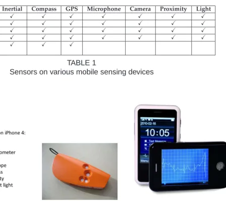
NTRODUCTIONThe integration of sensing and embedded everyday computing devices at the edge of the Internet will result in the evolution of an embedded Internet or the Internet of Things. Typical IoT devices include physical items tagged/embedded with sensors (e.g. chemical containers with temperature sensors), scis-sors with IC-tags, and smart meters to remotely monitor energy consumption. An emerging cate-gory of edge devices that we believe will result in the evolution of Internet of Things are con-sumer centric mobile sensing and computing de-vices, which are connected to the Internet. These in-clude smartphones (iPhone, Google Nexus), music players (iPods), sensor embedded gaming systems (Wii, XboX Kinect), and in-vehicle sensing devices (GPS, OBD-II). They have become extremely pop-ular recently and are potentially important sources of sensor data. They are typically equipped with various sensing faculty and wireless capabilities that allow them to produce data and upload the data to the Internet. As an example, a sample list
of mobile devices and their corresponding sens-ing capabilities are provided in Table 1. Future sensing capabilities on smartphones include ECG (for medical purposes, e.g. ithlete, H’andy Sana), poisonous chemical detection (e.g. cell-all), and air-quality sensors (e.g. Intel’s EPIC, Figure 1).
Different from the ”typical” everyday IoT ob-jects (e.g., coffee machines) that traditionally lack computing capabilities, these mobile devices have a variety of sensing, computing and communication faculty. They can serve either as a bridge to other everyday objects, or generate information about the environment themselves. We believe they will drive a plethora of IoT applications that elaborate our knowledge of the physical world.
These applications can be broadly classified into two categories, personal and community sensing, based on the type of phenomena being monitored. In personal sensing applications, the phenomena is pertaining to an individual. For example, the monitoring of movement patterns (e.g. running, walking, exercising) of an individual for personal record-keeping or healthcare reasons. Another ex-ample of personal sensing is one that monitors the transportation modes of an individual to determine his or her carbon footprint.
On the other hand, community sensing pertains to the monitoring of large-scale phenomena that cannot be easily measured by a single individ-ual. For example, intelligent transportation systems may require traffic congestion monitoring and air pollution level monitoring. These phenomena can be measured accurately only when many individu-als provide speed and air quality information from their daily commutes, which are then aggregated spatio-temporally to determine congestion and
pol-Device Inertial Compass GPS Microphone Camera Proximity Light iPhone 4 X X X X X X X Nexus S X X X X X X X Galaxy S II X X X X X X X HTC Sensation X X X X X X X Garmin X X X ForeRunner 410 TABLE 1
Sensors on various mobile sensing devices
(a) Sensors on Apple’s iPhone 4 (b) Intel’s air quality sensor that communicates with Blue-tooth enabled mobile phones
(c) ECG sensor enabled mobile phone, H’andy Sana
Fig. 1. Sensors on current iPhone 4 and future sensors that will possibly be integrated with mobile phones
lution levels in cities.
Community sensing is also popularly called par-ticipatory sensing [1] or opportunistic sensing [2]. Participatory sensing requires the active involve-ment of individuals to contribute sensor data (e.g. taking a picture, reporting a road closure) related to a large-scale phenomena. Whereas opportunistic sensing is more autonomous and user involvement is minimal (e.g. continuous location sampling with-out the explicit action from the user). We take the position that community sensing spans a wide spectrum of user involvement, with participatory sensing and opportunistic sensing at the two ends. We therefore coin the term mobile crowdsensing (MCS) to refer to a broad range of community sensing paradigms1.
In the rest of this article, we will survey exist-ing crowdsensexist-ing (both participatory and oppor-tunistic) applications (Section 2), identify unique characteristics of MCS applications (Section 3), and discuss the research challenges they face, their solu-1. The notion that crowdsensing spans a spectrum from partic-ipatory sensing to opportunistic was suggested by our colleague Thomas Erickson
tions and tradeoffs. The research challenges that we discuss include: (i) Localized analytics, (ii) Resource limitations, (iii) Privacy, security, and data integrity, (iv)Aggregate analytics, and (v)Architecture.
2
M
OBILEC
ROWDS
ENSINGA
PPLICA-TIONS
In this section, we will briefly discuss existing mobile crowdsensing applications, which provide a basis for illustrating various research challenges in the rest of this article. We classify MCS applications into three different categories based on the type of phenomenon being measured or mapped. These include (i)Environmental, (ii)Infrastructure, and (iii)
Social.
In environmental MCS applications, the phenom-ena are those of the natural environment. Exam-ples include measuring pollution levels in a city, water levels in creeks, and monitoring wildlife habitats. Such applications enable the mapping of various large scale environmental phenomena by involving the common man. An example prototype deployment for pollution monitoring is Common
Sense [3]. Common Sense uses specialized hand-held air quality sensing devices that communicate with mobile phones (using Bluetooth) to measure various air pollutants (e.g. CO2, NOx). These
de-vices when deployed across a large population, col-lectively measure the air quality of a community or a large area. Similarly, one can utilize microphones on mobile phones to monitor noise levels in com-munities. Another example is CreekWatch devel-oped by IBM Almaden Research Center. It monitors water levels and quality in creeks by aggregating reports from individuals, such as pictures taken at various locations along the creek, or text messages about the amount of trash. Such information can be used by the water control boards to track pollution levels in water resources.
Infrastructure applications involve the measure-ment of large scale phenomena related to public infrastructure. Examples include measuring traffic congestion, road conditions, parking availability, outages of public works (e.g. malfunctioning fire hydrants, broken traffic lights), and real-time transit tracking. Early MCS deployments measured traf-fic congestion levels in cities, examples of which include MIT’s CarTel [4] and Microsoft Research’s Nericell [5]. CarTel utilizes specialized devices in-stalled in cars to measure the location and speed of cars and transmit the measured values using public WiFi hotspots to a central server. This central server can then be queried to provide information such as least delay routes or traffic hotspots. On the other hand, Nericell utilizes individuals’ mobile phones to not only determine average speed or traffic delays, but also detect honking levels (especially in countries like India where honking is common) and potholes on roads. Another example is ParkNet [6], an application that detects available parking spots in cities using ultrasonic sensing devices installed on cars combined with smart phones.
Finally, the third category is social applica-tions, where individuals share sensed information amongst themselves. As an example, individuals can share their exercise data (e.g. how much time one exercises in a day) and compare their exercise levels with the rest of the community. They can use this comparison to help improve their daily exercise routines. Example deployments include BikeNet [7] and DietSense [8]. In BikeNet, individuals measure location and bike route quality (e.g. CO2 content
on route, bumpiness of ride) and aggregate the data to obtain “most” bikeable routes. In DietSense,
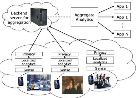
individuals take pictures of what they eat and share it within a community to compare their eating habits. A typical use case for this is for a community of diabetics to watch what other diabetics eat and control their diet or provide suggestions to others. To summarize, the functioning of typical MCS applications is illustrated in Figure 2, which depicts a number of research challenges as functional com-ponents.
3
MCS: U
NIQUEC
HARACTERISTICSWe will first illustrate the unique characteristics of MCS applications that differentiate them from traditional mote-class sensor networks. This will provide the reader with an idea about the research challenges faced by MCS applications.
Compared to traditional mote-class sensor net-works, mobile crowdsensing has a number of unique characteristics that bring both new oppor-tunities and problems. First, today’s mobile devices have significantly more computing, communica-tion and storage resources than mote-class sen-sors, and they are usually equipped with multi-modality sensing capabilities. These will enable many applications that require resources and sens-ing modalities beyond current mote-class sensors possess. Second, millions of mobile devices are already “deployed in the field”: people carry these devices wherever they go and whatever they do. By leveraging these devices, we could potentially build large scale sensing applications efficiently (cost and time). For example, instead of installing road-side cameras and loop detectors, we can col-lect traffic data and detect congestion levels using smartphones carried by drivers. Such solutions re-duce the cost of deployment of specialized sensing infrastructure.
The dynamic conditions of the set of mobile devices and the need for data reuse across different applications in MCS are also quite different from those of traditional sensor networks. In MCS, the population of mobile devices, the type of sensor data each can produce, and the quality in terms of accuracy, latency, confidence can change all the time due to device mobility, variations in their energy levels and communication channels, and device owners’ preferences. Identifying the right set of devices that can produce the desired data and instructing them to sense with proper parameters to ensure desired quality is a complex problem. In traditional sensor networks, the population and the
Fig. 2. Typical functioning of MCS applications. Raw sensor data are collected on devices and processed by local analytic algorithms to produce consumable data for applications. The data may then be modified to preserve privacy and is sent to the backend for aggregation and mining.
data they can produce are mostly known apriori, thus controlling the data quality is much easier. The same sensor data have been used for different purposes in many existing MCS applications. For example, the accelerometer readings have found us-age in transportation mode identification, pothole detection, human activity pattern extraction. To ef-ficiently support multiple concurrent applications, it is critical to identify common data needs and support the reuse of sensor data across applications. In contrast, a conventional sensor network is typ-ically intended for a single application and reuse for vastly different purposes is rarely needed.
Because devices are owned and carried by indi-vidual users, humans are usually involved in the loop. On one hand, the intelligence and mobility of humans can be leveraged to help applications collect higher quality or semantically complex data that may otherwise require sophisticated hardware and software. For example, humans can easily iden-tify available street parking spots and report with pictures or text messages, whereas an ultrasound based scanning system not only requires special hardware but also sophisticated processing
algo-rithms to ensure the reliability of data. On the other hand, humans naturally have privacy con-cerns and personal preferences that are not nec-essarily aligned with the end goals of the MCS applications. The user may not want to share sensor data that contains or reveals private and sensitive information, such as their current location.
Another important implication for human in-volvement are incentives. Participating individuals (devices) may incur energy, monetary costs or even explicit efforts on the owner of the device for sens-ing, processing and communicating of desired data. Unless there are strong enough incentives, the own-ers may not be willing to contribute their resources. For MCS applications to succeed, there have to be appropriate incentive mechanisms to recruit, engage, and retain human participants. Elaboration on incentive mechanisms and other people-oriented tools are beyond the scope of this paper, since our focus is on system challenges.
4
L
OCALIZEDA
NALYTICSVarious sensors such as GPS, accelerometer, micro-phone and camera are available on mobile devices.
The OS allows applications to access the sensors and extract raw sensing data from them. However, depending on the nature of the raw data and the needs of applications, the physical readings from sensors may not be suitable for the direct con-sumption of applications. Many times, some local analytics performing certain primitive processing of the raw data on the device are needed. They produce intermediate results which are sent to the backend for further processing and consumption. For example, in a pothole detection [5] application, a local analytic computes spikes from 3-axis accel-eration sensor data to determine potential potholes. The motivation of such local analytics are two-fold. First, the kind of processing performed leads to appropriately summarized data, thus consuming lesser energy and bandwidth than transmitting the raw sensor readings. This is a well-known tradeoff in conventional mote-class sensor networks: using computation to save energy/bandwidth. Second, it reduces the amount of processing that the backend has to perform. Further, if the mobile devices in a societal scale deployment transmit raw sensor data, the backend can easily be overwhelmed. Finally, some applications are delay sensitive and transmit-ting raw sensor data on intermittently connected channels can be time consuming as compared to that of sending processed sensor data.
The main challenge in local analytics is finding heuristics and designing algorithms to achieve the desired function. One category of functions isdata mediation, such as filtering of outliers, elimination of noise, or filling in data gaps. For example, GPS samples acquired may not be accurate or missing (due to lack of line of sight), in which event, outliers need to be eliminated or missing samples extrapolated.
Another common category of functions are con-text inference. Examples of context include trans-portation mode (whether the user in on a car, bus, train, or on foot), the kinetic modes of humans (walking, standing, jogging, running), the social settings (e.g., in a meeting, having a phone call, watching TV, etc.), or the occurrence of certain events in the surrounding environments (e.g., pot-holes on road, stop-and-go traffic, loud noise lev-els). The heuristics and algorithms needed can be quite application specific. Hence, the exact algo-rithm used for context inference depend on the nature of the application and the characteristics of the context. The current practice is to develop
analytics solely for one application. This could leads to an ”explosion” of analytics when many crowdsensing applications co-exist. Each analytic is working individually and there is possibility that they may be accessing the same sensor, or involve similar computation in their inference.
5
R
ESOURCEL
IMITATIONS:
E
NERGY,
B
ANDWIDTH,
ANDC
OMPUTATIONEven though they possess much more computing, bandwidth, and energy resources than mote-class sensors, mobile devices nevertheless face resource limitations. Resource constraints in traditional sen-sor networks have been well studied. However, MCS applications introduce new aspects in this regard.
First, the set of devices that are collecting sen-sor data are highly dynamic in availability and capabilities. Due to this highly dynamic nature, modeling and predicting the energy, bandwidth requirements to accomplish a particular task is harder than traditional sensor networks. Second, when there are a large number of available de-vices with diverse sensing capabilities, identifying and scheduling sensing and communication tasks among them under resource constraints is more complex.
Another interesting aspect is the interdependen-cies between various types of sensory data due to multi-modality sensing capabilities. Different types of data can be used for the same purpose, but with different quality and resource consumption tradeoffs. Leveraging these differences to improve the quality while minimizing resource consumption is a novel challenge. For example, location data can be provided using GPS, WiFi, and GSM, with de-creasing levels of accuracy. Compared to WiFi and GSM, continuous GPS location sampling drains the battery faster. One approach to this problem uses low duty cycling to reduce energy consumption of high quality sensors (i.e., GPS), and alternates between high and low quality sensors depending on the energy levels of the device (e.g. sample WiFi often when battery level is less than 70%). This approach trades off data quality and accuracy for energy.
The existence of multiple concurrent applications that require data of different types also compli-cates resource allocation. A mobile device can be sampling various sensors (e.g. GPS, accelerome-ter, air quality) on behalf of different applications.
The approach proposed by CarTel prioritizes data collection tasks. Depending on the priority of the application that requires sensor data, the sampling rate of other sensors can be reduced (or the sensor completely switched off). For example, during peak travel times, a community may be more interested in obtaining traffic congestion levels as opposed to air or noise pollution levels. As a result, the air/noise sensors sample much less frequently or can be shut down.
A drawback of existing solutions such as low duty cycling are that they are designed for their particular application context and do not scale when many different applications co-exist. An im-portant challenge for large scale deployment of MCS applications is that the resource constraints need to be addressed in a holistic manner. How do multiple applications on the same device uti-lize energy, bandwidth, and computation resources without significantly affecting the data quality of each other? How does scheduling of sensing tasks occur across multiple devices with diverse sensing capabilities and availabilities (which can change dynamically)? We believe that these questions need to be answered before MCS applications can be deployed on a large scale.
6
P
RIVACY, S
ECURITY,
ANDD
ATAI
N-TEGRITY
An important aspect of MCS applications is that they potentially collect sensitive sensor data per-taining to individuals. For example, GPS sensor readings can be utilized to infer private informa-tion about the individual, such as the routes they take during their daily commutes, home, and work locations [9]. On the other hand, these GPS sen-sor measurements (from daily commutes) shared within a larger community can be used to obtain traffic congestion levels in a given city [4]. Thus, it is important to preserve the security and privacy of an individual, but at the same time enable MCS applications. It is also necessary to ensure that an individual’s sensor data is not revealed to un-trustworthy third parties. A problem that arises from the opt-in nature of crowdsensing applications is when malicious individuals contribute erroneous sensor data (e.g. falsified GPS readings), maintain-ing the integrity of sensor data collected is an important problem. In what follows, we will briefly touch on these challenges.
A popular approach for preserving privacy of the data is that of anonymization [10] which re-moves any identifying information from the sen-sor data before sharing it with a third party. The drawback of such an approach is that anonymized GPS (or location) sensor measurements can still be used to infer the frequently visited locations of an individual and derive their personal details. Another approach for preserving privacy is secure multiparty computation [11], where cryptographic techniques are used to transform the data in order to preserve privacy. Such cryptographic techniques are compute intensive and are not scalable be-cause they require the generation and maintenance of multiple keys, which also leads to higher en-ergy consumption. We believe thatdata perturbation
based approaches, which add noise to sensor data before sharing it with the community to preserve privacy of an individual, are appropriate. The data perturbation approaches [12], [13] rely on adding noise in such a manner that the privacy of an individual is preserved, but at the same time it is possible to compute the statistics of interest with high accuracy (due to the nature of the noise being added). For example, in a weight watchers applica-tion, it is important to compute the average weight of the population. Each individual i is sensitive
to revealing his or her weight (wi) and perturbs
it by adding a random number (ri), which is
drawn from a known distribution with zero mean. Although individual weights are perturbed and appear random, when these values are averaged, the randomized component (Pri) vanishes (given
sufficient number of individuals) and the average weight of the community can be computed with a high degree of accuracy.
Data integrity, ensuring the integrity of sensor data generated by individuals, needs to be ad-dressed by MCS applications. Some approaches have been proposed in existing literature [14], [15], which rely on co-located infrastructure as a wit-ness. Such an approach relies on inputs from the installation of expensive infrastructure, which can be prohibitive and unavailable at times. Another approach is to sign the sensor data (by trusted hardware installed on mobile phones). However, this approach is potentially problematic as the verification has to be done even in the software. For example, a GPS location may be perturbed by adding noise for privacy reasons or audio sensor data may be processed to conserve energy.
We make a few observations in regard to privacy, security, and data integrity for MCS applications. First, we observe that privacy is very user specific, that is each individual has a different perception of privacy. For example, one person may be willing to share his or her location information continu-ously whereas another may not. Developing pri-vacy techniques that address variation in individual preferences is needed. Further, a generic pertur-bation technique or a framework of perturpertur-bation techniques need to be developed such that privacy and security can be achieved in a generic setting independent of the nature of the data being shared. Finally, real world MCS deployments must address the data integrity problem in order to provide meaningful conclusions from the aggregate sensor data.
7
A
GGREGATEA
NALYTICSThe local analytics running on mobile devices only analyze data on the given device. MCS applications rely on analyzing the data from a collection of mo-bile devices, identifying spatio-temporal patterns. For example, the transportation authority of a city may be interested in the spatial distribution of traf-fic hot spots around the road network, and how the distribution evolves over various time scales. Such insight can help them better coordinate the traffic lights to ease traffic depending on the time of the day, and better plan future road expansions in the long term to reduce congestion. Another example is for public works maintenance. Citizens can report problems in public facilities, such as broken water pipes, dysfunctional traffic lights. Such reports can be used by the maintenance personnel to infer (to a certain degree) the impact and severity of the incident to help prioritize and schedule the repair resources.
The patterns may also help users build models and make predictions about the physical or social phenomena being observed. One example is the monitoring of pollutants such as car exhaust. An important aspect of environment protection is to build models to understand the dissemination of pollutants in the air, soil and water. By collecting large amount of data samples about air pollutants such as car exhaust, one can not only monitor the concentration of pollution, but also detect patterns to model how the concentration evolves spatially and temporally as temperature, humidity and wind
change. These models can help the environmental authority forecast and provide alerts to the public. The challenge in identifying patterns from large amount of data is usually application specific and it involves certain data mining algorithms. Depend-ing on the amount of incomDepend-ing data, and the delay sensitivity of applications, there are two possible approaches for data mining. One is a traditional approach where data is stored in a database first and then one can apply various mining algorithms against the database to detect patterns. However, if the amount of continuous data input is too much for storage, or the application requires fast detec-tion of patterns, stream data mining algorithms may be required. Such algorithms take as input con-tinuous data streams and identify patterns, without the need to first store the data. Data mining algo-rithms are domain specific and the exact algoalgo-rithms will be closely related to the application and are out of scope of this paper.
8
A
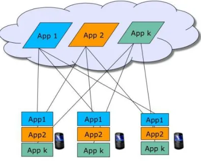
RCHITECTUREIn this section, we illustrate the current state of the architecture of existing MCS applications and point out its drawbacks. Currently, a typical MCS ap-plication has two apap-plication specific components, one on the device (for sensor data collection and propagation) and the second in the backend (or cloud) for the analysis of the sensor data to drive the MCS application. This architecture is depicted in Figure 3. We refer to this as application silos
because each application is built ground-up and independent from each other. There is no common component even though each application faces a number of common challenges in data collection, resource allocation and energy conservation.
Such an architecture hinders the development and deployment of MCS applications in several ways. First, it is hard toprograman application. To write a new application, the developer has to ad-dress challenges in energy, privacy, and data quality in an ad hoc manner, reinventing the wheel all the time. Further, he may need to develop different variants of local analytics if he wants to run the ap-plication on heterogeneous devices using different OSes. Second, this approach is inefficient. Applica-tions performing sensing and processing activities independently without understanding the conse-quences on each other will result in low efficiency on an already resource constrained platform. There
Further Reading
As such, extensive research has been conducted in each of the above addressed problems and we provide some further readings in this break-out box.
Localized Analytics
• Cooperative transit tracking using GPS-enabled smart-phones, A. Thiagarajan et. al., In Proceedings of SenSys 2010,
pp. 85-98.
• Sensing meets mobile social networks: The design, implementation, and evaluation of the CenceMe application,E. Miluzzo et. al., In Proceedings of SenSys 2008, pp. 337-350.
Resource Limitations
• Accurate, low-energy trajectory mapping for mobile devices,A. Thiagarajan et. al., In Proceedings of NSDI 2011. • Energy-delay tradeoffs in smartphone applications,Moo-Ryong Ra et. al., In Proceedings of MobiSys 2010, pp. 255-270. • Augmenting mobile 3G using WiFi: Measurement, design, and implementation,A. Balasubramanian, R. Mahajan, and
A. Venkataramani, In Proceedings of MobiSys 2010, pp. 209-222. Privacy, Security, and Data Integrity
• I am a sensor, and I approve this message,S. Saroiu and A. Wolman, In Proceedings of HotMobile 2010, pp. 37-42. • Toward trustworthy mobile sensing, P. Gilbert, L. Cox, J. Jung, D. Wetherall, In Proceedings of HotMobile 2010, pp.
31-36.
• Opportunistic sensing: security challenges for the new paradigm, A. Kapadia, D. Kotz, and N. Triandopoulos, In
Proceedings of COMSNETS 2009, pp. 127-136. Aggregate Analytics
• MoveMine: Mining moving object data for discovery of animal movement patterns,Z. Li, et. al., In ACM Transactions
on Intelligent Systems and Technology, August 2010
• iMap: Indirect measurement of air pollution with cellphones,M. Demirbas et. al., In Proceedings of PerCom, 2009, pp.
1-6. Architecture
• NORS: An open source platform to facilitate participatory sensing with mobile phones, D. Trossen and D. Pavel, In
Proceedings of MobiQuitous 2007, pp. 1-8.
• PEIR, the personal environmental impact report, as a platform for participatory sensing systems research,M. Mun et. al., In Proceedings of MobiSys 2009, pp. 55-68.
• A Rich Services Approach to CoCoME,B. Demchak et. al., In LNCS, vol. 5153, pp. 85-115, August 2008.
Fig. 3. Existing MCS applications take an ”application silo” approach where each application is built from scratch without any common component even though they face many common challenges. Such an architecture hinders the development of new MCS applications and we envision a unifying architecture should address its limitations.
is a high likelihood of duplicating sensing and pro-cessing across multiple applications. For example, traffic sensing, air and noise pollution all require location information, but these applications would each do its own sampling without reusing the same data samples. Further, there is no collaboration or coordination across devices. Devices may not all be needed (e.g. traffic sensing in a given location) especially when the device population is dense. Finally, the current architecture is notscalable. Only a small number of applications can be accommo-dated on each device (e.g. limitations imposed by the device operating system, human capacity to keep track of a large number of applications). Also, the data gathered from societal-scale sensing may overwhelm network and backend server capacities, thus making the current architecture non-scalable.
We envision that a unifying architecture could address the current limitations of how MCS appli-cations are developed and deployed. It will satisfy the common needs for multiple different appli-cations. First, it should allow application devel-opers to specify their data needs in a high level language. It should identify common data needs across applications to avoid duplicate sensing and processing activities on devices. Second, it should automatically identify the set of devices that can provide the desired data, and produce instructions to configure the sensing activities on devices prop-erly. When dynamic changes happen, it should adapt the set of chosen devices and sensing instruc-tions to ensure the desired data quality. Finally, to avoid writing different versions of local analytics on heterogeneous devices, a layer that can shield the differences in physical sensor access APIs and provide the same API upwards is necessary. This makes it possible to reuse the same local analytics across different device platforms, assuming these platforms all support a common programming lan-guage such as Java.
9
C
ONCLUSIONS ANDF
UTUREW
ORK In conclusion, we have identified a category of IoT applications that rely on data collection from large number of mobile sensing devices such as smartphones, which we termed mobile crowdsens-ing (MCS). We presented several MCS applications, such as CarTel, Nericell, ParkNet, BikeNet, and DietSense. We then identified the unique character-istics of MCS, presented several research challenges of MCS and discussed their solutions briefly. Wealso note that due to space limitations, we have not presented all of the existing work (in terms of applications as well as the individual research challenges). We are currently exploring a unified architecture for collecting and processing sensor data from mobile sensing devices at a societal scale.
A
CKNOWLEDGEMENTSWe would like to thank our team members, Joel Branch, Han Chen, Sastry Duri, Minkyong Kim, Johnathan Reason, and Zhe Zhang for the several stimulating discussions that provided the basis for this paper. Further, we would also like to thank Maria Ebling, Thomas Erickson, and Wendy Kellog for their valuable inputs to this paper.
R
EFERENCES[1] J. Burkeet al., “Participatory sensing,” Workshop on World-Sensor-Web, co-located with ACM SenSys, 2006. [Online]. Available: http://www.sensorplanet.org/wsw2006/ [2] N. Laneet al., “A survey of mobile phone sensing,”IEEE
Communications Magazine, vol. 48, no. 9, pp. 140–150, 2010. [3] P. Duttaet al., “Demo abstract: Common sense: Participa-tory urban sensing using a network of handheld air quality monitors,” inProc. of ACM SenSys, 2009, pp. 349–350. [4] B. Hullet al., “Cartel: a distributed mobile sensor
comput-ing system,” inProc. of SenSys, 2006, pp. 125–138. [5] P. Mohan, V. Padmanabhan, and R. Ramjee, “Nericell: Rich
monitoring of road and traffic conditions using mobile smartphones,” inProc. of ACM SenSys, 2008, pp. 323–336. [6] S. Mathur et al., “Parknet: Drive-by sensing of road-side
parking statistics,” inProc. of ACM MobiSys, 2010, pp. 123– 136.
[7] S. B. Eisenmanet al., “The bikenet mobile sensing system for cyclist experience mapping,” inProc. of SenSys, Novem-ber 2007.
[8] S. Reddyet al., “Image browsing, processing, and clustering for participatory sensing: Lessons from a dietsense proto-type,” inProc of EmNets, 2007, pp. 13–17.
[9] J. Krumm, “A survey of computational location privacy,”
Personal and Ubiquitous Computing, vol. 13, no. 6, pp. 391– 399, 2009.
[10] L. Sweeney, “k-anonymity: A model for protecting pri-vacy,” International Journal of Uncertainty, Fuzziness, and Knowledge-based Systems, vol. 10, no. 5, pp. 557–570, October 2002.
[11] A. Yao, “Protocols for secure computations,” in Proc. of IEEE Symposium on Foundations of Computer Science, 1982, pp. 160–164.
[12] R. Agrawal and R. Srikant, “Privacy preserving data min-ing,” in Proc. of ACM Conf. on Management of Data, May 2000, pp. 439–450.
[13] R. K. Ganti, N. Pham, Y.-E. Tsai, and T. F. Abdelzaher, “Poolview: Stream privacy for grassroots participatory sensing,” inProc. of SenSys ’08, 2008, pp. 281–294. [14] V. Lenders, E. Koukoumidis, P. Zhang, and M. Martonosi,
“Location-based trust for mobile user-generated content: Applications, challenges, and implementations,” inProc. of HotMobile, 2008, pp. 60–64.
[15] S. Saroiu and A. Wolman, “Enabling new mobile applica-tions with location proofs,” inProc. of HotMobile, 2009, pp. 1–6.