EXECUTIVE SUMMARY
GROUNDWATER MASTER PLAN OVERVIEW
ES.1
The overall objective of the City of Santa Rosa (City) Groundwater Master Plan is to provide a strategic road map for the City’s Utilities staff, Board of Public Utilities (BPU), and City Council of how available groundwater resources could be most effectively used, in a sustainable manner, to meet the needs of the City’s existing and future customers. This Groundwater Master Plan provides background information on the City’s historical use of groundwater, descriptions of on-going studies, recommendations for an emergency groundwater supply plan, development of a key well monitoring network, and a conceptual evaluation of the potential use of aquifer storage and recovery wells. Included in the preparation of this Groundwater Master Plan is the development of recommended groundwater policies designed to guide the future role of groundwater and promote balanced use and sustainability for the groundwater resources available to the City. Based on these recommended policies, specific groundwater projects and programs have been identified and prioritized to implement the direction of the BPU.
The development of this Groundwater Master Plan comes at an important time for the City. The United States Geological Survey (USGS) is nearing completion of a comprehensive study of the Santa Rosa Plain groundwater basin, and a groundwater management plan for the Santa Rosa Plain groundwater basin is being prepared by key stakeholders. The City has been actively involved in both of these cooperative projects, as well as its own groundwater test well drilling program to evaluate local groundwater conditions. Available information from these studies has been incorporated into this Groundwater Master Plan to provide for a comprehensive evaluation of the City’s groundwater resources.
When the development of the Groundwater Master Plan was initiated by the City, it was anticipated that the USGS study of the groundwater basin would have been completed by spring 2012. As of the date of this Groundwater Master Plan, the USGS study has not been completed and no information has been published. Due to the lack of the USGS study data and modeling results, there was not enough information available for this Groundwater Master Plan to analyze whether additional groundwater could be used to meet current and future water supply need on a production basis. Once the USGS study data and modeling results are available, the City will consider the information when analyzing whether groundwater resources should be used to meet current and future water supply need. Should the analysis result in any recommended actions, the City would consider updating the Groundwater Master Plan at that time and any needed California Environmental Quality Act (CEQA) analysis would be performed prior to approval of any changes to the Groundwater Master Plan.
BACKGROUND
ES.2
ES.2.1Historical Use of Groundwater
Prior to June 1959, the City’s water supply was primarily composed of groundwater, and was supplemented with some surface water from Santa Rosa Creek impounded behind Lake Ralphine. In 1952, the City Council passed a resolution declaring its intention and willingness to contract with the Sonoma County Water Agency (Agency) for a supply of Russian River water. In 1956, the City’s BPU authorized the issuance of Water Revenue Bonds to upgrade the water system to provide for the City’s connection to the Agency’s Aqueduct. On June 17, 1959, the City’s groundwater production facilities were put on standby for emergency purposes and the Agency became the primary water supply source for the City’s customers. Since then, the City has relied almost exclusively on water provided by the Agency1.
In 1998, the City identified the need to develop an additional 8.7 million gallons per day (mgd) of emergency groundwater supply in the event of an Agency supply outage and established a Capital Improvement Project (CIP) fund to investigate the groundwater resources underlying the City. One of the objectives of this Groundwater Master Plan is to reevaluate this emergency groundwater supply target based on existing and projected future demand conditions within the City’s Urban Growth Boundary.
ES.2.2Policy Direction on Groundwater
In September 2003, the City Council directed Utilities staff to ask the BPU to evaluate the role of local groundwater supply in meeting the water supply needs of the City’s General Plan 2020. In December 2003, the BPU adopted Resolution No. 776 which included the following:
• Directed Utilities staff to pursue water sources to provide reliable water supply through the General Plan Building Horizon;
• Include development of local groundwater, additional recycled water (where it offsets potable use), and other sources as they became available; and
• Evaluate water sources based on supply reliability, cost, timing, and environmental impact.
ES.2.3Exploratory Groundwater Program
Shortly after the passage of Resolution No. 776, Utilities staff developed an exploratory groundwater program to study the City’s groundwater sub-basins, establish a more thorough understanding of the hydrogeologic conditions underlying the City, and investigate and evaluate potential future emergency well sites within the City’s Urban Growth Boundary. To date, eight test borings (test wells) have been
installed, tested and are being monitored by the City. This exploratory program will continue in conjunction with the implementation of this Groundwater Master Plan to assist in identifying locations for new emergency wells in the City.
1
ES.2.4USGS Study of the Santa Rosa Plain
In March 2005, the City entered into a funding agreement for a five-year United States Geological Survey (USGS) Study of the Santa Rosa Plain Groundwater Sub-basin. The cooperative study was conducted by the USGS in partnership with the Agency, County of Sonoma, City of Santa Rosa, City of Rohnert Park, City of Sebastopol, City of Cotati, Town of Windsor, and Cal-American Water Company. The objectives of this study are to develop an updated assessment of the geohydrology, geochemistry and geology of the Santa Rosa Plain
sub-basin, develop a groundwater flow model of the Santa Rosa Plain sub-basin, and evaluate the hydrogeologic impacts of alternative groundwater strategies for the Santa Rosa Plain sub-basin. Completion of the study and model is anticipated by late 2013.
ES.2.5California Statewide Groundwater Elevation Monitoring (CASGEM)
On November 4, 2009 the State Legislature amended the California Water Code with SBx7-6, which mandates a statewide groundwater elevation monitoring program to track seasonal and long-term trends in groundwater elevations in California's groundwater basins. To achieve that goal, the amendment requires collaboration between local monitoring entities and California Department of Water Resources (DWR) to collect groundwater elevation data. In accordance with this amendment to the California Water Code, DWR developed the CASGEM program. The intent of the CASGEM program is to establish a permanent, locally-managed program of regular and systematic monitoring in all of California's alluvial groundwater basins.
The Agency is the designated Monitoring Entity for coordinating the monitoring of groundwater elevations for the Santa Rosa Plain Groundwater Basin for the CASGEM Program. Starting in fall 2011, the City is providing the Agency with groundwater elevation data on a semi-annual basis for selected wells meeting the CASGEM criteria for input into the CASGEM database. Additional information on the CASGEM program is provided in Chapter 2 of this Groundwater Master Plan.
ES.2.6Salt and Nutrient Management Plan
The City is leading the development of a Salt and Nutrient Management Plan for the Santa Rosa Plain Groundwater Sub-basin. The development of such a plan is a requirement of the State Water Resources Control Board Recycled Water Policy which was adopted in 2009. The goals of the State’s Recycled Water Policy are to promote and increase the use of recycled water, to streamline permitting of new water recycling projects and to provide direction to the Regional Boards regarding recycled water project permitting. The Recycled Water Policy requires that Salt and Nutrient Management Plans be developed to manage salts, nutrients, and other significant chemical compounds on a watershed- or basin-wide basis. The Recycled Water Policy also requires that Salt and Nutrient Management Plans be developed through a stakeholder driven process and include a groundwater monitoring plan, goals for water recycling and storm water recharge, salt and nutrient source identification and loading estimates, implementation measures to manage loading, and an anti-degradation analysis. A draft of the
plan was released in July 2012 and the City is collaborating with the Regional Water Quality Control Board to finalize the Salt and Nutrient Management Plan. The City anticipates completion of this process in 2013.
ES.2.7Santa Rosa Plain Groundwater Management Plan
In May 2011, the Agency’s Board directed Agency staff to prepare a work plan and funding agreement with local partners for development of a groundwater management planning process for the Santa Rosa Plain Groundwater Sub-basin. The Work Plan recommended convening a Basin Advisory Panel (BAP) to include stakeholders that participate, contribute, and lead the groundwater management planning process. The BAP consists of about 30 members representing key groundwater interests, including the City.
The development of the Santa Rosa Plain Groundwater Management Plan (SRP GWMP) is currently on-going and is anticipated to be completed by January 2014.
ES.2.8City of Santa Rosa Groundwater Master Plan
In October 2011, the BPU approved the development of a Groundwater Master Plan and the City retained West Yost Associates (West Yost) to prepare this City of Santa Rosa Groundwater Master Plan. The West Yost team also included Environment, Community & Opportunity Network (ECON), to assist with the groundwater database development and coordination with the City’s test well drilling program, and Pueblo Water Resources, Inc. (Pueblo) to assist with evaluation of aquifer storage and recovery.
The development of this Groundwater Master Plan is consistent with the City’s current water supply agreement with the Agency (known as the Restructured Agreement) which contains specific requirements for local supply and recycled water. Section 1.13 of the Restructured Agreement calls for the development of at least 7,500 acre-feet per year (AFY) of recycled water or local supply projects, with approximately 50 percent coming from recycled water projects. Section 1.15 of the Restructured Agreement indicates that it is highly desirable for each water contractor to develop and maintain local water production capacity capable of meeting approximately 40 percent of the water contractor’s average day maximum month demand.
CITY’S EXISTING USE OF GROUNDWATER
ES.3
The City currently operates two production wells, three emergency supply wells and one landscape irrigation well:
• Production Wells: Combined capacity = 2,200 gpm (3.2 mgd, or about 300 acre-feet per month)
— Farmers Lane Well No. 1 (W4-1) — Farmers Lane Well No. 2 (W4-2) • Emergency Supply Wells
— Leete Well (W1): 250 gpm (0.4 mgd) — Carley Well (W2-1): 700 gpm (1.0 mgd) — Peter Springs Well (W2-2): 150 gpm (0.2 mgd) • Landscape Irrigation Well
— Farmers Lane Well No. 3 (W4-3): 300 gpm (0.4 mgd)
In July 2005, the City received permission from the California Department of Public Health (DPH) to use two of its groundwater wells (Farmers Lane Wells Nos. 1 and 2), formerly permitted as standby emergency wells, for full-time, active potable water supply. The City’s annual use of groundwater from the Farmers Lane Wells Nos. 1 and 2 to meet peak summertime demands, starting in 2007, has ranged from 832 to 1,501 acre-feet. The City’s use of groundwater from the Farmers Lane Wells Nos. 1 and 2 is typically limited to the summer and early fall months when peak demands occur (usually July through October), and has ranged from about 150 to 300 acre-feet in those months.
The Leete Well is currently out of service indefinitely due to a casing separation issue, and the Farmers Lane Well No. 3 is only used for landscape irrigation and is no longer connected to the City’s potable water system. All of these wells, except the Leete Well, are drilled in the Santa Rosa Valley Groundwater Basin. The Leete Well is drilled in Sonoma Volcanics.
NEED FOR ADDITIONAL EMERGENCY WELLS
ES.4
In 1906, the City of Santa Rosa was devastated by an earthquake on the San Andreas Fault, measuring 8.2 on the Richter Scale. In 1969, the City experienced two earthquakes on the Rodgers Creek Fault, with a magnitude of 5.2 and 5.3 on the Richter Scale, causing significant damage to infrastructure and unreinforced masonry buildings in the downtown area. The California Division of Mines and Geology estimates the probability of a 7.0 or larger earthquake at 62 percent in the next 30 years.
The impacts of recent major earthquakes around the world (Chile 2010; Christchurch, New Zealand 2010 & 2011; and Japan 2011) have refocused attention on the need for specific response and recovery strategies to restore water service to customers as quickly as possible after a major disaster.
Since the mid 1990’s, the City has had an adopted CIP for the development of 8.7 mgd of emergency groundwater supply suitable for potable water use by the City. This Groundwater Master Plan evaluates and provides recommendations for the City’s development and implementation of an emergency groundwater supply plan to provide for water service to customers should the City’s supply from the Agency be subject to a partial of full outage following a major disaster. This emergency groundwater supply plan evaluates the City’s potential emergency water supply needs under two potential Agency supply outage scenarios to determine the need for and location of emergency groundwater supply wells within the City’s water service area, as follows:
• The first supply outage scenario assumes a full outage of supplies from the Agency as a result from a major earthquake or other event which prevents the Agency from delivering supplies to the City (such as the railcar derailment and formaldehyde spill into the Russian River that occurred in the mid 1970’s that completely shut down the Agency system for about a day).
• The second supply outage scenario assumes a partial outage of supplies from the Agency resulting from a rupture of the Agency’s Santa Rosa Aqueduct where it crosses the Rodgers Creek Fault.
The assumed Agency outage durations include a short-term outage of two (2) days and a long-term outage of fourteen (14) days. The 2-day outage is consistent with criteria recommended by both the American Water Works Association (AWWA) and DPH for emergency supply. The 14-day outage is consistent with DPH’s definition of an emergency well, which can be operated up to 15 days per year.
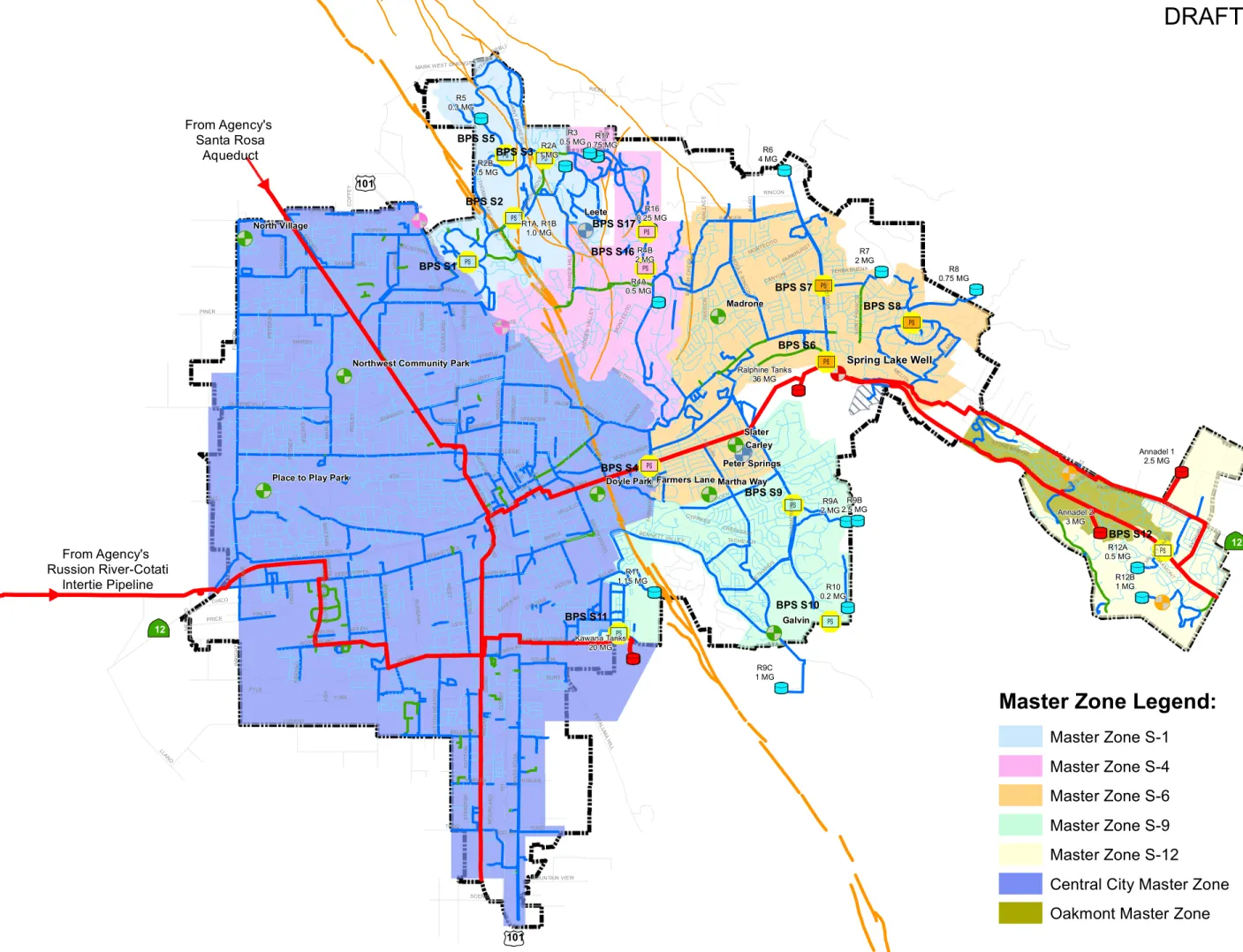
Due to the topography of the City’s water service area, particularly on the east side of the Rodgers Creek Fault, the City’s water distribution system is segregated into a total of 33 distinct pressure zones and subzones. There are 31 Hillside Pressure Zones and two (2) Aqueduct Pressure Zones (Central City and Oakmont). As shown on Figure ES-1, for operational planning purposes, these 33 pressure zones can be grouped into operational “Master Zones” which can be served by a key pump station which can provide water to the other pressure zones within that master zone. For example, in Master Zone S-1, the R1, R2, R3 and R5 pressure zones can all be fed from the S-1 pump station. For purposes of this emergency groundwater supply evaluation, it has been assumed that if supplies can be provided to the key pump station located in each master
zone, supplies can be distributed to most customers in all of the pressure zones located within that master zone, assuming that pump stations and distribution pipelines are operational.
Available supplies and demands in each of the City’s master zones have been evaluated under existing and buildout demand conditions under the two hypothetical Agency outage scenarios described above. Based on this evaluation, up to about 8.4 mgd of additional emergency groundwater supply is required to meet buildout demand conditions assuming a 14-day full loss of the Agency supply. This is in addition to the City’s current emergency groundwater supply of about 4.3 mgd (provided by the Farmers Lane Wells Nos. 1 and 2, Carley Well and Peters Spring Well). This total emergency groundwater supply (about 12.7 mgd) is greater than the City’s previously adopted emergency groundwater target of 8.7 mgd.
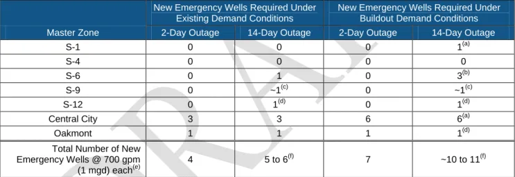
A complete description of the emergency groundwater supply evaluation is provided in Chapter 3 of this Groundwater Master Plan. Table ES-1 provides a summary of the number of required new emergency wells within each of the City’s master zones assuming a full loss of Agency supply.
Table ES-1. Summary of Required New Emergency Wells Assuming Full Loss of Agency Supply
Master Zone
New Emergency Wells Required Under Existing Demand Conditions
New Emergency Wells Required Under Buildout Demand Conditions 2-Day Outage 14-Day Outage 2-Day Outage 14-Day Outage
S-1 0 0 0 1(a)
S-4 0 0 0 0
S-6 0 1 0 3(b)
S-9 0 ~1(c) 0 ~1(c)
S-12 0 1(d) 0 1(d)
Central City 3 3 6 6(a)
Oakmont 1 1 1 1(d)
Total Number of New Emergency Wells @ 700 gpm
(1 mgd) each(e)
4 5 to 6(f) 7 ~10 to 11(f)
(a)
An S-1 emergency well could also be used to serve Central City Master Zone.
(b)
For S-6, three (3) new emergency wells are required under buildout demand conditions assuming a partial Agency outage.
(c)
No problems or issues have been identified in this master zone due to the available supply from the City’s existing Farmers Lane Wells Nos. 1 and 2 (through the pumps at BPS S-4) and the Carley Well and the Peters Spring Well. However, potential new test boring sites should be identified and investigated to determine if an emergency well in Bennett Valley is feasible. If feasible, such an emergency well could provide supply to meet the demands of this master zone and allow increased system operational flexibility to deliver water to Central City from other City emergency wells.
(d)
An S-12 emergency well could also be used to serve Oakmont Master Zone.
(e)
Each new emergency well is assumed to produce 700 gpm (1 mgd). Additional emergency wells may be required if constructed emergency wells are unable to produce 700 gpm. Likewise, fewer emergency wells may be required if constructed emergency wells are able to produce more than 700 gpm. Quantity of emergency supply required in each master zone is shown in Table 3-19.
(f)
The number of required new emergency wells has been reduced to account for emergency wells which can be used to serve multiple areas.
As described above, a number of new emergency wells will be required to meet the City’s emergency groundwater supply needs under the assumed Agency supply outages described herein. Some of the new emergency wells are critically needed to meet existing demand conditions, while others will be needed in the future to meet future demands through buildout. The recommended projects and their timing are summarized below and described in Chapter 7 of this Groundwater Master Plan.
FEASIBILITY OF AQUIFER STORAGE AND RECOVERY
ES.5
In conjunction with the preparation of this Groundwater Master Plan, Pueblo Water Resources, Inc. (Pueblo) prepared a preliminary feasibility-level evaluation of the City’s hydrogeologic setting and a preliminary analysis of the factors affecting potential Aquifer Storage and Recovery (ASR) well capacity at various City-owned well sites (both existing production wells and test well sites).
The overall finding of the evaluation is that ASR wells are technically feasible in certain aquifer zones underlying the City, and if implemented could assist the City in the seasonal storage/offset of peak demands, help stabilize water quality, and assist in increasing the perennial yield of the basin. The findings and conclusions of Pueblo’s evaluation are summarized as follows:
• Sites located in the Bennett and Rincon Valleys completed in Sonoma Volcanics appear to be the most favorable for ASR in terms of theoretical injection and recovery capacities.
• Sites located in the west-central area of the City overlying the Santa Rosa Plain Sub-basin (west of the Rodgers Creek Fault) completed in the Petaluma Formation are moderately favorable for ASR.
• Sites located in the portions of the City overlying the Santa Rosa Plain Sub-basin completed in shallow alluvial fan deposits and/or the Petaluma Formation, as well as those located in areas that are currently under artesian water-level conditions, are the least favorable for ASR.
It is recommended that a more focused analysis of ASR feasibility be conducted at the more favorable locations, including those already identified (e.g., Martha Way, Madrone and Carley) and those which could be identified based on new information developed by the City’s on-going Emergency Test Well Siting Program. This should include identifying candidate well sites for ASR demonstration testing, and evaluating each candidate well site (whether the existing well, or a new well specifically designed for ASR) for ASR demonstration testing.
A complete description of the ASR evaluation is provided in Chapter 5 of this Groundwater Master Plan.
KEY WELL MONITORING NETWORK
ES.6
As part of the development of this Groundwater Master Plan, a Key Well Monitoring Network consisting of existing, strategically located wells throughout the City has been developed to monitor groundwater conditions underlying the City. The goals for the City’s groundwater monitoring program are:
• To develop and maintain a comprehensive groundwater monitoring system that provides the technical data and basis that supports the City in its decisions to sustainably manage its groundwater resources;
• To aid the City in compliance with the CASGEM program;
• To provide data for the Santa Rosa Plain Sub-basin Salt and Nutrient Management Plan; and
• To provide data for the Santa Rosa Plain Groundwater Management Plan.
The groundwater monitoring program will allow the City to monitor both short-term and long-term trends in local groundwater storage and/or quality.
The wells that have been selected for inclusion in the Key Well Monitoring Network are listed in Table ES-2.
Table ES-2. Selected Key Wells and Supplemental Wells
Groundwater Basin Key Well Supplemental Well
Kenwood Valley No Key or Supplemental Wells are currently identified in this basin
Napa-Sonoma Volcanic Highlands No Key Wells currently
identified in this basin Leete Well (W1)
Santa Rosa Valley
(Rincon Valley Subbasin) Madrone Test Boring Brigadoon Well
Santa Rosa Valley
(Santa Rosa Plan Subbasin)
Farmers Lane Well No.1 (W4-1) Farmers Lane Well No.2 (W4-2) Farmers Lane Well No.3 (W4-3)
Carley Well (W2-1) Peter Springs Well (W2-2)
Freeway Well (W3) Sharon Park Well (W6) Doyle Park Test Boring
Galvin Test Boring Martha Way Test Boring North Village Test Boring Northwest Community Park Test Boring
A Place to Play Park Test Boring Slater Test Boring
MW-102 MW-104 MW-106 MW-111
Hearn Well Patio Court Well
Hoen Well
Key Wells will be monitored as follows:
• Groundwater elevation monitoring within each basin and sub-basin will be conducted in these wells to provide data to track seasonal and long-term water level changes over time.
• Key Wells will be instrumented with transducers which will collect groundwater elevation data, providing data on both short-term and long-term groundwater elevation changes.
Supplemental Wells will be monitored as follows:
• Supplemental Wells in the Network will be used to collect groundwater elevation data. The Supplemental Wells will be manually monitored twice a year (in the spring and fall periods) for groundwater elevation. The semi-annual monitoring will be done at the estimated seasonal high and seasonal low in water levels, in conjunction with the CASGEM monitoring requirements. The seasonal highs are anticipated to occur in March or April, and the seasonal lows occur in September or October.
• The long-term changes (annual spring-to-spring measurements) measured in this manner will provide information regarding changes in both short-term and long-term recharge.
Data collected for the City’s Key Well Monitoring Network will be incorporated into the City’s groundwater database and reported in the City’s Annual Groundwater Report. All wells in the Network, with the exception of the active City production wells (which are mandated by legislation to be excluded from CASGEM), will also be included in the CASGEM monitoring program.
A complete description of the Key Well Monitoring Network is provided in Chapter 4 of this Groundwater Master Plan.
GROUNDWATER DATA COLLECTION AND MANAGEMENT
ES.7
ES.7.1Data Collection
The collection of groundwater data will be the responsibility of the City departments which operate and maintain the wells selected as Key or Supplemental wells. They include the Utilities Local Water Division (which operates the City’s production and stand-by wells), the Environmental Services Division (which monitors the City’s monitoring wells and the Reclamation System Monitoring Wells) and the Transportation and Public Works Department CIP Team (which oversees the Test Well Program). The Asset Management Division will be responsible for gathering the data from these departments and maintaining the data in a groundwater data storage system. The Water Resources Division will be responsible for preparing an Annual Groundwater Report, CASGEM reporting and other groundwater related reports as may be required. The Groundwater Data Management Program is described in Appendix A.
ES.7.2Groundwater Database
As part of the preparation of this Groundwater Master Plan, a groundwater database has been developed for the City to create a central repository of information related to the groundwater basin underlying the City. The groundwater database was created using the Arc Hydro Groundwater Data Model and includes the following types of information:
• Groundwater basin boundaries and geology;
• Geographic features including faults, water bodies, creeks, etc.;
• Well data for City-owned and other wells located with Santa Rosa Plain (including production wells, test wells and monitoring wells);
• Water level data for City-owned and DWR-monitored wells; and
• Groundwater-related studies (using hyperlinks to pdfs of available documents).
It is envisioned that the City’s Asset Management group will be responsible for the maintenance and update of the database. This will include input of any new information (e.g., information on any new wells drilled, water level data and water quality data) and expansion of the database as new data becomes available.
Additional information on the Arc Hydro Groundwater Data Model and the use of it to develop the City’s groundwater database is provided in Appendix B.
ES.7.3Development of an Example Template for the City’s Annual Groundwater Report
Based on the currently monitored wells located within the City, an example template of an Annual Groundwater Report has been prepared for the City. The report describes the wells currently being monitored, and presents and evaluates groundwater level measurements, groundwater flow direction and gradients, available water quality and other pertinent groundwater data based on actual water level data from 2011 and 2012. The report also provides recommendations regarding data gaps. The example template for the Annual Groundwater Report is provided in Appendix C.
RECOMMENDED GROUNDWATER POLICIES
ES.8
A City groundwater use strategy and associated City policies are needed to manage, protect and enhance the available groundwater resources in a sustainable manner for all potential future beneficial uses. Consistent with the draft Basin Management Objectives (BMOs) being proposed for the SRP GWMP, Table ES-3 lists recommended policies and associated actions that the City should consider implementing to manage, protect and enhance its locally available groundwater resources.
Table ES-3. Recommended City Policies Related to Groundwater
SRP GWMP BMO Recommended City Policy
Integrated Groundwater Management
• The City shall support regional groundwater management goals and objectives which are consistent with the City’s goals and objectives through implementation of local policies and activities and shall develop and maintain partnerships with other agencies in support of regional groundwater management activities
• The City shall continue the use of Farmers Lane Wells Nos. 1 and 2 to help meet peak water demands
• The City shall provide and maintain emergency groundwater pumping capacity (additional 8.4 mgd for a total of 12.7 mgd) to meet existing and future health and safety demands should the City’s other water supplies become restricted or be shut down due to an emergency (e.g., Agency transmission main break due to earthquake) (see Chapter 3)
• The City shall evaluate the feasibility of Aquifer Storage and Recovery in localized areas of the City to meet localized needs (see Chapter 5) Stakeholder Involvement
and Public Awareness
• The City shall prepare an Annual Groundwater Report to report on groundwater conditions and trends beneath the City
Groundwater Protection and Recharge
• The City shall continue to follow the development of the Salt and Nutrient Management Plan
• The City shall consider policies in identified groundwater recharge areas within the City’s Urban Growth Boundary to protect and enhance
groundwater recharge (e.g., protect recharge areas from being covered by low permeability surfaces). The data associated with the USGS Santa Rosa Plain groundwater model will be helpful.
Conservation and Efficiency
• No additional recommended policies
• City shall continue to implement existing policies Water Reuse
• No additional recommended policies
• City shall continue to implement existing policies
Monitoring and Modeling • The City shall prepare an Annual Groundwater Report to report on groundwater conditions and trends
Climate Change Planning
• The City shall continue to work with Agency staff to better understand the potential ranges in impacts of climate change to the City’s available water supplies
A complete description of the City’s existing policies related to groundwater, as well as the recommended new policies, is provided in Chapter 6 of this Groundwater Master Plan.
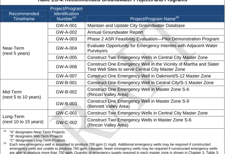
RECOMMENDED GROUNDWATER PROJECTS AND PROGRAMS
ES.9
A number of projects have been recommended in this Groundwater Master Plan to monitor and track groundwater conditions underlying the City and provide for emergency groundwater supplies in the event of a loss of supplies from the Agency during an emergency. These projects are listed in Table ES-4.
Table ES-4. Recommended Groundwater Projects and Programs
Recommended Timeframe
Project/Program Identification
Number(a) Project/Program Name(b)
Near-Term (next 5 years)
GW-A-001 Maintain and Update City Groundwater Database GW-A-002 Annual Groundwater Report
GW-A-003 Phase 2 ASR Feasibility Evaluation—Pilot Demonstration Program GW-A-004 Evaluate Opportunity for Emergency Interties with Adjacent Water
Purveyors
GW-A-005 Construct Two Emergency Wells in Central City Master Zone GW-A-006 Construct One Emergency Well in the Vicinity of Martha and Slater
Test Well Sites to serve Central City Master Zone
GW-A-007 Construct One Emergency Well in Oakmont/S-12 Master Zone
Mid-Term
(next 5 to 10 years)
GW-B-001 Construct One Emergency Well in Central City/S-1 Master Zone GW-B-002 Construct One Emergency Well in Master Zone S-6
(Rincon Valley Area)
GW-B-003 Construct One Emergency Well in Master Zone S-9 (Bennett Valley Area)
Long-Term
(next 10 to 15 years)
GW-C-001 Construct Two Emergency Wells in Central City Master Zone GW-C-002 Construct Two Emergency Wells in Master Zone S-6
(Rincon Valley Area)
(a)
“A” designates Near-Term Projects “B” designates Mid-Term Projects “C” designates Long-Term Projects.
(b)
Each new emergency well is assumed to produce 700 gpm (1 mgd). Additional emergency wells may be required if constructed emergency wells are unable to produce 700 gpm. Likewise, fewer emergency wells may be required if constructed emergency wells are able to produce more than 700 gpm. Quantity of emergency supply required in each master zone is shown in Chapter 3, Table 3-19.
A detailed description of each of these projects is provided in Chapter 7 of this Groundwater Master Plan. As described in Chapter 7, associated with the siting of each new emergency well may be the drilling and evaluation of one or more test wells under the City’s on-going Emergency Test Well Siting Program to identify the best locations for new emergency wells. A recommended timeline for project implementation is provided in Figure ES-2.
BENEFITS TO GROUNDWATER MANAGEMENT
ES.10
The information developed and evaluated in this Groundwater Master Plan, and the recommended policies and projects resulting from these evaluations, provide numerous benefits to the City:
• The information developed will be shared and incorporated into the Santa Rosa Plain Groundwater Management Plan as applicable;
• The monitoring well network will provide additional data for CASGEM and provide for a better understanding of the groundwater basin; and
• The Groundwater Master Plan will provide staff guidance for participation on the Basin Advisory Panel.
0 2,700 5,400 Scale in Feet
FIGURE ES-1
City of Santa Rosa Groundwater Master Plan
OPERATIONAL
MASTER ZONES
& < & < & < & < & < & <&< & < & < & < & < & < & < & < & < & < & < & < U T U T U T U T U T U T U T U T U T U T U T U T U T U T U T U T U T U T U T U T U T U T U T&
Ú[&
Ú[&
Ú[&
Ú[&
Ú[&
Ú[&
Ú[&
Ú[&
Ú[&
Ú[&
Ú[&
Ú[&
Ú[&
Ú[£
¤
101£
¤
101 12 12 From Agency's Russion River-Cotati Intertie Pipeline From Agency's Santa Rosa Aqueduct Peter Springs Carley Farmers Lane LeeteSpring Lake Well
Slater Galvin Madrone Martha Way Doyle Park North Village
Place to Play Park
Northwest Community Park
12 3RD 10 1 E FU LT O N PINER 4TH SA NTA R O SA COLLEGE 9TH B HOEN YULU PA C O FF EY SONOMA LUDWIG C O R BY MONTGO MERY HEARN ST O N Y PO INT STEELE GUERNEVILLE C LE VE LA N D BENNETT VALLEY M E N DO C IN O R AN G E D PETA LUM A H ILL OCCIDENTAL C AL IS TO G A CHANATE W EST W R IG H T JENNINGS M A R LO W OAKM ONT YUBA W AL LA C E LOS A LAMO S RIEBLI 5TH TODD BA IR D ME LITA HOPPER BR U SH C R EEK PE TE R SO N SU M M ER FI EL D M ISSI O N H U M BO LD T D U TT O N SAN MIGUEL 7TH N O RTH FAR MER S BELLEVUE VALLEJ O MONTEC ITO BADGER PACIFIC BRO O KW OO D D O W D OAK LEAF SCENIC BU R BAN K AR M O RY LEO LLANO MAPLE GIFFEN DENNIS HALL PA R KE R H IL L W AL TZ ER BURT NORTHPOINT OL D R EDW OO D ASTON M O O R LA ND PRICE MARSH CHICO 1ST SEBASTOP OL YERBA BUENA CREEKSIDE BETH ARDS BA RN ES A FINLEY FR AN C IS CO STONE BRIDGE R ID LE Y AIR W AY ROBLES TACHEVAH
MARK WEST SPRINGS
PYLE HID DEN VAL LEY BARHAM TALB OT ELLIOTT FRAN KLIN KAWANA SPRINGS W ILS ON RINCON SPENCER YOLANDA SAIN T A ND REW S M ID DL E RIN CO N SA IN T FR AN CIS ST AN D IS H FOO THILL D U TT O N M EA D O W MOUNTAIN VIEW RIDGWAY THO M AS LA KE H AR RIS LEWIS BR IT TAIN BICENTENNIAL VEN TU R A VALL EY O AKS COLGAN FR ES N O SKYF ARM PYTH IAN FOUN TAIN GROV E BRYDEN PARKH URST ROGE RS MO RG AN C O R PO R AT E C EN TE R BO YD CYPRESS W IL JAN CANYON EX ET ER INDUSTRIAL AS H FAIRFIELD WHITE OAK HEARN AV BAKE R AV TODD RD GRIFFEN ALLAN PU TN EY R AILR O AD FRANCES M E R C ED FR ESN O W R IG H T RIEBLI MONT ECIT O ROBLES 101 12 TODD DU TTO N 101 SEBASTOPOL BR IT TAIN BPS S9 BPS S8 BPS S7 BPS S4 BPS S3 BPS S6 BPS S5 BPS S2 BPS S1 BPS S11 BPS S12 BPS S16 BPS S17 BPS S10 R7 2 MG R6 4 MG R4B 2 MG R2A 1 MG R9A 2 MG R9C 1 MG R12B 1 MG R3 0.5 MG R5 0.3 MG R9B 2.5 MG R8 0.75 MG R4A 0.5 MG R2B 1.5 MG R10 0.2 MG R11 1.15 MG R12A 0.5 MG R17 0.75 MG R16 0.25 MG Annadel 2 3 MG R1A, R1B 1.0 MG Annadel 1 2.5 MG Kawana Tanks 20 MG Ralphine Tanks 36 MG LEGEND Supply Source:
&
Ú[ S-1 (PZ R1, R2, R3, R5)&
Ú[ S-4 (PZ R4, R16, R17)&
Ú[ S-6 (PZ R6, R7, R8)&
Ú[ S-9 (PZ R10, R11)&
Ú[ S-12 (PZ R12, R13, R14, R15)Zone with no Emergency Supply
A9 U T City Tanks U T Agency Tanks & < Test Wells & < Municipal Wells &
< Future Test Wells
&
< SCWA Well &
< Private Well
Agency Aqueduct System
City Pipelines
8-inch or smaller diameter 10-inch diameter
12-inch or larger diameter Rodgers Creek Fault
Master Zone Legend:
Master Zone S-1Master Zone S-4 Master Zone S-6 Master Zone S-9 Master Zone S-12
Central City Master Zone Oakmont Master Zone
Construct
Emergency Wells &
Install System
Modifications
• Design/construct 3 new emergency wells:
• Identify and construct 2 emergency wells in Central
City Master Zone (1 emergency well near Master Zone S-1 and 1 emergency well in central/southern portion of Central City Master Zone) (GW-A-005)
• Identify and construct 1 emergency well in
Oakmont/S-12 Master Zone (GW-A-007)
• Construct new emergency well in the vicinity of the
Martha and Slater test sites (GW-A-006)
• Utilities staff to investigate opportunities for emergency
connections with Cal American, City of Rohnert Park and Valley of the Moon (GW-A-004)
• Revisit/revise project prioritization list every five years to reflect actual areas of specific development and/or other changed conditions
• Construct 1 additional emergency well in Central
City/S-1 Master Zone (GW-B-00City/S-1)
• Construct 1 emergency well in Master Zone S-6
(GW-B-002)
• Construct 1 emergency well in Master Zone S-9
(GW-B-003)
• Revisit/revise project prioritization list every five years to reflect actual areas of specific development and/or other changed conditions
• Construct 2 additional emergency wells in Central City
Master Zone (GW-C-001)
• Construct 2 additional emergency wells in Master Zone
S-6 (GW-C-002)
Conservation &
Efficiency;
Water Reuse
Maintain City Groundwater Webpage (add link to new documents as they become available) and
Maintain City Groundwater Database (add groundwater level and water quality data for Key and Supplemental wells; add new test wells; add new emergency wells) (GW-A-001) Review USGS Report Findings and Recommendations; update
City’s GW database with data from USGS Study (when available)
Update City’s Groundwater Master Plan
Update City’s Groundwater Master Plan
Monitoring &
Modeling;
Stakeholder
Involvement & Public
Awareness
Integrated
Groundwater
Management
Continue evaluation of ASR feasibility in specific areas of City (GW-A-003) Adopt City’s GroundwaterMaster Plan
Groundwater
Protection & Recharge
Continue to support the City’s water conservation programs and on-going recycled water program
Implement applicable recommendations of the Salt & Nutrient Management Plan; Pursue actions that result in protection of the City’s groundwater wells from potential contamination by others Collect Semi-Annual Groundwater Elevation Measurements for Key and Supplemental Wells (Spring & Fall)
Submit Groundwater Elevation Data to CASGEM Program (June & December) (coordinated with Sonoma County Water Agency) Prepare Annual Groundwater Report (GW-A-002)