Article
The effect of using chip and slash in reducing sheet
erosion on forest road slopes
Yilmaz Turk 1,*
1 Department of Forest Engineering, Faculty of Forestry, Duzce University, 81620 Duzce, Turkey; [email protected]
* Correspondence: [email protected]; Tel.: +90-533-5474327
Abstract: This study compared the use of chip and slash to minimize the loss of sediment on newly constructed forest road slopes and investigated the annual amount of sediment loss on bare forest road slopes. A runoff block (sample field) was established for each of the four designated test sites (two cutslopes and two fillslopes). Each block had three runoff plots. One of the runoff plots was left empty for the control (CNT), while chip (C) and slash (S), respectively, were deposited in the other two. A total of 108 water samples were taken from the test sites and the amount of their suspended sediment calculated in the laboratory. As a result of this study, it was determined that the amount of soil loss in the control plots was about 1.26 times higher than in the slash plots and 2.21 times higher than in the chip plots. According to the results of variance analysis on the amounts of sediment, a statistically significant difference was found between the suspended sediment quantities transported on the road slopes (P <0.05). However, no statistically significant difference between the suspended sediment quantities transported in the plots and the other variables of aspect, gradient or road slope was revealed by the t-test (P >0.05).
Keywords: road slopes, sheet erosion, chip, slash, rehabilitate, Turkey
1. Introduction
Forest roads are the most important infrastructural facilities for the utilization of renewable natural forest resources. In order to achieve the goal of planning sustainable forestry activities, a road network must be established. Forest roads interact within many technical, economic, and environmental specifications in order to fulfill these tasks [1-2].
Although roads are the first step in the development of forestry resources, they are also infamous for bringing about erosion and sedimentation and for adversely impacting wildlife and water resources, all of which devastate the forests in terms of production and other significant forestry activities. On the other hand, forest road construction may cause some environmental problems if they are not planned by considering required protective measures or not implemented in the field by using suitable techniques. One of the major environmental problems resulting from improper forest road construction is the acceleration of soil erosion. In a forest ecosystem, the fertile topsoil is rich in organic matter which provides bulk density, permeability and erosion-resistance. During the road construction stage, this topsoil is stripped off, altering the surface slope. This changes the structure of the soil as it is exposed and compacted for the construction area. Therefore, soil loss by erosion and surface runoff is accelerated in both cut and fill slope surfaces of forest roads. These effects emerge as the most important factors determining soil loss by erosion [3-6].
Usually the main reason for increased erosion after the construction of forest roads can be listed as the elimination, in part or in whole, of the protective flora along the way [7-9]. In addition, with increased cutslope length there is also an increasing rate of soil loss [10-12]. Moreover, possible causes of the accelerated erosion which may take place following road construction on forested lands include destruction or impairment of the natural soil structure and fertility, increased slope gradients created by construction of cutslopes and fillslopes , decreased infiltration rates on parts of
the road, interception of subsurface flow by the road cut slope, decreased shear strength, increased shear stress, cutslopes and/or fillslopes, and concentration of generated and intercepted water [4, 7].
More than 90% of sediment production originates from forest roads and the greater part of this occurs in excavations and gradient slopes [13-14].
To date, many studies have been conducted related to environmental and ecological effects of forest roads and their surfaces [15-17]. In addition, the losses of sediment in natural and deteriorated areas have been compared. However, studies investigating the effect of the methods used to reduce the surface erosion on the forest road slopes are very limited.
A stable floor is durable and non-degrading and offers protection against erosion during changing weather conditions. In order to minimize surface erosion on forest road slopes, stabilization of the slopes should begin after road construction. The first winter following the construction of the slopes is a critical period for stabilization. During the period before vegetation development, many failures arise due to the slopes. The first failures occur after heavy rains. If they are remedied quickly and effective repair methods are applied, more serious damage can be prevented. For example, great repairs may be required or the road may become unusable. A good maintenance program should be applied until the slopes are fully stabilized. Slope stabilization is expensive; however, when done properly, the costs are met by the fulfilling of their functions [18]. In general, the methods applied against slope erosion can be divided into three types: structural, vegetative and biotechnical. Structural methods include stone arches, dry stone structures, gabions, log crib revetments and timber retaining walls. Among the vegetative methods are living fences, mesh fencing, live bush bundles, branch covers, planting of seedlings, seed spraying, seed planting and ready lawns. Biotechnical methods can include plant walls and wicker covers [4, 11, 18, 19].
The first aim of this study was to compare the use of chip and slash to minimize the loss of sediment on newly constructed forest road slopes (both cut and fill). Secondly, the study aimed to investigate the annual amount of sediment loss on bare forest road slopes and finally, to compare the sediment losses between cut slopes and fill slopes.
2. Materials and Methods
2.1. Study area
The study was carried out in the Aksu district (40° 47’ 08" - 40° 52’ 02" N, 31° 16’ 45" - 31° 26’ 22" E) in the Western Black Sea province of Duzce, Turkey. The altitude in the study area, which has a northern aspect, ranges between 355 and 1365 m a.s.l. The average annual rainfall is 816.7 mm and temperatures range from -0.4 to 28.5 °C, with an annual average during the summer of 24.4 °C. The study area forests are managed as high forests and have mixed stands. Tree species in the mixture include Fagus orientalis Lipsky, Quercus spp. and Carpinus betulus L. The study area covers 5966.5 ha of forest land. Four test sites (two cutslopes and two fillslopes) were determined on a newly constructed road (code no. 038) within the boundaries of the Aksu Forest Enterprise Directorate.
2.2. Forest road
The forest road design was conducted in accordance with Communiqué no. 292 of the General Directorate of Forestry of Turkey. According to this communiqué, forest road construction is carried out by arranging the slope surfaces on both sides of the road platform and road by processing the natural ground with excavators or dozers. Dozers were traditionally used for road construction; however, these days, in compliance with environment protection, excavators are used. Secondary forest roads use a 1:1 ratio in cutslopes, a 3:2 ratio in fillslopes and a 3:1 ratio in 1 m-wide ditches. The surface of fillslopes formed by the excavated material is stabilized by using a 2:3 ratio. The surface of cutslopes is formed by excavating the natural ground, and the surface of the slope formed by the excavated material remains exposed to erosive effects.
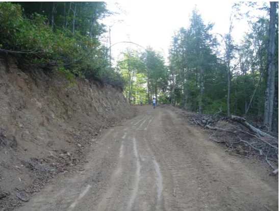
been constructed. Hydraulic excavators were used in the construction of the forest road in the study. The platform of the forest road in the study area is on average 5.26 m wide with an average road slope of 8%. It is a low-volume, secondary forest road constructed without asphalt (Fig. 1).
Figure 1. Forest road in study area. 2.3. Establishment of the runoff plots
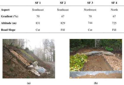
The field work began after the construction of the forest road. A runoff block (sample field) was established for each of the four designated test sites. Two of the blocks (fillslopes) had gradients of 67% and the other two (cutslopes) of 70%. Two of the blocks were planted facing north and the other two facing south (Table 1). Each block had three runoff plots. One of the runoff plots was left empty for the control (CNT), while chip (C) and slash (S), respectively, were deposited in the other two. The chip plots were laid with 12 kg (4 kg m−2) of chips at a thickness of 1 cm. The chips were obtained
from a private workshop in the study area region. In the slash plots, slash (branch/leaf) logging residues obtained from the test area was placed so as to cover the whole of the plot (1.5 kg m−2). The 1
× 3 m plots were established with the long sides parallel to the direction of the slope. The sides and upper edges of the plots were constrained by 20 cm-wide metal sheets, buried in the soil to a depth of 10 cm. The joints of the sheets were suitably connected and sealed with silicone to prevent leakage of water at the sides. An inlaid structure was formed by inserting a plastic nylon layer at the bottom edge and the runoff water was deposited in a collection tank (Fig. 2). The runoff water was measured by scale cylinders in the collection vessel and converted to mm units according to the plot area of 3 m2 [20].
Table 1. General information related to the study area.
(a) (b)
Figure 2. Establishment of runoff plots on road slopes: (a) Cutslopes (left, chip; center, control; right, slash); (b) Fillslopes (left, slash; center, control; right, chip).
2.4. Water sample collection and laboratory analysis
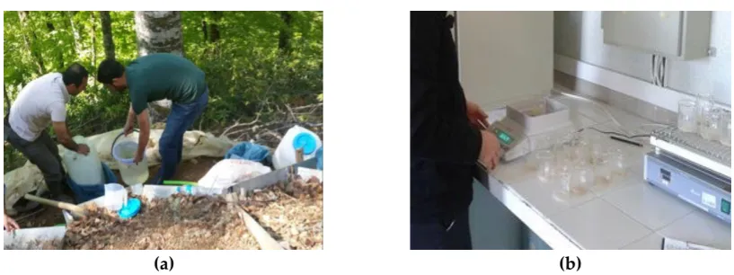
The runoff passing through the soil after a rainfall which accumulated in the collection tank was measured using scale cylinders and the amount recorded. During the study, the runoff measurements were recorded repeatedly after each rain. The amount of runoff occurring after prolonged and heavy rainfall was measured on the same day or the next day. In this way the risk of exceeding the capacity of the storage tanks was prevented. When rainfall was not long-term or severe, monthly measurements were taken. Nine measurements were taken from the study area throughout the period of October 2014‒March 2016. A total of 108 water samples were collected from the test sites, 36 each from the control, chip and slash plots. After the measurement and recording process was completed, the runoff in the storage tanks was completely drained.
In order to determine the amount of suspended sediment for each plot, a 0.5 L sample of water taken from the runoff storage tank was brought to the laboratory and put into the ash furnace. After the runoff water was evaporated, the samples of residual suspended sediment were weighed on a precision scale. The specified value was calculated according to the total runoff amount accumulated in the storage tank and the total suspended sediment it carried (Fig. 3). The materials coming from the slash plot collecting areas were trapped in a sieve in the collection tank and were not used in determining the amount of suspended sediment [21-22].
SF 1 SF 2 SF 3 SF 4
Aspect Southeast Southeast Northwest North
Gradient (%) 70 67 70 67
Altitude (m) 831 829 744 725
(a) (b) Figure 3.(a) Water sample collection; (b) Water sample analysis at the laboratory.
2.5. Statistical analyses
The Kolmogorov-Smirnov test was used to determine whether or not the data were normally distributed. As the data did not show a normal distribution, normal distributions were provided by applying the square root transformation. Variance analysis was used to detect any difference in the amounts of sediment and runoff among the plots in the experimental sites. The Independent Samples t-Test was applied to find differences among the plots in the factors of aspect, gradient and road slope (cut and fill). All statistical analyses were performed using the SPSS 22 package program.
3. Results and Discussion
3.1. Amount of runoff and suspended sediment
Measurements during the period of October 2014‒March 2016 were assessed by taking the nine plot measurements. The average runoff rates in the test site plots were 2.02 mm/m2 in the control
plots, 2.00 mm/m2 in the slash plots and 1.94 mm/m2 in the chip plots.
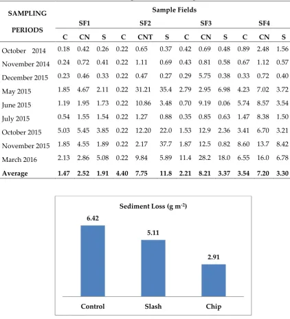
In the period covering runoff from the plots, the total sediment transported and the amounts of suspended sediment transported from the sample field plots are given in Table 2. The amount of sediment was found to be 6.42 g m-2 in the control plots, 5.11 g m-2 in the slash plots and 2.91 g m-2 in
the chip plots. An average of 35.29 g m-2 year-1 of soil loss was found in the control plots.
Studies performed on forest road cutslopes in different regions determined the amount of sediment loss in cutslopes to range from 0.5-37 kg m-2 yr-1 [23-29]. The values obtained in the present
study were lower than those in other studies. In some studies, when the amount of sediment loss in cutslopes and fillslopes was compared, more losses were found in the cut slopes [30-32, 12]. However, it has been reported that 60% of the sediments from roads are caused by fillslopes, 25% by the road surface and 15% by cutslopes. In this study, the amount of sediment loss was found to be higher in the fillslopes [14].
3.2. Plot comparison results
According to the results of a total of 108 water samples taken to determine the soil loss from the plots in the test sites, the average amount of soil loss was measured as 6.42 g m-2 in the control plots,
5.11 g m-2 in the slash plots and 2.91 g m-2 in the chip plots. In other words, it was determined that the
Table 2. Amount of suspended sediment in sample fields.
Figure 5. Soil loss in the test plots.
One study indicated that a mulch as well as seed and fertilizer should be placed on roadside slopes if soil erosion is to be minimized during the first rainy season following road construction [14]. Furthermore, bare, unprotected roadside slopes continued to erode at a rather constant rate throughout the course of the study. The loss amounted to about 0.51 cm of soil per year. Another study pointed out that road segments where vegetation was cleared from the cutslope and ditch produced about seven times as much sediment as road segments where vegetation was retained, showing the potential reduction in erosion by revegetation following construction and the potential impact of ditch cleaning during maintenance [33].
According to the results of variance analysis on the sediment amounts, a statistically significant difference was found between the suspended sediment quantities transported in the plots (P <0.05). Suspended sediments transported in the control plots were the highest (1.409), while the lowest (1.136) were transported in the chip plots, with the transported slash plot amount falling between
6.42
5.11
2.91
Control Slash Chip
Sediment Loss (g m-2)
Amount of Suspended Sediment ( g m-2)
SAMPLING
PERIODS
Sample Fields
SF1 SF2 SF3 SF4
C CN
T
S C CNT S C CN
T
S C CN
T S
October 2014 0.18 0.42 0.26 0.22 0.65 0.37 0.42 0.69 0.48 0.89 2.48 1.56
November 2014 0.24 0.72 0.41 0.22 1.11 0.69 0.43 0.81 0.58 0.67 1.12 0.57
December 2015 0.23 0.46 0.33 0.22 0.47 0.27 0.29 5.75 0.38 0.33 0.72 0.40
May 2015 1.85 4.67 2.11 0.22 31.21 35.4 2
2.79 2.95 6.98 4.23 7.02 3.72
June 2015 1.19 1.95 1.73 0.22 10.86 3.48 0.70 9.19 0.06 5.74 8.57 3.54
July 2015 0.54 1.55 1.54 0.22 1.27 0.88 0.35 0.85 0.63 1.47 8.38 1.50
October 2015 5.03 5.45 3.85 0.22 12.20 22.0 5
1.53 12.9
4
2.36 3.41 6.70 3.21
November 2015 1.85 4.55 1.89 0.22 2.17 37.7 3
1.87 12.5
2
0.82 8.60 13.7
9
8.42
March 2016 2.13 2.86 5.08 0.22 9.84 5.89 11.4 8
28.2
3
18.0
3
6.55 16.0
7
6.78
Average 1.47 2.52 1.91 4.40 7.75 11.8
6
them (1.229). According to the results of variance analysis on the mean runoff rates, no statistically significant difference was found between the runoff quantities in the plots (P >0.05) (Table 3).
Table 3. Variance analysis results for transported suspended sediment. Parameters Plots Number of
Samples
Average Standard Error
P *
Suspended Sediment
CNT 36 1.409 a 0.074
0.029
C 36 0.136 b 0. 062
S 36 1.229 ab 0.081
Runoff
CNT 36 1.288 a 0.102 0.994
C 36 1.274 a 0.095
S 36 1.286 a 0.100
* P <0.05.
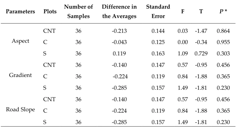
The difference between the suspended sediment quantities transported in the plots and the other variables was revealed by the t-test. There was no statistically significant difference among the suspended sediment quantities in the plots according to aspect (north or south), gradient or road slope (cut or fill) (P >0.05) (Table 4).
Table 4. Results of t -test for other parameters in plots with transported suspended sediment.
Parameters Plots Number of Samples
Difference in
the Averages
Standard
Error F T P *
Aspect
CNT 36 -0.213 0.144 0.03
0
-1.47
4
0.864
C 36 -0.043 0.125 0.00
3
-0.34
5
0.955
S 36 0.119 0.163 1.09
2
0.729 0.303
Gradient
CNT 36 -0.140 0.147 0.57
0
-0.95
2
0.456
C 36 -0.224 0.119 0.84
4
-1.88
4
0.365
S 36 -0.285 0.157 1.49
7
-1.81
2
0.230
Road Slope
CNT 36 -0.140 0.147 0.57
0
-0.95
2
0.456
C 36 -0.224 0.119 0.84
4
-1.88
4
0.365
S 36 -0.285 0.157 1.49
7
-1.81
2
0.230 * P <0.05.
4. Conclusions
In this study, sediment loss due to sheet erosion occurring on the forest road slopes was investigated and the use of chips and slash to minimize soil loss was compared. As a result of this study, it was determined that the amount of soil loss in the control plots was about 1.26 times higher than in the slash plots and 2.21 times higher than in the chip plots. In this study, in order to minimize the loss of sediment in slopes, chip application was shown to be better than slash.
fell between them (1.229). However, no statistically significant difference between the suspended sediment quantities transported in the plots and the other variables of aspect (north or south), gradient or road slope (cut or fill) was revealed by the t-test (P >0.05).
With this study it has become clear that logging residues (chip and slash) can be used to reduce the sheet erosion that occurs on the road slopes after the construction of forest roads. Apart from the use of logging residues, other slope stabilization methods should be compared to determine the best method.
Acknowledgments: This study was carried out with the support of Düzce University. The physical analyses were done in the laboratories of the Faculty of Forestry. We give special thanks to the Aksu Forest Enterprise Directorate for their permission and help. Special thanks are extended to Nuriye Peaci for English editing. Conflict of Interest: The authors declare no conflict of interest. The founding sponsors had no role in the design of the study, in the collection, analyses, or interpretation of data, in the writing of the manuscript, or in the decision to publish the results.
References
1. Erdas, O.. Forest Roads-Vol. I; Karadeniz Technical University, Faculty of Forestry, 187/25: Trabzon, Turkey, 1997.
2. Gumus, S. An Evaluation of Stakeholder Perception Differences in Forest Road Assessment Factors Using the Analytic Hierarchy Process (AHP). Forests 2017, 8 (5), 165, 1-9, 10.3390/f8050165. Available online: https://doi.org/10.3390/f8050165 (accessed on 10 March 2018).
3. Potocnik, I. The multiple use of forest roads and their classification. In: Food and Agriculture Organization of United Nations. In Proceedings of the Seminar on Environmentally Sound Forest Roads and Wood Transport; Sinaia, Romania, June 1996, 17-22.
4. Gorcelioglu, E. Forest Paths-Erosion Relations. Istanbul University Faculty of Forestry Publication No: 476; Istanbul, Turkey, 2004.
5. Aruga, K.; Sessions, J.; Akay, A.E. Heuristic planning techniques applied to forest road profiles. J. Forest Res. 2005, 10, 83–92, 10.1007/s10310-004-0100-4. Available online: https://doi.org/10.1007/s10310-004-0100-4 (accessed on 15 May 2017).
6. Bjorklund, E.S. Environmental Statement 2005. Wood Supply Europe Report, Stora Enso Forest Product, Sweden, 2006.
7. Megahan, W. F. Reducing erosional impacts of roads. FAO Conservation Guide 1, FAO, Rome, Italy, 1977. 8. Jordan, A.; Martinez-Zavala, L. Soil loss and runoff rates on unpaved forest roads in southern Spain after
simulated rainfall. Forest Ecol. Manag. 2008, 255 (3), 10.1016/j.foreco.2007.10.002. Available online: https://doi.org/10.1016/j.foreco.2007.10.002 (accessed on 16 June 2016).
9. Zemke, J.J. Runoff and soil erosion assessment on forest roads using a small scale rainfall simulator.
Hydrology 2016, 3, 25, 10.3390/hydrology3030025. Available online:
https://doi.org/10.3390/hydrology3030025 (accessed on 16 February 2017).
10. Luce, C.H.; Black, A.T. Sediment production from forest roads in western Oregon. Water Resour. Res. 1999, 35 (8), 2561-2570.
11. Nasiri, M.; Hosseini, S.A. Effect of LS factor on soil loss rate from cut slopes after the construction of forest roads. J. Environ. Sci. Manag. 2012, 15 (2), 13-18, 10.1007/s40515-015-0024-9. Available online: https://doi.org/10.1007/s40515-015-0024-9 (accessed on 20 May 2016).
12. Hacisalihoğlu, S.; Gumus, S.; Kezik, U.; Karadag, H. Impact of Forest Road Construction on Topsoil Erosion and Hydro-Physical Soil Properties in a Semi-Arid Mountainous Ecosystem in Turkey. Pol. J. Environ. Stud. 2019, 28 (1), 1-9, 10.15244/pjoes/81615. Available online: https://doi.org/10.15244/pjoes/81615 (accessed on 15 September 2018).
13. Elliot, W.J.; Koler, T.E.; Cloyd, J.C.; Philbin, M. Impact of Landslides on an Ecosystem. Presented at the 1994 - ASAE International Winter Meeting in Atlanta, GA, USA. ASAE, St. Joseph, MI, USA, 1994; ASAE Paper No: 94-7517.
14. Grace, J.M.; Rummer, B.; Stokes, B.J.; Wilhoit, J. Evaluation of Erosion Control Techniques on Forest Roads. ASAE 1998, 41 (2), 383-391.
16. Safari, A.; Kavian, A.; Parsakhoo, A. Assessment of effect of road or road construction on soil physical and chemical properties in northern forests of Iran. IJABBR 2013, 1 (8), 835-850.
17. Zemke, J.J.; König, D. Abflussbildung und bodenerosion auf forstwegen. Geogr. Rundsch. 2016, 68, 46. 18. Peker, T. Morphological problems encountered in highways and measures to be taken in terms of
landscape architecture in Turkey. Master’s Thesis, Ankara University, Institute of Science and Technology, Ankara, Turkey, 1988.
19. Çelem, H. Plantation technique of problem areas (vegetative coverings). Ankara University, Faculty of Agriculture Publication No: 1047, Ankara, Turkey, 1988.
20. Zengin, M. Comparison of Forest Ecosystems in Kocaeli Region in Terms of Hydrological Afforestation. Ministry of Forestry Poplar and Rapidly Developing Species of Forest Trees Research Institute Technical Bulletin No. 182. Ministry of Forestry Publication No. 055, Directorate Publication No. 217, İzmit, Turkey, 1997.
21. Şensoy, H.; Kara, D. Determination of surface flow and suspended sediment of two different lengths of slope using the parcel method. Artvin Coruh University Forest Faculty Journal 2013, 14(2), 216-224.
22. Turk, Y.; Yildiz, M. Use of branches and branch leaves in repairing loss of plant nutrient elements in skidding trails. Düzce University Science and Technology Journal 2018, 6 (4), 941-952.
23. Wilson, R.L. Source of erosion on newly constructed logging roads in the H.J. Andrews’s experimental forest. Bureau of Land Management (unpublished report). University of Washington, Seattle, WA, USA, 1963.
24. Dyrness, C.T. Grass-legume mixtures for erosion control along forest roads in western Oregon. J. Soil Water Conserv. 1975, 30, 169-173.
25. Megahan, W.F. Erosion from roadcuts in granitic slopes of the Idaho batholith. In Proceedings Cordilleran section of the Geological Society of America, 76th Annual Meeting, Oregon State University, Corvallis, Oregon, USA, 1980, p. 120.
26. Kartaloglu, M. Temporal variation of sedimentation on paved and unpaved forest roads (unpublished M.Sc. Thesis), Istanbul University, Science Institute, Istanbul, Turkey, 2011, p. 113.
27. Demir, M.; Makineci, E.; Kartaloğlu, M. Temporal sediment production of paved and unpaved forest roads. Fresen. Environ. Bull. 2012, 21, 1180-1185.
28. Demir, M.; Makineci, E.; Kartaloğlu, M. Monitoring of grain size fractions of sediments from different forest road types. J. Environ. Prot. Ecol. 2013, 14, 1559-1568.
29. Erdem, R.; Enez, K.; Demir, M.; Sariyildiz, T. Slope Effect on the Sediment Production of Forest Roads In Kastamonu of Turkey. Fresen. Environ. Bull. 2018, 27(4), 2019-2025.
30. Sidle, R.C.; Sasaki, S.; Otsuki, M.; Noguchi, S.; Nik, A.R. Sediment pathways in a tropical forest: Effects of logging roads and skid trails. Hydrol. Process. 2004, 18, 703–720, 10.1002/hyp.1364. Available online: https://doi.org/10.1002/hyp.1364 (accessed on 12 March 2016).
31. Arna´eza, J.; Larreab, V.; Ortigosa, L. Surface runoff and soil erosion on unpaved forest roads from rainfall simulation tests in northeastern Spain. Catena 2004, 57, 1-14, 10.1016/j.catena.2003.09.002. Available online: https://doi.org/10.1016/j.catena.2003.09.002 (accessed on 15 March 2016).
32. Jordan, A.;, Martinez-Zavala L. Soil loss and runoff rates on unpaved forest roads in southern Spain after simulated rainfall. Forest Ecol. Manag. 2008, 255 (3), 913-919, 10.1016/j.foreco.2007.10.002. Available online: https://doi.org/10.1016/j.foreco.2007.10.002 (accessed on 18 March 2016).
33. Luce, C.A.; Black, T.A. Sediment production from forest roads in western Oregon. Water Resour. Res. 1999, 35 (8), 2561–2570, 913-919, 10.1029/1999WR900135. Available online: https://doi.org/10.1029/1999WR900135 (accessed on 05 March 2016).