Implementation Of Fast And Real Urban Road
Extraction And Semi Automation Using
Nn-Sparsity Adaptive Multi Feature Technique
SRUNGARAPU SREEVANI , Dr. S. NAGARAJA RAOAbstract: In this research high resolution urban images from satellite has been collected and gives the automatic road extraction and tracking solution. The satellite which are collected from database contains noise and occlusions, because of this a perfect road tracking does not possible. Various high resolution urban image implementations did not remove several problems like multi-layer extraction, multi spectral noise. The existed methods does gives the low accuracy and throughput. In this investigation proposed an NN(neural networks) based adaptive multi feature(NN-AMF) model. This model gives the more accuracy and PSNR, CC.
Index Terms: NN-AMF-(neural network sparsity model), High-Resolution, Multi feature, Urban images.
————————————————————
1
INTRODUCTION
Suppositions on a geometric-stochastic street exemplary are unmistakably recorded as pursues.
1) Road breadth difference is little also street thickness alteration is probably going to exist moderate.
2) Road course variations be present probably going to remain moderate.
3) Street neighbourhood normal dim dimension is probably going to differ just gradually.
4) Grey dimension variety among street and foundation is probably going to be huge.
5) Roads are probably not going to be short.
Anyway they are not in every case valid, as street pictures differ a ton with ground goals, street type, and thickness of encompassing items, etc. A particular street model just as a street removal technique is essential on behalf of extricating street outlines utilizing high-goals satellite picture, for example street and HR pictures, where a street model is desirable over have as less yet conventional suppositions as possible[1-2]. In this work, we propose a self-loader technique for street withdrawal starting urban/rural scene utilizing towering-goals satellite pictures, Which contain a pounded goals of around 1 meter, also 4 groups, for example red, green, blue, in addition to close ultraviolet. The technique comprises of 3 stages as appeared in Figure 1. A "street veil" is characterized in this examination as a cover of street pixels, which are produced through arranging street pixels of a multi-range cable picture utilizing business accessible detecting software [3-4]. A "Street Seed" is characterized in this exploration as a indicator point, demonstrating that a street is going concluded the point beside the course. Street nodes be located extricated by following edge pixels, as a extended edge mark through just a moderate alter of course recommend a street or waterway going finished.
Street streaks be present extricated in a self-loader method, where assumed a beginning stage, a street stripe is followed by iteratively coordinating a street layout through mutually street veil in addition to street seeds, regulator focuses Demonstrating the correct headings are relegated through administrator if the street line became gone.
FIGURE: 1 ROAD EXTRACTION FLOW
1. EXISTEDWORK
In the accompanying work, we address each progression in detail. Trials are led utilizing a street pictures close-by Delhi City, India. Exploratory outcomes and discourses are given accordingly, where street extraction and guide age are contemplated in detail at both thick structure territory and field. A pixel-based street cover is separated utilizing business remote detecting programming Matlab. Given the preparation estimations of undergrowth, soil, construction (solid), liquid, prompt expressway, Principle Street as well as little street, picture pixels of a multi-range satellite broadcasting picture are arranged hooked on various gatherings utilizing greatest probability technique. As the multi-range d-sat picture utilized in this exploration has IV groups, for example red, green, also blue in addition to close infrared, characterization outcome is significantly additional dependable than individuals on 3 groups, for example red, green as well as blue, or fewer. ____________________________________
SRUNGARAPU SREEVANI ,M.tech scholar E.C.E Department G.Pulla Reddy engineering college (Autonomous), Kurnool, A.P, India. [email protected]
6932 Picture pixels named direct roadway, fundamental street also
little street be situated misused in this exploration to create a "street mask"[5-6]. A "street cover" is a twofold picture, where silvery pixel recommends to facilitate a street like article is greatest presumably finished yonder. The street cover is abused in street line mining [7-9].
FIGURE: 2 EXTRACTING ROAD SEED
Edge pixels extricated by semantic channel reflect not just the limits of streets, structures, streams, or shadows, yet in addition some other neighbourhood fast changes of photometric attributes. Albeit particularly in focal urban, authority pixels of structures, vegetation in addition to shadows be located blended through that of streets, so street limits be present not as pure as to be extricated, a extended superiority stripe through just a moderate alter in course prepare emphatically recommend the limit of a street otherwise a waterway. Along these lines, they remain situated removed in this exploration as "street seed" (see Figure-3), also abused as the admiring data of "street veil" in street line withdrawal [10-11] Applying seman channel on satellite broadcasting picture consequences in a paired picture of control pixels, where boundaries are diminished to a width of solitary pixel. Withdrawal of lengthy superiority positions commencing the twofold picture of edge pixels is directed in 2 stages, following also jointing superiority stripe patches. Street kernels are produced for every edge pixels on the superiority line covers, where 2 headings of the street seed, showing II different conducts of the street track, be situated determined utilizing the extraneous line of the edge line fix at the edge pixel. In this exploration, street lines are removed in a self-loader path by coordinating a street format with both street cover (M) also street seeds-(S). The progression of street line withdrawal is appeared in Fig...-2. Toward the starting, a beginning stage is indicated through the administrator. A street line is reached out commencing the beginning stage in an respective manner, anywhere in every cycle, a quadrilateral street layout (‗T‘) of a characterized breadth (B) and distance (d) is turned at 1 of the fatal purpose of the street stripe & coordinated by the incorporated picture of street cover & street stone to locate the following street stripe opinion (Fig.3). The method breaks while coordinating outcome decreases to
a dimension lower than a give limit. Now, the administrator looks at whether the street line is right, or raced to a misguided course or misfortune its way in a nearby greatest. A control point is doled out at whatever point fundamental by the administrator to direct the street line extraction.
FIGURE: 3 SEMI-AUTOMATIC ROAD LINE EXTRACTIONS
In this examination, coordinating expense of the street format at a picture point p with a turn edge α is characterized as pursues [12].
FIGURE: 4 FLOW OF GUIDING A ROAD LINE TRACING
Given a steering switch opinion q, the street line is altered and further reached out as appeared previously. The separation from any street direct k p toward q is determined as pursues. Expanding street stroke after q is directed similarly as tended to in past area, while following the street line from p to q is diverse at the accompanying binary residences [13].
1) Every cycle, the extensional bearing of street incurable point pk ‗allotted by pk q‘
2) Corresponding expense of street format at a picture opinion ‗p‘ with a turn edge an characterized equally pursues.
REPRESENTATION)
The essential guideline of meagre portrayal is that sign ‗x‘ contain spoken to as a straight mix of a couple of premise courses in gathered collection D by upgrading the l1-regularised least squares issue However, street extraction isn't simply an issue of remaking. The educated target library limits the remaking blunder for the meager portrayal, at the same time, more significantly, it requires a solid discriminative capacity to isolate the street focus from the foundation. Luckily, a straightforward however powerful coding plan called area obliged direct codes had been presented [14], which processes the portrayal with the nearby format covers (premise) in ‗D‘ that are like the applicant test ‗x‘.
Where o indicates component insightful duplication, λ controls the sparsity, and d is the Euclidean separation vector among x and the premise vectors in D. Moreover, a word reference learning strategy called the K-closest neighbor technique is acquainted with point of confinement the space traversed by straightforwardly choosing the K information vectors from the informational index [11].
3.1 MULTIFEATURESPARSEMODEL
The contrast between a street target and a general following target lies in the way that not exclusively does the street target not have rich surface and shading data, however, it is likewise deficient with regards to an unmistakable and stable profile. We characterize α∗ as the arrangement of (2) and x∗ I , I = 1:N, as the inadequate portrayal of the picture patches focused at pixel position ci inside the hopeful window focused at y. The street target appearance is portrayed by the joint sparsity-based histogram circulation of the shading, neighbourhood entropy, and HSC highlights.
a) Colour Feature:
It has been demonstrated that shading data is strong to pivot, bending, and incomplete impediment [15]. The shading histogram can be processed as
Where CI is a standardization steady, h is the data transmission parameter, K() is the piece work, and b(•) is the capacity to figure which canister pixel x∗ I (ci ) is in. Native ‗Entropy‘ Article: ‗Local entropy‘ data is an alluring supplement to shading data on account of variations in enlightenment and foundation mess. The district entropy histogram container be processed below
HSC Feature: The HSC depends on basic attributes [16]. Contrasted and highlights that are bound to change, for example, the angle and the surface, the HSC is progressively hearty for a street focus on that is defenceless to surface items. The HSC can be figured as
FIG. 5.PER-PIXEL REACTIONS OF HIGHLIGHTS, WEIGHTED BY HISTOGRAM ESTEEM.(AN)DUPLICATE.(B)COLOR INCLUDE.(C)
LOCAL ENTROPY HIGHLIGHT.(D)H.S.C INCLUDE
Where CS is a standardization steady and α∗ I j is e jth meagre coeff of the Ith picture fix. In Fig.1, imagine three highlights utilizing the overwhelming loads in every pixel. Plainly, the circulation of the loads of each component differs along the street surface and its region.
FIGURE: 6 PROPOSED WORK
Consequently, using the correlative attributes of the 3 unique highlights enables us to complete street target acknowledgement.
1) Initialization: human administrator is expected to acquire the beginning stage, the course, & the width of the street via naming stone emphases on the information picture.
2) Wordlist Exercise: word reference ‗D‘ is found out by the preparation tests by the K-closest ‗neighbour‘ strategy.
6934 are acquired by the projected multi-highlight
inadequate classical.
4) Future Mass Calculation: To gauge the capacity of every component to recognize a contrast amongst the street goal and foundation, we initially make L target perceptions (close to the street target) and B foundation perceptions (along the vertical street course). The discriminative presentation of each element would then be able to be evaluated by the Fisher separate paradigm [16].
3.2 NN-NEURAL NETWORKS
From a numerical perspective, explore on the guess abilities of feed forward neural systems has focussed on 2 angles: all comprehensive estimation on smaller info circles and estimate in a incomplete set. Numerous scientists consume examined the all complete deduction abilities of normal multi-layer feedstuff ‗NEURAL-NETWORKS‘ [1], [2], [3]. In honest applications, the N-systems are prepared in incomplete making set. For capacity supposition in a restricted making usual, Huang and Babri[4] demonstrates that a sigle-shrouded layer feed forward neural system (S.L.F.N) with at record n concealed neurons and with practically some non-linear enactment competence can learn N particular perceptions with zero blunder. It ought to be noticed that the info loads (linking the material coating to the primary shrouded layer) would be stable in all these past imaginary study roles just as in practically all viable education intentions of feed frontward NEURAL systems. After the info loads and the covered sheet inclinations are elect self assertively, SLFNs tin be principally careful as a straight framework and the yield loads (connecting the concealed layer to the yield layer) of SLFNs container be rationally obvious finished frank gathered up opposite task of the shrouded layer yield networks. In light of this idea, this paper proposes a basic learning calculation for SLFNs called extraordinary learning machine (ELM) whose learning pace can be a large number of times quicker than customary feed forward arrange learning calculations like back-engendering calculation while getting better speculation execution. Unique in relation to customary learning calculations the proposed learning calculation not just will in general achieve the littlest preparing mistake yet additionally the littlest standard of loads. Bartlett's hypothesis on the speculation execution of feed forward neural networks[9] states that for feed forward neural systems achieving littler preparing blunder, the littler the standard of loads is, the better speculation execution the systems will in general have. Along these lines, the proposed learning calculation will in general have better speculation execution for feed forward neural systems.
3.
RESULTS
In our analyses, two informational indexes are applied to assess the presentation of the future practise. The primary informational index, as appeared in ‗Fig.3‘, remained gathered by the GF_2 settlement on the zone of Delhi, India, with a goals of 0.80 M/PIXEL. This picture, with a size of 4000.0×3500.0 ‗pixels‘, incorporates various kinds of clamors, for example, impediment of automobiles, drooping plants,& structure shadows. The 2nd informational index, as appeared in Fig.5., was gathered by the proposed satellite image on the zone of Delhi China, with a 0.60-m goals band. This picture, with a size of 1600.0X1200.0 pixels, incorporates an
assortment of street settings, for example, street factual alteration, impediment of vehicles, as well as a strident bend in the highway.
FIGURE: 7 GRAPHICAL ANALYSES
FIGURE:8 SATELLITE IMAGE
FIG.7&8 this image is observed from data base which is sent by satellite, image contains no information but we need to reduce noise and get information from this obtained image.
Fig.9 shows that histogram equalization of image and this contains resolution and pixel intensity and blurring brightness all we have to reduce and increases this properties.
FIGURE: 10 RGB MODEL
Fig.10 explains about red green, red, blue model of our selected image this image gives more information for future extraction.
FIGURE: 11 GRAPHICAL COMPARISONS
Fig.11 explains that comparison of three methods final one got no errors compared to remaining
FIGURE: 12 FILTER METHODS ON IMAGE
Fig.12 shows different filter methods on image
Enter a number: case1 :kim method case2 : miao method case: 3 proposed method3
Number of seed points=51 Total road lengtgh pixel=33239 completeness=96.61
RMSE(PIXELS=2.25
FIGURE: 13 PROPOSED OUTPUT
Fig.13 shows that final full information image in this image all information is available like a perfect image this is possible with NN-sparse model
TABLE: 1 COMPARISON OF WORK Methods Kim et al Miao et
al Proposed
Number of seed points 57 48 51
Total road length (pixels) 33131 33922 33239 Completeness (%) 93.58 96.51 96.61
RMSE (pixels) 3.34 3.77 2.25
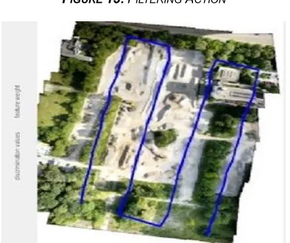
6936 FIGURE 15: FILTERING ACTION
FIGURE 16: FINAL NN-AMF OUTPUT.
Figure 14-16 explains that the implementation step outputs which are acquired from neural network block. In this filtering grey scale adjustment has been done. From step 1 to step4 the image road extraction and classification as shown in above figures.
4.
CONCLUSION
:In this research work high resolution satellite image extraction and semi automation has been performed with the help of neural networks the classification and extraction is done perfectly. Using this NN-AMF model achieves completeness is 96.61% and RMSE has improved by 2.25%. These are the accurate results with this urban image road extraction and semi automation has performed. In this state of art different existed methods are compared with proposed NN-AMF method and conclude that proposed method has good improvement. In this circumstance various problems of urban satellite image extraction and corresponding classification is done with perfect solution.
REFERENCES
[1]. W. Shi, Z. Miao, and J. Debayle, ―An integrated method for urban mainroadcenterline extraction from optical remotely sensed imagery,‖ IEEE Trans. Geosci. Remote Sens., vol. 52, no. 6, pp. 3359–3372, Jun. 2014.
[2]. B. Liu, J. Huang, L. Yang, and C. Kulikowsk, ―Robust tracking using local sparse appearance model and
k-selection,‖ in Proc. IEEE CVPR, Sep. 2011, pp. 1313– 1320.
[3]. Y. He, M. Li, J. Zhang, and J. Yao, ―Infrared target tracking based on robust low-rank sparse learning,‖ IEEE Geosci. Remote Sens. Lett, vol. 13, no. 2, pp. 232–236, Sep. 2016.
[4]. G. Cheng, Y. Wang, F. Zhu, and C. Pan, ―Road extraction via adaptive graph cuts with multiple features,‖ in Proc. ICIP, 2014, pp. 3962–3966.
[5]. J. Wang, J. Yang, K. Yu, F. Lv, T. Huang, and Y. Gong, ―Localityconstrained linear coding for image classification,‖ in Proc. IEEE CVPR, Apr. 2010, pp. 3360–3367.
[6]. Y. Mingfeng, B. Yuming, Z. Gaopeng, and Z. Weijun, ―Adaptive blockfusion multiple feature tracking in a particle filter framework,‖ in Proc. IEEE 3rd Annu. Int. Conf. Cyber Technol. Autom. Control Intell. Syst. (CYBER), Sep. 2013, pp. 400–404.
[7]. X. Ren and D. Ramanan, ―Histograms of sparse codes for object detection,‖ in Proc. IEEE CVPR, Apr. 2013, pp. 3246–3253.
[8]. J. B. Mena, ―State of the art on automatic road extraction for GIS update: A novel classification,‖ Pattern Recognit. Lett., vol. 24, no. 16, pp. 3037– 3058, 2003.
[9]. X. Lin, J. Zhang, Z. Liu, J. Shen, and M. Duan, ―Semi-automatic extraction of road networks by least squares interlaced template matching in urban areas,‖ Int. J. Remote Sens., vol. 32, no. 17, pp. 4943–4959, 2011.
[10]. Y. Zang, C. Wang, Y. Yu, L. Luo, K. Yang, and J. Li, ―Joint enhancing filtering for road network extraction,‖ IEEE Trans. Geosci. Remote Sens., vol. 55, no. 3, pp. 1511–1525, Sep. 2016.
[11]. Y. Zang, C. Wang, L. Cao, Y. Yu, and J. Li, ―Road network extraction via aperiodic directional structure measurement,‖ IEEE Trans. Geosci. Remote Sens., vol. 54, no. 6, pp. 3322–3335, Jun. 2016.
[12]. J. Zhou, W. F. Bischof, and T. Caelli, ―Road tracking in aerial images based on human–computer interaction and Bayesian filtering,‖ ISPRS J. Photogram. Remote Sens., vol. 61, no. 2, pp. 108–124, 2006.
[13]. X. Hu, Z. Zhang, C. Vincent, and C. V. Tao, ―A robust method for semi-automatic extraction of road centerlines using a piecewise parabolic model and least square template matching,‖ Photogram. Eng. Remote Sens., vol. 70, no. 12, pp. 1393–1398, 2004. [14]. T. Kim, S.-R. Park, M.-G. Kim, S. Jeong, and K.-O.
Kim, ―Tracking road centerlines from high resolution remote sensing images by least squares correlation matching,‖ Photogram. Eng. Remote Sens., vol. 70, no. 12, pp. 1417–1422, 2004.
[15]. Z. Miao, B. Wang, W. Shi, and H. Zhang, ―A semi-automatic method for road centerline extraction from VHR images,‖ IEEE Geosci. Remote Sens. Lett., vol. 11, no. 11, pp. 1856–1860, Nov. 2014.