IJSRSET1626136 | Received : 14 Dec. 2016 | Accepted : 31 Dec. 2016 | November-December-2016 [(2) 6: 607-617]
© 2016 IJSRSET | Volume 1 | Issue 12 | Print ISSN : 2395-1990 | Online ISSN : 2394-4099 Themed Section: Engineering and Technology
607
Hydraulic Evaluation of River Restoration Using Numerical
Modelling Approach
Hossam El Sersawy
1, Zeinab El Barbary
21,2 Associate Professor, Nile Research Institute (NRI), National Water Research Center (NWRC), EL-Qanater, P.O. Box 13621, Egypt
ABSTRACT
It is well recognized that urbanization strongly impacts on the Nile River characteristics. The Nile River has experienced major morphological changes during the past decades. Unplanned human interventions and their activities change the connections between the river channel and its adjacent floodplain as shown at Al Wasta City waterfront which located on the west bank of the Nile River, about 81.50 kilometers south of Cairo, Egypt. The study reach suffered from decreased morphological and ecological diversities resulting from human interventions. The major thrust of this research is the proposition of a new strategic plan for river restoration based on quantitative analysis rather than only qualitative assessment. The main goals of the research are to analyze the historic and present river geomorphic and morphologic characterizations at the study area, develop the hydraulic modeling approach to detect these changes using two dimensional model, and propose and evaluate four restoration alternatives to increase hydraulic efficiency of the river channel. The number of restoration alternatives were identified and were evaluated to find favorable restoration measures to improve the hydrodynamic conditions at the study reach in order to be able to control and sustain the desired water levels, water flow velocity, and hydraulic channel conditions by the removal of sediment deposition (by the dredging process). The two dimensional hydrodynamic model was used to map the flow pattern in the study area and to identify the areas of accelerated sediment deposition. The model results indicated the slight improvement in the values and distribution of water velocities at the western bank of the study reach and secondary channel (khor channel). The third proposal represented the best proposals in terms of the relative efficiency of hydraulic properties. The proposal include the elimination of constraints to river’s natural patterns, and drive river channel to return to the track of natural succession, and keeping a state of hydraulically and morphological balance.
Keywords: Dredging, Human Interventions, Hydraulic Modeling, River Restoration
I.
INTRODUCTION
Egypt’s expanding urbanization, increased encroachments on the Nile River banks, and unofficial abstraction from the river increased disturbances and destruction to the riverside ecosystem. Human as well as natural phenomena are responsible for bringing disturbances in the river system. The Nile River has been intensively affected by human activities, particularly after the construction of the High Aswan Dam in year 1970. The most intensive interactions between human beings and the environment take place in cities and their peripheries (Raihan and Kaiser, 2012). Al Wasta City area which located on the west bank of the Nile River south of Cairo, Egypt is suffering from decreasing the morphological and ecological diversities. Growing number of population and building of structures on the river banks are
probably major causes for environmental deterioration. The implications of continuing the encroachments will lead to many problems and the negative effects on all areas of life which are as follows: decrease water levels, reduction of river bank stability, water pollution, and impacts on the inland river navigation.
sediment load characteristics and impose physical constraints upon the nature of adjustments), and intrinsic controls (caused by internal interactions between operating processes–flow velocity, flow stage and sediment transport characteristics, and evolving morphology within the fluvial system (Schumm, 1973). The number of restoration alternatives were identified and were evaluated. For these purposes, a two-dimensional hydrodynamic finite element model is employed to depict the flow velocity field within the study area, and to obtain better insight into the flow patterns and possible mechanisms of the sediment deposition. The research utilizes the Finite Element Surface Water Modelling System (FESWMS) computer program, developed by the Federal Highway Administration, to map the flow patterns within the river channel. The calibrated numerical model was applied to evaluate the hydrodynamic and hydrological conditions for the various schemes to find favourable restoration measures.
The major thrust of this research is the proposition of a new strategic plan for river restoration based on quantitative analysis rather than only qualitative assessment. The main goals of the research are to analyse the historic and present river geomorphic and morphologic characterizations at the study area, develop the hydraulic modelling approach to detect these changes using two dimensional model, and propose and evaluate four restoration alternatives to increase hydraulic efficiency of the river channel.
II.
METHODS AND MATERIALA. Study Area
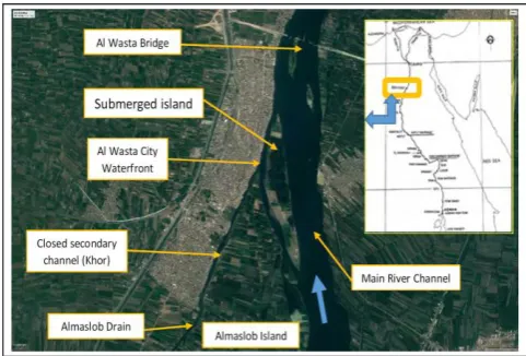
The study reach is located at the waterfront of Al Wasta city, Beni Suef Governorate south of Cairo, Egypt. It is located between (km 81.50) to (km 86.50) from El Roda gauge station (west bank of the Nile River) with the total length of 5.00 kilometer as shown in figure (1). In south of the study area, there is submerged island in the west side of the main channel with 1.15 kilometer length and 200 meters width. The average main channel width from 380 to 650 meters. The closed secondary channel (khor channel) is at the south of Al Wasta city at the west side of the main channel with total length 4.70 kilometers and 60 meters width. There is Almaslob Drain at the south of the khor channel in the west bank. Al Wasta Bridge is
located in the north of the study area which represents the end of the study area. The river flows from the south to the north, with an average bed slope of 0.06%.
Figure 1 : Study Area Location Map
B. Methodology
The method was developed to meet the above goals, and consisted of the following components :
Collection of detailed physical, hydrological and hydraulically field data needed by the subsequent analysis components, including aerial photography, bathymetric, and geomorphic condition data. Geomorphic and morphologic analysis to evaluate
physical constraints to restoration in the reaches, including current and historic characterizations of river bed levels and other geophysical attributes influencing river morphology.
Hydrologic analysis for the different river flow conditions for the study reach (an important river engineering design constraint).
Proposed river restoration alternatives of the study reach.
Development of the two dimensional hydrodynamic model of the study reach to evaluate the hydraulic forces acting under baseline conditions and on selected restoration designs. Evaluate the impacts of selected restoration
alternatives and related activities on channel processes.
C. Data Collection
differential global position system (DGPS). The survey data were carried out according to the coordinate system of (WGS-84), and Universal Transverse Mercator (UTM) projection. More than 100 cross sections were surveyed for the main channel and 30 cross section in the closed secondary channel (khor channel) in year 2013. The field velocity measurements were carried at different (6) cross sections. The vertical integrated of water samples are collected to define the suspended sediment concentration. The analysis of the grain size distribution of 12 bed material samples which are collected during the field observations illustrates that the common type of bed materials is medium sand. The results of analysis of river bed samples showed that the surface layer of the river bed consists generally of medium roughness sand from 40.36% to 86.59%; and fine sand from 2.05% to 16.28%. The grain size diameters range from 430 to 630 microns. The characteristics of the bed samples were used as an input to the model to represent sediment transport process. The suspended sediment concentration is ranged from 31 to 43 ppm and indicates that homogeneity is found to the different collected samples. The actual measured discharge was (69 million m3/day (790 m3/sec)) at the study area at the time of data collections.
D. River Historical for years (1928-2013) Analyses
The first step in applying any restoration techniques is to perform a qualitative historical analysis of river restoration reach. We compared the river boundaries historical changes and the urban expansion at the study reach in form of enforcements (especially at the west bank of the river) which occurred at the years of (1928- 1978- 2003 - 2013) using the topographic maps, with the same scale to be able to monitor the changes that have already occurred during these periods. The study area is characterized by the presence of the submerged islands which are formed at adjacent to the west side of the river channel due to the river sedimentation process in the main channel. These fluvial process changes were leading that the Almaslob Island connected to the river bank directly. In addition, it is observed the urban expansion increased towards the south of Al Wasta area along the west side of the river and increased the human intervention on the khor channel which lead to narrowing the secondary channel (khor channel) at the west side as shown in figure (2).
Figure 2 : The historical changes and urban extension
for Al Wasta Area
The gradual constriction of the khor channel and the river channel width to its current state suggests that the encroachment of development has an impact on the increased deposition and subsequent sediment transport. it is indicated as shown by the reports issued by the authorities that the total inventory of encroachments cases on the Nile River on the study reach before year 2010 were 141 cases, while those violations reached since the beginning of the revolution January 25 until year 2013 were 1095 cases. The nature of the study area at Al Wasta city can be defined through the understanding of the natural system of the Nile River. The decline of water level fluctuation after the construction of the Aswan High Dam, has led to a decline in the annual impact of the flooding on the floodplain areas and the submerged islands. Random urban growth on the west bank of the Nile River and the khor channel in the study area not only to fill the available land, but in a continuous stretch, leading to reduce the khor channel width by 40% during the period from 2004 to 2013 (NRI, 2013) as shown in figure (2).
E. Hydrological Analysis
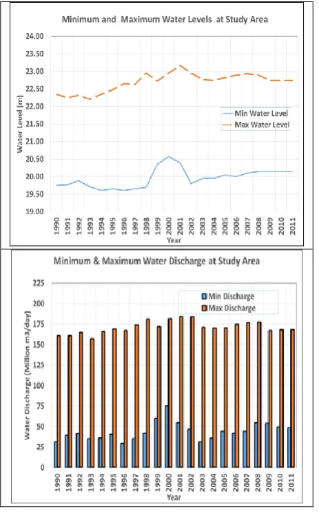
The two gauge stations used are; the first one is the Beni Suef Station (upstream the study reach ) which is located at km (118.40) from El Roda station and the second gauge station is Korimat Station (downstream the study reach) which is located at km (87.85) from El Roda Station.
Figure 3 : The minimum and maximum of water
levels and river flow at the study area
The river flow measured downstream the Assiut Barrage at km (382.22) from El Roda Station. The study shows that the minimum recorded discharge was 29.20 million m3/day (338 m3/sec) in year 1996, the maximum recorded discharge is 184.28 million m3/day (2132 m3/sec) in year 2001. The minimum water level at the end of the study location is equal to (19.60) m, while the maximum water level is (23.17) m as shown in figure (3). It is noticed that there is a high water levels in years (1999- 2001) due to high flood in this period. The water level for the corresponding future discharge release 350 million m3/day (4050 m3/sec) at the study area is calculated as (23.94) m.
F. River Morphological Changes
The river morphological changes at the study area were analyzed by two sets of bathymetric survey of the river bed levels data which was surveyed at years 2003 and 2013. The digital terrain model with 10 meters as finest grid resolution were produced using the bathymetry survey of the river bed elevations of the study area.
Deposition Layer (m)
Erosion Layer (m)
Erosion and Deposition Annual Rate (m)
Figure 4 a : Deposition and Erosion thickness layers
at study area from years 2003 to 2013
Figure 4 b : Comparison of the Cross Sections for the
main channel and secondary channel form years 2003 to 2013
Figure (4-a) shows the magnitude and location of the erosion and deposition areas. It is shown that the sedimentation thickness layer is ranging from (0.50 to 2.50) meters, especially in the khor channel at river west side , reflecting operations of backfill, which take
S
S
1
place during this period between year 2003 and year 2013. Also, the erosion thickness layer are ranging from (0.50 to 2.00) meters, especially through the waterway be due to dredging process associated with the navigation requirements. Figure (4-b) shows the comparison of the cross sections in the main channel and secondary channel for years 2003 and 2013. In general, it is concluded that there is a balance relative between erosion and sedimentation processes in the study area but it the sediment deposition increase at the west side of the river. The comparison of the cross sections of river main channel and secondary channel between years 2003 to 2013 which it is showed that there are intensive sediment deposition inside the secondary (khor) channel. It is observed that there are erosion and deposition process occurs in the river main channel especially at the west side of the river.
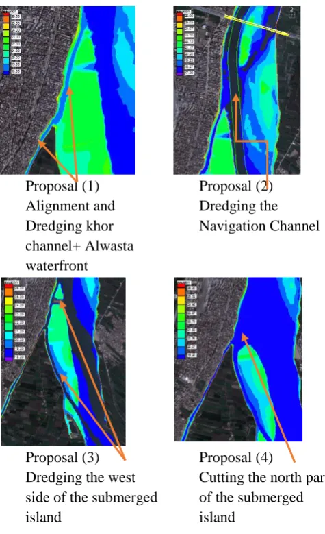
G. Proposed River Restoration Alternatives
River restoration has increasingly drawn attention, and corresponding activities have been carried out extensively (Holmes, 1998). Brookes (1995) and Sear (1994) listed several definitions of restoration but Cairns (1991) provided an encompassing definition as the complete structural and functional return [of the river] to a pre-disturbance state. Where measures are selectively implemented to improve specific aspects of the river, works should be reserved for the complete restoration of habitats within a system-wide holistic framework. Restoration is an appropriate management solution for streams which are degraded in terms of geomorphological, hydraulic and ecological diversity. The four measures alternatives have been proposed for river restoration with addition to the baseline option of taking no action are listed in table (1) for the study reach. These proposals can be summarized as follow:
1) The baseline (no action) represents the No Action alternative, which assumes that no intervention is taken to modify the current physical configuration of the study area.
2) The first proposal is realigned the west river bank boundaries of the closed secondary channel (khor channel). It will be the width of about (25-30) meters and length of 2.00 kilometers from the mouth of the connection point of the khor channel with the main river (khor channel stating point). Also, the khor channel bed level is deepening to the water depth of 1.50 meters below the minimum water level. It is dredged to bed level (18.00)
meters. Moreover, it will be dredged channel at the main river in front of Al Wasta City with length 700 meters and width of about (30-50) meters from the khor channel starting point to the end of the submerged island submersible as shown in figure (5-a). The expected dredging volume will be more than 120,000 cubic meters. This approach aims to increase flow velocity by reducing the natural sinuosity and creating a straight alignment, thereby steepening the bed slope and increasing the energy gradient.
Proposal (1) Alignment and Dredging khor channel+ Alwasta waterfront
Proposal (2) Dredging the Navigation Channel
Proposal (3) Dredging the west side of the submerged island
Proposal (4)
Cutting the north part of the submerged island
Figure 5 : The River Restoration Alternatives
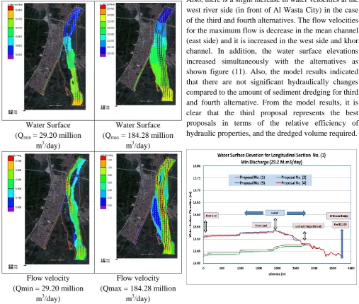
4) The third proposal, with addition to second proposal, the river bed level of the western side of the submerged island is to deepen to level (18.00) meters with average channel width of 30 meters and 1750 meters length, starting from the navigation path from the beginning of the submerged island to the entrance to the khor channel as shown in the figure (5-c). Additionally, it has been dredged channel width of 50 meters and 70 meters width of the northern part of the submerged island submersible which it is divided the island into two parts (north and south) . The expected dredging volume will be 80.000 cubic meters.
5) The forth proposal, with addition to the previous proposals, the northern part of the submerged island north of the khor channel end will dredged channel with total length 770 meters and average width of 150 meters with the level (19.00) meters to improve the water flow currents at the front of the entrance to the khor channel. The expected total dredging volume will be 230,000 cubic meters as shown in the figure (5-d).
TABLE1
THE CHARACTERISTICS OF RIVER RESTORATION PROPOSALS
III.
Hydrodynamic Modelling SimulationA. General
A two dimension numerical model, the Surface Water Modelling System (SMS) is used to simulate the impacts of the proposed river restorations alternatives. The model is developed by the Corps of Engineers. It consists of hydrodynamic model (FESWMS) and
sediment model (SED2D). The ability of model is to allow dry areas within the solution domain during the simulation of an unsteady flow event led to simulate flows on a floodplain problem where flow is initially within the channel, spreads into the overbank areas. The model can calculate water surface elevation and flow velocities for shallow water flow problems and support both steady and dynamic model. Additional tools are provided in SMS to support the modeling of sediment transport. The FESWMS model solves the depth-integrated equations of mass and momentum conservation in two horizontal directions. The depth-averaged surface water flow equations are derived by integrating the three- dimensional mass and momentum transport equations. The vertically integrated momentum equations the flow in the x direction, and for flow in the y direction, the vertically integrated mass transport equation (continuity equation) as followings:
The SED2D model calculates the suspended sediment concentration using the basic convection- diffusion equation, which it is presented in Ariathurai, MacAthur, and Krone as follows:
) 4 ( 1 C y C D y x C D x y C v x C u t C y x
Where C = concentration; t = time; u = flow velocity in x direction; x = primary flow direction; v = flow velocity in y direction; y = direction perpendicular to x;
Dx = effective diffusion coefficient in x- direction; Dy = effective diffusion coefficient in y- direction; α1 = a coefficient for the source term; α2 = the equilibrium concentration portion of the source term. Several options are available in the SED2D model for computing bed shear stresses using τb = ρ(u*)2 , where; ρ = water density and u* = shear velocity which calculates by using either of smooth wall log velocity profile, and the Manning shear stress equation. The sediment load transport determines by using Ackers-White formula.
B. Model Development
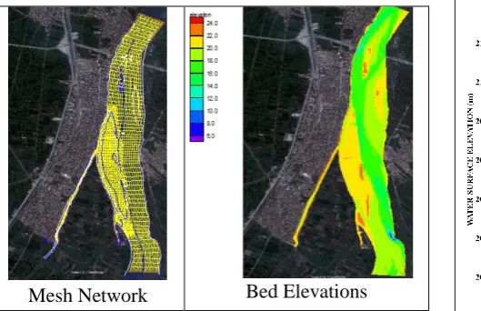
The geometric definition of the study area is given in the form of a finite element network of triangular and quadrilateral elements, known as a mesh, a section of the mesh is shown in figure (6). The elements were sized and oriented to represent hydraulic features, break lines, river boundaries, and topographic changes. Each element contains corner and mid side nodes, which represent points in space (X, Y, and Z) and define the topography of the river reach. The initial mesh was developed using the bathymetric survey at year 2013. The numbers of elements of the mesh are 12479 elements and the numbers of nodes are 49094 nodes. In the river reach, material types within each element were categorized based on land use and roughness characteristics (dense vegetation, grassland, sandbars, etc.). The material types were assigned to each of the elements in the finite element mesh using aerial photography and field data.
Mesh Network Bed Elevations
Figure 6: The model network and river bed elevation
C. Initial and Boundary Conditions
The initial boundary condition of the study area was defined as the initial water levels as well as the bed
elevation in terms of xyz data points. The initial water levels were used to simulate the flow characteristics. The inflow boundary condition is defined as the inflow discharge to the study area which is defined for calibration simulation as 69.00 million m3/day and for verification simulation as 184.28 million m3/day as shown in table (2).
TABLE2
WATER LEVELS AND DISCHARGE FOR MODEL CALIBRATION,VERIFICATION AND SIMULATION
D. Calibration and Verification
Calibration is performed to establish the accuracy of a model. The model was calibrated and verified using the field measurements (water velocities, river bed samples, and suspended solids measurement of the study area). The model is calibrated using an inflow discharge of 69.00 million m3/day and the water level (20.23) m at the downstream boundary condition which represented the river condition at the time of field data measurements.
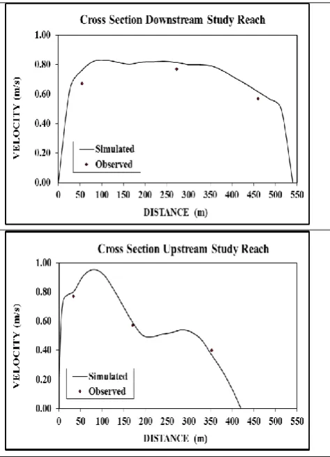
Figure 7: The observed and simulated Water Surface
Profiles (Calibration Process) Model
Scenarios
Initial Flow
discharge Water Levels (m) Million
m3/day m
3
/s Down Stream
The initial roughness values were overestimated were adjusted accordingly. Also, it was verified using an inflow discharge (184 million m3/day) which corresponds downstream boundary condition water level (22.97) m. By comparing the simulated water levels and flow velocities at the study area with the measured data, it shows acceptable model calibration and verification process as shown in figure (7) and figure (8).
Figure 8: The measured and simulated flow velocity
for study area (Calibration Process)
IV.
RESULTS AND DISCUSSIONSThe numerical model was applied for three scenarios of river flow for the minimum, maximum, and future water discharge (29.20, 184.28, and 350.00 million m3/day) to examine the impact of proposed restoration alternatives on the river morphology of the study reach. The minimum river discharge represents a critical situation in terms of entry of water into the khor channel, navigation path and the submerged islands. The model was used to calculate the river flow ratio around the main submerged island at the study reach as shown in table (3). The results shows that the main
river flow located at the east side of the river channel. The water levels and water velocities are the key hydrodynamic response parameters to an alternative’s physical configuration. Therefore the flow velocities and water surface elevations of these proposals have been compared using three longitudinal sections as shown in figure (9) which presented as followings:
1) The first sector is the longitudinal section at the khor channel, starting from Almasloub Drain to the connection point with the main river channel, then in front of the Al Wasta City and ends at the bridge.
Figure 9 : longitudinal sections locations
2) The second sector represents the longitudinal section of navigation channel from south of the study area to the Al Wasta Bridge.
3) The Third sector is the longitudinal section going through the western bank of the submerged island, then in front of the entrance of the khor channel, then in front of the Al Wasta City and ends at the Al Wasta Bridge.
TABLE3
RIVER FLOW RATIO AROUND THE ISLAND AT THE STUDY REACH
River Flow Discharge
Flow Distribution Percentage
Submerged Islands Location Submerg
ed Island
(A)
Bridge Island (B)
Scena rios
Milli on m3/d
ay W est
( W 1)
Eas t (E1
) We
st (W 2)
East (E2
)
Mini mum
96.9 7
1 %
99 %
82 %
Maxi mum 82;. 92 4 % 96 % 48 % 52 % Futur e 350. 00 8 % 92 % 43 % 57 %
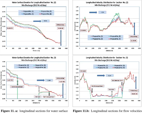
Hydraulic characteristics of the river reach were compared for the three longitudinal sectors and the results are as shown in figure (10) and figure (11). A comparison between the four alternatives for the development of the river reach and the change of the khor channel water velocities values and water surface elevations are shown in table (4). The model results show slight improvement in the distribution and values of water velocities at the western bank of the study area and khor channel from the first alternative to the four alternative. In addition, the water flow velocities at the khor channel are not affected significantly as a result of the proposed alternatives.
Water Surface (Qmin = 29.20 million
m3/day)
Water Surface (Qmax = 184.28 million
m3/day)
Flow velocity (Qmin = 29.20 million
m3/day)
Flow velocity (Qmax = 184.28 million
m3/day)
Figure 10: The river flow velocity and water surface
profile
TABLE4
RIVER RESTORATION ALTERNATIVES EVALUATION FOR THE MINIMUM AND MAXIMUM RIVER DISCHARGE
Baselin e Proposal No (1) Proposal No (2) Proposal No (3) Proposa l No (4) Flo w M in M ax M in M ax M in M ax M in M ax M in M ax Sect io n (1 )
W. S (m)- 19
.4 7 19 .4 7 23 .1 2 19 .4 5 23 .1 0 19 .5 3 23 .0 7 19 .5 4 23 .0 8
V (m/ s)- 0. 03 0. 09 0. 03 0. 08 0. 04 0. 07 0. 06 0. 07 0. 04 Sect io n (2 )
W. S 19(m)
.7 3 23 .2 3 19 .7 3 23 .2 3 19 .7 1 23 .2 2 19 .6 8 23 .2 1 19 .6 7 23 .2 0
V (m/ 0.s)
55 1. 05 0. 55 1. 05 0. 58 1. 01 0. 58 0. 95 0. 58 0. 92 Sect io n (3 )
W. S (m)- 23
.2 4
- - - 23 .2 4 19 .6 7 23 .2 2 19 .6 8 23 .2 1
V (m/ s)- 0. 28
- - - 0. 28 0. 11 0. 32 0. 16 0. 39
*W.S = Water Surface V= Flow Velocity
Figure 11. a: longitudinal sections for water surface for the restoration alternatives
Figure 11.b: Longitudinal sections for flow velocities
for the restoration alternatives
V.
CONCLUSION
proposed restoration alternatives are higher than the existing conditions. It is concluded that the third proposal represents the best proposals in terms of the relative efficiency of hydraulic properties, and the dredged volume required. In addition, it should design ways to protect the submerged islands and khor channel banks by using new types of environment-friendly materials to control the urban extension patterns. It is recommended taken into account other factors (environmental-social-economic and urban planning) to reduction the river encroachments.
VI.
REFERENCES
[1] Attia, K., and El Sersawy, H. (2004), “Realignment of West Side of the River Nile Downstream New Esna Barrages Using Mathematical Models”, NRI Technical Report in Arabic.
[2] Brookes, A. (1988), Channelized Rivers: Perspectives for Environmental Management. Wiley, Chichester, 326 pp.
[3] Brookes, A. (1995) a. River channel restoration: Theory and practice. In: Gurnell, A. and Petts, G. (Eds.), Changing River Channels. Wiley, Chichester, 369-388.
[4] Brookes, A. (1996). Floodplain restoration and rehabilitation. In: Anderson, M. A., Walling, D. E. and Bates, P. D. (Eds.), Floodplain Processes. Wiley, Chichester, 553-576.
[5] Cairns, J., Jr. (1991). The status of the theoretical and applied science of restoration ecology. The Environmental Professional, 13, 186-194.
[6] Chang, H.H. and Hill, J.C. (1976). “Computer Modeling of Erodible Flood Channels and Deltas”, J. Hydraul. Div., ASCE, 102 (HY10), pp.1461-1477, October 1976.
[7] Chang, H.H. (1988). “Fluvial Processes in River Engineering”, Abook published by Wiley Interstice Publication, John Wiley & Sons, Inc., ISBN 0-471-63139-6.
[8] Holmes, N. T. H. (1998). The River Restoration Project and its demonstration sites. In: de Waal, L. C., Large, A. R. G. and Wade, P. M. (Eds.), Rehabilitation of Rivers: Principles and Implementation. Wiley, Chichester, 133-148. [9] Finite Element Surface Modeling System
(FESWMS) (1991), Two Dimensional Flow in a Horizontal Plane. User’s Manual, Highway Research Center, Pike, McLean, Virginia.
[10] Nile Research Institute (2013), "Development of Waterfront of Al Wasta, Beni Suef, Egypt". Technical Report.
[11] Nile Research Institute, (2003). "Hydrographic and Topographic Maps of the River Nile". [12] Poff L. N., Allan D., Bain M. B., et al.(1997).
The natural flow regime, a paradigm for river conservation and restoration [J]. Bioscience, 47,769–784.
[13] Richards KS. 1982 Rivers: Form and Process in Alluvial Channels. Methuen: London.
[14] Sear, D. and Newson, M. (1994). Sediment and gravel transportation in rivers: A geomorphological approach to river maintenance, policy and implementation recommendations. R&D Note 315, National Rivers Authority, Bristol, 28 pp.
[15] Schumm SA. 1973. Geomorphic thresholds and complex response of drainage systems. In Fluvial Geomorphology, Morisawa (ed.). Publications in Geomorphology: SUNY Binghamton; 299–309.