(PLATES 1-26)
AFTER TEN YEARS of systematic excavation in the Sanctuary of Zeus at Nemea by
LT"X. the University of California at Berkeley1 and the dedication of the new archaeological museum on May 29, 1984 (P1. 1),2 efforts were to have moved into a phase of study and
final publication. This new phase was to include the landscaping of the site and its develop- ment into an archaeological park closely integrated with the displays in the museum. That goal could not be accomplished, however, without the closing of the country road which ran east-west through the southern part of the Sanctuary (P1. 2:a).3 Efforts to close this road included the construction of a detour4 and the intervention of the Ministry of Culture.5 The road was finally closed on November 11, 1984 and the whole site enclosed by fencing as a single unit. Excavations in the area of the road (Grid Sections K 19, L 19, M 19, M 20, N 19, N 20, and 0 19, Fig. 1) were undertaken during November 1984, May and Novem- ber 1985, and November 1986.6 Although essentially intended to allow the landscaping of the newly unified site, significant archaeological results also emerged.
I See the annual reports: Stephen G. Miller, "Excavations at Nemea, 1973-1974," Hesperia 44, 1975, pp. 144-172; "Excavations at Nemea, 1975," Hesperia 45, 1976, pp. 174-202; "Excavations at Nemea, 1976," Hesperia 46, 1977, pp. 1-26; "Excavations at Nemea, 1977," Hesperia 47, 1978, pp. 58-88; "Excava- tions at Nemea, 1978," Hesperia 48, 1979, pp. 73-103; "Excavations at Nemea, 1979," Hesperia 49, 1980, pp. 178-205; "Excavations at Nemea, 1980," Hesperia 50, 1981, pp. 45-67; "Excavations at Nemea, 1981," Hesperia 51, 1982, pp. 19-40. Stella G. Miller, "Excavations at Nemea, 1982," Hesperia 52, 1983, pp. 70-95; "Excavations at Nemea, 1983," Hesperia 53, 1984, pp. 17 1-192.
2 This museum, which provides for a total of 1,375 sq. m. of display, storage, office, and laboratory space, is
the gift of Mr. Rudolph A. Peterson of San Francisco, California, and the University of California at Ber- keley. The funding of costs of the display cases and of the displays themselves was aided by a number of indivi- dual donors including Mrs. Phyllis Wattis, also of San Francisco.
I Aerial photographs were once again taken of the site at the end of May 1984, by Wil and Ellie Myers whom I would thank most warmly for their good work, several examples of which appear in this and previous reports.
4 See Hesperia 52, 1983, p. 88, note 68. This difficult process was helped by many people. I would thank
the members of the town council of Archaia Nemea during the period 1978-1982: I. Malakos (Mayor), A. Mouschouras (Secretary), G. Panagos, K. Papaioannou, G. Papaioannou, and P. Derdenes; the land- owners: A. Xydes, M. Asimakopoulos, I. Niteros, G. Douros, and S. Skleres; the Governor of the Korinthia, A. Stavropoulos; and Mr. and Mrs. T. J. Long of Alamo, California, whose financial support was crucial.
5 Sudden local minority opposition to the closing of the road was encountered in 1983 and overcome only through the assistance of the Minister of Culture, M. Merkouri, the Secretary-General of the Ministry, K. Alavanos, and the members of the Central Archaeological Council, all of whom are to be thanked and congratulated.
6 This work was aided by the Archaeological Service and its Director of Antiquities, I. Tzedakis, and by
various members of the Nauplion Ephoreia of Antiquities, most notably E. Palaiologou, E. Korka, Z. Asla- manzidou, and P. Pachyianni. Also of assistance were several of the guards at the site in whose behalf I would thank the head guard, A. Vakrinakes. For varying portions of the different periods the staff included D. Birge, D. Christopoulou, M. Hoff, S. Katakis, L. Kraynak, E. Lambidaki, C. Lehmann, E. Nikolopoulos, A. Papa- konstantinou, S. Petrakis, T. Rhodolphou, A. Stewart, N. Themis, and T. Winters. Photography was the responsibility of C. and M. Mauzy with supplemental work by the undersigned, and the architectural work was done by Aik. Sklere and the undersigned. The work was supported by more than 100 private donors
Hesperia 57, 1
American School of Classical Studies at Athens is collaborating with JSTOR to digitize, preserve, and extend access to
Hesperia
D P P G H - - - K L - N 0 P - | R
l l f : I a 0 i~~~~~~~~~~~~~~ ~~ANCTUAR OF ZEU;
17 17
13 1
16 ~ ~ ~ ~ ~ ~ ~ ~ ~~ I14
k~~~~ o
_ _
17_1 -rt0 __; _ ; t_ 4
|---W- t-Xi~~~~~-rA- 7I- ,W7X-]--I-7
20 0 1[ 1;_ ^ |1 20
P E F G H 2 P L
-r
P
R-P - -
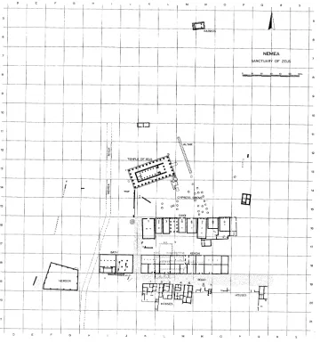
FIG. 1. Restored plan of the Sanctuary of Zeus, Archaic to Hellenistic periods
THE MEDIAEVAL TO EARLY MODERN PERIODS
Although inhabited only sporadically between the 6th and the 19th centuries after Christ, to judge from the material discovered in the excavations, clear evidence has emerged in the ceramic and numismatic material for activity during the 14th and 15th centuries. It seems to have been centered upon the small chapel which had been built over the remains of the Early Christian basilica.7 The most substantial traces were in the form of a series of some 25
through the University of California at Berkeley, and the American School of Classical Studies at Athens gave much valuable assistance. To all these institutions and individuals, as well as to the local workmen at Nemea, goes my sincere gratitude.
graves along the south side of the basilica toward its east end (Pls. 2:b, 3:a).8 These graves were oriented in the canonical way, with the head of the deceased at the west, and were built of thin, vertical stone slabs with larger stones covering the whole grave. Many of the latter were ancient architectural blocks (e.g. a Doric capital: A 258; P1. 3:a, b), frequently from the Temple of Zeus, and of considerable size and, perhaps significantly, weight. Eight of the graves had the skeletal remains of two or more people, and the contents of all were poor, with only an occasional piece of jewelry (e.g. a finger ring, GJ 118; P1. 3:c), or belt buckle (e.g. IL 578; P1. 3:d), and in one instance a coin of the Turkish period (C 3830; P1. 4:a, b). All of this, plus the stratigraphic contemporaneity of the graves, suggests some sort of ca- lamity which overtook the small settlement.
THE EARLY CHRISTIAN PERIOD
Dispersed over a much wider area than the Mediaeval graves were several more of charac- teristic type, lined and covered with large terracotta Laconian tiles (e.g. M 19: Grave 29; P1. 4:c) with, frequently, a smaller Laconian tile placed as a "pillow" for the head of the de- ceased (e.g. L 19: Grave 3; P1. 4:d). These 21 simple graves9 belong to the 5th or, more likely, the 6th century after Christ and are typically poor, although they did produce a few pieces of bronze jewelry, two belt buckles (IL 567 and BR 1198; P1. 3:d), a cross-incised bead (GJ 120; P1. 5:a), and several pendants in the form of crosses of various types and materials (GJ 106, GJ 109, GJ 110, IL 530; P1. 5:a). The religious beliefs of this settlement cannot be in doubt.
A bit of information about the basilica itself came in the form of a pit with remains of slaked lime just south of the basilica's south aisle at M/3,6-19/2,6 (P1. 5:c). The pit is probably to be associated with the manufacture of cement for use in the foundations of the basilica or of plaster for its walls, only a very few traces of which have survived. The fill of this pit included the handle of a glass goblet (GL 50; P1. 5:b) and at one time doubtless large quantities of marble from the earlier sanctuary of Zeus.
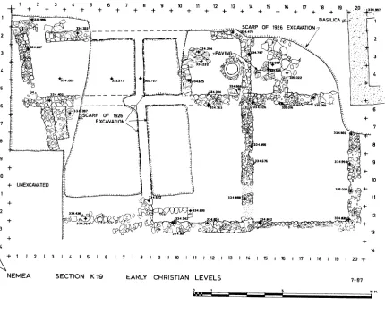
At the southwest corner of the basilica, there emerged a large structure in Section K 19 (Fig. 2). The newly discovered walls are almost certainly a part of the house found im- mediately to the west in 1982.10 As exposed in K 19, the building consists of seven or eight rooms with walls constructed of rubble, above which was probably mud brick. Some of these walls utilized older blocks such as fragments of the marble sima of the Temple of Zeus (e.g. A 249; P1. 5:d). The rooms are arranged in two east-west rows, the northern of which produces a relatively standard north-south width of about 3.10 m., the southern about twice that. The eastern limit of the northern row of rooms is the west wall of the small room south of the basilica's narthex (P1. 6:a),11 and the line of this wall was extended southward by the east wall of the southern row of rooms. The whole structure is therefore not only later than the basilica but also an architectural dependency of it.
8 Graves 1-16 and 18-26 of Section M 19.
9 These graves (all of which are outside the basilica) show a marked concentration in the proximity of that
structure: four in K 19, four in L 19, twelve in M 19, and one in N 19.
10 Hesperia 52, 1983, pp. 84-87.
1 2 3 4 5 6 7 8 9 10 11 12 13 14 15 16 17 18 19 20 +4 7
1"G BASILICA -X 1
334-167 ~ ~ VA 3 4"
3 PAVIN A OF 12 EXCAVATION7
12 2e 1"7"?4mS + 13
3 ~~~~~~~~+3.03. 37 72 42
14 X
L /
6 A3476-_L7
NEMEA SETONK1 ERYCHITANLVL578EXCAVATION
7
8 ~~~~~~~~~~~~~~~~~~~~~~~~~~~~~~~~~~~~~~~~~~3.%8
10
~~~~~~~~~~~~~~~~~~~~~~~~~~~~~~~~~~~~~~~~~~~~~~~10
+ UNEXCAVATED 352
12
341
13 1
14 1
+ 1 12 13 1 4 15 16 17 181 101I11 1 12 1 13 114 1 5 i r 1 17 1 18 119 120?
NEMEA SECTION K 19 EARLY CHRISTIAN LEVELS 7-87
FIG. 2. Section K 19, Early Christian levels
Parts of the northern wall and of the area at K/5,10-19/1,10 had been uncovered in excavations of 1926.12 Here the walls appear to have been left exposed for a period of time,
and this led to their collapse, but the ridges of earth upon which the walls had stood re- mained for us and allow the restorations of the lines of the walls in plan (Fig. 2, P1. 6:b, c). All the rooms excavated by us except the southeastern one at K/15,19-19/6,12 were cov- ered by a heavy layer of tile destruction debris with no sign of burning (P1. 7:a, b). This suggests that the large southeastern room (ca. 5.30 x 6.50 m.) was an open court entered from the east through a gap at its northeast corner; i.e. at the southwest corner of the basilica
12 For those excavations see C. W. Blegen, "Excavations at Nemea 1926," AJA 31, 1927, pp. 421-440.
Although no mention is made of these walls in that publication, there is a brief description and a sketch plan in Nemea notebook 7, p. 37, for December 16, 1926, by B. D. Meritt.
(K/20-19/6,7; Fig. 2). The functions of some of the other rooms are suggested by storage facilities at K/13-19/3,4, paving in the same room and its eastern neighbor, a bench in another room at K/3-19/6,7, and a series of iron tools found at the western end of the structure (e.g. Il 528; P1. 7:c).
A single thin floor layer found below the destruction debris suggests a brief life for this
house.13 Lamps from this layer of use (L 216) and from that immediately beneath it (L 220;
P1. 8:c)14 should place the occupation of the house within the 6th century after Christ. The numismatic evidence includes three coins which once again indicate that the date of the Slavic invasion in the 580's after Christ is correct: C 3570 and C 3733 of Justin II (A.D. 572
and 573, respectively) and C 3568 of Tiberius II (A.D. 578-582; P1. 8:a, b).15
Elsewhere in the general area south of the basilica scattered artifacts, such as glass vessels (GL 46, GL 47, GL 49; P1. 5:b) and lamps (L 215, L 217, L 224; P1. 8:c), were found in stratigraphic contexts which antedate both the house and the graves. These clearly show a certain level of activity in a slightly earlier period, but the nature and extent of that activity cannot be defined more precisely even though the possibility of association with the construction levels of the basilica is clear. On the other hand, the Early Christian settlement presumably had to establish itself to some extent before building its church.
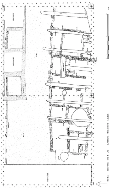
In this context we should mention two other features of the region. The first of these is the stream which runs through from east-northeast to west-southwest (Figs. 3, lower right, 4, P1. 8:d). This stream had been noted before, but no evidence was found in the recent work to confirm its suggested inception in the 3rd century after Christ.16 It was already running through this area in the Early Christian period, as is once again shown by ceramic material from near its bottom. 17 The same conclusion emerges from the discovery of the continuation of the drain first found in 1978.18 As revealed in the southwest corner of Section L 19, this drain was well constructed with a floor lined with Laconian tiles and built walls which turned twice at right angles to rise sharply toward the north (P1. 9:a). The more northerly and higher parts of this drain have not survived, and its connection with the basilica must remain hypothetical but extremely likely. Its basic purpose presumably will have been to carry rainwater away from the church and into the river. Four Frankish silver coins (C 3690, C 3691, C 3834, C 3835; P1. 4:a, b) together with late Byzantine pottery from the uppermost fill of the river confirm that the stream continued to flow throughout the Me- diaeval period.19
The second feature has also been noted previously. This is the series of long, narrow trenches which were cut on roughly parallel, north-south lines, about 4 meters apart.
13 The same conclusion was reached for the house immediately to the west in Section J 19; Hesperia 52,
1983, p. 86. It may, as noted above, be another part of the same construction.
14 For L 216 compare J. Perlzweig, The Athenian Agora, VII, Lamps of the Roman Period, Princeton
1961, no. 2591, and A. Bovon, Etudes pe'loponne'siennes, V, Lampes d'Argos, Paris 1966, no. 639; for L 220 compare ibid., no. 625.
15 For other evidence at Nemea of this destruction and its date see Hesperia 52, 1983, p. 87, note 82.
16 Hesperia 48, 1979, p. 90.
17 Pottery lot N 19:6.
18 Hesperia 48, 1979, pp. 90-92.
1 2 3 4 5 6 7 8 9 10 I1 12 13 14 15 16 17 18 19 20 1 2 3 4 5 6 7: 8 9 10 1t 1 12 13 14 1s 16 17 18 19 20
++ + + + ? +?? + - ? +i -+ ? + ? + ++- ? ---+~--?~
+ AQUEDUCT ,
2 2
+ U ONEXCAVATED 0 0 0 0 X 0UNEXCAVATED 0: ' '
4 4~~~~~~~~~~~~~~~~~~~~~~~~~~~~~~~~~~~~~~~~~~~~~~~~~~~~~~~~~~~~~~~~~~~~~~~~~~~~~~~~~~~~~~~~~~~~~
+ t
ROAD ' ,BASILICA
6 - 6
+ -I-.. - +,.. -[w
8 ROAD
+ _
10 1 I
+ UNEXCAVATED
21 1 1
3 9 5 7
31923 28
FIC;* 3 Sections K 19 and L 19> Classical to Hellenistic levels~~~~~~~~~~~~~~~~+ 33~94
+~~~~~~~~~~~~~~~~~~~~~~~~~~~~~~
13 13
14+34UAATD34- 14P
+~~~~~~~~~~~~~~~~~~~~~~~~~~~~~~~
16 18
17 41234U34 417
18 ES 3,042S18
19 341
3D 2 ~ ~ ~~~~~4 8-F 7 + 8 H- 1 12+ 14 A- 16~' 17 18 19 + ~ 2 3+4+5+6 7? 9 10 1 -F 12 + 1h -is +6 +7 ?8 1
NEMEA SECTIONS K 19 & L 19 CLASSICAL- HELLENISTIC LEVELS 7-87
+ 14,,
3 NXAAE 3
7 ~~~~~~~~~~~~~~~~~~~~~ROAD
7~~
12 ~~~~~~~~~~~~~~~~~~~~~~~~~~~~~~~~~~~~~~~~~~~~72773 127C
N M A S2
'S M1. M 20. N 1. N. SO 0- ', '- . , '-,' + +EkAF 4. S M 1 M 20, N , N 20, a 0 19, Classical t Hlstic levels
t,,.:r r'tol ; _%
20
20S33S 2>" A4
2 +t_ .
+ , +
2 3
23 t 1 1 3 1 S i 7 1 S 2 1 2 3 4 5 6 7 e 9 l 2 1 4 1 6 1 8 t N NEE+ETOS M1 2 N1/N2JO1
e -i
Known earlier in Sections L 20, 0 19, Q 19, and Q 20,20 they have now been documented in K 19, L 19, M 19, and M 20 as well (Figs. 3, 4; P1. 9:b, c). These "Roman trenches" cut through earlier cross walls and even rob out north-south walls which lay along their path. Together with the masses of earlier material found in these trenches (e.g. C 3666, C 3668, C 3723, C 3780, C 3796, C 3797, C 3799, C 3800, C 3849, C 3853, C 3882; P1. 10:a, b),21 some evidence was discovered which confirms the 1 st-century B.C. date already suggested for
them.22 Their purpose remains enigmatic, for they can now be said definitively to antedate the stream, and therefore they have no apparent connection with irrigation as suggested previously. They, like the stream, obscure the earlier remains.
THE CLASSICAL AND HELLENISTIC PERIODS
THE ROAD, THE XENON, AND THE AQUEDUCT
It has long been known that a major east-west road ran along the south side of the Sanctuary of Zeus next to the Xenon (Figs. 1, 3, 4).23 Considerable additional information has now been recovered about the history of this road. A test at K/14,20-19/10,11 shows it to have first existed in the 6th century B.C., although there could conceivably be earlier levels
to the north of the limits of the trench (P1. 10:e). A series of gravelly layers shows heavy traffic throughout the later Archaic period and most of the 5th century B.c.24 The southern limit of the road in the 5th century seems to have been formed by a building (see below), although the line seems to have been well established before any buildings were added to the area. As is the case throughout the sanctuary, so too the road shows no trace of activity during the first half and more of the 4th century B.C. It is only in the early Hellenistic period
that it begins to be traveled once more, and this use continues into the 3rd century.25 These layers of road metal have produced a number of coins (C 3734, C 3736, C 3738, C 3740, P1.10:c, d; C 3930, P1.23:c, d),26 but the pottery is extremely fragmentary as is to be expect- ed from a heavily traveled thoroughfare.
In this early Hellenistic period, the road had a width which ranged from about 10.5 to more than 12 meters and was bordered on the north by the Xenon, on the south by the houses discussed below (pp. 9-16). To be sure, the effective road width was rather less as is shown by the softer surface at its edges, and as is to be expected next to buildings. The "sidewalk" was especially important next to the Xenon where the aqueduct brought water from a spring on the east side of the valley to the Bath House west of the Xenon (Fig. 4). The aqueduct was examined in detail in Sections K 19 and 0 19. In the former area, it had the same construction as has been noted in L 19: a U-shaped terracotta channel, squared on the exterior bottom (cf. below, TC 206; P1. 17:a), over the top of which were set normal
20 Hesperia 51, 1982, pp. 27, 28, and 30-32, respectively.
21 C 3666, Chalkis; C 3668, Kleonai; C 3723, Phlious; C 3780 and C 3796, Sikyon; C 3797, Aigina;
C 3799, Sikyon; C 3800, Corinth; C 3849, Arcadian League; C 3853, Sikyon; C 3882, Argos.
22 Hesperia 51, 1982, p. 32; pottery lots K 19:58, 93.
23 Hesperia 50, 1981, pp. 57-58; 51, 1982, p. 30; 52, 1983, p. 92. 24 Pottery lots K 19:84-92.
25 Pottery lots K 19:53-55.
Corinthian cover tiles.27 The latter, in some obvious places of repair, are sometimes re- placed by pan tiles or Laconian tiles.
In Section 0 19 the situation is slightly different. Although the water-bearing channel here was also made of the U-shaped tiles, it is covered by a series of Laconian ridge cover tiles reminiscent of a row of beads (P1. 11 :a, b). These are interrupted by stone cover slabs which protect the aqueduct directly in front of a door to the Xenon at N/20,0/1-19/1. Although this stone covering is only repeated at one other door in the south wall of the Xenon (at N/8,9-19/1), it might be taken to indicate that the building has a slight chrono- logical priority to the aqueduct. The date for both was confirmed, in part by a bronze Sicyonian coin (C 3854) from the second half of the 4th century B.C. A test in Section M 19
revealed more details about the relative chronology of Xenon and aqueduct: from the strati- graphy here it was very clear that the former existed before the latter (P1. 1 1:c). The ma- terial from the trench of the aqueduct and of the Xenon ground level through which it was cut could not, however, be diagnosed in terms of absolute chronology.28
At some point in the first half of the 3rd century B.C. the road ceased to be used.29 This
conclusion emerges clearly from a heavy layer of debris over the highest layer of road metal, in which were found pottery (e.g. P 1450; P1. 12:a) and coins of early 3rd-century date, although earlier material was also present.30 This debris was also filled with broken roof tiles and many iron and bronze nails, but there were no significant traces of burning. It included a folded lead tablet which reads: \pV4l1os, "A vt7rTos (IL 532; P1. 12:d).31
Above this layer of debris in the eastern areas (for much of L 19 and eastward), the next stratigraphic unit is a thick silted fill which came to form the surface of the Early Christian period. To the west, however, there intervenes a thick layer that is to be associated with a series of pits of varying depths, which were dug into the earlier road surfaces (and floor levels of the houses to the south; see below). This layer and its pits were rich in artifacts such as nails, lamps (L 219, L 221; P1. 12:c), terracotta figurines (e.g. TC 189; P1. 12:b), pottery of various types including the base of a large moldmade bowl with comic-mask appliques for feet (P 1417; P1. 13:a), an unguentarium (P 1423; P1. 13:c), and a bowl on the bottom of which is the scratched graffito 'ItXlo-T-a (P 1426; P1. 13:b), and coins C 3672, C 3674, C 3679, C 3693, C 3695, C 3697, C 3701, C 3708, C 3712, C 3724, C 3727, C 3729; Pls. 13:d, e).32 Much of this material belongs to an earlier date, but the whole period of activity can be securely dated to the second half of the 2nd century B.C. on the basis of
fragments of ceramics such as "Pergamene Ware", long-petal bowls, etc. The purpose of the
27 Cf. Hesperia 50, 1981, p. 58. 28 Pottery lot M 19:66.
29 Such a suggestion was first made in 1980, but the evidence is now much greater and conclusive; cf. Hes-
peria 50, 1981, p. 58.
30 Pottery lots K 19:46-52; L 19:117, 122, 145; M 19:63-65; N 19:9; 0 19:30, 31.
31 It is tempting to identify this Drymos with the Argive athlete who won the dolichos at Olympia in
328 B.C. and reported the victory himself on the same day at Epidauros; cf. IG IV2, 1.618.
32 Pottery lots K 19:36, 38-40, 48. Coins C 3672 and C 3674, Sikyon; C 3679, Argos; C 3693 and C 3695,
digging and filling of the pits and the leveling of the area is not clear (but see below), for there is no evidence of a renewed use of the road at this time or thereafter. Indeed, the road had long since ceased to exist by the end of the 2nd century.
THE HOUSES
Remains of domestic architecture had been found earlier at various points south of the road.33 Our knowledge of those structures has now been increased significantly, and it is possible to treat them, with varying degrees of precision, as architectural units.
House 1
This is the westernmost structure of the series, at least as now exposed, and is located in Sections K 19 and K 20 (Figs. 1 and 3; P1. 14:a, b). The southern part of the house was excavated in 1981 and was discovered to have been largely destroyed by the river, although the southern limits might well still exist in unexcavated areas.34 It would seem to have had an east-west width of about 14.60 m. at the north and perhaps as much as 20 meters or more in north-south length. We may note, although an explanation is not immediately obvious, that the north or facade wall of House 1 makes a clear bend to the southwest at about K/18-19/10. The house appears to have been approached through a passageway some 2.50 m. wide which it shared with House 2. The passageway itself is entered from the road at the north at L/3,4-19/11 and has a cluster of cobblestones on the road side of a low wall which filled the gap between Houses 1 and 2 at a time after the construction of both (P1. 14:c). The purpose of this wall will have been to retain the growing layers of road gravel. In addition to rooms opening off its west side, the passageway seems to have ter- minated in a large courtyard which occupied the southeastern part of the house. The ex- treme southeast corner of that area may have been that where the hydraulic cement paving was discovered in 1978 at L/2,4-20/7,8.35 Given the state of preservation of the remains in the area of the river, this suggestion is obviously very tenuous. It is clear, however, that the collapsed well at K/8-20/3,4, discovered in 1981, does belong to House 1.
The construction of House 1 varies from rubble walls to those which incorporate large re-used blocks, especially in the east-west wall at K/1 1,17-19/20. With the exception of such walls, however, and wherever the remains are preserved to a sufficient height, the rubble walls exhibit a leveling course of re-used roof tiles which will have served as the bedding for mud brick above.36 This same construction technique is to be seen in all the other houses discussed below (cf. Pls. 19:d, 21:a). The same uniformity is true of doorways, which are marked merely by an absence of foundations and only rarely by any sign of threshold or jambs. Despite this informal construction, the building must have presented a
33 Hesperia 48, 1979, pp. 90-93; 51, 1982, pp. 24-25. 34 Hesperia 51, 1982, pp. 24-28, fig. 3.
35 Hesperia 48, 1979, p. 93.
36 To judge from village architecture of the early part of this century, a wood tie beam might well have been
rather gay facade, at least if the terracotta sima found in its final destruction debris can be associated with it (AT 268; P1. 15:a).37 With regard to that destruction it should be noted that a clear and heavy layer of debris existed only over the western room located at K/7,12-
19/16,19 (P1. 15:b). All other rooms exhibited clear signs of post-destruction digging and trenching while this room seems to have survived such activities. Perhaps its final destruc- tion was later than that of the remainder of House 1.
This final phase in the history of House 1 is represented, for example, by a large pit which cut into the south and east walls of the room at K/13,17-19/16,20 (P1. 15:c). The pit was covered by a layer which produced a bronze lamp (BR 1191; P1. 16:a) and a moldmade bowl with a scene of women around a trophy and the vertically arranged letters HKV, perhaps the signature of the manufacturer (P 1437; P1. 16:b). The material from the pit itself was similar and included among many other artifacts two lamps (L 222, L 223; P1. 12:c),38 another moldmade bowl (P 1438; P1. 16:c), and a bronze weight (BR 1194; P1. 16:d). The last is especially interesting for it bears a central ligature T which may stand for Tp9OV,39 and the inscription AFPEI/fN A\AMO0/ON. This is clear testimony to the extent of Argive influence, not to say authority, over the Sanctuary of Zeus at Nemea at this time.40 It would be nice to be able to define this period more precisely. The material present- ed above, and much more,41 brings us clearly into the 2nd century, but it is not clear whether it must be as late as 145 B.C. when Mummius undertook some initiative with regard to the
Nemean Games.42 Furthermore, there is a strong temptation to connect this pit and the final destruction of the room just to the west of it with the heavy debris over the road to the north as mentioned above (p. 9). With the exception of a very few fragments of long-petal bowls, however, the latest material would be a generation or two earlier than Mummius. That fact, in itself, is of interest for that period has not been much in evidence at Nemea heretofore.
The room immediately to the west of this pit at K/7,12-19/16,19 adds more to the picture. As mentioned before, it is the only room in the house where the destruction layer was massively clear. In addition to a great many tiles, mostly, although not exclusively, Laconian, an abundance of pottery appeared including the other two relief-decorated feet of a moldmade bowl, the first foot of which was found in K 20 in 1981 (P 1449 a and b; P1. 16:e).43 Although much of the material belongs earlier in the Hellenistic period, some of
The undersurface of this tile was incised before firing with the letters ,E.
38 Cf. R. H. Howland, The Athenian Agora, IV, Greek Lamps and Their Survivals, Princeton 1958, type
33A, dated from the last quarter of the 3rd century B.C. into the first quarter of the 2nd century.
39 The weight of the piece is ca. 170 grams.
40 On this point see Hesperia 48, 1979, pp. 79-80; Stephen G. Miller, "Kleonai, the Nemean Games, and
the Lamian War," Hesperia, Suppl. XX, Studies in Athenian Architecture, Sculpture, and Topography, Princeton 1982, p. 107.
41 Pottery lots K 19:64, 66, 73, 74, 76.
42 Hesperia 51, 1982, p. 28, and references therein.
it is as late as the second half of the 2nd century B.C.44 Immediately beneath this destruction layer emerged a fragment of the aqueduct which originally ran along the south side of the Xenon (see above, p. 8). It is the characteristic U-shaped terracotta (TC 206; P1. 17:a) and still has masses of lime incrustation adhering to it, clearly from the time when it was in use as a part of the aqueduct.
The final phases of House 1 seem, then, to represent a new chapter for the history of Nemea. It does not require too much imagination to envisage, in the 2nd century B.C., a
single room of the earlier house standing in isolation and serving as the center of a clean-up operation which was destined to be fruitless. The impetus for this activity may well have been the decree of Mummius mentioned above, and it will have been carried out under an Argive authority which was real, and not very energetic. Whatever Mummius' intentions, there will have been no great Argive appetite for returning the Nemean Games to Nemea.
Due to the later activity in the area, evidence for the original date of construction for House 1 was not easily identified. It does seem, however, to point toward the second half of the 4th century B.c.45 It is clear that there was a phase of activity during the late 5th cen-
tury B.C., although that could be tied directly to architectural features only with regard to
the wall in the test trench at K/8-19/18 (P1. 17:b) and the lower parts of the north wall of the house.46 The plan of the structure in the 5th century does not emerge.
House 2
On the east side of the passageway which it shares with House 1 lies a small and rela- tively simple structure, at least as we know it today. In its latest phase, House 2 had an east-west width at the north of some 4.45 m. and a north-south length of at least 14 meters, although the scanty remains south of the river at L/5,8-20/6 as discovered in 1981 make such a conclusion extremely tentative. Like House 1, this structure did not open directly onto the road, and one might even interpret the buildings as the two parts of a whole, of which House 2 comprised that part lying east of a central court (cf. Fig. 1). The latter certainly shares the technique of employing large, re-used blocks especially in the east-west walls at L/5,9-19/11,12 and at L/4,8-20/1,2 (P1. 17:c, d).
A special feature which may be noted is the existence of a hearth in the central room at L/5-1 9/16 (cf. Fig. 3) and of large quantities of domestic pottery along the wall immediate- ly to the south. One example is a column-krater of the late 4th or early 3rd century B.C.
(P 1409; P1. 18:b).47 Indeed, all the pottery found immediately under the destruction levels was of similar date48 and shows that House 2 did not share a later history with House 1.
No excavations were undertaken in House 2 which might confirm or refine the con- struction date as discovered in 1978 as in the last third of the 5th century, nor was any
44 Pottery lots K 19:95, 96.
45 Pottery lots K 19:97-99.
46 Pottery lots K 19:100 and 85-92, respectively.
evidence uncovered for any activity in the third quarter of the 3rd century B.C.49 The latter,
as documented in 1978, should be associated in any event rather with House 1. In other words, House 2 was remodeled and much used when the Nemean Games returned to Nemea in the third quarter of the 4th century and was not re-used after their departure in the first half of the 3rd century.
House 3
Immediately to the east of House 2 lies the larger and later House 3 (Pls. 9:b, 17:c, d, 18:a), the west wall of which is built up against the east wall of House 2. Originally about 9.30 m. wide (at the north) and 16 meters long, its central area has been destroyed by the river while the northern end of its eastern wall is preserved only in the slightest of traces at the bottom of one of the ubiquitous "Roman trenches". It has not been fully excavated and the destruction layer still exists over much of the house. Nonetheless, certain details are clear.
Firstly, its foundations are of soft, yellow poros blocks above which a rubble socle was built. A few squared, re-used limestone blocks are in evidence, especially along the north facade wall.
Secondly, its entrance (unlike those of Houses 1 and 2) is directly on the road at L/17- 19/12 near the northeast corner of the building as a whole.
Thirdly, its interior is arranged in two parallel north-south tiers of rooms with (as now preserved) three rooms in the west tier and two in the east.
Finally, it boasts a well at L/13,14-19/19,20 with a massive block, roughly a meter square, as its head. The latter is surrounded at ground level by a cement-and-pebble floor- ing on (as preserved) its south and west sides. Excavation of this well yielded some peculiar results. Although the total depth from the top of the head was some 7.10 m., its rubble- constructed walls continued from just beneath the head only to a depth of some 5.75 m. The fill of the well to that depth contained a few scattered sherds which could, however, be dated surely to the first half of the 3rd century B.C.50 Below this fill, which was clearly not repre-
sentative of a period of use, and below the end of the stone lining, a layer of red clay about 0.65 m. in thickness was encountered. Material from a period of use was produced only below the red-clay layer in the final 0.70 m. of the well. Even that was slight and included a substantial number of roof tiles toward the top (e.g. AT 271, AT 272) which might be taken to represent a destruction. Toward the bottom were found a few vases such as a black- glazed, ribbed trefoil oinochoe (P 1439; P1. 18:c) and a Thasian amphora (P 1453; P1. 18:d).51 There also emerge one silver and nine bronze coins (C 3827, C 3866-C 3874; P1. 19:a, b).52 Thus it would seem that, after a limited period of use in the second half of the
49 Hesperia 48, 1979, p. 92.
50 Pottery lots L 19:149-158, 162. 51 Pottery lots L 19:159-161, 163, 164.
52 C 3827, Chalkis; C 3866-C 3868, Argos; C 3869, Corinth; C 3870, Sikyon (silver); C 3871, Argos;
4th century B.C., the well was abandoned and then filled during the next century. It would
follow that the construction date for the building to which the well belongs ought to be in the 4th and not the 3rd century as previously suggested.53 The question will have to remain un- resolved until further excavations can take place.
House 4
The next building (Figs. 1, 4; Pls. 19:c, d, 20:a-c) lies about two meters east of House 3. The intervening space appears in plan to serve as a passageway or alley between the two buildings, but no evidence of heavy traffic was discovered therein. House 4, with an over-all width on the north of about 6.70 m. and a length of some 16 meters, does not open directly to the road but is approached from a passageway on its east side. That passageway, at
M/9,10-19/1 1,12, is marked by a cobblestone-paved "porch" and a line of stones between
the northeast corner of House 4 and the northwest corner of House 5, which will have served to hold back from the passageway the rising road levels (cf. above, p. 9).
The walls of House 4, with the exception of large re-used blocks at the corners of the north wall, are built entirely of rubble with a leveling course of re-used roof tiles and, presumably, mud brick above. Like its entrance, it shares this similarity with Houses 1 and 2.
The use of much of its interior space is not clear, although one might suggest a court- yard at M/6,9-19/19,20/3. Also of interest, if of uncertain purpose, is the Corinthian pan tile set flat into the floor at M/1,2-19/17, over the top of which, vertically against the wall but on its side, was set a re-used marble stele (SS 9; P1. 21:a).54 The northeast room of the house is, however, clearly the location of an oven. In the southwest corner of the room, at M/5-19/13,14, is a tile-lined pit created by setting three Laconian tiles on edge (P1. 21:b) exactly like a similiar construction in the house in Section Q discovered in 1981.55 In the present case, however, the pit was surrounded with clear signs of burning and with a white clay which is still used locally in the lining of ovens. Further, the west and south walls of the room behind the pit were covered with clay which had been baked on the spot.
In the northeast corner of the room just south of the oven room, at M/7-19/16, set flat into the floor like the pan tile on the opposite side of the same room, was another stele (SS 8; P1. 21:c). Apparently re-used in this position as a bench of some sort and narrowly missed by one of the "Roman trenches", this relief is of considerable intrinsic interest. This is not the place for a full publication, but one may note the basic outlines of the composition: a seated female holding a phiale in her outstretched right hand faces our left while in front of her, with head turned to our left but in frontal position, is a bearded male whose left foot protrudes from beneath the female's footstool and whose left hand holds an enigmatic object
53 Hesperia 48, 1979, p. 92.
54 The stele is broken at the top but preserves the tip of a slight recess in the shape of the point of a knife or
sword. The recess retains a lead dowel for the attachment of that weapon in a fashion reminiscent of the sickles from the Shrine of Artemis Orthia at Sparta; cf. R. M. Dawkins, The Sanctuary of Artemis Orthia at Sparta, London 1929, e.g., p. 300, no. 6, and p. 312, no. 29.
at his shoulder (P1. 22:a). The marble slab is broken away further to our left, but it clearly is a dedicatory relief which, thanks to the circumstances of its discovery, must be dated earlier than the last quarter of the 4th century B.C. In addition to the difficulty of identifying the
figures, their style has led to discussions of the date, for the female betrays many Archaic features while the male seems much more advanced. These and other problems, however, will be treated in the final publication.
Although time did not allow as thorough an examination of the stratigraphy of House 4 as one might have liked, nevertheless it is clear that it was constructed in the second half of the 4th century B.C. and used for the next generation or two at the most.56 Indeed, the de-
struction levels of the house produced an abundance of material which is usually dated within the 4th century, such as a kantharos (P 1499; P1. 22:b) and a squat lekythos (P 1507), a skyphos (P 1510), a plate (P 1509), a cup (P 1513), and a lamp (L 228), all shown in Plate 22:e. To this same period belongs a blisterware aryballos (P 1512; P1. 22:c) and, to judge from the contexts of other examples found at Nemea, a bronze "snaffle bit" (BR 1215; P1. 22:d).57 The numismatic material also belongs to this earliest Hellenistic period (P1. 23:a, b).58 From one of the floor levels of House 4 came the terracotta head of a figurine which in no way contradicts such a chronology (TC 225; P1. 23:e).
The small tests which produced this chronology did not reveal traces of any earlier structure on the site of House 4, and it would appear to have been a relatively short-lived architectural phenomenon on the site.
House 5
The fifth house in this row forms the east wall of the entrance passageway for House 4 but was itself entered directly from the road, as is indicated by the remains of a threshold block at its northwest corner (M/12-19/12). It has an average width of about 9.30 m. (like House 3) and a length of more than 20 meters before it disappears into the unexcavated area to the south. Badly damaged by the river and other disturbances such as a broad shallow pit, some 2.70 m. wide, which runs from north to south through the whole of the western half of the building, the interior arrangements of House 5 are less than perfectly known. It does seem clear that, at least in general lines, there were two tiers of rooms in the length of the building.
Again as in House 3, the foundations of House 5 are of soft, yellow poros blocks upon which is a rubble socle for the mud-brick wall above. Exceptional are the two large lime- stone blocks in the east-west wall at M/12,13-20/11 and at M/16-20/12.
Although no probes have been carried out in House 5 in an attempt to establish its history, it is clearly earlier than House 4, for which it establishes an eastern limit. In addi- tion, the southern wall of House 4 displays a curious orientation which seems to have been dictated by a desire to avoid a door in the west wall of House 5 at M/10-19/9. The most compelling evidence for the chronological priority of House 5, however, is the fact that its
56 Pottery lots M 19:88, 97-99 (construction); 81, 82, 84, 87, 92, 93, 95, 96 (use).
5 For other examples see Hesperia 51, 1981, p. 32 and note 36.
west wall is mortised to provide a socket for the east-west wall of House 4 at M/10-20/4 (cf. Fig. 4). Nonetheless, it is doubtful that House 5 was constructed earlier than the second half of the 4th century. Certainly the earliest material found so far within its confines is represented by a silver coin of Philip II (C 3949; P1. 23:c, d).
Although no clear layer of destruction exited within House 5, the highest layers which can be associated with it are no later than the first half of the 3rd century B.C.59 A date in the
3rd century is also indicated by two "egg-cups" found in House 5 (P 1501, P 1502; P1. 23:f). The date emerges not only from the circumstances of their own discovery but also by anal- ogy with three very similar vases discovered in the Xenon in 1980.60
House 6
East of House 5 are the scrappy remains of walls of a house about which very little is now known. Badly damaged by the river at the north and virtually unexcavated at the south, a few stones from what is probably its north wall survive at N/1 1,12-19/13, south of a marked line of gravel that must denote the southern edge of the road (P1. 24:a, c; cf. Fig. 4). Other walls show a construction which consists of a rubble foundation and socle, above which is the now familiar leveling course of re-used roof tiles.
The chronology of House 6 is even more obscure than its plan, but its walls were clearly covered over in the 3rd century by a layer which contained a coin of Antigonos Gonatas and one of the Achaean League (C 3924 and C 3908, respectively; P1. 23:c, d), and the layer immediately below produced pottery of the early 3rd century as well as a bronze issue of Chalkis (C 3940; P1. 23:c, d).61 By analogy with the rest of the area, one might think of House 6 as a product of the late 4th-century building program at Nemea, but such a sug- gestion without the benefit of excavation is clearly tentative.
Just north of the putative north wall of House 6 and at the edge of the road, the river had cut into a deposit of pottery which was no longer fully preserved but still of some in- terest. It consisted of fragments of many vases of which a Corinthian skyphos (P 1518), a Corinthian pelike (P 1520), and the neck of a Corinthian amphora (P 1516; P1. 24:b) have been recognized. The early Classical date of this deposit is clear,62 and its findspot marks the furthest location of material of such date in this direction from the Temple of Zeus. It stands, at least for the moment, in complete topographic isolation.
House 7
Lying east of House 6 and partly built over it (at N/16-19/17,18), House 7 is a suc- cessor to the former, at least in a chronological sense. As preserved, it is a simple, elongated
59 Pottery lots M 20:19, 24, 26, 29, 31, 35, 36, 39. 60 P 619-P 621, in Hesperia 50, 1981, p. 59, pl. 20:d. 61 Pottery lots N 19:27, 34, 35.
62 For the shapes of the pelike (P 1520) and of the amphora (P 1516), see B. A. Sparkes and L. Talcott, The
structure about 3.75 m. wide and slightly over seven meters long, although the original north wall may no longer exist (Fig. 4; Pls. 24:d, 25:a). A series of three rooms comes one after the next in a structure built of heavy but careless rubble with re-used roof tiles used to form a leveling course. The east-west wall at M/18,19-19/19 is curious in making use of stone slabs set on end as a sort of revetment. Another peculiarity of House 7 is the stone and re-used-tile paving on the east side of each room, although the absence on the west side may be attributable to the presence of yet another of the "Roman trenches". In the northeast corner of the northernmost room (P1. 25:b) the paving makes a clear border around an area of no paving, and the east wall north of this point has no foundations. A suitable explanation for this phenomenon has not presented itself.
The date of House 7 is clearly within the second half of the 3rd century B.C., for the
layer immediately below the destruction layer and immediately above the paving produced pottery of such a date, including fragments of a moldmade bowl upon which winged Nikai drive bigas around turning posts (P 1515; P1. 25:d).63 From such contexts came yet another "egg-cup" (P 1514; P1. 23:f) like those already mentioned from House 4 and a coin of Ptolemy III Euergetes (247-222 B.C., C 3920; P1. 23:c, d). Equally compelling are the four
lamps from this same use layer which are to be dated to the second half of the 3rd century (L 226, L 231, L 232, L 229; P1. 25:c).64 Although some 10 meters to the east and having no apparent physical connection, we should note that the structure found in 1981 in Section
O
19 not only belonged to precisely this period but also had precisely the same lamp and numismatic evidence.65 There is no evidence for later activity in either place.The domestic nature of House 7 was confirmed by the discovery of a grinding stone in the northwest corner of the northernmost room (ST 777; cf. Fig. 3, and P1. 25:b, foreground left).
A test trench in the northeastern corner of the same room was conducted in the hope of understanding the pattern of the paving noted above. Instead there emerged a small part of a rubble wall which extends out of the trench to east and west (cf. P1. 25:b). Little can be said about this wall except to note that the pottery associated with it is to be dated in the second or third quarter of the 5th century B.C.66
Summary for the Houses
The excavations at Nemea during the period 1984-1986 have united the whole of the Sanctuary of Zeus with the museum (P1. 19:c), and they have produced a much clearer picture than previously available of the topography and history of the southern limits of that
63 Pottery lots N 19:14, 19, 20; N 20:4.
64 L 226, L 231, L 232: cf. Howland (footnote 38 above), type 28B; L 229: ibid., type 43A.
65 Hesperia 51, 1982, p. 29 and pl. 13:b, d. It is worth noting another similarity between the two areas: both
have produced bronze fibulae of a similar type. In 0 19 was discovered GJ 72 (ibid., pl. 13:c), and in the region to the west three more have now been found: BR 1206, BR 1221, BR 1222.
sanctuary. Our knowledge of the area in the 6th and 5th centuries B.C. continues to be
somewhat spotty, but that may be a function of the spotty nature of activity in this region during that time. It can be said, in any event, that the east-west road was in use by that time and that some constructions existed.
As with so much else at Nemea, the southern side of the sanctuary flourished during the late 4th and early 3rd centuries B.C. We now know that structures filled a stretch of a least
140 meters along the south side of the road (i.e. from K 19 to Q 19 inclusively) and that many of them were large establishments. It is from this period more than any other that we can discuss the nature of the region. In using the word "houses" to describe the buildings now known, we should be aware that our buildings are, for the most part, much larger and stratigraphically much simpler than a typical house of the same period in an older city-state. Fundamental to our understanding of Nemea is always, of course, that it was a religious and athletic festival center and not a city-state. This does not, however, deny the basically domestic character of the houses, including hearths and ovens, wells and hydraulic arrang- ments, grinding stones and tools, etc. At the same time the discovery of the pot with the graffito "Tovi ALos"67 suggests an official character to the buildings as does the official weight presented above (p. 10). Given these considerations, and with the lack of athletic equipment, which might have suggested the residences of athletes during the Games, on the one hand and the presence of the Xenon just across the road on the other, a tentative identifi- cation of these buildings as houses for priests, caretakers, or Hellanodikai is perhaps the best available. We ought not to forget, however, that Nemea was serving as one meeting site of the league of Demetrios Poliorketes68 and had received a visit by Kassander as president of the Nemean Games in 315 B.C.69 Our houses might well have played a role in providing
shelter for the delegates to such meetings.
The removal of the Nemean Games (once again) to Argos in the first half of the 3rd century B.C.70 was as disastrous to these buildings as to the remainder of the site of Nemea. They were never revived, and their successors were limited to the area on the east side of N 19 and 0 19 in the second half of the 3rd century B.C. This must almost certainly be con-
nected with the re-establishment of the Nemean Games at Nemea in ca. 235 B.C. by Aratos
of Sikyon.71 The use of this region seems to have been as short-lived as the revival of the Games at Nemea.
Equally circumscribed in space if not in time is the activity attested at the west end of the region in the 2nd century B.C. No construction efforts can be attached to that period,
although it would appear that a part of House 1 was re-used then. It is not clear if those
67 P 778; Hesperia 51, 1982, p. 26, pl. 11:f.
68 IG 1V2, 1.68.
69 Diodorus Siculus, xIx.64.I.
70 W. Vollgraff, "Novae inscriptiones argivae," Mnemosyne 44, 1916, pp. 65-69 and 221-232.
Plutarch, Aratos, 28.3-4; cf. Hesperia 45, 1976, pp. 190-192 and notes 28 and 32; 48, 1979, p. 80; 51,
activities are to be connected with a presumed effort by Mummius to return the Nemean Games to Nemea in 145 B.C.,72 but it should be reiterated now, as in 1981, that the physical
evidence from the 2nd century B.C. iS very limited topographically at Nemea.
The area under discussion clearly was abandoned to a fate which included the enig- matic if ubiquitous "Roman trenches", and renewed human activity can be traced only in the Early Christian and Frankish periods around the basilica and near to the river. In this, of course, it follows the history of the rest of the Sanctuary of Zeus.
THE TEMPLE OF ZEUS
It will be recalled that earlier reports mentioned the work led by Professor F. A. Cooper on the architectural study of the Temple of Zeus.73 That study was completed and the outlines of its results embodied in an exhibition at the Benaki Museum at Athens.74 As a result, permission was given by the Ministry of Culture to undertake a reconstruction of the third and fourth columns from the northeast corner on the north side of the temple, in the area on the right side of Plate 26:a. This is not the place for a detailed report of the monumental undertaking which began in March 1984 and was suspended for economic reasons in Janu- ary 1985. It should be mentioned, however, that the appropriate ancient blocks were re- moved, cleaned, repaired, and replaced, and some 42 new blocks of the krepidoma were quarried, cut, and set in place. At this time 7 more new blocks must be set in place in order to bring the restored stylobate into a condition to receive the ancient column drums (P1. 26:b). It is hoped that this work will recommence in good order.
THE BATH HOUSE
In preparing the final publications of Nemea, the problem of the ancient Bath House was encountered. Discovered in 1924,75 a modern structure was soon built over the bathing chamber in an effort to protect it from the elements,76 but no plan had ever been made of the ancient walls which were covered by the modern. In the summer of 1987 permission was granted for the removal of the old shelter and its replacement by a larger, open, roof which will allow the visitor freer access to the bathing chamber and enhance appreciation of the whole building which will also be protected from the elements (P1. 26:c). Most important, a full presentation of the remains will be possible.
72 See Hesperia 51, 1982, p. 28, note 28, with references.
73 Hesperia 50, 1981, p. 48, note 6; 51, 1982, pp. 23-24 and note 13; 52, 1983, p. 74, note 18.
74 See F. A. Cooper, S. G. Miller, S. G. Miller, and C. Smith, The Temple of Zeus at Nemea. Perspectives
and Prospects, Athens 1983.
75 C. W. Blegen, "The American Excavation at Nemea, Season of 1924," Art and Archaeology 21, 1925 (pp. 175-184), pp. 176-178.
CONCLUSION
Those who read the pages of Hesperia regularly will know that the excavations at Nemea which began in 1974 have extended for more than a decade.77 Our knowledge of the ancient Panhellenic Sanctuary of Zeus has been expanded greatly, and the quantity of ancient arti- facts recovered has increased dramatically. As we move into the phase of study and the detailed publication of those materials which will provide a fuller base for the history of the Games, we might recall that, in addition to the excavations, a museum has been constructed, an exhibition organized, and some 40 acres of land have been acquired, fenced, and partially landscaped. Of that land less than 30% has been explored, and such topographical questions as the location of the early stadium, the hippodrome, the gymnasium, etc., remain. As Carl Blegen said more than 60 years ago:78 "No doubt more can still be done at Nemea."
STEPHEN G. MILLER
UNIVERSITY OF CALIFORNIA Department of Classics Berkeley, CA 94720
77 For her constant and patient help throughout this period I would like to thank the Editor of Hesperia,
Dr. Marian H. McAllister.
c. Main exhibition hall with model of Sanctuary in window overlooking site d. Museum courtyard with architectural display
- '+. , ,.,. .
a. Aerial view of Sanctuary
v Jo h b. Graves of Turkish period,
a. Graves, with A 258 in situ, from south
d. IL 578, IL 567, BR 1198
a. Obverses: C 3690 C 3691 b. Reverses of a C 3830 C 3834 C 3835
-;~~~~~~~~~~~~~~~~~~~~~~~O
YF
~~~~~~~~ Nc. M 19: Grave 29 from south
GJ 120
++-_---
IL 580 GJ --- 110a _~~~~~~~~~~~~~~ . . :... ** ..,
b. GL 49 GL 46 GL 47 GL 41 GL 48 GL 50
C. M 195 .
Lime pit from south
d. A 249 in situ, from south
71- ~ ~ ~ ~ ~ ~
-w
a. Early Christian house from east. Basilica south wall in foreground
b. Early Christian house walls from north
_|s~~~~~~~~~~~~~s
-
?ir-'t4wW7 Q - 9
c. Early Christian house walls from southwest
a. Early Christian destruction debris from southwest
>
=~~~~~~~~~~~~~~~~~~~~~~~.
X E~~~~~~~~~~~~~~~~~~~~~~~~~~~~~~iu
b. Early Christian destruction debris from west
4 , e
C. IL 528
C 3568, C 3570, C 3733
c. L 216
_ ~~~~~~~~~~~L 217_
L 224 L 220
_
~~~~~~~~~~~~~ 21d. River in M 19, L 19, K 20, from east
a. Early Christian built drain from south. Basilica
_~~~~~~~~~~~~~~
b. L 19: "Roman trenches" from east
c. M 19: "Roman trenches" from south
-- a. Obverses:
C 3666 C 3668 C 3723 C 3780 C 3796 C 3797 C 3799 C 3800 C 3849 C 3853 C 3882
b. Reverses of a
eSee
c. Obverses: C 3734, C 3736, C 3738, C 3740
e. K 19: early road in trench, from east
d. ReVerSeS Of C
a. 0 19: aqueduct at end of 1985 season, from west
c. M 19: stratigraphy between Xenon south wall and aqueduct,
from west NM, -3
_
II
_______________________ ~~~b. TC 189
a. P 1450
c. L 221 L 222 L219 L223
d.~~~ IL 532 ..bTC8
a. P 1417 b. P 1426
d. Obverses:
C 3672 C 3674 C 3679 C 3693 C 3695 C 3697 C 3701 C 3708 C 3712 C 3724 C 3727 C 3729
c.~~~~~. P142426eere o
a. General view of House 1 from west
s_.~~~~~~~~~~~~~~~~~~~~~~~~~~~~~A
b. General view of House 1 from south
c. Nrthast ornr ofHoue 1 rmnrh obetne tlf
a. AT 268
'4~~~~~~~~~N
b. House 1 before excavation, from west
c. Pit in House 1, from northwest
b. P 1437
C. P 1438 d. BR 1194 e. P 1449 a and b
*o
vf
--'4'f# _a. TC 206J
b. Test trench at r
5
3ij
K/8-19/18, s
from west
V -~~~~~~~~~W-
s_ ~~~~~~~I e-7-
_E~~~~~~~~~~~~~~~0 4
c. Houses 1, 2, and 3, from south d. Party wall between Houses 2 and 3, from north
a. House 3 from north
b. P 1409
d. P 1453
W c.P13
a. Obverses: C 3827, C 3866, C 3867, C 3868, C 3869 C 3870, C 3871, C 3872, C 3873, C 3874
b. Reverses of a
c. Houses 4 and 5 from north
d.Nothafo Houses 4an5 from westh
S G ... MILLER: E V 1984-1986...II N NEMEA,
..~~~~~~~~~~~~~~~~~~~~~K . 7-. 9
,, *~ -'- ; \- * 1i
a. North half of House 4 from south
b. South half of House 4 from west
c :Houses 4 andS5efrosut
a*_ __.-.6tt.-- Zt ... ~~~~~~~~~_Zl~&f111 .7r
sw*
a. SS 9 in situ, from east
b. Pit in House 4, from east
c. SS 8 inst,fo ot
STEPHEN.G. MILLER: EXCAVATIONS AT NEMEA, 1984-1986
oll C
___ L
h. P 1499
d. BR15
a.SS 8
e.P 1509, P 1513, P 1510, L 228, P 1507
a. Obverses: C 3883 C 3887 C 3890 C 3894 C 3895
c. Obverses: C 3940 C 3930 C 3908 C 3949 C 3920 C 3924
b. Reverses of a
d. Reverses of c
e. TC 225
f. P1514, P1501, P1502
and river,H
-~~~~~~~
~~~from north
5-~~~~~~~~~~ - , ~".
c. House 6 and river, from west b. P 1516, P 1518, P 1520
d. House 7 from north
a. House 7 from south
b. Northernmost room of House 7, from southwest
C. L 226 L2L 231
c.L226 L229 L232 d. P 1515 W
north side of Temple of Zeus, from east
_- ' * 4 ! - -;- r_,< | ' |
~~~~4 i ,
4 X~~~~~~~~~~~~~Z;
C}',
a. Aerial view of north side of Temple of Zeus, May 1984
c. Bath with modern shed _' removed, from west