In This lssue
The Changing Picture in Hawaiian Range Management Sherwood Greenwell Vegetational Composition and Ground Cover of Two
Natural Relict Areas and Their Associated Grazed Areas in the Red Desert of Wyoming
Robert Marquiss and Robert Lang Competition between Ground Squirrels and Cattle
for Range Forage
104
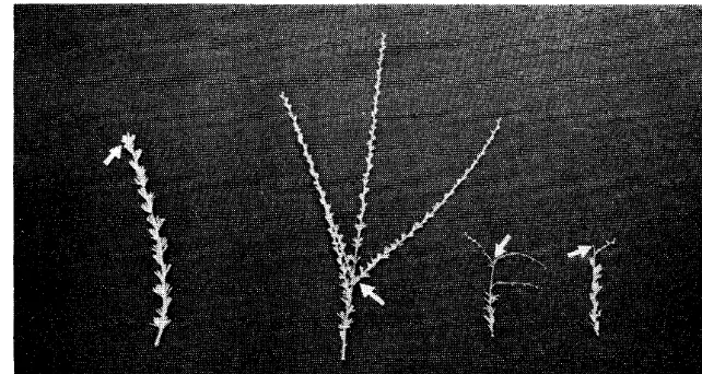
W. E. Howard, K. A. Wagnon, and J. R. Bentley Raie of Twig Elongation of Chamise
Thomas E. Bedell and Harold F. Heady The Effect of Clipping Leaves and Stems on Number
of Tillers, Herbage Weights, Roof Weighfs, and Food Reserves of Little Bluesfern
Donald A. Jameson and Donald L. Huss Flowering Sequence of a Local Flora
A. C. Budd and J. B. Campbell Effect of Burning and Clipping toln Growth of Native
Prairie in Iowa ____ ____ ____ ____ _____ _____ __________________ John H. Ehrenreich Technical Notes
110 116
122 127 133 A Useful Device for Laying out Forage Pro-
duction Plots ____ __________________________ ________ __ ____ ._..Sam H. Coleman The Effect of Burning on the Chemical Compo-
sition of Little Bluesfem
138
E. F. Smith and V. A. Young Nutritional Aspects of Wiregrass from West
Florida Sandhills..._... ____ _______ _____ . . . ..__...Frank W. Woods Book Reviews: Charles M. Russell: Cowboy Artist
(Russell); How fo Know Grasses (PohZ)..._.._._...__~_________~__~__ Currenf Liferafure..._...._____._~______~___________________~_~._._~____Lee A. Sharp Society Business: Report on fhe Twelfth Annual
Meeting: National Committees. .___.____ _ _____ _____________ _____ ________________ With the Sections... __________ _ ______. __ ____ _______ ____ _________.______________ News and Notes ____ ____________________________ ______ _____________________________..._.____ ____ ________
American
Society of Range Management
The American Society of Range Management was created in 1947 to foster advancement in the science and art of grazing land management, to promote progress in the conservation and greatest sustained use of forage and soil resources, to stimu- late discussion and understanding of scientific and practical range and pasture problems, to provide a medium for the exchange of ideas and facts among society members and with
allied technologists, and to encourage professional improvement of its members.
Persons shall be eligible for membership who are interested in or engaged in practicing range or pasture management or animal husbandry; administering grazing lands ; or teaching, or conducting research, or engaged in extension activities in range or pasture management or related subjects.
T
he JOURNAL OF RANGE MAN- AGEMENT, published b&monthly, is the official organ of the American Society of Range Management. The Society, however, assumes no responsibility for the statements and opinions expressed by authors and contributors.Off ice, Executive Secretary. Address all inquiries and correspondence including memberships, renewals, replacements of JOURNALS, etc., to Executive Secretary, American Society of Range Management, P.O. BOX 5041, Portland 13, Oregon. Dues. Membership dues should be sent to the Executive Secretary. The dues are
$8.00 per year including a subscrip- tion to the JOURNAL OF RANGE MAN- AGEMENT. Dues for student members are $4.00 per year, including the JOURNAL. All subscriptions mailed outside the North American continent and insular possessions of the U. S. are $8.50 per year. Subscrip- tions must be paid in advance. Remit by draft or check on U. S. banks in U. S. funds. Reprinting. The reprinting of articles or parts of articles published in the JOURNAL OF RANGE MANAGEMENT is author- ized on the express condition that full credit be given the JOURNAL and the author. The date of original publication must be shown with the credit line.
Post Office Entry. Second-class post- age paid at Portland, Oregon, and at ad- ditional offices.
Change of Address. Notices of change of address should be received by the Execu- tive Secretary one month before the date of issue on which the change is to take effect. Both the new and old addresses should be sent to the Executive Secretary, American Society of Range Management, P.O. Box 5041, Portland 13, Oregon.
Printers. The Nebraska Farmer Company, 1420 P Street, Lincoln, Nebraska.
Copyright 1959 by the American Society of Range Management.
OFFICERS OF THE SOCIETY
President:
DONALD F. HERVEY Colorado State University
Fort Collins, Colorado
Vice President: Executive Secretary:
FRED H. KENNEDY JOHN G. CLOUSTON
U. S. Forest Service P. 0. Box 5041
Albuquerque, N. Mex. Portland 13, Oregon
BOARD OF DIRECTORS
1957-59
KENNETH CONRAD E. WM. ANDERSON
Wray, Colorado Soil Conservation Service
Pendleton, Oregon 1958-60
JAMES L. FINLEY MELVIN S. MORRIS
Holbrook, Arizona University of Montana
Missoula, Montana
1959-61
JOHN CHOHLIS C. H. MCKINNON
Western Livestock Journal LK Ranches, Ltd.
Sacramento, California Calgary, Alberta
Past President:
ROBERT S. CAMPBELL U. S. Forest Service New Orleans 13, La.
HISTORIAN: A. A. BEETLE, Dept. of Agronomy, University of Wyoming, Laramie, Wyoming
JOURNAL OF RANGE MANAGEMENT EDITOR
WARREN C. WHITMAN
Department of Botany, North Dakota Agricultural College Fargo, North Dakota
EDITORIAL BOARD 1957-59
FRANK GYBERG E. J. WOOLFOLK Cornville, Arizona California Forest & Range
Experiment Station Berkeley 1, California 1958-60
ARNOLD HEERWAGEN W. R. HANSON Soil Conservation Service Eastern Rockies Forest 321 New Customs Building Conservation Board
Denver 2, Colorado Calgary, Alberta 1959-61
DONALD R. CORNELIUS JACK R. HARLAN ARS, California Forest & Range
Experiment Station
Journdl
of
Volume 12, Number 3 May, 1959RANGE MANAGEMENT
The Changing Picture in Hawaiian Range
Management
SHERWOOD GREENWELL
Rancher, Kealakekua, Territory of Hawaii
Cattle ranching is changing in Hawaii as it is all over the world. From native or wild cattle, poor grass, inadequate water supplies, and limited management, the cattle industry is becoming a highly specialized business. For example, on Kealakekua ranch, here are a few changes: native low-producing grasses, many acres of jungle, a little water, and almost wild cattle, demand- ing 10 to 15 acres per animal- month of grazing, to what we consider well-developed, fast- gaining long 2-year-olds, graz- ing on improved pastures carry- ing 1 animal per acre-month for a 5 or 6 month period, and 2% big steers per month for a like period on introduced grass and legume paddocks. We pump and store water at 400 to 800 pounds pressure in stages 6000 feet up Mauna Loa’s sides; carry on a weed, shrub and tree eradication program; intro- duce new bulls with fast-gaining ancestral histories on rotated and deferred grazing programs.
The jeep, truck, tractor, and jackhammer are fast replacing the donkey, horse, pick and shovel. But, in so doing, I am re- minded-looking world-wide- that probably more than three- fourths of our future grazing land will be in the tropics-land much like ours with varying soil, moisture, and elevation condi-
tions, whereas, today, most of our commercial grazing lands are in the temperate zones. Prob- ably that is the reason I weak- ened and agreed, when ap- proached by the Journal of Range Management, to tell about our operation here at Kealake- kua.
I was enthusiastic about the organization of our Soil Conser- vation District. We have one of the first cooperative agreements. SCS technicians have assisted us in soil surveys, grass and legume selections for pasture mixtures,
renovations, ground preparation, and seeding methods. We believe the District has been of assist- ance to us.
Early History
Cattle ranching in Hawaii has an interesting history. We have much of the traditions of long- time Hawaiian livestock business since cattle were first brought to the Islands by Captain Geo. Van- couver, an English navigator, in 1793. The original cattle came from California, and it was the descendants of these cattle, bred with Shorthorns, that were on the ranch when purchased by my grandfather in 1881, operated by him, followed by my father, and since his death, by me. In 1881, locally beef had little or no value. The Honolulu market was limited and transportation diffi- cult. Seven dollars and fifty cents was a good price in Hono- lulu for a big steer.
, I
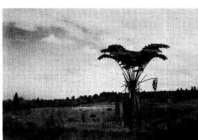
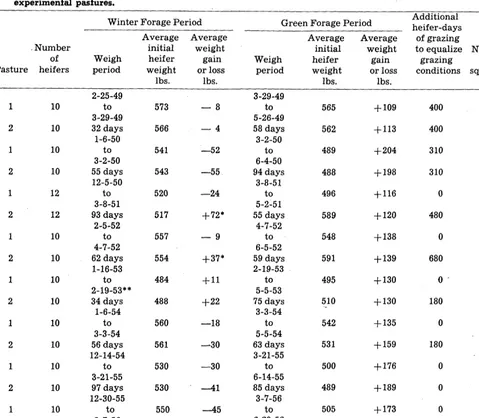
FIGURE 1. Representative Hawaiian pasture scene with old stone fence and tree fern against the horizon. (Photo Soil Conservation Service, USDA)
SHERWOOD GREENWELL
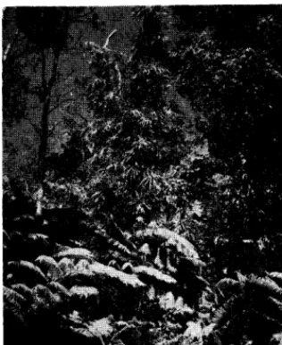
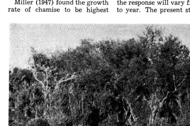
FIGURE 2. An example of the heavy tropical vegetation of ohai and fern trees with ieie vines climbing high on the trees. This vegetation must be removed when clearing for the development of new pastures.
(Photo Soil Conservation Service, USDA)
Consequently, dairies were the rule of the day, and our ranch, Kaelakekua, had four. Saint An- tone was located at the 2,300-foot level, Pawaena, Pauahi and Pa- paaloa, the uppermost, at an ele- vation of 5,100 feet, with an aver- age annual rainfall of 85-120 inches. Because of necessity, all were above the today valuable lower land, subject to seasonal droughts. These-lower areas had little-or no tropical forage plants to support livestock.
Grandfather had no fences other than boundary walls built of stones. The calves were kept at the dairies, so the cows usual- ly grazed within a mile of the dairy pens, returning each morn- ing to their calves and to be milked. The land farther out was a thick growth of trees up to 70 feet in height. The forests at these elevations were bedded with brush and a variety of ferns, some 40 feet high. This tangled tropical vegetation was so thick that the -sun seldom reached the ground. When it was very dry, or very cold, the ferns died back. It was during these periods that the cattle pushed their way into the jungled forest
for the leaves of the ieie (Frey-
cinetia arborea) and fern. Ponds and springs lasted only a few days beyond the rainy sea- son. There would be no water at the dairies. The livestock water or moisture came from the plants eaten by the cows.
Sherwood Greenwell was born in 1919 on the ranch where he is now manager, wi$h the ownership shared with his mother, his sister, and him- self. This dynamic young man is ac- tive not only in the management of the ranch but also in community en- terprises. He was one of the organ- izers of the Kona Soil Conservation District and is a director of the dis- trict. He is a charter member of the Kona Rotary Club and was its presi- dent at the age of 34. He was active in the Junior Chamber of Commerce of Konu until age eliminated him. He was elected to the Board. of County Supervisors for three terms.
During the years 1956-58 he was president of the Hawaii Cattlemen’s Association. He is a member of Ha- waii’s Territorial Cattlemen’s Coun- cil advisory committee to the Uni- versi@y of Hawaii, director of the Ha- waii Meat Company, and member of the advisory committee on noxious weeds to the Territorial Board of Agriculture and Forestry.
Mr. Greenwell has installed scales and weighs as many calves as he can at regular intervals, with the idea of selecting a breeding stock carrying $he ability for fast gains. His Zead-
ing cattle breed is a Hereford-Short- horn cross. He also maintains a small herd of registered Shorthorns and is experimenting with the Santa Ger- trudis.
The blazing summer suns, the howling northers, the drifts and banks of snow, and marrow- chilling, below-zero weather of the temperate zones, were more easily met and conquered by the early livestock operators than were the jungles. Now with new insecticides, breeding for tropical disease resistance, vaccines, shrub and tree eradication meth- ods, coupled with new grasses and legumes, a whole new world of opportunity is coming into be-
ing for the livestock man. With modern transportation facilities, an ever-increasing world popula- tion, and higher standards of liv- ing, I believe we livestock men, and our sons to follow, stand on the threshold of a great new opportunity.
First Improvement Work
Our success at the ranch has not been phenomenal, but’it has, like many other livestock opera- tions in Hawaii, been progres- sive, consistent and rewarding. As nearly as family history tells us, simultaneously with the start of the beef herd just prior to 1890, work was started toward the development of better ranges and pastures between elevations of 2,500 and 6,600 feet. After the seasonal foraging of the cattle into the forest, the seeds of a number of grasses were sown. As time went on, many acres of the former tree and shrub lands be- came more and more productive with, as we might say, a mini- mum of work. These so-called planted areas were given a help- ing hand by “weed men” sta- tioned at the former dairies, who ranged out into the grasslands, slashing out the ferns and pull- ing down the ever-invading guava tree.
The grasses planted during these early-years were those of the temperate zones-Kentucky bluegrass, orchard, and mesquite grass (Yorkshire fog) - all bf which did well under the cir- cumstances.
HAWAIIAN RANGE MANAGEMENT 101
FIGURE 3. Sherwood Greenwell (in white hat and white shirt) explaining his pasture renovation and management program to member of a Kona SCD tour. The kikuyu cut- tings are chopped and spread, a disk harrow covers the kikuyu, and then big trefoil and fertilizer are broadcast with a power machine. (Photo Soil Conservation Service, USDA)
many large trees are left for live- stock and grass protection from the intensely hot, dry days of winter. We have always tried to keep as many trees as possible without interfering with grass growth.
Some logging and wood cut- ting opened certain areas to a grass start. Also, some landown- ers burned over large areas so that grass might get a start. In- dications are that grandfather and father both recognized the value of trees and shrubs as soil and water preservatives, and al- lowed no wild burning of any kind. We try to keep certain water-producing areas in jungle.
Tropical Forages
The late twenties and early thirties brought the tropical for- ages to the ranch. Guinea and elephant grass (Pennisetum spur-
pureum) and ekoa (Leucaena gluuca), a bush legume, were planted in the hot, humid pas- ture areas below the 1,200-foot elevation, and kikuyu (Pennise-
turn clundestinum) from Africa, for almost any elevation provid- ing there is enough moisture. These plants have given us our highest producing pastures. It is on the lower pastures of guinea, elephant grass and ekoa during our summers (rainy season), when we have hot morning and rainy afternoons, that we get the best production. The carrying capacity runs to 2% head and up per acre-month when fattening steers. Kikuyu is our major feed on the upper pastures, fenced into paddocks for the different types of cattle. Kikuyu’s start was slow - hand sprigging just takes time and many, many hands.
In 1938 we had one of our real surprises during all the years of grass culture. Kikuyu plants were coming up everywhere. The grass was producing viable seed, and they were being spread from the droppings of the cattle. This is unusual, and the first time, we have been told, it has produced viable seeds outside of
its native Africa. Kikuyu pro- duces long runners, going away out, covering completely loose rocks and bare surface stone and soil.
This gives a false impression of the ground below it and has pro- duced some rather amazing epi- sodes. A few years ago the U. S. Soil Conservation Service was making their soil survey of the ranch. One of the men testing the depth of the soil, held his probe high above his head ready to force it deep into the thick grass at his feet only to have it stop short after going only an inch or two below the top of the grass. I don’t know when I have seen a more surprised expres- sion. This type of lava is known as pahoehoe and looks a great deal like the burnt remains of cherry pie filling on the oven floor.
Lava Creates Problems
This lava also produces other problems. Today the fastest and cheapest fence to build is one where a-inch holes are drilled for studded iron fence posts with compressed air jackhammers and the posts then set with cement. The rock is so hard that all gate post‘ holes must be made with paving breakers or blasted. Local woods, koa
(Acacia
kou),
ohia (Metrosideros collinu), and ma- mani(Sophoru
chrysophyZZu),
are used in some areas and are practical for different purposes. Koa, when dry, makes a very good post, lasting some 10 years in most areas and is our best for gates and bar pens. Ohia, when green, is easily worked and is. best for pole sheds or covered areas. This wood when dry is very hard, and nails set in green- wood must be cut out when the wood dries.
102 SHERWOOD GREENWELL
tion Service, USDA)
material. With this in mind, 550 Sequoia sempervirens, the red- wood most used for lumber, have been planted to produce future redwood needs.
Water run-off is not the prob- lem it could be on this steep land because of the porosity of the lava. Many holes and cracks on the surface open into lava tubes, from 2 to 12 feet in diameter be- low, which act as natural storm drains. In two areas these nat- ural drainage ways have been used to great advantage in con- trolling storm waters, coming at times as heavily as 9 inches with- in a 3-hour period. Both loca- tions have diversion dams of soil and rock, planted with eucalyp- tus trees to give added strength to divert the storm waters into the natural drains, protecting bower pastures and coffee farms
from damage.
Clearing and Seeding
Clearing land today is done mostly with a large bulldozer taking off the heavy cover of trees and fern, with later follow- ups of basic applications of 2,4-D, or 2,4,5-T, depending upon the weeds encountered. Planting of these areas is done after the ground has been rolled with a
servation Service, USDA)
5%-ton surplus sugar mill roller pulled behind the- tractor. This smooths the ground by forcing loose stones below the surface. Kikuyu grass cuttings are then made by putting the grass run- ners through a feed chopper. They are distributed by means of a modified lime spreader and lightly disked into the soil. This is followed, when the cuttings develop root, with 100 pounds of Ammo-phos 21-48 fertilizer and
2% pounds of big trefoil (Lotus uliginosus) per acre. This com- pletes the present planting prac- tice, which has prove,n very sat- isfactory. Fertilizers are used to maintain the legume-grass bal- ance - phosphates should the grass become dominant, or urea if the legumes take over.
The best pastures are below the 1,200-foot level, where there are normally 40 inches of rain a year, coming mostly during the
FIGURE 6. The catchment tanks at Pauahi under galvanized steel roofs, which gather the water during the rainy season and carry it to the tanks which are covered by the roofs.
HAWAIIAN RANGE MANAGEMENT 103
summer, our wet season, and then in the late afternoons. Very hot mornings of about 80” with the preceding evening’s rain, give ideal growing conditions. And so during the normal sum- mers we have carrying capacities of 2% head per acre.
Solving the Water Problem
Water has always been a prob- lem, as our new volcanic ground is so porous that no water is held in underground dykes or seams producing springs. Pond and seepage areas dry as soon as the rains stop, so all water gathered in this manner and on corrugated iron roofs must be stored in wood or steel tanks. In the past, during the winters, the cattle were rationed water, only a couple of gallons apiece, and
then watered again two days later. This meant that they were never satisfied and remained around the pens from one water- ing to the next, not going far to eat. This was our bad season. We just expected to lose at least 20 cows each season.
In 1953, to augment the rain- water and to guarantee an ade- quate supply of water, a pump- ing system made up of four high- pressure pumps was put into service. The system lifted water of 130 grains chloride from sea level, the only sure source of water, to Papaaloa, a camp 9% miles up the slope of Mauna Loa at an elevation of 5,000 feet. This has given us an unlimited sup- ply of drinking water for the cat- tle and has cut our season losses to zero. The pressures vary from
400 to 800 pounds. This year the line is being extended another 2% miles to the 6,000-foot eleva- tion, and through its distribution, we will better utilize the higher elevation pastures.
Future Prospects
Looking to the future, a sys- tem of rotation pastures are on the drawing board. Two areas are already in the planning stage, one incorporating six 17%- acre lots with a central water and feed pen, and another of four 75-acre paddocks. These will be high production pastures where fertilizer will play an im- portant part. Through the use of new legumes, fertilizer, smaller pastures, and, rotation practices, we should, within the next five years, double our output.
Program for:
SUMMER FIELD MEETING
American Society of Range Management
and
The Colorado Section
Gunnison, Colorado, July 30-Aug. 1, 1959
July 30 (Thursday):
Board of Directors Meeting
Banquet for Society members and guests
Evening program of slide lectures on areas to be visited
July 31 (Friday):
Trip to Black Mesa Experiment Station
August 1 (Saturday):
Half-day field trip in the Gunnison area to inspect Woods ,Gulch Pilot Project, range reseeding, sagebrush eradication, and other improvement work
Requests for hotel and motel reservations should be addressed to:
Vegetational Composition
Two Natural Relict Areas
and Ground Cover of
and Their Associated
Grazed Areas in the Red Desert of Wyoming1
ROBERT MARQUISS AND ROBERT LANG
Department of Agronomy, College of Agriculture, Uni- versity of Wyoming, Laramie, Wyoming
The Red Desert of Wyoming is a
valuable
resource because it furnishes winter grazing for a high percentage of the state’s sheep. Consequently, proper grazing management of this and other winter range areas is a problem continually confronting the range manager.The early stages of range de- terioration are difficult to detect without a guide to the vegeta- tional composition and produc- tion potential to use as a basis for comparison. Natural barriers to grazing resulting in relict areas are few. When they can be found, they are invaluable for the determination of composi- tion and production potential of similar range sites.
Two natural relict areas occur- ring in Wyoming’s Red Desert were utilized in this study in an attempt to determine changes in vegetation which may be attrib- uted to grazing on the shallow- soil range sites common to the area.
Previous Studies
The range condition class method of study is commonly used in range analysis. It is based upon comparison of relict and grazed areas on the basis of vegetational composition, Beetle
(1952)) Gardner (1950)) Whit-
1 Published with the approval of the Director, Wyoming Agricultural Experiment Station, as Journal Paper No. 108. Portions of qhe ma- terial in this paper were used by
the senior author in partial fuZfiZZ-
ment of the requirements for the Master of Science degree.
field and Buetner (1938)) and others have used the method as a key to both the past and future in recording functions and changes of plant communities.
Clements (1934) described a relict in an ecological sense, as “a community or fragment of one that has survived some im- portant change, often to become in appearance an integral part of the existing vegetation.” He further describes a relict as pos- sessing evidence of “two indica- tor values of the first impor- tance. These relate to the causes concerned on the one hand and to the original vegetation and its changes on the other. The former may be climatic, edaphic, or human, each exhibiting a more or less distinctive impress.” The relict method is a key to both the past and the future and places proper emphasis upon the measurement and record of com- munity functions and changes by means of quadrats and exclo- sures.
In areas of high precipitation and mature soils, where vegeta- tional composition changes are relatively rapid, exclosures with
14.07 Acres
FIGURE 1. Scale diagram and area of the relict areas studied in Sweetwater County, a physical distance of about 50 miles.
104
short relict histories have been used to determine trends of vege- tational changes. In a vegetation survey of the Fort Worth Prairie Dyksterhuis (1946) selected re- lict areas which had not been grazed for at least five years or longer, giving emphasis to one (
area which had not been grazed by domestic livestock since barbed wire became generally available. He did not consider any land that had been culti- vated or subjected to other types of severe disturbance which leave a relative permanent im- press on soil or vegetation.
The earliest records of the vegetational composition of the Red Desert area where this study was conducted were made by Aven Nelson in 1897 (Nelson, 1898). The main objective of his survey was not merely to list plant species, but also to evalu- ate the forage value of the region.
The findings of Nelson were confirmed by Vass and Lang (1938). In counts of living and dead plants and reproduction of four shrubby species, they found that with few exceptions there was sufficient reproduction to replace the plants which had died in 1936. A comparison of the grazing capacity of the ma- jor vegetation type between a controlled grazing area, as repre- sented by the Rock Springs Grazing Association lease, with a non-controlled grazing area, as represented by the land sur- rounding the lease, showed no significant difference.
relatively flat summits of the two natural Wyoming. The two areas are separated by
BLACK ROCK BUTTE --
VEGETATION OF RELICT AND GRAZED AREAS 105
Table 1. Monthly and annual precipitation in inches and annual departure from average for fhe five years of study”
Year
Annual Departure Jan. Feb. Mar. Apr. May June July Aug. Sept. Oct. Nov. Dec. Precipi- from 20-
tation year mean 1937 -67 1.26 .72 1.01 .73 1.94 3.00 .62 .38 .71 .93 .70 12.67 +S.Ol 1938 .16 .38 1.24 1.68 1.64 .56 1.42 1.24 1.00 2.23 .54 .09 12.18 +5.52 1939 .55 .82 .17 .98 .65 .33 .45 .03 .84 .74 .oo .07 5.63 -1.03 1940 1.12 .65 .86 .64 .78 .08 .24 .18 1.57 .74 .90 .50 8.26 +1.60 1956 .38 .14 .05 .94 2.20 .Ol .27 .56 .35 1.18 .70 .36 7.14 + .48 20-year mean
(1937-1956)
* Average precipitation data from the Farson and Rock Springs weather stations.
6.66
The Study Area
Two relatively flat topped buttes2 located about 50 miles apart in the northwestern quar- ter of Sweetwater County, Wyo- ming, provided the natural relict areas for this study. These buttes, locally known as Black Rock Butte and Pilot Butte, have high perpendicular sides, and their tops could not possibly have been grazed within historic time by any herbivorous animals other than rodents. The grazed areas studied in conjunction with the butte tops were located near the level base of each butte, but still within the shallow-soil range
site common to the relict areas. The vegetation of both the grazed and relict areas studied consisted mainly of desert shrubs as dominants and perennial grasses as subdominants. Vari- ous perennial and annual forbs were evident from year to year depending on climatic conditions.
The dominant species on both relict and grazed areas was big sagebrush (Artemisia triden- tutu). Other common browse species were: winterf at (Euroti
Zunata), spiny hopsage (Grayia
spinosa), shadscale (A trip 1 ex confertifoliu), low rabbitbrush
(Chrysothamnus viscidiflorus pumilus) bud sagebrush (Artem- isia spinescens), and Gardner saltbush (Atriplex gardneri).
Grasses most common to this
2 Black Rock Butte is located in Sec. 24, T. 22 N., R. 101 W., and Pilot Butte is located in Sec. 9, T. 19 N., R. 106 W.
desert range area were: mutton blue grass (Pou #endZeriam), bottlebrush squirreltail @tan-
ion hystrix) Indian ricegrass
(Oryzopsis hymenoides), blue- bunch wheatgrass (Agropyron
spicutum), needle - and - thread, and thickspike wheatgrass (Ag- ropyron dasystachyum).
Although a great variety of forbs were listed from the study plots, those most frequently en- countered were : Hoods phlox (Phlox hoodii), cushion eriogo- num (Eriogonum ovulifolium),
Hooker sandwort (Arenaria hookeri), slenderbush eriogo- num (Eriogonum microthecum),
stemless goldenweed (Haplopup- pus acaulis), fringed sagebrush
(Artemisia frigida), arrowleaf balsamroot (Bulsumorrhiza sag- ittata), stickseed (LappuZu spp.), bluebells (Mertensiu oblongifo- Zia), and Fremont penstemon
(Penstemon fremontii).
A cool climate and low precipi- tation are characteristic of the Red Desert region where this study was conducted. Average annual precipitation is less than 10 inches and much of the ef- fective moisture comes during March, April, and May in the form of snow and light showers. Generally little precipitation oc-
The elevation of Pilot Butte is 7,923 feet, and it rises some 450 feet above the surrounding area. Black Rock Butte rises 658 feet above the sourrounding area to an elevation of 7,558 feet. The size and the outlines of the rela- tively level tops of both buttes are shown in Figure 1.
curs during the summer months, although both 1937 and 1939 were years with abundant sum- mer moisture. (Table 1).
Meihods of Study
The vegetational composition and ground cover of the relicts and surrounding grazed land were studied in June each year by the point-observation plot method as described by Stewart and Hutchings (1936). These studies were conducted in 1937, 1938, 1939, 1940 and 1956. Ten circular plots, each 100 square- feet in area, were studied on
each location each year. On the summits of each butte, plots were spaced at random but not at the very edge of the butte. The randomly located plots on the grazed areas were near the level base of the butte but con- fined to the shallow soil range site similar to that of the summit.
ROBERT MARQUISS AND ROBERT LANG
Ll
Relict Grazed
Pilot Butte
Relict Grazed
Black Rock Butte
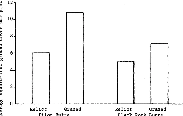
FIGURE 2. Average square-foot ground cover per plot for the Pilot Butte and Black Rock Butte relict and grazed areas.
tween the soil of the relict areas
and that of the associated grazed
areas.
Results
Total Ground CoverTotal ground cover was greater
on each grazed area than on its
associated relict. The grazed area
surrounding Pilot Butte had the
greatest total ground cover with
a five-year average of 10.54 per-
cent, compared with 6.02 percent
on the summit of the butte. The
Black Rock Butte grazed area av-
eraged 6.97 percent total ground
cover compared with the top of
the butte which averaged 4.84
percent. The average
total
ground cover per plot on each lo-
cation is shown in Figure 2, and
the average percentage compo-
sition by vegetational groups for
these same areas is shown in
Figure 3.
The average total ground cover
per plot on the top of Pilot Butte
decreased for each of the five
years studied while on Black
Rock Butte it decreased from
1937 to 1940 and increased again
by 1956 to about the five-year
average. The two grazed areas
reacted somewhat differently
each year from the two relict
areas, but the reactions of the
grazed areas were similar to each
other. Each grazed area in-
creased in total ground cover in
1938 over 1937, decreased in the
following 2 years to a low in
1940, but again increased slightly
by 1956. These total ground cover
fluctuations occurring
on the
grazed areas were similar to
those of the precipitation aver-
ages of March through June of
the same 5 years. General views
of the vegetation on the two
relict areas in June 1956 are
shown in Figures 4 and 5.
Separate analyses
of the
ground cover were made of the
four most widely distributed
species of major
importance
within the grazed and relict
areas. The species with the
greatest ground cover, big sage-
. F
brush, contributed 34 percent of
the total vegetational composi-
tion on the relict plots and 54
percent on the grazed plots.
These figures would indicate
that big sagebrush is an increaser
on these shallow soil range sites.
Greatest variation in ground
cover of big sagebrush within
the five-year period was from
3.87 percent in 1938 to 2.64 per-
cent in 1940. When these data
pertaining to ground cover of
big sagebrush were analyzed sta-
tistically, differences
between
buttes, locations, years and all of
the interactions between these
factors were highly significant.
The ground cover of winterfat
was found to be considerably
lower on the grazed areas than
on the relict areas. Black Rock
Butte had the greatest ground
cover of this species, with an av-
erage of 0.60 square-foot per plot,
while the grazed area surround-
ing the butte averaged only 0.04
square-foot per plot. Winterf at
contributed 12 percent of the to-
tal ground cover on the relict
compared to 0.57 percent on the
grazed land; under these condi-
tions of shallow-soil range site,
it would be considered a de-
creaser. Pilot Butte had an av-
erage ground cover of 0.18
square-foot of winterfat per plot,
while the grazed area surround-
ing the butte averaged
0.12
square-foot per plot. It contrib-
u
5
z
0El
Shrubs and semi-shrubsq
Grass and grass-likeq
Forb speciesRelict Grazed Relict Grazed
Pilot Butte Black Rock Butte
VEGETATION OF RELICT AND GRAZED AREAS 107
uted 3 percent of the total ground cover on Pilot Butte and only 1 percent on the grazed land. These differences in ground cover of winterfat between buttes, between locations, and among years were highly signifi- cant.
The greatest variation in the ground cover of Indian ricegrass was between the Pilot Butte re- gion and the Black Rock Butte region. Little difference existed in ground cover of this species between each relict area and its associated grazed area, and vari- ations among years was small. Differences between the buttes were significant at the 0.01 level. Differences between relict and grazed areas (locations), among years, and interactions of these factors were non-significant.
Needle-and-thread was com- mon on the two grazed areas and contributed about the same ground cover as did Indian rice- grass. It was less common on the two associated relict areas. Black Rock Butte had an average of 0.06 square-foot ground cover per plot, while its surrounding area had 0.20 percent average ground cover of this species. Pilot Butte had only an average of 0.01 square-foot ground cover per plot and its associated grazed area had 0.09 percent. Differ- ences among years, between lo- cations, and between buttes were highly significant. From these data it appears that needle-and- thread would be classified as an increaser under grazing.
Three species, shadscale, Gard- ner saltbush, and bud sagebrush, were present on Black Rock Butte and the surrounding grazed area, but were not pres- ent in the Pilot Butte region. Actually shadscale was the dom- inant species on the top of Black Rock Butte and big sagebrush was the subdominant. Average ground cover of shadscale was 1.41 percent on the Black Rock Butte relict and only 0.14 percent on the grazed area surrounding the butte.
FIGURE 4. Typical vegetation on the Pilot Butte relict area. Photo taken in June 1956.
Frequency of Specific Occurrence
There were only 9 species of the total of 50 which occurred on both locations of Pilot Butte and Black Rock Butte. Big sagebrush occurred with 60 percent fre- quency on the summit of Black Rock Butte and 96 percent on the grazed land of this area. The re- maining 8 species found on both locations of the two butte regions consisted of one semi-shrub, five grasses, and two forbs.
Forbs varied the most between the two locations (relict and grazed). Black Rock Butte area had 6 species of forbs occurring on the relict plots and 14 were recorded on the grazed area around this butte. Pilot Butte had 19 species of forbs and its surrounding grazed area had 31. Wild onion (Allium textile)
was present only on Pilot Butte, and scarlet globemallow (Sphae- ralcea coccinea) was present only on Black Rock Butte. These were the only two species found to occur on the relict and not on the grazed plots.
One shrub, gray horsebrush (Tetrudymiu cunescens), three grasses, thickspike wheatgrass, slender wheatgrass (A. truchy- cuulum), and subalpine needle- grass (Stipu columbiunu), one sedge (Curex eleochuris), and 13 species of forbs occurred on the two grazed areas studied but not
on their associated relicts. These species were generally of less -than 10 percent frequency.
All species present on the two buttes and the two grazed areas which had an average frequency of 10 percent or more are listed in Table 2.
Plant Counts of Four Species
Counts of living plants (other than seedlings), dead plants, and seedlings were made of big sage- brush, winterfat, shadscale, and Gardner saltbush. Only two species, big sagebrush and win- terfat were frequent on both Black Rock Butte, Pilot Butte, and their adjacent grazed areas. The average number of living plants of big sagebrush per plot on Black Rock Butte was 2.82. This compared with 6.80 living plants per plot on the surround- ing grazed land. Pilot Butte av- eraged 12.92 plants per plot and its surrounding grazed area aver- aged 17.72. The number of living plants increased from an average of 5.40 per plot in 1937 to 15.70 per plot in 1956 on the two relict areas. The number of living plants on the grazed areas in- creased from an average of 11.75 per plot in 1937 to 19.55 per plot in 1956. These differences were highly significant.
108 ROBERT MARQUISS AND ROBERT LANG
Table 2. Percentage frequency of plant species occuring on fwo relict and two grazed areas in Sweefwafer County, Wyoming. (Species with average frequency of 10 percent or more.)
Species Pilot Butte Black Rock Butte %f Avg. All *ifi’ Relict Grazed Relict Grazed Relict Grazed Areas Artemisia tridentata ___________________. 100 100 60 96
Poa jendleriana __ ___________ ______.______._ 88 92 72 80
Sitanion hystrix __ _____ _ . .._ _._____________. 72 80 78 76 Oryzopsis hymenoides ______________.. 52 44 92 88 Phlox hoodii __ _____.____. __ .___ ______ ______ ___ 88 90 20 62 Agropyron spicatum ___________ ______ __ 96 86 42 6 Eurotia lanata .___ ____._.____ _________ ____ _. 80 40 80 8 Eriogonum ovalijolium ______________ 80 90 ___. 26 Arenaria hookeri ___ _____ __________________ 100 30 48 8 Stipa comata ____ ___ _____.______ ________ _____ __ 8 48 34 48 Grayia spinosa ____ ____ ______________________ 56 ______ 2 62 Atriplex conjertijolia _.___ _ ____ ________ ______ ____._ 92 26 Chrysothamnus viscidijlorus
pumilus _.__ _ ____ ______ ________ _________ ____ __ 6 74 ____ 30 Artemisia spinescens.. ______ ________ __ ______ ______ 86 14 Eriogonum microthecum ____________ 2 88 ____ 2 Haplopappus acaulis _____ ____ ___________ 12 74 2 ____ Agropyron dasystachym _ ___________ __.___ 42 ____ 42 Artemisia jrigida __.________ ________ ____ ___ 66 16 ____ ____ Balsamorrhiza sagittata -____________ 2 70 ____ ____ Lappula spp. _ ____ ___ ________ __._______ ________ 10 38 ____ 24 Mertensia obtongijolia ._________ ____ __ 2 42 ____ ____ Atriplex gardneri _________ ____ ___________ ._____ ____ __ 32 8 Penstemon jremontii ___.________________ 2 34 ____ 4
80 98 89.0
80 86 83.0 75 78 76.5 72 66 69.0 54 76 65.0 69 46 57.5 80 24 52.0 40 58 49.0 74 19 46.5 21 48 34.5 29 31 30.0 46 13 29.5 3 52 27.5 43 7 25.0 1 45 23.0 7 37 22.0 ____ 42 21.0 33 8 20.5 1 35 18.0 5 31 18.0 1 21 11.0 16 4 10.0 1 19 10.0
among years. The number of dead plants on the relict areas averaged 0.15 per plot in 1940 and 2.0 per plot in 1956. Grazed areas had a higher percentage of dead plants than their associated relict areas.
Variations in the number of big sagebrush seedlings were high among years, between buttes, and between locations. Pilot Butte had the greatest av- erage number with 24.26 seed- lings per plot. Its associated grazed area averaged 15.62 seed- lings per plot. High variations, but in the reverse order, oc- curred in the Black Rock Butte area, Seedling numbers aver- aged only 1.18 per plot on the relict and 12.92 per plot on the grazed area. The average num- ber of seedlings for both areas (including the relict and grazed lands) was greatest in 1938 (33.65 per plot) and 1939 (20.92) and averaged 13.50 per 100 square feet for the 5 years of study. There were no seedlings in any of the plots in 1956. When these
data were analyzed statistically there was no significant differ- ence between locations. How- ever, differences between buttes, years, and the interaction be- tween buttes and locations were significantly different at the 0.01 level.
Counts of winterfat showed the greatest variation between locations. The number of living plants was less on each grazed area than on the non-grazed re- licts. Differences in numbers of plants varied considerably less than the variations in ground cover for this species on the dif- ferent buttes. The Black Rock Butte relict area had the greatest average of living winterfat plants per plot (5.86) and the Pilot Butte grazed area had the lowest (1.98). Variations among years ranged from an average of 5.62 living plants per plot in 1939 to 1.95 in 1940. Differences be- tween locations were significant
at the 0.05 level, and all other differences were non-significant.
The number of dead winterfat
plants averaged only 1.50 per plot on the four locations. There were fewer dead plants on the grazed than on the relict areas. Variations among years, how- ever, were greater than among locations, with an average from 0.32 dead plants per plot in 1939 to no dead plants recorded in 1956. Differences among years were significant at the 0.01 level. Other variations were not sig- nificantly different.
Seedling counts of winterfat showed no signif icant difference between buttes, between loca- tions, or among years.
The average number of living plants of shadscale on Black Rock Butte was 7.18 per plot. Its associated grazed area had an av- erage of 0.76 living plants per plot. The greatest number of seedlings on the relict areas was recorded in 1938 with an average of 1.50 per plot. Average number of seedlings over the 5 years studied was only 0.04 per plot. This species did not occur in the Pilot Butte region.
Soil Analyses
Soil samples were taken from grazed lands of shallow-soil range sites adjoining the relict areas for comparison with soil samples removed from the re- licts. These were analyzed for possible factors affecting differ- ences in vegetational composi- tion and ground cover between the two locations.
.
A mechanical analysis for tex- ture showed that the soil from the grazed areas near Pilot Butte and Black Rock Butte contained a higher percentage of sand and a lower percentage of clay than their associated relict areas. Tex- ture class changed from clay loam on Pilot Butte to loam on the associated land, and from clay loam on Black Rock Butte to sandy clay loam on the sur- rounding grazed land.
VEGETATION OF RELICT AND GRAZED AREAS 109
FIGURE 5. A view of the northwestern part of the Black Rock Butte relict area showing the tall shrubby vegetation common to this part of the butte. Photo taken in June 1956.
relict areas, was even lower in samples from the grazed. Air- water permeability tests indicate all soils sampled to be stable in structure.
to the shrubby vegetation and primarily to big sagebrush. How- ever, ground cover of forbs also varied considerably on some of the grazed plots.
Conclusions
Grazing has apparently caused a shift in vegetational composi- tion on the shallow soil sites of Sweetwater County, Wyoming, as evidenced by the greater num- ber of forb species present on grazed areas, greater percentage of ground cover made up of shrubs, and smaller amounts of grass when compared with close- ly associated relicts.
Spring rainfall has consider- able effect upon establishment of big sagebrush seedlings. This factor does not operate alone, as no seedlings were evident in 1956, which was a year with more spring precipitation than occurred in 1939 and 1940 when relatively large number of seed- lings were recorded.
The use of relict areas as a basis for judging grazed range lands is a common practice. However, this study shows a wide variation in the vegetation- al composition and ground cover between relicts of similar shal- low soil sites separated by ap- proximately 50 miles. This fact emphasizes the importance of using many relicts or protected areas as a basis for judging the condition of grazed lands.
Under the conditions of this study it must be concluded that big sagebrush and needle-and- thread are increasers, while winterfat is a decreaser under grazing. The reaction of other species to grazing pressure was not sufficiently definite for ac- curate classification as increasers or decreasers.
Summary
Ground-cover fluctuations on both relict and grazed areas were high among years. Fluctuations in this factor were greater on the grazed areas than on the relicts for different years. These ground-cover changes among years may be largely attributed
Black Rock Butte and Pilot Butte in Sweetwater County, Wyoming, were studied as true natural relict areas to compare vegetational composition and ground cover with that of grazed land of similar rangesite char- acteristics surrounding these buttes. This is an arid area used primarily for winter grazing by sheep.
Average total ground cover
was greater on both grazed areas studied than on their associated relicts. Ground cover of shrubs and semi-shrubs on the grazed land was the main factor ac- counting for this greater total. Changes in ground cover were greater on the grazed areas than on the relicts for the years of extremes in precipitation.
Shrubs, semi-shrubs, and forbs contributed a greater percent- age, and grass and grass-like spe- cies made up a smaller percent- age of the total ground cover on the grazed area than on the relict areas.
One shrub, three grasses, one sedge, and thirteen forb species occurred on plots of the grazed areas, but were not found on the relict plots. Two forb species oc- curred on the relicts but not on the associated grazed land.
Soil samples analyzed from each of the relict areas and from the grazed areas varied only slightly between the two loca- tions.
LITERATURE CITED
BEETLE, ALAN A. 1952. A relict area
on the Wyoming shortgrass plains. Jour. Range Mangt. 5: 141-143. CLEMENTS, FREDERIC E. 1934. The re-
lict method in dynamic ecology. Ecology 22: 39-68.
DYKSTERHUIS, E. J. 1946. The vege- tation of the Fort Worth prairie. Ecol. Mono. 16: 12-15.
GARDNER, J. L. 1950. Effects of thirty years of protection from grazing in desert grassland. Ecology 31: 44-50. NELSON, AVEN. 1898. The Red Desert of Wyoming and its forage re- sources. U. S. Dept. of Agr. Bul. 13. Agros. 33. 72 pp.
STEWART, GEORGE, AND S. S. HUTCH- INGS. 1936. The point observation plot (square foot density) method of vegetation survey. Jour. Am.
Sot. Agron. 28: 714-722.
VASS, A. F. AND ROBERT L. LANG. 1938. Vegetative composition, den- sity, grazing capacity, and grazing land values in the Red Desert area. Wyo. Agr. Exp. Sta. Bul. 229. 72 PP.
Competition Between Ground Squirrels and
Cattle for Range Forage
W. E. HOWARD, K. A. WAGNON, AND J. R. BENTLEY
Specialist, Field Station Administration, University of California, Davis; Specialist in Animal Husbandry, De- partment of Animal Husbandry, University of California, Davis; and Range Conservationist, California Forest and Range Experiment Station’, Forest Service, U. S. Depart- ment of Agriculture, Berkeley, California
“On open range and in pasture lands ground squirrels (Citellus) feed largely on filaree and bur clover, two of the most valuable forage plants in California, and become serious competition for subsistence against the flocks and herds upon which man de- pends for his own support”
(Grinnell and Dixon, 1918). Even though ground-squirrel populations are no longer as dense as in former years, they are still sufficiently numerous to be of major concern locally. The degree to which these squirrels compete with cattle for range forage is still a question among livestock operators and range technicians.
The purpose of this study was to determine the role of ground squirrels (Citellus beecheyi) on range land by expanding the ex- perimental approach from cages and field enclosures to a pasture scale. The experiment was de- signed to see if rodent utilization of green forage in the winter was great enough to measure in changes in cattle weights.
Grinnell and Dixon (1918) cal- culated that 200 ground squirrels “consume” the same amount of range forage as a l,OOO-pound steer. Fitch and Bentley (1949)) studying the effects of range rodents on forage cover at the San Joaquin Experimental
The California Forest and Range Experimenti Station is maintained at Berkeley in cooperation with the University 0 j California.
Range, found that 6 male ground squirrels confined to a half-acre enclosure decreased potential forage yield by 529 pounds - more than 10 times the amount the squirrels may. have eaten. The results also suggested that natural field populations of ground squirrels, pocket gophers (Thomomys), and kangaroo rats
(Dipodomys) in some pastures of the station might be reducing the annual herbaceous forage crop by more than one-third.
Fitch (1947 and 1948)) study- ing the seasonal feeding habits of ground squirrels, found this rodent to be highly selective in its diet, feeding for part of the year exclusively on forage plants that Wagnon et al. (1942) had shown were also being grazed at that season by cattle. These studies showed that both the ground squirrels and the cattle began feeding on the new annual plants soon after seed germina- tion and continued through the winter months, while the plants were growing slowly. It is dur- ing this period of inadequate for- age growth (Bentley and Talbot, 1951) that ground-squirrel com- petition with livestock for range forage is most critical. A surplus of forage for both rodents and livestock is usually available after vegetation starts its rapid spring growth.
Experimenfal Area
The study was conducted at the San Joaquin Experimental Range, in the Sierra Nevada
foothills in Madera County, Cali- fornia, at an elevation of about 1,150 feet. Topography is rolling, with generally southwesterly ex- posures. Soils are of granitic
origin, and rock outcrops are numerous. The area is in the woodland-grass type, with an open stand of trees and shrubs and a herbaceous cover of annual grasses and forbs. Interior live- oak (Quercus wislizenii), blue oak (Q. douglasii), Digger pine
(Pinus sabiniana), and wedge- leaf ceanothus (Ceanothus cune- atus) are the dominant trees and shrubs. More detailed descrip- tions of the Experimental Range are presented by Talbot, Nelson, and Storie (1942)) and Bentley and Talbot (1951).
Procedures
One pair of pastures was used, with a reversal of treatment to help rule out site differences be- tween pastures. The plan was to use 2 years for pasture calibra- tion, then eliminate the squirrels from one pasture for at least 2 years, and then let the squirrels come back on the poisoned pas- ture and remove them from the other pasture for several more years.
Pasiure
Pasture 1 (formerly part of pasture 8s) and Pasture 2 (for- merly part of pasture 3, Bentley and Talbot, 1951) were estab- lished for this study in 1948. The two pastures were selected as areas with satisfactory popula- tions of ground squirrels and similar plant covers containing considerable broad-leaved fila- rees (Erodium spp.) (Wagnon and Biswell, 1947). The pastures were separated by about 1 mile, but equally accessible to stock- weighing facilities.
The two pastures varied in site qualities, but an attempt was made to make them equal in grazing capacity. Because Pas- ture 1 showed greater capacity during the first year of calibra- tion, its acreage was reduced in 1949, from 40.40 to 31.53 acres.
COMPETITION
The size of Pasture 2 was held at 48.40 acres throughout the ex- periment. Acreages of the vari- ous site classes, total areas, and grazable area for each pasture
(after size of Pasture 1 was re- duced) were:
Pasture Pasture
1 2
Acres Acres
~ ~
Swale 1.07 2.76
Open, rolling slope 9.79 1.11 Rocky, brushy slope 20.67 44.53 Total area 31.53 48.40 Grazable area 28.15 41.30
The two pastures differed in past grazing treatment. Pasture 1 had formerly been grazed pri- marily during the dry-forage and winter-forage periods, at a mod- erate stocking rate. For 12 years Pasture 2 had been grazed dur- ing the green forage period, at a heavy stocking rate.
Rodent Census and Poisoning
A census of ground squirrels and certain small rodents was maintained in both pastures each year of the study. The adult breeding population of ground squirrels was censused each year from January to March, before appearance of the young. Some censusing was also done in the summer and fall. During the 2 years of pasture calibration, when squirrels were in both pas- tures, an attempt was made to count the squirrels by stationing oneself in the pasture and ob- serving with field glasses. To facilitate counts, numbers about 12 inches high were painted on rocks adjacent to each colony. Later a plan of live trapping, which was more efficient and gave precise counts was adopted. Each trapped squirrel was marked by cutting off the tip of the tail and clipping most of the hair from the rest of the tail. The few that were not caught and marked were easily seen and counted while walking through the pasture. The Lincoln Index was also used with trapped ani- mals. It did not give reliable population density figures, be- cause of the large number of dispersals of squirrels.
BETWEEN GROUND SQUIRRELS AND CATTLE 111
In the fall of 1950 the ground squirrels were poisoned in Pas- ture 2 and in a l,OOO-foot-wide buffer strip. The Madera County Agricultural Commissioner did the control work, using oat groats and Compound 1080 (sodi- um fluoroacetate) . The pasture was kept free of squirrels in the 1950-51 and 1951-52 seasons by frequent checking, and addition- al local poisoning where needed. After the ground squirrels were kept out of Pasture 2 for two seasons, the pasture poisoning treatment was reversed. Pasture 1 was poisoned in the fall of 1952 and kept free of ground squirrels for the next 4 years, in the manner previously followed in Pasture 2. In an attempt to ex- pedite reestablishment of ground squirrels in Pasture 2, 80 indi- viduals were live trapped in Pas- ture 1 and released in Pasture 2.
To measure the effect of squir- rel poisoning on the populations of other small rodents, N.A.C. S.M. (North American Census of Small Mammals) trap lines
(Calhoun, 1956) were main- tained in the spring and fall of each year.
Pasiure Stocking
Each pasture was stocked with 10 head of yearling heifers each year (except in 1951, when 12 head were used) after the new forage was well started but still inadequate to promote weight gains in cattle. The forage season was divided into two periods:
the winter forage period, when
forage grew slowly and the com- petition of cattle and squirrels for forage was to be studied, and the green forage period, which included the rapid growth and drying of the forage. The cattle were not in the pastures in sum- mer. Both pastures were deliber- ately stocked so that the cattle would lose weight during the winter forage period-to deter- mine if the influence of squirrels on the pasture could be measured by a change in cattle liveweight when the squirrels were re-
moved from one pasture. The heifers were maintained in both pastures until the close of the following green forage period. If, at this time, one pasture was judged to contain more ungrazed vegetation than the other, all the heifers were placed in it until the vegetation was grazed to a comparable degree. The heifers received no supplemental feeds other than plain block salt. They were weighed individually at about monthly intervals, after being confined overnight in a dry corral lot.
Herbage Measurements
Herbage yield in each pasture was measured annually near plant maturity, in May, to deter- mine the relative productivity of the pastures. The vegetation was clipped on fifty 60-square-foot quadrats in each pasture. These quadrats were relocated each year and protected from live- stock grazing by cages made of 2-inch-mesh poultry netting. Smaller rodents may have eaten some of the vegetation on the quadrats, but ground squirrels apparently did not enter the cages.
Herbage residue remaining after the heifers were removed was sampled in each pasture, except in one year, by picking up the ungrazed vegetation on square-foot quadrats. These measurements were taken after both pastures appeared to have been grazed to a comparable degree.
Resulfs _ Rodent Numbers