Quantifying environmental indicators and assessing
performance in tropical forest management
Murray Benjamin Collins. LSE ID 200929152.
Submitted. March 2014. Passed with minor corrections October
2014. Corrected version submitted January 2015.
Contents
Contents 2
List of Figures 4
List of Tables 5
0.1 SI Units . . . 11
0.2 Assorted Indonesian terms used regularly . . . 11
1 Introduction 13 1.1 Policy background: Deforestation and degradation, climate change and biodiversity loss . . . 13
1.2 Problem statement . . . 18
1.3 Aims of the data chapters . . . 19
1.4 Objectives of the data chapters . . . 19
1.5 Novelty and research contributions of the thesis . . . 21
1.6 Overview and structure of the thesis . . . 22
2 Methodological context 25 2.1 Policy impact assessment . . . 38
3 The socio-economic and political context of deforestation in In-donesia 43 3.1 Characterising deforestation . . . 45
3.2 Indonesia’s forests and their management . . . 51
3.3 Deforestation, climate change and REDD+ . . . 59
4 Case study: the Berbak Carbon Initiative 67 4.1 Introduction . . . 68
4.2 Responses to deforestation and biodiversity loss . . . 78
4.3 ZSL’s intervention . . . 84
5 Establishing a biodiversity baseline: tiger and prey occupancy analysis using camera trap data 86 5.1 Abstract . . . 87
5.2 Introduction . . . 87
5.3 Methods . . . 89
5.4 Results . . . 94
5.5 Discussion . . . 99
6.2 Introduction . . . 106
6.3 Methods . . . 107
6.4 Results . . . 114
6.5 Discussion . . . 121
7 Estimating Above Ground Biomass using integrated L band Radar and Lidar data 124 7.1 Abstract . . . 125
7.2 Introduction . . . 125
7.3 Methods . . . 126
7.4 Results . . . 133
8 An analysis of forest biomass with respect to Indonesian land use classes 141 8.1 Abstract . . . 142
8.2 Introduction . . . 142
8.3 Methods . . . 143
8.4 Results: Descriptive statistics of biomass in each land use class . . . . 147
8.5 Discussion . . . 153
9 Assessing the impact of protected areas on deforestation between 2007 & 2009 157 9.1 Abstract . . . 158
9.2 Introduction . . . 158
9.3 Methods . . . 169
9.4 Results . . . 177
9.5 Discussion . . . 181
10 Seeking additionality: an impact assessment of one year of pilot REDD+ project activities 184 10.1 Abstract . . . 185
10.2 Introduction . . . 185
10.3 Methods . . . 190
10.4 Results . . . 200
10.5 Discussion . . . 208
11 Discussion 213 11.1 Summary . . . 214
11.2 Achieving the objectives of the thesis . . . 214
11.3 Summary of key findings . . . 215
11.4 Methodological contributions . . . 216
11.5 Limitations of the thesis . . . 217
11.6 Synthesis and implications: Deforestation on Sumatra . . . 220
Bibliography 225
List of Figures
1.1 A map of Indonesia showing the main islands, and highlighting the
po-sition of Berbak National Park. This is the site of the Berbak Carbon Initiative, a pilot REDD+ project developed by the Zoological Society
of London. . . 15
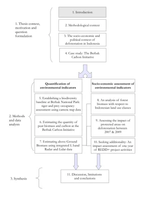
1.2 Outline of the thesis . . . 23
2.1 Semi-variogram . . . 30
3.1 A map of Indonesia showing the indicative forest moratorium map . . . . 62
4.1 Map of the Berbak Carbon Initiative . . . 69
4.2 The forest classes of the BCI, showing villages and canals . . . 72
4.3 Fire hotspots at the BCI between 2001 and 2012 as recorded by MODIS. 73 4.4 Forest police officer (POLHUT) eating the national park’s wildlife. . . . 79
4.5 The park ranger assists with the transport of fish caught inside the park. Fish stored in white bucket. . . 80
4.6 A false colour Landsat 8 image (composite bands 753) of eastern Jambi from June 2013, showing the BCI project area. A new clearcut has been created just south of the BCI. The BCI is outlined in red . . . 82
5.1 A Sumatran tiger photographed at Berbak National Park. Image sup-plied by ZSL Indonesia. . . 88
5.2 Location of camera grid . . . 90
5.3 Tiger prey species camera history . . . 95
5.4 Tiger camera history . . . 96
6.1 Peatland estimation processing chain . . . 109
6.2 Histogram of the peat core data . . . 115
6.3 Outline of the Berbak project drawn in pink and peat core sample as blue points . . . 116
6.4 Lattice of canals draining the peatland . . . 117
6.5 The ’virtual deforestation’ model, with vegetation height subtracted from the srtm data . . . 118
6.6 From top to bottom: Transects A,B,C,D . . . 119
6.7 Semivariogram for the peat depth data . . . 119
6.8 Model validation for the kriging of the peat depth data . . . 120
6.9 3D model of the peat at Berbak . . . 121
7.1 Excluded flooded forest . . . 132
7.3 Non-linear relationship between Lorey’s height and biomass . . . 134
7.4 Linear relationship between backscatter and Lorey’s height . . . 135
7.5 Deforestation image . . . 136
8.1 Land classes . . . 145
8.2 Data extraction . . . 146
8.3 Mean Biomass per pixel by forest class . . . 148
8.4 Cumulative Distribution Functions of each land use class,including Berbak and the Moratorium . . . 150
8.5 Frequency distributions of biomass. X axis is 2007 biomass Mg ha−1 . . . 151
8.6 Frequency distributions of biomass per pixel in the entire study area, Berbak National Park, Berbak Carbon Initiative and the REDD+ Mora-torium . . . 152
8.7 Protected hutan lindung forest with virtually no forest remaining . . . . 154
9.1 Basic DID illustration . . . 164
9.2 Independent variable creation . . . 174
9.3 PAs (blue, diagonal lines) superimposed on in-tact forest (green) and deforestation that occurred between 2007 and 2009 . . . 176
9.4 Genetic matching results . . . 179
9.5 Deforestation boxplots pre-post matching . . . 180
10.1 Extent of the 2010 radar data . . . 194
10.2 Study area map . . . 198
10.3 Trends pre-match . . . 201
10.4 Genetic matching results . . . 203
10.5 Trends post-matching . . . 204
10.6 Model analysis . . . 207
List of Tables
4.1 The components of the Berbak Carbon Initiative . . . 704.2 Competing incentives to local government for alternative land uses . . . 78
5.1 Summary statistics for the independent variables for camera trapping . . 92
5.2 Candidate models . . . 94
5.3 A list of mammals photographed in Berbak National Park during the two camera trapping grids . . . 96
5.4 Candidate models . . . 97
5.5 Tiger detection candidate sub-models . . . 98
6.1 Results of the Normalisation of the vegetation height model and SRTM data . . . 115
6.4 Results of the regression between peat depth and the surface model made
by kriging the patches of bare earth in the SRTM data. . . 117
6.5 Results of the regression between peat depth and the surface model made by ’virtually deforesting’ the project site. . . 118
7.1 Results of the non-linear regression between Lorey’s height and the above ground biomass in the forest plots. . . 134
7.2 Regression equations for relationship between HV backscatter and Lorey’s height . . . 134
8.1 Forest biomass by land class . . . 148
9.1 Matching results . . . 178
10.1 Descriptive statistics for independent variables . . . 198
10.2 Matching results . . . 202
Declaration
1
I certify that the thesis I have presented for examination for the PhD degree of the 2
London School of Economics and Political Science is solely my own work other than 3
where I have clearly indicated that it is the work of others (in which case the extent 4
of any work carried out jointly by me and any other person is clearly identified in it). 5
The copyright of this thesis rests with the author. Quotation from it is permitted, 6
provided that full acknowledgement is made. This thesis may not be reproduced 7
without my prior written consent. I warrant that this authorisation does not, to 8
the best of my belief, infringe the rights of any third party. As of submission, none 9
of the work in the thesis has been published. I declare that my thesis consists of 10
Acknowledgements
12
This PhD represents four years of work, and would not have been possible without 13
the support of my supervisors, family and innumerable friends and colleagues. Mar-14
cus Rowcliffe, Chris Carbone and Susanna Mourato established the PhD position in 15
the first instance and provided invaluable guidance, encouragement, advice and help 16
throughout. Charles Palmer then stepped into the breech in the penultimate year 17
of the PhD to become my main supervisor at LSE, and I greatly appreciate his con-18
tinual encouragement to improve and develop the work and guide the thesis towards 19
completion. I am very grateful to everyone at the Grantham Research Institute for 20
hosting me during my PhD, and to all my colleagues there who have provided help 21
and advice, and become friends. This was a wonderful place to work. Thank you. 22
Ed Mitchard diligently supervised the remote sensing work and provided detailed 23
responses to emailed questions seemingly only seconds after the email had left my 24
outbox. I am also very grateful for him hosting me for a very productive two weeks 25
in Edinburgh. Thanks to Mandar Trivedi for always providing his cheerful help and 26
advice. Thanks also to Karen Jeffers for her friendship and faultless attention to 27
detail processing data. In Indonesia, my thanks to the entire ZSL Indonesia team in 28
Bogor and in Jambi, especially Laura D’Arcy and Dolly Priatna for helping me get 29
to Indonesia in the first place and then to get to Berbak national park. The field 30
team regularly work in tough conditions, yet still produce results. So I thank Pak 31
Mulya, Citra Novalina and the rest of the field team for their efforts in collecting 32
and collating data used in this thesis. I would like to thank the Government of 33
Indonesia; the Ministry of Forestry; the Indonesian Academy of Sciences and Pak 34
Laode for granting permission to undertake research in Indonesia, and for providing 35
the assorted visas, letters and permits. Thanks too to my friends in The Bog who 36
made it an enjoyable time. The love and support of my all my friends and family 37
throughout has been utterly invaluable: thanks Rosie, Nat, Maria, George and Jack. 38
Thank you Maryam for your endlessly understanding nature and kindness. Thank 39
you Jeremy, not a short man. In particular I am eternally grateful for the unending 40
help and support from my parents who continually encouraged me to pursue my 41
education over the years. Most recently I want to thank my Mother for everything 42
she has done to make this work possible. I am grateful to the members of TNC for 43
their wisdom. Finally, on a technical note, much of the work in this thesis was en-44
Glossary
47
• AGB: Above Ground Biomass
48
• ALOS-PALSAR: Advanced Land Observing Satellite - Phased Array type
L-49
band Synthetic Aperture Radar 50
• AWGLCA: Ad Hoc Working Group on Long Term Cooperative Action
51
• BCI: Berbak Carbon Initiative. This is the case study for the thesis. It is
52
comprised of Berbak national park and adjacent protected and production 53
forests. 54
• COP: Conference of the Parties to the UNFCCC
55
• DEM: Digital Elevation Model: a representation of the height and structures
56
of the surface of the earth 57
• Lidar: Light Detection and Ranging
58
• LULUCF: Land Use, Land Use Change and Forestry
59
• MODIS: The Moderate Resolution Imaging Spectroradiometer
60
• NASA: National Aeronautics and Space Administration
61
• REDD+: Reducing Emissions from Deforestation and Degradation in
develop-62
ing countries, and the sustainable management, conservation and enhancement 63
of forest carbon stocks. 64
• VEM: Vegetation Elevation Model: an approximation of the vegetation across
65
the surface of the earth; e.g. where SRTM data does not fully penetrate the 66
forests canopy. 67
• SRTM: Shuttle Ranging and Topography Mission. NASA mission to map the
68
Earth’s topography. 69
• QANS: Quick Assessment and Nationwide Screening. A programme to model
70
peatland extent and depth across Indonesia. 71
• UNFCCC: United Nations Framework Convention on Climate Change
72
• ZSL: Zoological Society of London
0.1
SI Units
74
SI Units are used throughout the thesis. 75
Pg Peta: 1015
76
Mg Mega: 106
77
Gg Giga: 109
78
0.2
Assorted Indonesian terms used regularly
79
• Hutan lindung: Protected forest class managed by provincial forestry offices.
80
Often used to protected ecosystem services e.g. watershed protection. 81
• Hutan produksi: production forests. Used for exploitation for timber or
con-82
version to other land uses (which is called hutan produksi konversi). Hutan
83
produksi terbatasis limited production forest, where conversion to other land
84
use types is not permitted. 85
• TAHURA; Taman Hutan Raya: Forest Park. Another protected forest
cate-86
gory. 87
• Suaka Margasatwa: Wildlife reserve.
88
• Taman Nasional: National Park.
89
• Uani piro (n.b. this is Javanese language rather than the Lingua Franca of
90
Bahasa Indonesia): This means approximately ’money for looking the other 91
way’, ignoring illegal activity. 92
• Kabupaten: a spatial political division, a ’regency’. Several kabupaten make
93
up one propinsi. 94
• Propinsi: a province. Multiple provinces constitute the Indonesian state.
95
• DINAS Kehutanan Propinsi: provincial forestry service.
Abstract
97
Tropical forests are being cleared rapidly, causing between 12 and 20% of all anthro-98
pogenic CO2 emissions. This process drives climate change and biodiversity loss. A
99
new mechanism called REDD+ is being developed to pay tropical forest countries to 100
reduce deforestation, and thereby to reduce these negative externalities. To be able 101
to do this, maps of forest carbon stocks and change are fundamental. Policy impact 102
analysis is essential too since REDD+ payments are performance-based. Quantify-103
ing biodiversity benefits of REDD+ is important too for carbon credit buyers. This 104
thesis addresses these needs on Sumatra. As of 2007, a 7.2Mha study area holds 503 105
±105 x 106 Mg of forest biomass, with the largest stocks in protected and production
106
forests. Other land classes have much lower biomass, suggesting legally exploitable 107
forests are already depleted. What forest remains is being cleared rapidly. Between 108
2007 and 2009, 229 x 103 ha of forest were cleared, a rate of 1.6% yr−1, and loss
109
of >6% of the 2007 forest biomass, creating emissions of 58 ±12.1 x 10⁶ Mg CO
2e. 110
Yet the deforestation is not uniform. On average protected forests reduce defor-111
estation. However at the extreme, one protected forest area had virtually no forest 112
remaining at all by 2007. By contrast the Berbak Carbon Initiative REDD+ pilot 113
project has significant stocks (34.7 ± 17.3 ±3.5 x 10⁶ Mg forest carbon; 380 x 106
114
Mg peat carbon). It also supports a population of critically endangered Sumatran 115
tigers (occupancy Ψ=0.14; 95% CI= 0.05:0.33). The project developers hope to con-116
serve tigers and carbon simultaneously. However, following the first year of project 117
Chapter 1
119
Introduction
120
1.1
Policy background: Deforestation and
121
degradation, climate change and biodiversity
122
loss
123
Tropical forests provide multiple ecosystem services such as atmospheric regulation, 124
carbon storage, biodiversity provision and fresh water supply. Yet they continue to 125
be cleared and degraded. Deforestation and degradation in developing countries ac-126
counts for a large proportion of anthropogenic CO2 emissions, estimated at between
127
7 and 20% of the total: 20% (Solomon et al., 2007); 15% with range 8-20% (van der 128
Werf et al., 2009) 7-14% (Harris, 2012), ultimately with between 0.9 2Pg C yr−1
129
(Houghton, 2010) and 1.0 Pg C yr−1 (Baccini et al., 2012) being transferred to the
130
atmosphere (Pg is petagrammes; 1015grammes; see SI units section in glossary).
131
Preventing dangerous climate change will therefore be much more difficult if 132
tropical deforestation is not reduced or reversed. This emphasises the importance 133
of improved forest management, which is at the top of the list of global environmen-134
tal concerns for reasons other than climate change. At the time of writing, news 135
headlines globally are dominated by reports of Indonesian forest fires filling the air 136
over Singapore with a pall of thick smog. Walking the island-state’s streets has 137
become hazardous: in June 2013 Singapore’s Pollutants Standards Index rose to 138
370 thereby exceeding the ”hazardous designation” of over 300 (Gaveau, 2013). Air 139
transport has been hampered by reduced visibility leading to unquantified produc-140
tivity losses. Whilst these stories make compelling headlines when rich countries are 141
affected, the underlying processes which ultimately lead to these fires continue each 142
year across the Indonesian archipelago, causing not just dangerous particulate pol-143
lution locally for Indonesians, but also a slew of other negative externalities across 144
scales. Locally, the clearance of forest causes the loss of ecosystem services: Locally, 145
reduced forest cover and fragmentation is associated with micro-climatic changes; 146
son et al., 2013; Koh and Sodhi, 2010). Globally, increased carbon emissions forces 148
anthropogenic climate change. The effects of biodiversity loss are felt internationally 149
too. In hypothetical markets at least, people in rich countries value the existence 150
of forests and other species (Baranzini et al., 2010; Bienabe and Hearne, 2006). 151
The Sumatran tiger Panthera tigiris sumatrae is now classified as Critically
En-152
dangered by the International Union for the Conservation of Nature (IUCN, 2013). 153
Greater commitment at the government level e.g. Ministry of Forestry (2010) and 154
more generally greater exploitation of non-use values (Alexander, 2000) are required 155
to prevent their extinction, such as linking their conservation to carbon payment 156
schemes (Dinerstein et al., 2013). 157
1.1.1
The significance of peat swamps for carbon storage
158
and emissions
159
Tropical peat swamp forests are of crucial importance for REDD+ because they 160
store huge quantities of carbon. Jaenicke et al. (2008) explains how this may be up 161
to one order of magnitude more carbon than tropical forests on mineral soils (up 162
to 10 x 103Mg C ha−1) and therefore one of the richest terrestrial carbon stores
163
(Jaenicke et al., 2008). Furthermore, in-tact peat swamps continually sequester 164
carbon, meaning they are a natural net carbon sinks when undisturbed (Sorensen, 165
1993). Within the context of climate change, carbon storage is important to avoid 166
future emissions, but the fact that peat swamps also sequester carbon means that 167
if they were to be managed wisely, they could actually contribute to removing CO2
168
from the atmosphere. The current potential annual carbon sequestration of tropical 169
peatlands is estimated at 35 x 1012 Mg yr−1. However, the crucial caveat is ’if they
170
are managed wisely’. However,under the pressures of growing, and more affluent 171
populations, these peatlands are being rapidly drained and cleared of forest. Damage 172
to the system undermines its stability, and the loss of the sequestration potential 173
until the peat becomes a net source of emissions (Hooijer et al., 2010, 2012). 174
More than half the world’s tropical peatlands are found in S.E.Asia (Hooijer 175
et al., 2012). An estimated 65% (22 million ha) of S.E. Asia’s peatland is found in 176
Indonesia in coastal and sub-coastal regions on Sumatra, Borneo and West Papua. 177
It covers 13.9% Indonesia’s land area (Page et al., 2007, 2011). In an assessment of 178
the entire archipelago Jaenicke et al. (2008) estimated that Indonesia’s peatlands 179
together store 55 x 106Gg carbon. However, with the pressures of the world’s
fourth-180
largest population of at least 230 million people (World Bank, 2011), and a growing 181
economy based on the mass exploitation of its natural resource base, Indonesia’s 182
remaining peat forests are being extensively cleared for their timber and for land to 183
create new palm oil and pulpwood plantations (Hansen et al., 2009). Hooijer et al. 184
(2010) highlights that as of 2006, approximately half of all Indonesia’s peatland 185
-1
0
.4
0
0
-1
0
.4
0
0
0
.0
0
0
0
.0
0
0
104.000
104.000
114.400
114.400
124.800
124.800
Indonesia
Sumatra
Java
[image:15.595.114.534.53.358.2]Berbak National Park
Kalimantan
Figure 1.1: A map of Indonesia showing the main islands, and highlighting the position of Berbak National Park. This is the site of the Berbak Carbon Initiative, a pilot REDD+ project developed by the Zoological Society of London.
extremely fast pace. Miettinen et al. (2011) describes how even with a part of the 187
world renowned for its rapid land cover change, the changes in areas where peat is 188
found are very high. By 2010, the eastern lowlands of Sumatra had lost half of the 189
peatland forest cover that they had in 2000 (Miettinen et al., 2011), a loss rate of 190
5% yr−1 over the ten year period.
191
Whilst peatland conversion produces short term financial benefits for land own-192
ers, it creates negative externalities. Specifically, the conversion process involves 193
the construction of canals to drain the waterlogged peat and to provide land ac-194
cess. This causes consolidation and compaction of the peat. As the drained peat 195
dries, the constituent part-decayed organic matter oxidises due to microbial activity. 196
Oxidation of the carbon releases CO2 to the atmosphere and causes subsidence as
197
the organic material decomposes. In coastal swamps subsidence may even lead to 198
sea water intrusion. Evidence suggests that these changes occur even if the water 199
table is maintained at a high level by land managers. This means that subsidence 200
and greenhouse gas (GHG) emissions from peat is an inevitable consequence of 201
converting tropical peat swamp forests to other land uses even with management 202
programme in place (Hooijer et al., 2012). Drying caused by drainage also increases 203
peat’s flammability. So when fires are used by land owners to clear the above ground 204
vegetation, the peat also ignites. The peat may then burn for extended periods, and 205
the following dry season. This further accelerates carbon emissions. 207
The huge size of these peat carbon stocks, and the pace of their destruction 208
paints a dire picture for the global climate. Even if a land manager attempts to 209
maintain high water levels in peatlands that are being used for plantations, the 210
evidence shows that it will still collapse and cause emissions (Hooijer et al., 2012). 211
There is therefore a need to manage peat to mitigate damage from these processes. 212
In the context of REDD+ and climate change this is even more important. 213
At its most basic, peat management requires information on the depth and 214
distribution of peat. Yet whilst peat distribution maps do currently exist globally 215
(Joosten, 2009) and for Indonesia (Jaenicke et al., 2008) the accuracy of these has 216
been contested and therefore need to be critically examined (Stahlhut and Rieley, 217
2007). Peat swamps are extremely hard to access, so estimations of peat extent and 218
volume are made with limited field data sets. In addition to this lack of detailed 219
information on peat thickness, there is variation in definitions of peat, leading to 220
greater uncertainty in the quantity of peat in a given location (Page et al., 2007). 221
1.1.2
The development of REDD+ as a climate change
222
mitigation mechanism
223
Forests have historically been excluded as a means to mitigate climate change for 224
several reasons. Rich countries have questioned whether reductions in deforestation 225
could be secured over the long term (permanence); and whether the interventions 226
and payments made to forested countries would lead to reductions in deforestation 227
over and above the changes that might have been expected to occur anyway (ad-228
ditionality) (Baker et al., 2010a; Santilli et al., 2005). Poor countries with large 229
forests have expressed concern that new finance for forest management would lead 230
to a loss of sovereignty over their land, resources and development strategies. A 231
further concern raised was that paying poorer unindustrialised countries to reduce 232
deforestation would simply become a huge multi-lateral carbon offsetting project 233
that would crowd out efforts to reduce carbon emissions in rich industrialised coun-234
tries instead of supplementing them (supplementarity). Finally, one of the main 235
concerns of trying to implement spatially explicit programmes to reduce deforesta-236
tion is that in a dynamic international market, reductions in deforestation in one 237
area would simply be met with equivalent increases in deforestation in another area 238
(leakage). 239
Consequently only re-forestation and afforestation were incorporated into the 240
Clean Development Mechanism of the Kyoto Protocol as valid activities to generate 241
carbon credits from forestry under the umbrella category of Land Use, Land Use 242
Change and Forestry (LULUCF). The reduction of deforestation and degradation 243
or the conservation of standing forests was excluded. However in 2007 the idea of 244
mitigation strategy was established. This followed the 13th Conference of the Par-246
ties to the United Nations Framework Convention on Climate Change (UNFCCC) 247
in Bali (COP13) and the development of the Bali Action Plan. Here, a group of 248
forested tropical countries calling themselves the Coalition for Rainforest Nations 249
(CfRN) lobbied for the inclusion of RED as a way for them to meaningfully par-250
ticipate in climate change mitigation and to access funds from the international 251
community. This mirrored continued academic proposals for forests’ inclusion un-252
der the UNFCCC and a post-Kyoto Protocol climate change agreement (Santilli 253
et al., 2005). RED is a climate change mitigation strategy to address the failure 254
of markets to price the negative externality of carbon emissions from deforesta-255
tion, involving international transfers from rich country governments and private 256
sector actors, to forest-rich but financial resource-poor countries. The definition 257
of RED subsequently expanded to include degradation, that is Reduced Emissions 258
from Deforestation and Degradation (REDD). Then, at the 15th conference to the 259
parties of the United Nations Framework Convention on Climate Change (COP15, 260
UNFCCC) the Ad Hoc Working Group on Long Term Cooperative Action (AWG-261
LCA) expanded the definition to include the Sustainable Management of Forests and 262
the Conservation and the Enhancement of Forest Stocks, which gives the acronym 263
its ’+’. In summary, REDD+ includes (a) Reducing emissions from deforestation 264
(RED); b) Reducing emissions from forest degradation (REDD); c) Conservation 265
of forest carbon stocks (REDD+); d) Sustainable management of forests(REDD+); 266
e)Enhancement of forest carbon stocks (REDD+) (AWG-LCA, 2009). 267
1.1.3
REDD+ activity
268
Following the development of the Bali action plan there has been extensive devel-269
opment of REDD+ action, at both national and international levels. This includes 270
passing of laws and developments of policies in tropical forest counties to facilitate 271
the development of REDD+, including in national plans and laws in Indonesia, 272
Ghana, Brazil and Vietnam, (Townshend et al., 2013). These laws and policies 273
have been developed in order to enable the development of both small scale project 274
development and national schemes which can access funds available from the inter-275
national community. Of the multilateral projects the United Nations Programme on 276
Reducing Emissions from Deforestation and Degradation (UN REDD Programme) 277
scheme has been important in bringing together forested countries and support-278
ing national REDD+ schemes, drawing on the experience of work of the Food and 279
Agriculture Organisation and the UN Environment and Development Programmes 280
(UNEP;UNDP). Currently the UN-REDD programme has 47 partner countries with 281
16 receiving direct support to their National Programmes. In particular it has been 282
instrumental in orchestrating the development of the National Forest Monitoring, 283
formed consent for people upon whom REDD will impact, such as subsistence users 285
of forest products (’local people’); and the development of REDD+ Safeguards and 286
Social and Environmental Standards (REDDStandards.org, 2012). 287
In addition, the World Bank has its own mechanism, called the World Bank 288
Forest Carbon Partnership Facility (FCPF) which has selected six partner countries 289
in Africa (Democratic Republic of Congo, Gabon, Ghana, Kenya, Liberia, Mada-290
gascar); five in Latin America (Bolivia, Costa Rica, Guyana, Mexico, Panama); and 291
three in Asia (Nepal, Lao PDR, and Vietnam). The goal of the partnership is to 292
build the capacity of each of the partner countries to implement activities to reduce 293
deforestation and forest degradation; monitor, report and verify these activities; and 294
participate in nascent carbon markets. 295
1.1.3.1 REDD+ and biodiversity conservation
296
The possibility of carbon-based financing for forest conservation has lead to a great 297
deal of excitement in the academic conservation biology literature at least, with 298
carbon credits being perceived as a new way to fund conservation activities, partic-299
ularly in places where there is overlap between high biodiversity and carbon values 300
e.g. Venter et al. (2009a,b) though there has been concern that the focus on carbon 301
values will lead to the bias in the conservation of peat swamp forests which are 302
less biologically diverse and have lower abundance of threatened (and charismatic) 303
mammal species than forests on mineral soils (Paoli et al., 2010). 304
One such charismatic species is the Sumatran tiger. Indeed the funding and 305
opportunity for this PhD research derived from the establishment of the Berbak 306
Carbon Initiative in Jambi province, the case study for the thesis. The initiative 307
is a pilot REDD+ project established by the Zoological Society of London to ex-308
plore whether REDD+ could contribute to tiger conservation. In Jambi, some of 309
Indonesia’s and indeed the world’s last tigers remain in increasingly isolated blocks 310
of forests. These forests are the target of exploitation by plantation and logging 311
companies on the one hand, and the focus of carbon mitigation and biodiversity 312
conservation schemes on the other. Some of these forests have been included in a 313
forest logging moratorium imposed by the Indonesian government as a part of a bi-314
lateral deal with the Government of Norway under the banner of Reduced Emissions 315
from Deforestation and Degradation (REDD+) (Murdiyarso et al., 2011a). 316
1.2
Problem statement
317
There are significant data and methodological requirements for the implementation 318
of REDD+. At the most fundamental level it is required to know the location and 319
amount of biomass across the landscape, in both the above (vegetation) and below-320
of REDD+ can simultaneously address climate change and biodiversity loss, it is also 322
required to estimate the biodiversity attributes of forests under REDD+ schemes. 323
Whilst this information is necessary, it is not sufficient. REDD+ implementation 324
requires an understanding of the socio-economic, political and legal conditions which 325
regulate land use. This requires not only qualitative understanding, but also the 326
quantification both of the drivers of deforestation, and the impact of past policies 327
designed to reduce deforestation such as national parks. Finally, when new policies 328
are created, there is a need for causal inference in order to be able understand what 329
works in forest conservation, and where it works. 330
1.3
Aims of the data chapters
331
Three natural science chapters form the first half of the data-driven component of 332
the thesis. The aims of these were to estimate the occupancy of tigers and their 333
potential prey species (chapter 5); estimate biomass and carbon stocks below-ground 334
in the peat soils (chapter 6) and above-ground in the forest (chapter 7. Next, three 335
social science chapters complete the data-driven section of the thesis. The aims of 336
these were to analyse the patterns of biomass distribution estimated for 2007 with 337
reference to institutional conditions, specifically the official land use designations 338
(chapter 8). Then, by exploiting the estimation of the change in forest cover over 339
time, the next aim was to assess the impact of protected areas on forest loss (chapter 340
9. For the final data chapter of the thesis, the aim was to assess the impact of one 341
year of REDD+ project activities on deforestation rates at Berbak national park. 342
The specific objectives of each chapter are discussed in the following section. 343
1.4
Objectives of the data chapters
344
1.4.1
Establishing a biodiversity baseline: tiger and prey
345
occupancy analysis using camera trap data
346
Since the Berbak Carbon Initiative (BCI) was initiated in order to conserve tigers, a 347
crucial piece of research is to quantify aspects of the tiger population at the site. The 348
objective of this chapter was therefore to estimate tiger occupancy at Berbak, using 349
camera trapping data. A second objective was to use the same camera-trapping 350
estimate the occupancy of the tiger’s prey at the site. 351
1.4.2
Estimating the quantity of peat biomass and carbon
352
at the Berbak Carbon Initiative
353
The BCI project site is important for Indonesian REDD+ because it is largely 354
(Page et al., 2002). A nationwide-wide effort was recently conducted to estimate 356
the quantity of peat, but for an unknown reason the models developed could not 357
deal with the data gathered at Berbak, rendering the area a ’blank spot’ on the peat 358
map. This presents a significant problem for the project, and an interesting applied 359
research question. The aim was therefore to use geo-spatial methods to quantify the 360
volume of below-ground biomass at the site, and from this to estimate the quantity 361
of carbon stored. 362
1.4.3
Estimating above ground biomass using integrated
363
L-band Radar and Lidar data
364
The objective of this chapter was to provide the most accurate estimation possible 365
of the biomass in the forests of the study area surrounding the Berbak project site. 366
A secondary objective was to quantify the changes of the biomass over time. 367
1.4.4
An analysis of forest biomass with respect to
368
Indonesian land use classes
369
The purpose of this chapter was to take the findings of the forest biomass estimation, 370
and to explore these in the context of Indonesia’s official land use classes. This was 371
done in order to understand which land use classes still held the largest amounts 372
of forest biomass and as such which would potentially contribute the most to the 373
conservation of forest carbon stocks, and which had already lost their forest. It asks: 374
what are the relationships between the levels biomass and the land use classes in the 375
study area? Are there significant differences between the distributions of biomass 376
in each forest class? Which forest class had the lowest mean forest biomass per 377
hectare, and which the highest? 378
1.4.5
Assessment of the impact of protected areas on
379
deforestation between 2007 and 9
380
The purpose of this chapter is to understand to what degree the protected areas 381
have reduced deforestation during the study period. Specifically, did the protected 382
areas provide additional forest protection when contrasted with the other land use 383
classes in the study area? 384
1.4.6
Seeking additionality: an impact assessment of the
385
impact of a year of REDD+ intervention
386
The objective of this chapter was to quantify the impact of one year of the imple-387
did the risks of deforestation inside the protected area change after the project be-389
gan conservation activities there? This was in response to the challenge set out in 390
the literature for the impact of projects to be rigorously assessed. Additionally it 391
sought to test a hypothesis that the mere presence of researchers in the field was 392
sufficient to reduce the risks of deforestation. 393
1.5
Novelty and research contributions of the
394
thesis
395
The research provides novel contributions to the literature on monitoring of trop-396
ical forests and the impact of policies to conserve them. At the most basic level, 397
the research provides novel baseline informationabout a data poor region which
398
has enormous potential to contribute to climate change mitigation and biodiver-399
sity conservation. It then provides new methodological contributions through
400
the development of forest monitoring technologies, and new policy contributions
401
through the assessment of forest conservation activities. These are discussed in turn: 402
1.5.0.1 Baseline data
403
1. To the knowledge of the author, this is the first study to have quantified peat 404
volume and carbon stored in the Berbak ecosystem. A recent collaboration 405
between multiple NGOs led by an international environmental consultancy 406
tried to develop a nation-wide model of peatland distribution, but the model 407
did not fit the Berbak region. As such the estimate provided here is the sole 408
estimation to date of the huge quantities of carbon stored. 409
2. This is the first study to provide systematic baseline information on the mam-410
mal fauna at Berbak; and to quantify this biodiversity in a robust ecological 411
monitoring framework that accounts for detectability and the environmental 412
co-variates of site occupancy. The development of population statistics will 413
allow future analysis to assess not only the state of tiger prey at a given point, 414
but also the change in the status of the prey since 2009. 415
3. The baseline biomass estimation for 2007 across the 7.2Mha study area pro-416
vides a rich data set to explore the relationship between land use classes and 417
forest biomass and carbon stocks. 418
1.5.1
Methodological contributions
419
1. The main methodological contributions were made in the work to calculate 420
the forest biomass and the change in that biomass over time. The value of 421
perennial problem of cloud and smoke obscuring forest could be overcome 423
using a combination of active radar and lidar sensing. It further showed how 424
by using relative normalisation and threshold-limited differencing of annually 425
gathered radar data, it was possible to measure change against the baseline of 426
forest biomass. This allowed estimates not only of the total area cleared during 427
the study period, but also of the total emissions arising from the process. 428
1.5.2
Policy contributions
429
1. The assessment of the impact of protected areas during the study period pro-430
vides important contribution to the understanding of land use change in a 431
region undergoing some of the fastest change in the world. Only one other 432
analysis has addressed this question before on Sumatra but using a much older 433
data set. Nonetheless, this more recent analysis supports the conclusions of 434
the earlier work, and suggests that even matching pixels for the predictors of 435
deforestation, that the protected areas are contributing to forest conservation. 436
This has important implications for the way in which forest is managed in 437
Indonesia and particularly for how REDD+ is implemented: empirical assess-438
ments of what actually works in conservation interventions has increasingly 439
been called for in the literature. 440
2. It was increasing demand to see quantitative assessment of the policy inter-441
ventions that also motivated the final empirical chapter, which provides the 442
first quantification of the performance of one year of a REDD+ pilot project.
443
This provides the most significant policy contribution. 444
1.5.3
Interdisciplinarity
445
This thesis represents the first institutional collaboration between the Institute of 446
Zoology at the Zoological Society of London, and the London School of Economics 447
and Political Science in order to develop a PhD. As such it incorporates a range of 448
ideas, research methodologies and concepts. 449
1.6
Overview and structure of the thesis
450
The thesis is broken down into 1. a background section, 2. a data-driven section 451
and 3. a discussion. The data-driven section is in turn divided into three natural 452
science and three social science chapters. An outline of the thesis is provided at the 453
beginning of each chapter, highlighting the reader’s position in the text. 454
The thesis begins with a review of the methodological context that reviews the 455
key relevant literature (chapter 2). The next chapter then reviews the literature of 456
8. An analysis of forest biomass with respect to Indonesian land use classes
10. Seeking additionality: An impact assessment of one year
of REDD+ project activities 9. Assessing the impact of
protected areas on deforestation between
2007 & 2009 2. Methodological context
1. Introduction
3. The socio-economic and political context of deforestation in Indonesia
1. Thesis context, motivation and question formulation
5. Establishing a biodiversity baseline at Berbak National Park:
tiger and prey occupancy assessment using camera trap data
6. Estimating the quantity of peat biomass and carbon at the
Berbak Carbon Initiative
4. Case study: The Berbak Carbon Initiative
2. Methods and data analysis
11. Discussion, limitations and conclusions
Quantification of
environmental indicators Socio-eonomic assessment ofenvironmental indicators
7. Estimating above Ground Biomass using integrated L band
Radar and Lidar data
[image:23.595.177.472.62.468.2]3. Synthesis
Figure 1.2: An outline of the PhD thesis, with the reader’s current position high-lighted.
forest distribution and deforestation (chapter 3). In particular it focuses on land use 458
policy and governance, and the trend towards the centralisation and monopolisation 459
of resources. This begins with the Dutch colonial period, through to independence 460
and more recently reformasi and multi-party democracy. Following this, chapter
461
(4) draws on this background but focuses on Jambi province in Sumatra, where the 462
general patterns described across Indonesia are grounded in case study of the Berbak 463
Carbon Initiative (BCI). This is a REDD+ pilot project centred on Berbak National 464
Park and established by the Zoological Society of London to support the conserva-465
tion of the Critically Endangered Sumatran Tiger. This concludes the background 466
information section. 467
The following chapters are empirical, and based on the analysis of a series of 468
different data sets. First (chapter 5) is the quantification of attributes of biodiver-469
sity at the project site using a six month camera trapping survey analysed in an 470
for both tigers and their prey at the study site, which is an estimate of the proba-472
bility of occurrence of a species, accounting for detection probability. Next, chapter 473
6 quantifies the below ground biomass stocks within the boundaries of the Berbak 474
project site using spatial statistics (kriging). This provides a total volume estima-475
tion for the amount of peat biomass and carbon at the site. The following chapter 476
7 quantifies a) a baseline of the forest biomass in a 7.2 M ha swathe of Jambi and 477
South Sumatra provinces, and b) the changes in this biomass and the associated 478
emissions between 2007 and 2009. Next, chapter 8 explores the distribution of the 479
forest biomass in 2007 with respect to the government’s land use classes, and ex-480
plores whether there are any differences between the different designations in order 481
to provide a descriptive analysis of the study area. 482
The next section of the thesis examines the deforestation data. First, the entire 483
7.2Mha study area is examined in chapter 9 in order to test whether protected area 484
status had any effect on the risk of deforestation between 2007 and 2009. Once again, 485
this study then focusses down onto the case study area surrounding Berbak National 486
Park (chapter 10). Deforestation in Berbak is compared with the deforestation in 487
control sites before and after the implementation of one year of REDD+ pilot project 488
activities. The final chapter summarises the key findings of the thesis and discusses 489
Chapter 2
491
Methodological context
492
8. An analysis of forest biomass with respect to Indonesian land use classes
10. Seeking additionality: An impact assessment of one year
of REDD+ project activities 9. Assessing the impact of
protected areas on deforestation between
2007 & 2009 2. Methodological context
1. Introduction
3. The socio-economic and political context of deforestation in Indonesia
1. Thesis context, motivation and question formulation
5. Establishing a biodiversity baseline at Berbak National Park:
tiger and prey occupancy assessment using camera trap data
6. Estimating the quantity of peat biomass and carbon at the
Berbak Carbon Initiative
4. Case study: The Berbak Carbon Initiative
2. Methods and data analysis
11. Discussion, limitations and conclusions
Quantification of
environmental indicators Socio-eonomic assessment ofenvironmental indicators
7. Estimating above Ground Biomass using integrated L band
Radar and Lidar data
This thesis is multidisciplinary, drawing on both the natural and social sciences 493
in order to make a contribution to understanding changing patterns of forest cover 494
in Indonesia: why deforestation is occurring; how to measure deforestation; estab-495
lishing indices of forest biodiversity; and assessing the impact of policies designed 496
to reduce deforestation. As such, a review of the literature is challenging in that it 497
must span several disciplines, and broach multiple topics. Because of this the re-498
view is broken down as follows. First there is a review of the state of the art in the 499
quantification of environmental indicators. These are the quantification of peat car-500
bon stocks; the quantification of forest biomass and carbon stocks and change over 501
time; and options for measuring biodiversity. Second, there is a review of impact 502
assessment evaluation to measure the performance of policy interventions. 503
2.0.1
Quantification of environmental indicators
504
The environmental indicators of concern to this thesis are first, the biomass and 505
hence carbon stored in a) peat and b) in forests; and second, the biodiversity of 506
those forests. These are now addressed in order. 507
2.0.1.1 Peat volume estimation
508
Peat soils form in shallow basins on the landscape over thousands of years when 509
the production of organic matter exceeds the decomposition rate in waterlogged 510
anaerobic conditions (Stahlhut and Rieley, 2007). The soil accumulates faster at 511
points furthest from rivers in what is termed an ’accumulation zone’. Near major 512
rivers, and near the shallow margins of the depression which it forms, the accumu-513
lation rate decreases and the peat becomes shallower. This leads to the formation 514
of the classic peat dome shape, which forms the core of the physical geography 515
theory (Moore and Bellamy, 1947). This theory underpins the analysis used by 516
contemporary researchers to estimation peat dome volume. 517
S.Page in particular has been influential in highlighting the importance of peat 518
for ecosystem service provision and its potential to adversely affect the climate when 519
damaged. Probably the single most important research finding in this regard was 520
the calculation that between 2.4 and 6.8 M ha peatland burned in Indonesia during 521
the el nino ’fire seasons’ of 1996 and 1997; and that as a consequence which between 522
0.81 and 2.57 x 10⁶ Gg C were released to the atmosphere(Page et al., 2002). This
523
finding was more remarkable though when put into context: the authors claim that 524
theseemissions from just two years of fires in Indonesian peatlands are
525
equivalent of 18-57 years of successful Kyoto climate change protocol
526
implementation. However this research came on the back of a historical dearth of 527
work on peatlands. The authors of an albeit grey literature review for an EU project 528
called Carbopeat (Page et al., 2007) lament that in the two decades after 1985 when 529
not greatly progressed. Page et al. (2007) explain how fundamental concepts like 531
precisely what constitutes ’peat’ and ’tropical peat’ are still being contested, with 532
the main issues of concern being the proportion of organic matter, and the thickness 533
of the peat itself. If today there is still a lack of consensus even over what constitutes 534
peat, then it is perhaps less surprising that research did not progress during those 535
twenty years after 1985. 536
Page et al. (2007) highlight the problems of determining the extent of peat-537
land in Indonesia. This country has the single largest store of peat carbon in the 538
tropics (Page et al., 2011). Sari et al. (2007) highlight how the destruction of peat-539
land ecosystems has brought Indonesia the dubious distinction of being the third 540
largest emitter of CO2 and other greenhouses gases (GHGs) after the mass energy
541
consumers USA and China. However these emissions are not constant; they tend 542
to occur in quite dramatic events. Gaveau (2013) explains how the fires of 2013 543
caused enormous forest losses in peatland areas, recording 140,000 ha burned down 544
in a 3.5M ha study area in the month of June alone. In 2008 Indonesia was by 545
far the largest emitter of CO2 from degrading peat of any country, releasing some
546
500 x 106 Mg CO2 from the process. This is over three times more than the next
547
largest source of emissions, Russia, at 139 x 106 Mg CO2 (Joosten, 2009). However
548
at least prior to 2007 estimates of the extent of the peatland varied significantly, 549
from a minimum of 160,000km2 to a maximum of 270,000km2. Evidently there are
550
significant problems in being able to measure the distribution of, and the quantity 551
of carbon in, peatlands. In particular, their extent is huge, and they are found in 552
remote locations, which means it is difficult to get into the field and take direct 553
measures of thickness using drilling equipment (Page et al., 2011). A large prob-554
lem in trying to resolve these differences in estimates of peatland extent is the fact 555
that during the same period that the estimates were being made, huge land cover 556
changes occurred in Indonesia (Miettinen et al., 2011). This is important since when 557
the forests covering peat are cleared, and the land drained, large amounts of the 558
peat is lost through oxidation of the organic material. So these systems are rapidly 559
changing under anthropogenic pressure even as researchers attempt to define and 560
measure them. 561
A further variable is that both the carbon and bulk density of peat varies across 562
different peat ecosystems (Page et al., 2007). So even when the extent, depth and 563
hence peat volume can be estimated, the final carbon stock ultimately estimated 564
depends on bulk density and carbon content. These uncertainties in each of these 565
values contribute to the propagation of errors that together lead to great uncertainty 566
in the estimations of peat volumes and in turn emissions (Shimada et al., 1999). 567
The most widely-cited estimate is that emissions from tropical peat leads to 568
approximately 3% of all emissions from anthropogenic activity (van der Werf et al., 569
2009). The combination of the huge emissions but with large uncertainties means 570
and estimate storage and emissions. This is all the more pressing in the context 572
of REDD+, as policy makers seek to meet commitments to reduce emissions (e.g. 573
Indonesia has committed to reduce emissions by 26% by 2020, see chapter 3 for 574
details), there is a need to identify the most effective and efficient means to do this. 575
A recent approach has been to use three dimensional modelling to estimate peat 576
volumes. This was driven by the PhD research of Jaenicke et al. (2008), subsequently 577
published as Jaenicke et al. (2010). The essence of this technique is to focus on a 578
specific peatland area, and integrate various pieces of data in order to estimate 579
a) the surface and b) the base of the peat deposit. In theory the peat should be 580
shallower at its margins, and then get deeper further towards the centre of the zone 581
of accumulation (Moore and Bellamy, 1947). This depth should be reflected both 582
in the depth of the deposit (deeper areas forming in the centre of a river basin), 583
but also in terms of the height of the peat. Whereas the depth of the dome has 584
to be measured by going into the field and drilling into the ground - a laborious 585
process - the height of the land can be measured using remote sensing data. If the 586
relationship suggested from theory between the height of the peat dome and the 587
sampled depth of the deposit is sufficiently strong, then the depth can be modelled 588
across the entire deposit without need for further depth samples. Jaenicke et al. 589
(2008, 2010) successfully exploited this relationship to create a 3D model for several 590
Indonesian peat domes and estimate a total peat carbon stock of 55Gt for all of 591
Indonesia. 592
Yet there are some problems with this approach. One is arbitrariness when 593
identifying peatland margins from space: it is surprising that the state of the art in 594
estimating this huge stock of terrestrial carbon ultimately comes down to drawing 595
a line by hand around a satellite photograph of the study site. Yet the problems of 596
working in these remote environments are huge. A further problem is that the re-597
mote sensing technology (C-band radar from the Shuttle Ranging and Topography 598
Missions; SRTM) used to estimate the terrain (which is called a Digital Elevation 599
Model; DEM) does not fully penetrate the forest canopy. This is because the radar 600
interacts with the tree limbs and trunks. Hence the SRTM-derived DEM is accu-601
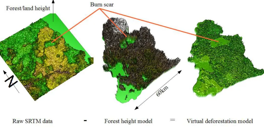
rate on bare land but overestimates height in areas with in-tact forest. Jaenicke 602
et al. (2010) resolved this problem by using a different remote sensing technology (a 603
laser pulsing system called Light Detection and Ranging; Lidar) to estimate forest 604
height across the study sites. These forest height estimates can then be subtracted 605
from the DEM, to create a ’virtual deforestation’ model. However, Lidar data is 606
very expensive to gather and process, requiring commissioning an aeroplane with 607
the specialised equipment mounted to fly over the study area. One of Jaenicke’s 608
co-authors runs a remote sensing consultancy and had access to such a data set. 609
However, most REDD+ project developers, NGOs and government bodies man-610
aging these resources would likely struggle fund this expensive data collection and 611
processing. This sets a research challenge: are there ways of developing virtual
deforestation digital elevation models for peat modelling without
need-613
ing to commission Lidar overflights? This was the first research motivation for 614
chapter 6. 615
Even where this problem can be resolved, the extent of tropical peatlands means 616
that there is an urgency to develop methods to develop peatland models on a land-617
scape scale without having to take a case-by-case approach. One means to do this is 618
to model the peat depth against the geomorphological features which are theorised 619
to determine peatland depth, such as distance from rivers. This approach was set 620
out on a local scale by Shimada et al. (1999). To take such an approach on a nation-621
wide basis would however require a huge amount of data for the entire area for which 622
modelling were to be attempted. This, along with the accelerating destruction of 623
Indonesia’s peatlands, but the promise of at least a partial solution via REDD+, 624
was behind a recent large collaboration of NGOs in Indonesia to try to and develop 625
the best model possible for peatland development. This effort was called Quick 626
Assessment and Nationwide Screening for REDD+ (QANS). Data from sites across 627
the archipelago was gathered together for the first time, providing a data set that 628
would be extremely expensive for any one organisation to gather. As of the time 629
of writing, the results of this assessment are not officially available. However, the 630
headline results are that the project has been successful in modelling peat distribu-631
tion and depth across the archipelago but crucially not for the Berbak peninsular. 632
This is the location of ZSL’s REDD+ pilot project called the Berbak Carbon Ini-633
tiative, which is the case study for this thesis. The lack of success with the QANS 634
model at the Berbak site therefore provided an interesting applied research problem: 635
what other methods could be used to estimate peat volume at the site to
636
help with the REDD+ project. This was the second motivation for undertaking 637
research in this area. 638
2.0.2
Spatial statistics
639
The below ground biomass chapter draws heavily on spatial statistics, and partic-640
ularly on kriging (it is important to note that these statistical techniques are not 641
unique to the analysis of peat). The fundamental assumption behind kriging is 642
that is that things which are closer together are more similar than things which 643
are further apart, that is they are spatial auto-correlated. In some cases this can 644
prove a problem. For instance in chapters 9 and 10, spatial correlation in regression 645
model error terms violates assumptions about error distribution, and so needs to be 646
controlled for. However, spatial correlation can also be useful: where a parameter 647
is sampled across a landscape (e.g. peat depth), the degree of spatial correlation 648
can be used to make estimates of that parameter between sampled sites and at un-649
sampled sites. This idea underpins kriging, which derives from regionalised variable 650
models estimate the relationship between values based both in the distance and 652
direction between sampled points. 653
The first stage in kriging is to construct a semivariogram. This provides infor-654
mation on the spatial auto-correlation of the data, which is how much the difference 655
in the data varies with distance. It is measured in the terms of half the distance 656
squared, hence ’semi-variogram’. Kriging takes spatial autocorrelation information 657
from the sampled sites and uses this to create the weights used to created predicted 658
values at unsampled sites as a function of distance and direction from sampled sites. 659
In the production of the semi-variogram, pairs of sampled sites are binned together 660
to reduce the number of combinations of different data points measuring variation. 661
A regression model is then estimated for the semi-variance and distance. This is 662
best understood with reference to figure 2.1. 663
Figure 2.1: A semivariogram showing the range,sill and nugget. The data taken from the peat depth kriging exercise.
The larger the first derivative of the semi-variogram nearer the origin, the larger 664
the influence the nearest data point will have on the value of the prediction of a 665
value for the unknown point. Other key properties of the semi-variogram which 666
affect the ultimate outcome of the kriging exercise are the range, the nugget and 667
the sill. The range is the point in the variogram where the fitted model line flattens 668
out i.e. where the first derivative approaches zero. Any samples separated by a 669
distance greater than the range are not spatially autocorrelated. The sill is the 670
value on the y axis which the variogram reaches at the range (see figure 2.1). In 671
theory points which are separated by 0 units distance have 0 difference (because 672
they are at the same location) however in reality the difference is greater than 0 673
due to measurement errors either in the sampling device, in the methods (e.g. peat 674
core sampling may involve hitting still-hard trees in the mire and provide false 675
the units of measurement in the production of the semi-variogram. For instance 677
one may consider peat depth at 1000m intervals across the landscape, and whilst 678
the mean difference indeed changes as a linear function of distance from rivers, 679
the first data bin of 0-1000m might itself contain a large degree of variance. This 680
could be because, for instance, of the nature of the bedrock on which the peat 681
forms; anthropogenic disturbance of the peat; and finally simply because there is 682
more unexplained variation in reality than idealised models of the formation of 683
the ombrogenous peat dome would suggest. The difference (as measured on the 684
Y axis) found at the variogram’s nominal distance of zero is called the nugget. A 685
final issue regards trends in the data. Ordinary kriging assumes that the constant 686
mean of the data is unknown, or, that there is no trend in the data. Where there 687
are theoretical geophysical reasons for a trend, trends can be estimated (through a 688
polynomial function in universal kriging) and subtracted from the data, leaving the 689
deterministic element to be calculated from the random errors. 690
2.0.2.1 Forest biomass quantification
691
Emissions from tropical peat are extremely important, but carbon stores in forests 692
are in aggregate even more important to the global climate, hence the development 693
of REDD+. Measuring above ground biomass (AGB), the carbon within it, and 694
changes over time is a central challenge for REDD+ implementation. Remote sens-695
ing using satellite data is absolutely fundamental to be able to do this. Satellite data 696
allows the observation of huge areas of land and the development of relationships 697
with other data sets, such as data from field measurements, like direct measurement 698
of trees (Woodhouse, 2013; Mitchard et al., 2009b). This allows the modelling and 699
estimation of forest attributes across the landscape in a way which would not be 700
possible using field data alone. For the assessment of AGB and change for REDD+, 701
researchers would ideally have high resolution maps made for each year, allowing 702
assessments of the impact of policies to reduce deforestation and forest degradation. 703
Yet there are major challenges to doing this since no satellite sensor directly mea-704
sures biomass (Woodhouse et al., 2012). Further, the relationships between remote 705
sensing data and biomass tend to break down at medium to high biomass levels. 706
This means there is a loss of sensitivity for high biomass forest (Mitchard et al., 707
2009a). However, direct calibration from optical imagery has been performed by 708
Baccini et al. (2012). Detecting biomass change is a more sophisticated challenge 709
still, since this requires repeat estimates across time with well-understood uncer-710
tainties and error propagation. 711
Mitchard et al. (2012) characterized the options available for AGB mapping 712
as (a) the classification of forest into landcover types, which are then attributed a 713
mean AGB value based upon field or remote sensing measurements; or (b) the direct 714
There are different standards for monitoring established under the UNFCCC for 716
reporting carbon emissions reduction activities, which have varying levels of rigour. 717
These standards are called Tiers and numbered 1 to 3, where 1 is the least rigorous 718
and 3 the most. Tier 1 involves the use of default parameter values such as global 719
or country-level land cover maps. Tier 2 requires country-level data at a higher 720
resolution, whilst tier 3 involves the use of high resolution country or region-specific 721
data and models. Approach (a) largely maps onto the less rigorous Tier 1 and Tier 722
2 approaches, whilst Tier 3, involving local modelling, probably requires approach 723
(b) (Arino et al., 2009). In Indonesia, approach a) has been followed most often 724
in efforts to map deforestation and degradation. Most of the current research in 725
this area uses optical imagery to do this, which involves the detection of visible 726
wavelengths of the sun’s light reflected from the surface of vegetation. Since it relies 727
on reflected light, it is referred to as passive sensing. 728
The most commonly-used sensors to do this have been on NASA satellites, 729
namely LANDSAT and MODIS (Moderate Resolution Imaging Spectroradiome-730
ter). For instance, in an assessment of the projected impacts of REDD+ in north-731
ern Sumatra, Gaveau et al. (2009c) used composite LANDSAT images to estimate 732
forest loss. More recent for forest monitoring on Sumatra efforts integrate MODIS 733
data in addition to LANDSAT. Broich et al. (2011a) used this combination to map 734
forest change across both Sumatra and Kalimantan. However the latter work high-735
lighted one of the central challenges of identifying forest type from remote sensing 736
imagery: in areas with persistent cloud cover like the humid tropics, it is rare for 737
the satellite sensors to record completely cloud free images. This means that im-738
ages from several years often have to be stitched together in composites in order 739
to provide the final images for analysis. This is a frustrating challenge in itself. 740
However, a more substantive problem is that multi-year composites mask deforesta-741
tion and regrowth occurring during the time period over which the composite was 742
created (Hansen et al., 2009). This is a major concern in Indonesia where forest is 743
cleared very rapidly (Miettinen et al., 2011) and being replaced with plantations: 744
forest that appears not to have changed in the few years during which the maps 745
are produced could in fact have been cleared in that time and replaced with a fast 746
growing plantation e.g. Acacia, or an oil palm plantation. The implication is that
747
loss of the original forest cover and associated emissions is underestimated in the 748
subsequent analysis. One solution to this was developed by Broich et al. (2011b) 749
who used algorithms to develop pixel forest histories. However this still only mea-750
sures biomass indirectly. In an island-wide study of Sumatra using LANDSAT and 751
LiDAR, Margono et al. (2012) re-iterate these monitoring challenges of high cloud 752
cover and rapid regrowth. 753
Change is occurring very rapidly in Indonesia and particularly in Sumatra (Mi-754
ettinen et al., 2011), cloud cover is high, and smoke from the fires plagues Sumatra 755
optical remote sensing imagery (Page et al., 2002). Somewhat ironically this makes 757
the areas experiencing the most dramatic environmental change the most difficult 758
to monitor. The need for high temporal resolution forest biomass and change data 759
for REDD+ implementation presented an interesting research gap for the PhD re-760
search: what other technologies could measure both forest cover and changes in a 761
way that would not be affected by cloud cover and smoke? 762
The only operational technology that can do this in high biom