9
An Analysis of the Impact of Urban Development Strategy (City
Development Strategy) on Urban Land Use in the Sixth Region of Tehran
Mahdi Hamzenejad1,Mahdi Shakouri2*, Nafiseh Shakouri3
1Assistant Professor of Architecture Department of Iran University of Science and Technology, Tehran, Iran. 2Master of Architecture, Islamic Azad University, Tehran Branch Center, Tehran, Iran.
3Master of Architecture, Shahab Danesh Qom University, Qom, Iran.
Received: 04, December, 2017 Accepted: 17, February, 2018 Online Published: 14, Jun, 2018
Abstract
It is always referred to as urban planning, in urban studies, especially in the course of its operations. It is important to be in direct contact with how and how to manage urban management to create a decent quality of life for people, influenced by the way and implementation of urban plans. Based on this, the past of the country's urban system has been studied with plans such as urban planning, comprehensive plans, detailed plans, and today the CDS is the latest approach in this field. The 1999 Coalition of Cities was jointly sponsored by the World Bank and the United Nations Human Settlements Center for participatory management of the city's future prospect and transparency system. This approach is proposed in this paper regarding its impact on urban land use in the sixth area The metropolis of Tehran was studied. The results of this study in the sixth area, which is based on analytical-descriptive studies and based on documentary studies and survey studies, shows that along with some of the shortcomings, dissatisfactions and inappropriate neighborhoods of urban land use in this area, The urban development strategy will have a special look at land use studies and improve its prospects in the future.
Keywords:urban land use, urban planning, urban development strategy, sixth district of Tehran
1. INTRODUCTION
Today, due to unplanned urbanization, there have been widespread irregularities in the use of land for cities, and this has caused many problems for the citizens, both physically-visual and functional, in terms of performance. Such a situation has resulted in many changes in the spatial structure of cities, which only account for 2% of the Earth's surface[1]and 65% of the world's urban population. Existing conditions, especially in relation to land-use change, have caused today a huge demand for the development of basic infrastructure, providing a serious study of urban managers and planners as well as policy makers[3].In this regard, the municipalities as the principal director and principal coordinator of the City Administration "[5]play a very important role in solving the problems of the townspeople.
But, as it is evident in the urban land use planning system, the preparation of various urban designs and patterns relies on the positivist model of "knowledge, analysis, design" that lies in an unrealistic, ideal and far from the existing capacity of the urban community We face the city and the citizens, and it is common ground that the main users of the city spaces are not involved in the decision-making process of the future of the city. Today, in countries like Iran, a group of people who consider themselves to be elite and manager in the field of urban management take all the stages of decision-making and decision-decision-making without using local people's taste and thoughts (in most cases without positive results) Thus depriving the future prospects of the city, the quality of life of individuals and the proper local governance, which results from a lack of understanding of the city's problems and problems, different capacities and capabilities to begin a rational movement towards real development.
Of course, in recent years, despite the fact that the pattern and method of preparing urban plans among the countries of the world has long been, these plans and models are gradually replaced by other systematic models of "analysis, design, Policy ", which means that the concept of achieving objectives, evaluation and policy-making is a process for implementation[2]. The Urban Development Strategy (City Development Strategy) is the latest approach in this area by the Coalition of Cities in 1999, co-sponsored by the World Bank and the United Nations Human Settlements Center, for collaborative management in urban planning and the city's future vision and transparency. The proposed system was proposed [4] and this approach in this paper, with the aim of answering the following questions, explores the impact of the urban development strategy on urban land use planning in the six metropolitan area of Tehran.
What is the current status of the use of urban land in the sixth area, especially with emphasis on the comprehensive plan provided?
How is the neighborhood status of urban land use in the six metropolitan areas of Tehran especially with emphasis on the components of creating a healthy city?
What has the urban development strategy influenced the land use planning in the sixth region?
2. Theoretical Foundations of Research
In today's cities, the most important human settlements [6], inappropriate living conditions of more than one-sixth of the world's population[7]suggest that there are wide problems in the field of urban management, especially the lack of the presence and participation of people and groups in the community-participatory
10
urban governance process. Therefore, today, the owners of power and thinkers are going to hide on different aspects of the body and soul of the city and try to understand the laws of urban life and based on their findings on urban planning and to solve the problems of urban urbanization, (Piran, 1369: 64).One of these cases, as stated in the previous section, is the commitment and commitment to the urban development strategy (CDS) as the latest approach in urban planning, participatory management and future prospects of the city.
3. Urban Development Strategy (City Development Strategy)
The CDS or urban development strategy is the process of developing a long-term vision of the future of The main goals of this process are the combined participation of all the components of society in order to achieve a long-term and integrated vision of the city and to agree on the priorities of administrative issues and identify short-term executive plans [9] the city, based on which the Action Plan is prepared.
In the urban development strategy, conditions are provided where urban and developmental issues are addressed in a participatory way and people's minds[8]. In sum, the CDS strategic document is developed to promote the development of the social justice of the city through the wide participation and cooperation of the
community in promoting the quality of life of all citizens, especially the poor, and whose main objective is to provide sustainable urban development through the creation of social capacities for Create a public partnership.
4. Reasons for Developing an Urban Development Strategy) City Development Strategy)
Analysis of weaknesses, strengths, opportunities and threats affecting the city
Paying attention to the majority opinion about goals, priorities and actions
Establishing corporate alliances to implement operations and plans to achieve sustainable outcomes
To help this process, and the development and transformation of the urban economy, the United Nations and the World Bank have established a coalition of cities committed to promoting sustainable urban development and poverty reduction through Urban Development Strategies (City Development Strategy).(Chart 1)
5. City Development Strategy and the Visioning of
urban development
Looking ahead is an ideal and futuristic perspective of a position that a society wants to achieve. An eyewitness must be an inspirational, challenging and Chart 1: Urban Development Strategies Planning Process (CDS)
Where are we?
Where should we be
What should we consider t o g e t t h e r e ?
What activities are necessary to get there?
index evaluation Balance / Priorities
Strategy Responsibilities of local government, community, private organizations and individuals
Do (apply)
Actions, plans, projects, revenue forecasts, investment plans, performance measurement and budgets
Control and review
Review and refine the results of operations / re-focus on strategies
Co
llab
orat
ive
Values (Shareholders' expectations)
Strengths, Weaknesses, Opportunities, Threats (City and its organizations)
Rulings
• Legislation •
politics • Statutes
Situation analysis ت
External influences •Local conditions
• Limitations
Local Government Philosophy, Basic Principles, and Operations Community
expectations Possible
future
view (Favorable future)
The results of the strategies
• Solved problems
• Executable requests
reference point that derives from all of the city's goals, as well as a general picture of the future that the city wants to achieve[10]. For this purpose, meetings with different groups of people and key actors are formed and, based on their views, the prospective viewpoints are finalized.
Figure 1: CDS Synchronization Process Synchronization Process Source:[11]
In fact, eye-catching, he tries to answer the question that "this city has potential" and is often published as a short text that is called "vision statement”. This new approach to urban planning, which is a dynamic way for people to participate and understand the future desirable future management of their city, has been born in the United States and Canada since the 1980s [9], now in more than 200 cities in the world The work is closed and in the next five years it will affect about 100 other cities [14]. In Iran, this project has been implemented in cities such as Shahr-e-Kord, Ramsar, Lahijan, Shah Rood, Anzali, Isfahan, Qazvin and Tehran. In this study, the purpose of this study was to examine the participatory approach in the process of urban planning, to study this important issue. Most of the urban development strategy (CDS) of the six metropolitan areas is discussed.
7. City Development Strategy and urban land use
The urban development strategy as one of the most important and most recent urban development theories is a new approach to urban planning which, according to its subject and content, has a significant impact on urban land use. This important inspiration from the
principle of the flexible urban planning process, is to dinabil to meet the various needs of citizens. Based on the fact that citizens are directly connected with different urban users, they are always in a position to adapt urban utilities to their needs. The Urban Development Strategy (City Development Strategy) has this philosophy and the ability to flexibly meet the city's needs consistently with the citizens analyzed and, of course, rehabilitated and refined through urban linearity.
8. Research Methodology
The current research is an applied and research methodology that is descriptive-analytical and survey. Accordingly, after studying the concepts and foundations related to the subject of research, field survey (direct observation, interview with people) has been used to collect information. The realm of this research is the six metropolitan area of Tehran, and its statistical community includes the citizens. In this study, the study of library and documentation related to the strategic planning of the study area has been sought from the Tehran municipality and has been attempting to meet the citizens' Use of urban land and the relationship with strategic planning of the region, should be analyzed. As a result, 50 citizens of the region (over 20 years of age) were studied. In addition, the strategic planning of the area was studied and studied. Finally, using the two stages of documentary studies-library and field studies, an analysis of the impact of urban development strategy (CDS) on urban land use in the sixth area of Tehran was considered.
9. Area of Study
The sixth area with a population of 23,253 people and an area of 2144 hectares is one of the central areas of Tehran, which attracts a large number of citizens from around the city every day to carry out daily activities. The largest north-south axis of Tehran (Valiasr Avenue) also crosses this area. The most important arterial passageways of the city such as Hakim Highway, Hemat Highway, Kurdistan Highway, Jalal Al Ahmad Highway, Shahid Chamran Highway, Madanam Highway, Modarres Highway, Revolution Street and North Kargar Street are inside or outside of this region. The region has more than 30% of the state-owned and private buildings in the city and is located in the central region of Tehran in terms of geographical location. The area 6 is ranked first in Tehran in terms of the density classification. About 35% of the residential area, more than 35% are administrative, commercial, and educational and about 30% are allocated to transportation networks. At present, the largest number of buildings in the 6 to 10 floors of the city are located in this area. The residential density of this region is 75 percent above the average density of Tehran. The working population in this area is higher than the average of Tehran, which indicates the dynamics and
Strategy compilation
Step 1 Review Past and Present Views
Step 2 Re-thinking and reflecting on the past and present perspectives
Step 3 Identify and compile options for options
Step 4 Choose the optimal landscape
12
social mobility of its inhabitants and the capacity and field of work in the region. The region's most active population in the third part of the economy is services.
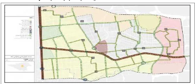
Map 1: Location of the studied area
Source: [13].
Research findings: Investigating the status of land use in the sixth area of Tehran
Latitudes of urban land use in the sixth area
Lack of suitable space for the organization of seasonal workers
The existence of defenseless urban areas and marginalization in the region;
The focus of the damage and social problems of the region in areas such as the margin of Hemmat and Chamran highways, Karim Khan bridge, Gandhi and Laleh Park
Low statistics on the identification and collection of street children from the region
Low statistics on the identification and collection of addicts from the region
The public transport facilities are getting worse; Lack of parking space in the area;
Inappropriate distribution of gardens in the region, number of existing gardens to the number of districts The very low green space share of the total green
space in Tehran relative to the area of the region Too much use of tanks in the passageways and mixed waste collection
Separation of household waste by inappropriate and non-sanitary methods along the way
Lower separation in the source of waste produced in the area
Inappropriate distribution of fruit and vegetable markets in neighborhoods
Physical compression in the south and east of the region around the main communication axes.
The total area of the area was six 2144.334 hectares, of which 34.44% was used for residential use, 27.6% for transportation, 22.31% for public welfare services, 8.8%
for working places, 2 to military land, 35/2 to land and not built, and eventually less than one percent to urban facilities. Per capita, based on the population of 23,104 people, residential per capita 23.33 square meters, work spaces and activities 7.72 square meters, general welfare services, 80.88 square meters, transportation and warehousing 26.76 square meters, military land 19.2 square meters, Urban utilities and 8 tenths of square meters and other unbuilt land were also 2.9 square meters. The total urban area of the area is six 81.81 square meters (Map No. 2).
Table (1): The most important land use weaknesses in the study area
Map 2: Land use in the sixth area of Tehran
Urban land use studies in the area of six Tehran indicate that, considering its location in the city center of Tehran, on the one hand, and the establishment of the most important administrative services of the service with the functional scale of transnational, urban and even national, pointed to, according to The existence of the most important universities in the country, as well as the Tehran Metropolitan Police Center, which is considered the capital of the capital of Iran, has a decent per capita in terms of educational services. Also, taking advantage of the fact that the metropolitan areas of Tehran metropolitan area in the sixth area, we see an increase in per capita and access to this user over time. The sixth municipality area of Tehran based on detailed regional design studies and its supporting documents, a region with a variety of functions and sustainable effects, is considered as an important part of the overall organization of the main space organization in Tehran. Also, its urban use is related to the activities and activities of the region, cultural, social, tourism, professional services - specialized and residential. As such, it is refined in combination with mixing, mixing and sequencing, and in line with the values and space requirements. The main activities of the development of the region based on the vision, goals and strategies of the detailed plan, with the goal of establishing, equipping and strengthening centers, functional areas and axes (elements of the functional index) have been
Tehran Karaj
Shahriar
Eslamshahr
developed at various scales. In this regard, maintaining and improving the quality of residential and residential identity of the region is also considered as one of the goals and strategies of the region's development. Also, providing sustainable income sources in the region has been proposed through utilizing the high quality and efficient spaces available and making money from construction costs is not considered. Considering the targeted goals and the forms completed by the experts in the field of mission in the six years of the program implementation, in the social and cultural sphere, the per capita increase of cultural and artistic spaces and per capita sports spaces through the construction of sports spaces and local neighborhoods. Also, the social deputy of the district will carry out effective measures to empower women at different levels, to preserve cultural and sports spaces, to keep the regional museums and to implement cultural and artistic programs. Establishment of the Haft Tir Square, the construction of parking lots at the district level, the completion of special bicycle tracks, as well as the necessary measures to maintain facilities and equipment, and training and upgrading the traffic culture of the most important measures taken by the Deputy Director of Transportation and traffic in the district this year. Can be In the field of urban services, the construction and development of green spaces and the design and implementation of a water supply network and the carrying out of affairs related to urban cleanness and dredging and maintenance of Qantas,
The area level in the years of implementation of the program is part of the foreseen activities for the urban services. Not. In the field of safety and crisis management, the design of a system for managing and Disposing of surface waters of Valiasr Street (Hemat to Motahari), in the field of urban planning and
Architecture of plans related to detailed design, in the field of management and intelligence, completion of class parking project and administrative building of the municipality of the sixth area on the agenda is located. In general, the six municipalities of Tehran, in the areas of transportation and traffic and urban services, have proposed extensive measures, and the proposed budget for urban services is higher than other areas indicating regional policy in the years of the program. In this regard, the preparation of Urban Development Strategy (CDS), Urban Operations Plans, Urban Development Strategic Development Plan, etc., all have a special look at the true development of the regions of this region and the Sides of the regions and, of course, the cities of the country.
The program is based on a new approach, which is in fact a combination of five year municipal program features and an operational plan.
In fact, the program actually carries out activities and actions of the municipality over the next five years based on prospects, goals, strategies, or should be the intermediate link of the comprehensive and detailed plans of the city and
The activities of the municipality of Tehran. This hierarchy will be completed from the level of prospects
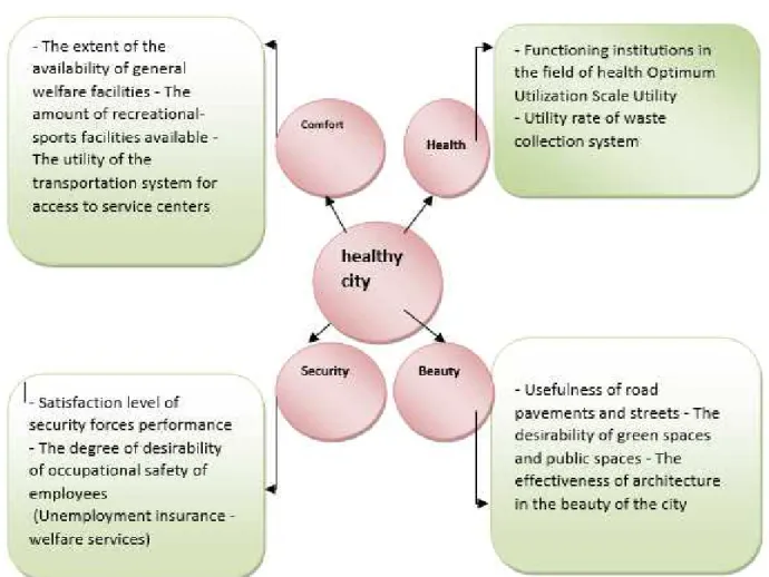
to projects and activities. In many of these cases, what is endorsed by urban planners and planners is the creation of a regional context for healthy city development. In order to achieve the vision of a healthy and sustainable city, which is also the goal of this paper, planning must take into account, first of all, the principles of urban planning, indicators and general objectives. In this study, according to the presented models, four key indicators of health, comfort, beauty and security are used, each of which consists of several components as follows: 1. Health (creation and promotion of health conditions and healthy environment-the correct use of land for certain uses)
2. Comfort (General facilities for the welfare of citizens, a place suitable for industrial and commercial investment, recreational facilities for spending leisure time)
3. Beauty (preserving the identity of the city-preserving the aesthetic manifestations in the design of all elements of the city)
14
In general, and according to studies and available information from different parts of the region, which is completely incompatible with the utility of land and according to citizens, the adjacency of transport users with the educational use that is highly visible in this area. And is in poor compliance with the standards. Another similar case in this area is the adjacency of therapeutic use with heavy traffic and traffic in some of the streets with health centers such as Imam Khomeini Hospital. In this regard, according to the patients' need for relaxation, the necessary standards in many places this area is not visible. These findings are in total the negative aspects of land use in the six metropolitan areas of Tehran, which is opposed to the indicators of the creation of the city of Hell.
Figure 3: The urban development strategy of the sixth area of Tehran
Figure 2: Different Dimensions of a Healthy City, Source:[4].
10. Citizen's perspective on the land use of the region and its place of residence
Today, in a local-urban management approach, there should be an appropriate interaction between people and authorities, and urban research should be based on measuring the needs and needs of citizens, and as long as the research does not seek to assess the need for citizenship, the real soul Research that ultimately leads to a reduction in problems and an increase in the quality of life of the people. Therefore, efforts should be made to find the required measurement and study in the region, and based on this, we will develop a codified program for building different spaces and needs. In this process, citizenship-focused approach should be emphasized in urban planning. Theoretical and practical contributions of citizens are emphasized. In this regard, studies of the urban development strategy of the six metropolitan areas of Tehran have been carried out and the present paper has studied the views of citizens in relation to their needs in the field of studies related to CDS from the sixth area and on the use of urban land in the sixth area. Accordingly, according to the citizens' opinion, the lack of facilities and urban infrastructure, the lack of suitable recreational and sports spaces, the delicacy of green space, the presence of large and small holes in pedestrians, poor urban furniture, the lack of proper colors in spaces Urban, noise and air pollution, the existence of a very visually sprawling space, especially in the area of Revolution Square, the existence of types of incompatible uses in the region, etc., are the most important issues and problems surrounding the use of urban land of the region.
In this regard, the author believes that the use of the land and its quality are essentially a central concept for regional, social and regional planning, and with concepts such as quality of life, diversity of social space, physical characteristics, activities, affiliations The location and identity of the city is connected. Self-dependence derives from positive and negative personal experiences in a particular location and historical, cultural, social, geographical, and environmental factors. Some planners also recognize the quality of the environment along with justice, compatibility, comfort and efficiency as one of the most important basic principles of urbanization in order to create a healthy, healthy city and control the spatial and visual distortions in the city. Kevin Lynch says: "The city is great for housing and living, and as a home must have the attributes and benefits to make its inhabitants' health and life comfortable and desirable, the city must also have qualities And features to provide health, comfort, and comfort to make life more prosperous and livelier (Lynch, 1995: Preface).But today, what we see about urban environments and urban planning in the region is the controversy with the issue of maintaining and sustaining the health of citizens and its confrontation with the surrounding environment. The topics discussed are all about the importance of urban
land use and the quality of planning for it. The CDS or Urban Development Strategy, with the philosophy behind the urban planning and urban planning and urban planning process, has a very important context in the field of urban-based urban reform and emphasis on urban land use. In this area, the importance and emphasis added to the program is the importance and involvement of people as the main users of land use and urban space. More clearly, it is meant that in previous urban development plans such as urban planning plans, detailed plans, comments and views of citizens, there was no involvement in the field of planning and land use. While it has been used to prepare Urban Development Strategy plans in other cities (Mahabad, Shahrekord, Azadshahr, etc.), the use of citizen's views and views on measuring urban development and how land is used is very important. Accordingly, it is clear that a view of the six metropolitan area of Tehran will also be used. Accordingly, according to the subject of this paper, the impact of the Urban Development Strategy Plan on land use that will take place in the future will be addressed.
11. Evaluating the development of the sixth area with emphasis on the use of urban land in the region
Various and varied functions ranging from metropolitan activities to housing, in a mixed and complementary manner within the framework of environmental carrying capacity;
The functions and activities of the region, while diversifying and mixing, combining and sequenced refinement, are proportional to the values and spatial requirements range.
The cultural, social, tourist, professional and specialized services and housing are among the obvious components of this arrangement.
The elements of the functional index (zones, axes, nodes and signs) are present in the region, which, with a synergistic relationship to the consistency of the situation, assist the region and the objective and subjective processes of the city and the citizens; The region, in terms of composition and social image,
enjoys a high level of social prestige, which enshrines and improves the social value of the local communities;
Inspirational Islamic Planning and Compatible Uses The elements of the economic, social and cultural
indicators existing in the region as factors of monitoring the quality of the urban environment help the regional management system and reduce the conflict;
The gravity of the region's financing system relies on the utilization of high-quality, efficient spaces. The range reflects the historical, cultural, and
political developments of the contemporary era of the Islamic Revolution
16
The focus of activities and public and semi-public spaces
An Effective and Sustainable Part in Crisis Management in Tehran Metropolis
The ideal range of mixing and synchronization of functions of residence, activity and leisure
12. Future Development Strategies in Six Municipality of Tehran
The development strategies of the region to realize the prospects and objectives for the region and in line with the strategies for developing a strategic (comprehensive) strategic plan (Tehran is developed as follows:
Equipping and designing axes and authorized areas of activity and mixed, especially in the southern and eastern halves of the region;
Stabilization of the region's population at a ceiling of 251 thousand people per year;
An increase in the number of workers in the region to about 331 thousand people per year;
Equipping and strengthening the routes and pedestrian network;
Improving the quality and functioning of the regional movement system through metro stations and public transportation;
Stabilization and equipping of green and open areas of the region as ecological refinement spaces; Equipping and strengthening the functional centers of the region;
Equipping and strengthening the functional centers of the region;
Avoiding the influence and interference of non-residential uses into neighborhoods;
Maintaining and improving the quality of housing and residential identity of the neighborhoods, especially in the northern and western halibut.
13. Conclusion and Compilation
Map 3. map of the proposed spatial organization in the 6th district of Tehran
Table 1: The dominant position of the Six Municipality of Tehran over time:
Row Supernatural documents The dominant role of the six municipality of Tehran
1 First Master Plan of Tehran (1347) The dominant role is residential, educational and recreational
2
Organization of Tehran (1992)
Considering the southern part of the region as the center of the service of the central area with the identity of the mold service in the category of the city and beyond the historical, cultural, commercial and tourist nature
3
Detailed Plans of Tehran Townships (1992)
Defining the region with a dominant cultural, administrative and commercial role
4 Strategic Plan of Tehran (1374) Specifically, area one has not been investigated 5 Detailed Plot of the Sixth District
of Tehran (2007)
A wide range of functions, as an important part of the central metropolis of Tehran metropolis
6
City Development Strategy of Sixth District of Tehran (1393)
Land use is the heart of urban planning, and its quality and quality are directly related to micro and macro planning strategies. Therefore, how to plan and use urban planning tools is very important in the current situation and the prospect of future land use planning. Urban planning and management has been the focus of many years since, and Urban Development Strategy (CDS) is the latest approach in this area, which was launched by the Coalition of Cities in 1999 jointly by the World Bank and the Settlement Center The human resources of the United Nations have been proposed for participatory management in the future of the city and transparency of the system. This approach has been studied in this paper regarding its impact on urban land use in six metropolitan areas of Tehran. According to the results of this study, which is based on documentary studies of this area as well as field surveys of citizens, it has been found that in addition to some unsuitable use of the category of healthy city, people have been using some urban utilization deficiencies such as elements Recreation and ..., it became clear that the use of urban landscapes, according to various urban development programs that have been used throughout history, has a very important place in the design of urban development strategy. So that in the combination of quantitative goals of areas in each area, attention has been paid to the activities carried out in the areas and targets. In this regard, in the social and cultural sphere, the development of spaces and cultural and social infrastructure, the development and equipping of the neighborhood, the development and equipping of recreational spaces, the development and equipping of sports spaces along with designs related to social, cultural and artistic activities. , In the field of transportation and traffic construction of passages and completion of the system of bicycles, pedestrian and pedestrian construction, Construction and development of inner-city terminals and plans related to the maintenance of facilities and traffic equipment and in the field of urban services. Construction and development of gardens and green spaces of urban roads, designing and implementing green spaces and irrigation networks and clean-up projects. And cleaning and urban beautification, maintenance of green spaces and maintenance of equipment related to urban affairs, each of which is a very important place in the field of urban land use.
FUNDING/SUPPORT
Not mentioned any Funding/Support by authors.
ACKNOWLEDGMENT
Not mentioned.
AUTHORS CONTRIBUTION
This work was carried out in collaboration among all authors.
CONFLICT OF INTEREST
The author (s) declared no potential conflicts of interests with respect to the authorship and/or publication of this paper.
References
1-Ashrafi, Yousef (2009), (CDS, A New Approach to Urban Planning in the Analytical Approach, Urban Management Schedule), Seventh Year, No. 23, Organization of Municipalities and Departments of the Country, pp. 104-88.[Scholar]
2- Piran, Parviz (1369), (Theoretical Perspectives in City Sociology and Urbanization (School of Political Economy of Space), Journal of Political-Economic Information, Fifth Year, No. 40).[Scholar]
3-Ziari, Karmateh, Mahdanezhad, Hafez and Faryad Parjiz (2009), (The basics and techniques of urban planning), International University of Chah Bahar, First edition.[Scholar]
4-Lotfi, Sedigheh, Mehdi, Ali and Masoumeh Mehdian Behnamiri (2004), Evaluation of Healthy City Indicators in the City of Qom, Quarterly Journal of Social and Cultural Development Studies, Jabd. 1, No. 2, pp. 98-76.[Scholar]
5- Seyyednia, Ahmad (2004), (Urban Management), Publications of the Municipality and Dehariyah Organization, Third Edition, Tehran.[Scholar] 6-Advisor Engineers (2003), Development of
Appropriate Methods for Urban Planning in Iran, Publications of the Municipal Organization of Iran, Tehran.[Scholar]
7-Al-Ahmadi, Khalid, See, Linda, Heppenstall, Alison, Hogg, James (2009), “Calibration of a fuzzy automata model of urban dynamics inSaudi Arabia”, Journalhomepage:www.elsevier.com/locate/ecocom , pp 80-101.[Scholar]
8-Butala,Neel M,Michael J.VanRooyen ,Ronak Bhailal Patel ,(2010) ,Improved health outcomes in urban slums through infrastructure upgrading, journalhomepage:www.elsevier.com/locate/socscim ed, Social Science & Medicine 71. pp 935- 940. [Scholar]
9-City Development Strategy, World Bank Report, (2000),www .cdsea .org .[Scholar]
10- Cities Alliance, (2008), Guide City Development strategies, UNCHS.[Scholar]
18
12- Jim C.Y and WendyY, Chen (2010), “Habitat effect on vegetation ecology and occurrence on urban masonry walls”,Journal homepage: www .elsevier. de/ufug , pp 169-178. [Scholar]
13- Saeedi, M. (2017). Study the Effects of Construction’s New Techniques and Technologies on Time, Cost and Quality of Con-struction Projects from the Perspective of Construction Management. Journal of Civil Engineering and Materials Application, 1(2), 61-76.[Scholar]
![Figure 1: CDS Synchronization Process Synchronization Process Source: [11] In fact, eye-catching, he tries to answer the question that](https://thumb-us.123doks.com/thumbv2/123dok_us/8078822.2140348/3.892.89.417.241.671/figure-synchronization-process-synchronization-process-source-catching-question.webp)