Automatic Accidental Analysis and Location
Finding For Navigation Security
I
Priya Dhokne,
IIProf. S.B. Rothe
IPG Student (M.Tech VLSI), Dept. of Electronics and Telecomm., GHRIETW, Nagpur, Maharastra, India
IIDept. of Electronics and Telecommunication, GHRIETW, Nagpur, Maharastra, India
I. Introduction
The purpose of planning the project is to find out the accurate and proper location of ship and closely acquainted the position of ship to the concerned authority. In this unit work the location of the ship can be track by interacting and interfacing different types of sensors , temperature sensor and vibration sensor in a manner to track location of ship and in a appropriately manner and take different measures against accidents.
This system unit indulges a GPS module which redeems the location of a ship in relative terms of its latitude and longitude. This whole data is given to the ARM LPC 2148 Microcontroller that is connected with a GSM unit of module. Microcontroller redeem the details of location from the GPS unit and sends it to the corresponding authority over GSM module unit this convenient information is available at the base station in regular manner and in proper intervals that is set by the user, and thus gives the relevant information about the location of ship. An LCD unit is interfaced to display in the microcontroller unit so that the data proper data is received before it being sent over GSM and give the information about the location of the ship and in accordance to this it displays the message, so that the whole information will be available at the base station.
The proposed work is design as technical assessment is concern to search out the proper and exact location of ship and give the basic information about the position of ship to the apprehensive base station. In this suggested work the system uses different sensors to find and track the parameters of accident. This interacted sensor analyses the problems in ship all the problem that appeared due to cold and burning and ship misalignment. This GPS module unit is connected with that ofthe MAX232IC. These
GPS module provides the location ofthe ship in duration of the latitude and longitude,. The connected microcontroller asset the information detail from the GPS module and give and sends it to the appropriate and particular station through the GSM module. And this information is available at the base station at every time of moment. An LCD display is used which is used to display the information about the location of ship.
This system unit of design is having sensors able to be used with module thus they can be act as necessary measures for accidents in ship. And in these their present a base stations where we can send and store the appropriate information related to the system. This system uses good processor to complete the respective task. The favourable purpose of this project is that it helps to regulate and avoid the ship accidents. Also we can take providing action against accident.
II. Hardware Design
The basic structure of Hardware for the tracking of ship is shown in Figure1. This system pattern holds a microcontroller, GPS, GSM modem and LCD display unit and all system is placed on a respective ship. This tracking system provides To accomplish a purpose of tracking of ship and accordingly displays the message. The sensors available with this module unit issue the considerable information about the ship and problems that are being faced by the ship. The Global Positioning System (GPS) is focuses on the study of navigation and controlled and monitored the system that gives and provides the location and all timing related information in all basic condition this receiver is being placed on the ship and is connected with that of the MAX232IC. A microcontroller recovers all the information detail from the unit of GPS module and sends
Abstract
The project is being carefully thought and deliberated and thus created an accidental solution by analysing, detection and tracking of ship and is operated by GPS. This project helps us to reduce the accidental problems in ship and in many of cases it will be convenient to take safely and preventive measures against accident by establishing the ship such as changes in temperature against burning and
cold, fire catches in ship and changing in alignment of ship because of vibration in the ship and finding of last location of ship that is
where ship is available in the sea. The intention behind to create this project is that, intended tracking of ship will be possible and we can come to know the position and status of ship i.e. location of ship , its changing alignment and available temperature which will help us to
indicate and sort out accidents of ship, their basic causes and location finding of ship. In this design whatever will bw the status available
on the ship, get fully read with the help of some related sensors. This pre-analysis comprises the status of the sensors that means if
fire occurred in the ship then this information
The sensors perceive by the sense the problems in ship such as problem of temperature that changes in anticipation of cold and is
inconvenient for machineries in the ship, improper vibrations in the ships and fire that catches in ship thus we can able to know
whether ship is in proper condition or is affected by any damage and as a result take measures in anticipation of accidents. All necessary information are made available at the device that is located on the ship and transmits all the appropriate information by the transmitter and all information is get collected it at the receiver. All the necessary information that is received is considerably enough to check problems in ship. This system indulges a GPS unit of Module that is used to track corresponding location of the
ship. This GPS unit specified for global positioning system, this system uses to find the proper location of the ship and familiar the
position to the concerned authority.
Keywords
it to the individual and each of the particular base station through the unit of GSM modem. And LCD display is interfaced that is used to display the respective message about the ship.
Fig. 1: Block Diagram
Fig. 2: Receiver unit
Fig. 3: Transmitter Unit
Fig. 4: Receiver Mobile unit.
This project uses sensors
The ARM LPC2148 controller unit •
GPS Module unit •
GSM Modem unit •
MAX232IC •
Display of 16*2 LCD units. •
Power Supply Unit. •
Temperature sensor (LM 35) unit. •
Vibration Sensor unit. •
The planned project uses ARM - LPC 2148 microcontroller unit that is used for processing all the respective things i.e. collection of whole information from the respective sensors i.e. temperature sensor, vibration sensor and all related information of location from GPS Module unit. This information is being collected and transmitted with the help of GSM Module unit. And finally the related information will be reach at the receiver mobile phone unit.
A. GSM Module
GSM (Global System for Mobile communications). GSM unit is a digitized cellular mobile system for communications. It is used for transition of service of data and service of mobile voice. It is having the roaming capability internationally. It has capability to protect the digital data confidentially so that the messages can be read only the authorized party for information privacy and security purpose. It is having Better security in opposition of deception.
B. GPS (Global Positioning System)
The Hardware interfaces GPS receiver unit on the ship. GPS module has a pretty good sensitivity and excellent tracking capability even in urban condition. It is one of the novel methods which are used for the ship tracking alongside with the DGPS (Differential Global Positioning System) it forms a triangulation to find the exact and precise location of the object. The smart unit of GPS antenna can track up to 32 satellites at a time by presuming fast timing to first fix, and second one navigation get updated and consuming low power. It will provide with high sensitivity and performance even in rural area canyon and in heavy collectively environment. It is having far reaching capability needs the sensitivity requirement of ship navigation and gives location and through all this the information is available at the base station in continuous manner at every moment.
Fig. 6: Receiver unit
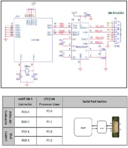
The Global Positioning System (GPS) is a satellite space based process used for monitoring and controlling system that issues location and all time information in all situations, anywhere on the Earth, where there is not obstructed line of sight to four or more satellites. This Fig. shows how to interact with the GPS module with microcontroller unit. The GPS unit of module consistently transmits the data serially in the protocol RS232 in the form of standard of sentences in NMEA standards. The position of latitude and longitude values of the location is preserved in the sentence of GPGGAin the format of NMEA. We have to need three corresponding signal to communicate through UART or USART, that is RXD pin is used to receive, TXD is used to transmit, GND is used for common ground.
And if we want to receive the respective data from that of the satellite to the microcontroller unit LPC2148 by used of the GPS module that is connected through the port 0 of UART0. The data is serially taken from the unit of GPS module through MAX232 into the register of SBUF that is connected to the microcontroller. The serial data is taken from the unit of GPS receiver by using the controller of serial interrupt.
Fig. 7: Interfacing diagram.
D. Temperature sensor
The associated sensors is used to discover and identify the temperature that arises in conceptual contrast to cold and burning, the LM35 series provides the quality condition combining the circuit temperature sensor and it has analogous output which is used resembling a line that is proportional to the temperature surrounding. The LM35 sensor has very low impadences and resembling the output and the action of callibrating makes interacting and makes the control circuitry. It can be used as a supply voltage and output is rectifying in design and connection is operated at a range of temperature having a range of -55c to +150c. The consisting of temperature can have a range of +10.0mv/c scale factor and it has very low ability of self heating.
Fig. 8: Temperature sensor
E. Vibration sensor
frequencies. LDTM-028K is a scalar component consisting of a 28 um thick film of piezoelectric PVDF polymer that are printed in screen Ag-ink electrodes, that is laminated to a 0.125mm polyster solid substrate, and is fitted in between two compress contacts. This is having low cost of vibration sensor.
Fig. 9: Vibration sensor
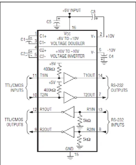
III. MAX232IC
The MAXIC is connected to the microcontroller unit the family of MAX220–MAX249 is connected to the line of dual drivers and dual receivers is intended for all EIA/TIA-232E, and is applicable for particular applications where ±12V of voltage is not available. All the MAX220-MAX249 are offered in all different 26 packages having different temperature ranges from 0 to +70°C up to -55°C
to +125°C. Fig. 10: MAXIC Unit
In this system design of planned work the unit of GPS is interacted and connected to that of the MAX232IC and all these unit is placed onto the ship. This MAX232 IC device consists as a dual driver and dual receiver that indulge a voltage generator of capacitive that is used to give level of supply voltage of TIA/EIA-232-F levels of voltage levels with a single power supply of volatge 5-V supply. And particularly Each of the receiver get converts TIA/ EIA-232-F of input levels to 5-V TTL/CMOS levels. All This meets or exceeds the voltage level of TIA/EIA-232-F. all This operated up to 120kbits/s. This MAX232IC has two daul drivers and two receivers. The dual receiver is havimg a threshold voltage of 1.3v, and is having a typical voltage of 0.5v and it can accept an input voltage of +30v. Each of the two drivers get converts input levels of TTL/CMOS into TIA/EIA-232-F levels. It is having low supply of current typically of 8milli-ampere.
IV. ARM LPC 2148
mechanism are much simpler than those of micro programmed Complex Instruction Set Computers i.e.(CISC). This being simple quality those results in a very high and magnificent instruction the amount of material to be carried in a real-time interrupts Response and is resulting from a small and effective to cost processor core. These technique of Pipeline are make use of so
that all parts of the
Processing and memory systems can be operated continuously. It is one of the nature of , while executing one instruction, its successor is being decoded known as Thumb, and it makes and is preferably suited for high-volume applications with memory restrictions, and is used in applications where density of code is an issue. The basic and key idea behind this Thumb is that of a super-reduced instruction set.
Fig. 11. ARM Processor
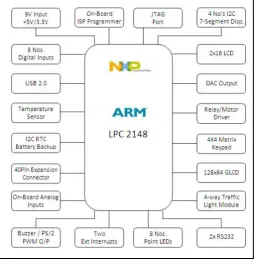
This family of ARM7 is the world’s extensively used processor of 32-bit embedded family. The ARM processor is the most provider in industry’s of embedded microprocessors. There are more than 30 billion processors that are already created and is in excess of 16 million shipped every day. The 16 and 32-bit of ARM7TDMI-S microcontroller is a small and tiny package of LQFP64 package. It consists of flash memory of 512 kB of on-chip program memory. It is having a Single 10-bit D/A converter that provides different analogous output. It is having Multiple interacted with the serial interfaces that includes two UARTs, and two Fast I2C-bus and variable length of data capabilities. It is having a Two 10-bit A/D converters that provides a total of 8 analogous inputs, and is having conversion times as low as 2.44 μs per channel speed of 60 MHz operation.
Testing of the GPS with the controller unit LPC2148:
It Gives a supply voltage of +3.3V power supply and is given to primer board of LPC2148; and is connected to voltage supply of +5V adapter with GPS unit of module and is connected with the LPC2148 Primer Board.
This sensor of piezoelectric is used as detection of accident sensor. This piezoelectric transducer has very high output DC impedance and can be imitate as a consistent voltage source
and filter network. The output signal is then related to this mechanical force as if it had passed through the equivalent circuit.
Fig. 12: Circuit Diagram
This planned of project uses the microcontroller ARM - LPC 2148 unit for performing all the things i.e. collection of all data information from the sensors i.e. temperature sensor, vibration sensor and finding location relating information from that of the GPS Module. This all the information get collected and transmitted with the help of GSM Module unit. This GSM unit of Module in also interface and interacted with that of the ARM - LPC 2148 controller unit. Thus To interface and interacted with the GPS unit of Module and GSM Module unit with ARM - LPC 2148 controller and is used with that of the MAX 232IC. To give power to the microcontroller unit, GPS unit, GSM Unit we are using multiple power supply as per individual unit’s requirements. And accordingly all the related information will be reach at the receiver unit of mobile phone.
Fig. 13: Power supply
V. Conclusions
be used for the future need and future requirement and is more coherent for the safety purpose.
VI. AcknowledgEment
The Author likes to have an obligation in gratitude of favor to Prof. S.B. Rothe Sir (Assist. Professor of Department of Electronics and Telecommunication System, GHRIETW, Nagpur, Maharashtra) for presuming his timely opinion and offers a guidance.
References
Elia Nadira Sabudin, Siti Zarina Mohd Muji, Mohd. Helmy [1].
Abd Wahab, Ayob Johari, Norazman Bin Ghani,“GSM-based
Notification Speed Detection for Monitoring Purposes”, IEEE, Department of Computer Engineering, University
Tun Hussein Onn Malaysia in 2008.
M. AL-Rousan, A. R. AI-Ali and K. Darwish “GSM-Based
[2].
Mobile Tele-Monitoring and Management System for Inter-Cities Public Transportation”, International Conference on Industrial Technology (ICIT), Computer Engineering Dept., American University of Sharjah, UAE in 2004, pages
859-862.
Stephen Teang Soo Thong, Chua Tien Han and Tharek
[3].
Abdul Rahman “Intelligent Fleet Management System with Concurrent GPS & GSM Real-Time Positioning Technology”, IEEE ,Wireless Communication Centre (WCC), universiti Teknologi Malaysia (UTM), Malaysia in 2007.
Wright, M., Stallings, D., Dunn, D.: The Effectiveness of
[4].
Global Positioning System Electronic Navigation. April
2003, IEEE Southeastcon 2003. Bridging the Digital Divide.
Renaissance Jamaica Granade Resort Ocho Rios, St. Ann, Jamaica W.
Li Liu, YanfangJing, Zengxiao Chi, JianBangChen, ChaoMa,
[5].
“Design and implementation of Android Phone Based Group
Communication and Navigation System”, 2nd International Conference on Consumer Electronics, Communications and Networks 2012, 21-23 April 2012, pp 3174-3177, ISBN:978-1-4577-1414-6.
ShresthaR, YaoAihong, “Design of Secure Location [6].
and Message Sharing System for Android Platform”, International Conference on Computer Science and Automation Engineering, Zhangjiajie,Vol1, 25-27 May 2012, pp 117-121, ISBN:978-1-4673-0088-9.
Al-Suwaidi G B, Zemerly M J, “Locating Friends and Family [7].
Using Mobile Phones With Global Positioning System (GPS)”,International Conference on Computer Systems
and Applications, Rabat, 10-13 May 2009, pp 555-558,
ISBN:978-1-4244-3807-5.
Grewal, Mohinder S., Lawrence R. Weill, and Angus P. [8].
Anderews. “Global Positioning Systems, Inertial Navigation, and Integration”. New York, NY: John Wiley & Sons, Inc.2001
Lita, I. B. Cioc and D. A. Visan, “A New Approach of
[9].
Automobile Localization System Using GPS and GSM/GPRS Transmission,” in Proc. Int. Spring Seminar on Electronics
Technology, 2006, pp. 115- 119.
T. K. Kishore, T. S. Vardhan, and N. L. Narayana, “Vehicle
[10].
Tracking Using a Reliable Embedded Data Acquisition Sysytem With GPS and GSM”, Int. Journal of Computer