i
Headquarters Department of the Army Commandant, US Marine Corps Washington, DC, 26 January 1998
River-Crossing Operations
TABLE OF CONTENTS
Page Preface... vi
Chapter 1. Concepts ... 1-1
General... 1-1 Types of Crossings ... 1-1 Hasty ... 1-1 Deliberate ... 1-3 Retrograde ... 1-4 Crossing Fundamentals ... 1-4 Surprise ... 1-4 Extensive Preparation ... 1-4 Flexible Plan... 1-5 Traffic Control ... 1-5 Organization ... 1-5 Speed... 1-6
Chapter 2. Terrain and Enemy ... 2-1
General... 2-1 Estimate of the Situation... 2-1 Tactical Requirements ... 2-1 Terrain ... 2-1 Characteristics ... 2-1 Military Aspects ... 2-2
ii
Page Current ... 2-2 Water Measurements... 2-2 Water Changes... 2-3 Obstructions ... 2-3 The Friendly Shore ... 2-4 The Enemy Shore... 2-4 Intelligence ... 2-5 Priority Intelligence Requirements (PIR)... 2-6 Information Collection ... 2-6 Threat ... 2-6 River Defense ... 2-6 Offensive River Crossing ... 2-8
Chapter 3. Command and Control ... 3-1
General ... 3-1 Organization ... 3-1 Control Elements... 3-1 Division Headquarters... 3-1 Brigade Headquarters ... 3-3 Communications... 3-5 Control Measures ... 3-5 Release Lines (RLs)... 3-5 Crossing Areas ... 3-5 Waiting Areas... 3-5 Engineer Equipment Parks (EEPs) ... 3-10 Traffic-Control Posts... 3-10 Engineer Regulating Points ... 3-10 Crossing Plan ... 3-10 Crossing Control... 3-11 Assault Across the River... 3-11 Crossing-Area Operations ... 3-11 Transfer of Support Forces to Division ... 3-12 Movement Control... 3-14 Retrograde Crossings ... 3-14
Chapter 4. Planning ... 4-1
iii
Page Chapter 5. Division Deliberate River Crossing ...5-1
General... 5-1 Phases of a Deliberate River Crossing ...5-1 The River Crossing ...5-1 Advance to the River (Phase I) ...5-4 Assault Across the River (Phase II) ...5-6 Advance From the Exit Bank (Phase III) ...5-8 Secure the Bridgehead Line (Phase IV) ...5-9 Continuation of the Attack ... 5-11
Chapter 6. Retrograde Operations ...6-1
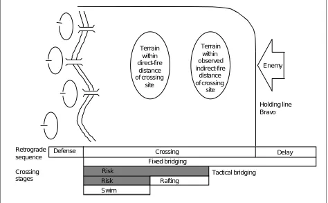
General... 6-1 Retrograde Types...6-1 Delay ... 6-1 Withdrawal ...6-6 Retirement ...6-6 Denial Measures ...6-6 Planning ... 6-7
Chapter 7. Crossing Sites...7-1
iv
Page Bridges ... 7-13 Site Organization ... 7-14 Night Operations... 7-15 Actions Under Fire... 7-15 Vehicle Recovery ... 7-16 Other Gap-Crossing Equipment... 7-16
Chapter 8. Assault Crossing ... 8-1
General ... 8-1 Types of Assault Crossings ... 8-1 Rubber-Boat Crossing... 8-2 Air-Assault Crossing... 8-2 Vehicle-Swim Crossing ... 8-3 Organization ... 8-3 Support Force ... 8-3 Assault Force... 8-4 Engineers... 8-7 Preparation Phase of the Operation... 8-7 Far-Shore Reconnaissance ... 8-7 Far-Shore Preparation... 8-8 Nearshore Reconnaissance ... 8-10 Assault-Force Rehearsal... 8-10 Execution Phase of the Operation ... 8-11 Attack-Position Procedures ... 8-11 Embarking Procedures ... 8-12 Tactical Control Afloat... 8-13 Watermanship... 8-14 Obscuring With Smoke ... 8-16 Direct-Fire Reaction... 8-17 Indirect-Fire Reaction... 8-17 Debarking Procedures ... 8-17 Boat Return ... 8-17 Motor Procedures ... 8-18 Cargo Procedures ... 8-19 Casualty Procedures ... 8-19 Safety ... 8-20
Chapter 9. Engineer Operations ... 9-1
v
Page Engineer Contingency Bridging Operations ... 9-4 Assault Bridges, Long-Term Use ... 9-5 Maintenance ...9-5 Anchorage ...9-5 Protective Systems ...9-6 Approaches ...9-7
Long-Term Gap-Crossing C2...9-8
Multirole Bridge Company (MRBC) ... 9-8 Organization ...9-9 Basic Concept ...9-9 Implications ... 9-10 Training ... 9-10
Appendix A. Metric Conversion Chart ... A-1
Appendix B. Engineer-Planning Calculations ... B-1
General... B-1 Engineer Planning... B-1
Appendix C. Crossing Means ... C-1
vi
PREFACE
Field Manual (FM) 90-13 describes how divisions and brigades conduct river crossings. It shows the relationship to corps operations, where appropriate, and includes details for lower echelons to support the brigades. It provides doctrine, tactics, techniques, and procedures (TTP) in one reference to accomplish this special operation.
The corps assigns missions and provides the necessary support and equipment. The divi-sions normally assign bridgehead objectives and control movement across the river. The bri-gades are the bridgehead forces that execute the crossings, either independently or as elements of a larger force.
River-crossing skills and knowledge are highly perishable. As with many other tactical oper-ations, they require constant practice in planning and execution. There are relatively few opportunities to train with the frequency needed to keep a high degree of proficiency in this tough operation. For that reason, this manual includes considerable detail on techniques and procedures.
A river crossing is a special operation in that it requires specific procedures for success because the water obstacle prevents normal ground maneuver. It demands more detailed planning and technical support than normal tactical operations. It also features specific con-trol measures to move the force across a water obstacle. This obstacle may be a river, a lake, or a canal. Unlike other obstacle types, the water obstacle remains effective during and after the crossing operation. See FM 90-13-1 for other counterobstacle operations.
As in the past, the United States (US) Army conducts river crossings within the context of its basic doctrine. This manual applies the current Army-operations doctrine described in FM 100-5 to river crossings. It incorporates recent developments in command and control
(C2) for command-post (CP) facilities and the military decision-making process. It also aligns
US doctrine more closely with ongoing standardization efforts in the North Atlantic Treaty Organization (NATO).
Appendix A contains an English to metric measurement conversion chart.
The proponent of this publication is HQ TRADOC. Send comments and recommendations on Department of the Army (DA) Form 2028 directly to Commander, US Army Engineer School, ATTN: ATSE-TD-D-WC, Fort Leonard Wood, MO 65473-6650.
This publication implements the following international agreement: Standardization Agree-ment (STANAG) 2395, Edition 1, Opposed Water Crossing Procedures.
Concepts 1-1
CHAPTER 1
Concepts
GENERAL
The purpose of any river crossing is to project combat power across a water obstacle to accomplish a mission. A river crossing is a unique operation. It requires specific proce-dures for success because the water obstacle prevents normal ground maneuver. It also requires detailed planning and control mea-sures and different technical support than other tactical operations require. The nature and size of the obstacle, the enemy situation, and available crossing assets limit the tacti-cal commander's options.
The challenge is to minimize the river's impact on the commander's ability to maneuver. The force is vulnerable while
crossing, as it must break its movement formations, concentrate at crossing points, and reform on the far shore before continu-ing to maneuver. The tactical commander cannot effectively fight his force while it is split by a river. He must reduce this vul-nerability by decreasing his force's expo-sure time. The best method is to cross rivers in stride as a continuation of the tac-tical operation, whether in the offense or retrograde. Only as a last resort should the force pause to build up combat power or crossing means before crossing. This chapter introduces river-crossing opera-tions by discussing the characteristics of this special, difficult, and dangerous task.
TYPES OF CROSSINGS
Units expected to conduct a river crossing anticipate and plan for it in advance. All river crossings require detailed planning. The planning requirements and engineer technical support are similar, whether the crossing is hasty, deliberate, or retrograde.
HASTY
A hasty river crossing is a continuation of an attack across the river with no inten-tional pause at the water to prepare, so that there is no loss of momentum. This is possi-ble when enemy resistance is weak and the river is not a severe obstacle.
A hasty river crossing is preferable to a deliberate crossing. A hasty river crossing features decentralized control at the bri-gade level. The bribri-gade may use organic, existing, or expedient crossing means, but additional support from the division or corps is often necessary due to the bridge
companies being controlled at corps level. That support is only available when those headquarters have taken purposeful action to position the assets at the right time and place to make a brigade hasty crossing fea-sible. Coordination for support must be made early in the planning process.
1-2 Concepts
Hasty Dry-Gap Crossing
Antitank (AT) ditches and craters are nor-mally what maneuver forces encounter as a dry-gap-crossing obstacle. Dry riverbeds may also present a crossing problem. Maneuver forces can use the M9 armored combat earthmover (ACE) to push down the sides of ditches or to fill in craters. Substan-tial fill material placed in the dry gaps allows the passage of combat tracked vehi-cles. The crossing site can be improved and maintained for wheeled-traffic use by fol-low-on forces.
The armored vehicle-launched bridge (AVLB) is particularly suited for spanning stream-beds, AT ditches, craters, canals, partially blown bridges, and similar obstacles. It can be launched and recovered in less than 5 minutes. The AVLB, like the M9 ACE, is organic to combat engineer companies for use in hasty crossings of short gaps. The AVLB should be left in place across the gap only as long as it takes to cross the maneuver unit it is traveling with, then replaced with other fixed bridging, if necessary.
Hasty Wet-Gap Crossing
The depth and width of the wet gap, bank conditions, and the current’s velocity will determine if the maneuver force can cross by fording, swimming, or employing the AVLB or if other bridging assets are required. Identifying wet gaps early and deploying the required resources allow hasty crossings of known or anticipated gaps to occur. Two factors should be consid-ered when swimming vehicles through wet gaps—the current’s velocity and the bank conditions.
Because vehicles drain rapidly when exit-ing, initially firm banks tend to deteriorate rapidly from multiple uses of the same exit point. The existence of mud or surface irreg-ularities further degrades the percent of the
slope that the swimming vehicle can over-come. When selecting a fording site in a wet-gap crossing, the depth of the water is the most significant factor. The depth of the water in one crossing area may change due to bottom surface mud or irregularities (boulders or pot holes). The AVLB is ideally suited to allow hasty wet-gap crossings, requiring only that the supported maneuver force eliminate enemy direct and observed indirect fires. The crossing means will need to be replaced by other bridging assets as soon as possible to allow the AVLB to remain with its supported unit.
If possible, the force crosses the water obstacle at multiple points across a broad front. It makes the crossing as soon as its elements reach the obstacle, whether by day or night. As the bulk of the force crosses the water, minimum forces remain to secure the crossing sites.
Expedient crossing means may be used if readily available and can be transported to the crossing site. The reconnaissance party should note material or existing features that could be used as expedient crossing devices. These include culvert pipe, lumber or cut timber, or war-damaged equipment. The pipe fascines system (PFS), which con-sists of bundles of 8-inch, high-density, plas-tic pipes chained together, can fill gaps up to 9 meters deep and support up to 70 tons. The PFS is transported by an AVLB after the bridge is downloaded and emplaced into the gap.
Concepts 1-3
When facing negligible or light enemy resis-tance on both banks, the force does not have to clear all enemy forces from the river to conduct a hasty crossing. It capitalizes on the speed of the crossing and the limited ability of the enemy to effectively oppose the crossing.
DELIBERATE
A deliberate river crossing is conducted when—
• A hasty crossing is not feasible. • A hasty crossing has failed.
Opposition from a strong defending enemy can require a deliberate crossing. A deliber-ate river crossing is an attack across the river after a halt to make the detailed prep-arations necessary to ensure success. It is characterized by—
• A significant water obstacle. • Strong enemy resistance.
• The necessity to clear entry and/or exit banks of enemy forces.
A deliberate river crossing involves the fol-lowing:
• Centralized division planning and control. • Thorough preparations, to include the time to perform extensive reconnais-sance and full-scale rehearsals, develop alternate traffic routes, and stockpile logistics.
• The massing of forces and crossing equipment.
The deliberate river-crossing organization is as follows:
• An assault force that seizes the far-shore objective and eliminates direct fire on the crossing site.
• A maneuver-support force that consists of corps combat engineers, bridge com-panies, military police (MP), and chemi-cal units which provide crossing means, traffic control, and obscuration.
• A bridgehead force that attacks from the far-shore objective to secure the bridge-head, eliminating direct fire and observed indirect fire on the crossing area.
Once the river crossing is complete (bridge-head line is secured), a breakout force crosses the river behind the bridgehead force and attacks out of the bridgehead. This force is normally not a part of the unit that conducted the river crossing.
The two types of deliberate crossings are wet- and dry-gap crossings.
Deliberate Wet-Gap Crossing
The deliberate wet-gap crossing is divided into the following three phases: assault, rafting, and bridging. These phases may occur in sequence or concurrently. The objective in deliberate wet-gap crossings is to project combat power to the exit bank at a faster rate than the enemy can concen-trate forces for a counterattack. To do this, the commander may elect to first construct rafts for nonswimming vehicles while swim-ming the fighting vehicles across. Bridge construction is started when observed indi-rect fire has been eliminated. If the tactical situation allows the elimination of the raft-ing phase, bridgraft-ing efforts should begin immediately. This may be a suitable option considering the high speed of employing systems like the ribbon bridge.
Deliberate Dry-Gap Crossing
1-4 Concepts
preferred. The MGB, the Bailey bridge, the M4T6 dry-span bridge and, in the near future, the heavy dry-support bridge (HDSB) are used to span larger dry gaps. These assets are labor-intensive and expose personnel to enemy fire during con-struction but provide stable gap-crossing support for continuous operations.
RETROGRADE
A retrograde river crossing is a movement to the rear across a water obstacle while in
contact with the enemy. The forces con-ducting the crossing establish a defense on the exit bank or continue the retrograde to the defensive positions beyond the water obstacle. A retrograde river crossing fea-tures centralized planning and control because of the limited crossing means. It has the same amount of detailed planning as for a deliberate offensive crossing. Fail-ure of a retrograde crossing may lead to losing a significant amount of friendly forces.
CROSSING FUNDAMENTALS
River-crossing fundamentals are the same for all river crossings, but their application varies. For example, traffic control is a key fundamental. The commander maintains it in a hasty crossing by using the unit’s SOP and a fragmentary order (FRAGO). In a deliberate crossing, he uses a traffic-control organization, such as the MP, that imple-ments a detailed movement plan. Crossing fundamentals must be applied to ensure success when conducting a river crossing. These fundamentals include—
• Surprise.
• Extensive preparation. • Flexible plan.
• Traffic control. • Organization. • Speed.
SURPRISE
The range and lethality of modern weapons allow even a small force to defeat a larger exposed force caught in an unfavorable posi-tion. A river provides this possibility by—
• Limiting a force to a small number of crossing sites.
• Splitting the force’s combat power on separate banks.
• Exposing the force to fires while on the water.
Surprise minimizes these disadvantages; forces that fail to achieve surprise may also fail in the crossing attempt.
A deception plan is a key element of sur-prise. It reinforces the enemy's predisposi-tion to believe that the force will take a particular course of action (COA). The enemy usually expects a crossing; however, it does not know where or when. A deception plan that employs reconnaissance, site prep-arations, force buildup, and preparatory fires at a time or location other than the intended crossing area may delay an effec-tive enemy response to the true crossing. The usual operations security (OPSEC) mea-sures are also important. Commanders enforce camouflage, noise, thermal, electro-magnetic, and light discipline. In particular, commanders closely control movement and concealment of river-crossing equipment and other obvious river-crossing preparations. Despite modern intelligence-gathering technology, the skillful use of night, smoke, fog, and bad weather for obscuration is still effective.
EXTENSIVE PREPARATION
Concepts 1-5
terrain must be developed early, since plan-ning depends on an accurate and complete intelligence picture.
Supporting forces, which typically include engineer battalions, bridge companies, air-defense batteries, smoke-generation compa-nies, and MP compacompa-nies, must link up early. They immediately begin crossing prepara-tions and are available to train the crossing force during rehearsals.
Commanders plan and initiate deceptive operations early to mask the actual prepa-ration. These operations should conceal both the time and location of the crossing, so they begin before and continue through-out the preparation period.
Work necessary to improve routes to handle the traffic volume of the crossing operation should occur early enough not to interfere with other uses of the routes. This requires a detailed traffic plan carefully synchro-nized with the deception plan.
Full-scale rehearsals are essential to clarify roles and procedures, train personnel, inspect equipment, develop teamwork, and ensure the unity of effort.
FLEXIBLE PLAN
Even successful crossings seldom go accord-ing to plan. A flexible plan enables the crossing force to adapt rapidly to changes in the situation during execution. It allows the force to salvage the loss of a crossing site or to exploit a sudden opportunity. A flexible plan for a river crossing is the result of thor-ough staff planning, not chance. Such a plan features—
• Multiple approach routes from assembly areas (AAs) to crossing sites.
• Lateral routes to redirect units to alter-nate crossing sites.
• Alternate crossing sites and staging areas to activate if enemy action closes the primaries.
• Crossing equipment held in reserve to replace losses or open alternate sites.
TRAFFIC CONTROL
A river is a significant obstacle that slows and stops units, thus impeding their ability to maneuver. Units are restricted to moving in column formations along a few routes that come together at the crossing sites. Traffic control is essential to cross units at the locations and in the sequence desired. Maximum crossing efficiency is achieved through traffic control. It also prevents the formation of targets that are susceptible to destruction by artillery or air strikes. In addition, effective traffic control contrib-utes to the flexibility of the plan by enabling commanders to change the sequence, timing, or site of crossing units. The traffic-control organization can switch units over different routes or hold them in waiting areas as directed by the tactical commander.
ORGANIZATION
Commanders use the same C2 nodes for
river crossings as they do for other opera-tions. These nodes, however, take on addi-tional functions in river crossings. For this reason, commanders specify which nodes and staff positions have specific river-crossing planning and control duties. This may require some temporary collocation of headquarters cells (or individual augmenta-tion) and an increase in communications means.
1-6 Concepts
units, into a crossing organization. This organization reports to the tactical com-mander’s controlling headquarters. Since this is a temporary grouping, procedures that the controlling headquarters estab-lishes must be clear, simple, and rehearsed by all elements to ensure responsive sup-port of the plan and the unity of command. Terrain management is an integral part of the crossing operation. The controlling headquarters assigns space for support forces to work on and for assault forces to concentrate on before crossing. Otherwise, they interfere with each other and become
lucrative targets for indirect fires and enemy air attacks.
SPEED
Terrain and Enemy 2-1
CHAPTER 2
Terrain and Enemy
GENERAL
Commanders maneuver their forces into positions of advantage over the enemy. Engineers analyze the terrain to determine the maneuver potential, ways to reduce nat-ural and enemy obstacles, and how they can deny freedom of maneuver to the enemy by enhancing the inherent obstacle value of the terrain.
ESTIMATE OF THE SITUATION
Commanders and staffs develop estimates of the situation, described in FM 101-5, dur-ing the military decision-makdur-ing process. Terrain and enemy aspects that are applica-ble to estimates for river-crossing opera-tions are discussed in this chapter. Much of this information directly applies to the intelligence preparation of the battlefield (IPB). Refer to FM 34-130 for more informa-tion on the IPB process.
TACTICAL REQUIREMENTS
Although terrain characteristics have a strong influence, tactical requirements ulti-mately determine the location of the cross-ing site(s). River conditions must allow the employment of available crossing means and the tactics required for the operation.
The far-shore terrain must support mission accomplishment; otherwise, crossing the river there serves little purpose. Crossing sites must also support the rapid movement of units to the far shore, or the enemy can win the force buildup race. Commanders balance the tactical use of the far-shore ter-rain against technical crossing require-ments at the river to determine suitable crossing locations.
Nearshore terrain must support initial assault sites, rafting and bridging sites, and the assembly and staging areas used by the force. Routes to and from the river must support the quantity of traffic that is necessary for the operation and for the sus-tainment of the force in subsequent opera-tions.
The enemy’s disposition of forces may limit options for the commander. Because the river physically splits his force, he should execute his crossing operation where the enemy is most vulnerable or least able to react. This gives the commander time to mass his force on the far shore before the enemy can concentrate against it.
TERRAIN
The engineer is the terrain expert. He must work closely with the Intelligence Officer (US Army) (S2) during the planning pro-cess to determine advantages and disadvan-tages the terrain gives to both friendly and enemy forces.
CHARACTERISTICS
Rivers form unique obstacles. They are gen-erally linear and extensive and normally
2-2 Terrain and Enemy
A formation cannot breach a river wher-ever desired, as it can with most field obstacles. Likely crossing sites can be few and equally obvious to both the attacker and defender.
A river provides excellent observation and fields of fire to both the attacker and defender. It exposes the force on the water and makes it vulnerable while entering and leaving the water. It is also an aerial avenue of approach, allowing enemy air-craft low-level access to crossing opera-tions.
Force buildup on the far shore is a race between the defender and the attacker. The river can be an obstacle behind the ini-tial assault force, allowing the enemy to pin and defeat it in detail while preventing rapid reinforcement.
MILITARY ASPECTS
Terrain analysis for a river crossing includes the following military aspects of terrain: observation, cover and concealment, obstacles, key terrain, and avenues of approach (OCOKA). However, many details are peculiar to river crossings. These details include the specific technical characteris-tics of the river as an obstacle.
CURRENT
The current of a river is a major limiting factor. It imposes limits on all floating equipment, whether rubber assault boats, swimming armored vehicles, rafts, or bridges. The current’s velocity determines the amount of personnel/equipment each type of floating equipment can carry or if it can operate at all. Current affects the dis-tance that the floating equipment will drift downstream. Therefore, commanders must either select an offset starting point upstream to reach a desired point on the far shore or take additional time to fight the current. High current velocities make
control of a heavy raft difficult; therefore, landings require skilled boat operators and raft commanders and more time.
Current causes water pressure against floating bridges. Bridge companies use boats or an anchorage system to resist this pressure. The higher the current the more extensive the anchorage system must be. Higher currents provide velocity to floating objects, which can damage or swamp float-ing equipment.
Current can be measured easily (for exam-ple, by timing a floating stick) but is nor-mally not constant across the width of the river. Generally, it is faster in the center than along the shore. It is also faster on the outside of a curve than on the inside. A fac-tor of 1.5 times the measured current should be used for planning purposes.
WATER MEASUREMENTS
The depth of the water influences all phases of a river crossing. If the water is shallow enough and the riverbed will sup-port traffic, fording is possible. If the force uses assault boats and the water becomes shallow in the assault area, the force will have to wade and carry their equipment. Shallow water also causes difficulty for swimming vehicles, as the rapidly moving tracks can dig into a shallow bottom and ground the vehicle. The water must be deep enough to float bridge boats and loaded rafts on their crossing centerlines and deep enough in launch areas to launch boats and bridge bays. The depth of the water is not constant across a river. It is generally deeper in the center and in high-velocity areas. Either a bottom reconnais-sance with divers or sounding from a reconnaissance boat is necessary to verify the depth.
Terrain and Enemy 2-3
how much equipment is necessary) and for rafts. The distance a raft must travel deter-mines its round-trip crossing time, which in turn determines the force buildup rate on the far shore.
WATER CHANGES
A swell is the wave motion found in large bodies of water and near the mouths of riv-ers. It is caused by normal wave action in a larger body, from tidal action, or from wind forces across the water. A swell is a serious consideration for swimming armored vehi-cles and is less important for assault boats, heavy rafts, and bridges. Hydrographic data and local residents are sources of informa-tion on swells. Direct observainforma-tion has lim-ited use, as a swell changes over time with changing tide and weather conditions.
Tidal variation can cause significant prob-lems. The depth and current of water change with the tide and may allow opera-tions only during certain times. Tidal varia-tion is not the same every day, as it depends on lunar and solar positions and on the cur-rent's velocity. Planners need tide tables to determine the actual variation, but they are not always available for rivers. Another tidal phenomenon found in some estuaries is the tidal bore, which is a dangerous wave that surges up the river as the tide enters. It seriously affects water operations. This reverse flow may require that float bridges be anchored on both sides.
Rivers may be subject to sudden floods due to heavy rain or thawing upstream. This will cause bank overflow, higher currents, deeper water, and significant floating debris. If the enemy possesses upstream flood-control structures or dams, it can cause these conditions also.
OBSTRUCTIONS
Most rivers contain sand or mud banks. They are characteristic of low-current areas
along the shore and on the inside of the curves of a river, but they can be anywhere. Since they cause problems for swimming vehicles, assault boats, outboard motors, bridge boats, and rafts, troops must find them through underwater reconnaissance or sounding.
Rocks damage propellers, boats, and float-ing bridges and ground rafts. They cause swimming armored vehicles to swamp if the vehicle body or a track rides up on them high enough to cant the vehicle and allow water into a hatch or engine intake. They can also cause a fording vehicle to throw a track. Rocks are found by underwater recon-naissance or sounding.
Natural underwater obstructions and float-ing debris can range from sunken ships to wreckage and snags. The current in large waterways can carry significant floating debris, which can seriously damage boats and floating equipment. Usually, debris can be observed after flooding or rapidly rising waters. Underwater reconnaissance or bottom-charting sonar is the only way to locate underwater obstructions.
Man-made underwater obstacles can be steel or concrete tetrahedrons or dragon's teeth, wood piles, or mines. The enemy places them to deny a crossing area and designs them to block or destroy boats and rafts. Underwater reconnaissance or bottom-charting sonar can locate these obstacles.
2-4 Terrain and Enemy
THE FRIENDLY SHORE
Concealment is critical to the initial assault across the river. The assault force must have concealed access to the river. It must also have concealed attack positions close to the river from which to prepare assault boats. The overwatching unit prepares con-cealed positions along the friendly shore, taking full advantage of vegetation and sur-face contours. Overwatching units must be in position to engage the most likely enemy position(s) on the enemy shore.
Dominant terrain formed by hill masses or river bluffs provides direct-fire overwatch positions. If the dominant terrain is along the shore, it also covers attack positions, AAs, and staging areas. Air-defense (AD) sites should be located on terrain that domi-nates aerial avenues of approach (one of which is located along the river). When selecting a crossing site, consider the follow-ing:
• Dismounted avenues of approach that allow silent and concealed movement of assault battalions to the river.
• Concealed attack positions that are very close to the water along the dismounted avenue.
• Approaches from the attack positions to the water that have gradual slopes and limited vegetation to allow the assault force to carry inflated assault boats. • Bank conditions that are favorable.
Dis-mounted forces must be able to carry assault boats to the water, and engineer troops must be able to construct and oper-ate rafts with little bank preparation. • Road networks that feed the crossing
sites and support the lateral movement of vehicles between sites. These road net-works must be well constructed to carry large amounts of heavy vehicle traffic.
• Potential staging areas that can support large numbers of tracked and wheeled vehicles without continual maintenance. • Helicopter landing zones (LZs) for
embarkation of the assault force.
THE ENEMY SHORE
River meanders form salients and reentrant angles along the shore. A salient on the enemy shore is desirable for the crossing area, as it allows friendly fires from a wide stretch of the near shore to concentrate against a small area on the far shore and limits the length of enemy shore that must be cleared to eliminate direct fire and obser-vation (see Figure 2-1).
Dominant terrain is undesirable on the enemy shore. Any terrain that permits direct or observed indirect fires onto cross-ing sites is key terrain. Friendly forces must control it before beginning the rafting or bridging phases.
Natural obstacles must be minimal between the river and the bridgehead objectives. River valleys often have parallel canals, rail-road embankments, flood-control structures, swamps, and ridges that can impede more than the river itself. Obstacles perpendicular to the river can help isolate the bridgehead.
Terrain and Enemy 2-5
INTELLIGENCE
Detailed knowledge of the river and adjacent terrain is critical to both tactical planning and to engineer technical planning. The keys are early identification of intelligence requirements and an effective collection plan. Space-based imaging and weather systems can provide invaluable information to the ter-rain database. Multispectral imagery (MSI) from satellites can give the engineer terrain detachment a bird's-eye view of the area of operations. Satellite images, the largest 185 by 185 kilometers, can be used to identify key terrain and provide crossing locations. These images can provide information concerning the depth and turbidity of the river and can be used to identify the line of site for weapons and communications systems. With MSI products, prospective construction materials, the locations of existing crossing sites, and nearshore and far-shore road networks can be identified and exploited.
When the MSI is combined with satellite weather receivers, data processors, and the terrain database, it can be used to identify mobility corridors and establish floodplain trafficability. When these space systems are used together, the effects of the weather on
terrain can be analyzed and used to develop decision-support products for the com-mander.
The terrain database is the starting point for obtaining terrain information. Hydro-graphic studies exist for most rivers in potential theaters of operation around the world. Many of these studies have sufficient detail for identifying feasible crossing sites. Modern information-collection and -storage technology permits frequent revision of existing data.
Engineer terrain detachments at corps and division maintain the terrain database and provide information in the form of topo-graphic products. These products are used with other tools, such as computers and pho-tography, to develop terrain intelligence for staff planners. The planners, in turn, deter-mine initial crossing requirements and esti-mated crossing rates from their terrain analyses.
Early in the mission analysis, planners iden-tify further terrain-intelligence needs for the crossing. They provide this to the Assistant
Reentrant Salient
Riv
er Enemy shore
Friendly shore
2-1
2-6 Terrain and Enemy
Chief of Staff, G2 (Intelligence) (G2) for inclu-sion in the intelligence-collection plan. The plan specifies that intelligence systems are used to gather essential terrain information for a more detailed analysis. Information on specific river segments and the surrounding terrain is obtained and verified by aerial and ground reconnaissance.
PRIORITY INTELLIGENCE REQUIREMENTS (PIR)
The following tactical and technical infor-mation is often PIR for executing a success-ful crossing:
• Enemy positions that can place direct or observed indirect fires on crossing sites and approaches.
• The location and type of enemy obsta-cles, particularly mines, in the water and on exit banks.
• The location of enemy reserves that can counterattack assault units.
• The location of enemy artillery that can range crossing sites, staging areas, and approaches.
• The location and condition of existing crossing sites.
• The width, depth, and velocity of the river. • The condition and profile of the river’s
bottom.
• The height, slope, and stability of the bank.
• The condition of nearshore and far-shore road networks.
• Previous enemy tactics for defending water obstacles.
• Floodplain trafficability.
INFORMATION COLLECTION
Engineer units have the primary responsi-bility to collect the terrain information needed for river crossings. If the river is under friendly control, engineer units col-lect river, bank, and route information. If it is not, space- (satellite) or computer-based intelligence should be accessed, or maneuver units with attached engineer reconnaissance teams should conduct reconnaissance operations to obtain needed information. Engineer light diving teams obtain far-shore, nearshore, river-bottom, and underwater-obstacle informa-tion. Local inhabitants provide additional information about bridges, the flow of a river and the stability of its banks, road networks, ford sites, and other river condi-tions. Aviation assets can provide aerial and video reconnaissance to greatly enhance the IPB for river-crossing opera-tions. Normal intelligence-collection assets develop the picture of the enemy’s defense that is necessary for templating.
THREAT
Leaders who understand enemy tactics can defeat the enemy at the river for a suc-cessful crossing. Many potential enemies use doctrine from the former Soviet Union, making their tactics the most likely ones US forces must overcome during a cross-ing. Therefore, the discussion in the follow-ing paragraphs describes an opposfollow-ing- opposing-force (OPFOR)-style defense and an attack at a river as the most likely threat. See US
Army Training and Doctrine Command (TRADOC) Pamphlet 350-14 for details on an OPFOR defense and TRADOC Pam-phlet 350-16 for OPFOR water crossings.
RIVER DEFENSE
Terrain and Enemy 2-7
high level of mission-oriented protective posture (MOPP). The threat prefers to defend on a riverbank that is under its com-plete control. It can, however, defend for-ward or to the rear of a river. Its choice depends on the terrain, the forces available to it, and their strengths. The threat consid-ers the defensive characteristics of the ter-rain. It weighs the severity of the obstacle, the effect of lost crossing sites, and the pos-sibility of severed supply lines.
The threat may defend forward when the terrain is favorable, when it has sufficient reserve combat power, or when it plans to resume the offense immediately. When defending forward, it intends to defeat the crossing force before it reaches the river. The threat will place its defensive forces as far forward of the river as possible.
First-echelon regiments of a division in the main defensive belt forward of a river estab-lish initial defensive positions 10 to 15 kilo-meters from the river. Second-echelon regiments occupy positions within a few kilometers of the river. These positions are astride major avenues of approach to block attacking forces so that a counterattack can destroy them.
When defending along a river, the threat places most of its forces as close to the exit bank as defensible terrain permits. Their mission is to protect the crossing sites and defeat the crossing force while it is divided by the river. The arrangement of defensive belts is similar to the defense forward of the river, except that the distance between first-and second-echelon regiments may be less. This concentrates more force to defeat assault forces on the exit bank.
Threat engineers destroy existing bridges and mine known crossing sites. They keep only a few sites open for the withdrawal of the predominantly amphibious security
force. Threat engineers also emplace obsta-cles along approach and exit routes, includ-ing the riverbanks. As time and assets permit, they add obstacles such as floating mines and underwater obstructions to fur-ther disrupt crossing efforts.
First-echelon defensive forces maneuver to bring maximum defensive fire on the cross-ing force. These defensive forces engage the crossing force with all possible organic and support weapons at crossing sites while it is crossing. Their mission is to defeat the cross-ing force before it can establish a bridgehead.
Second-echelon battalions, astride major egress routes from the river, block assault elements so counterattacking forces can engage and destroy battalion or smaller assault elements. Second-echelon regi-ments occupy positions 4 to 5 kilometers behind the first echelon. They provide depth to the defense. It is from this area that the threat launches local counterattacks.
The threat undertakes a defense to the rear of a river when time or terrain precludes a defense forward of the river or on the exit bank. In this situation, security elements deploy on the exit bank to harass and dis-rupt the attacker's assault and support forces. These security elements delay the attacker to provide time to establish the main defense.
2-8 Terrain and Enemy
The threat can also place rafting operations at risk, as it can place artillery fires on the entrance bank, the exit bank, and the raft centerline simultaneously. Therefore, this requires counterbattery fire to be planned and coordinated to counter threat artillery attacks on the crossing sites.
OFFENSIVE RIVER CROSSING
The threat's offensive river-crossing capabil-ity has a significant effect on retrograde crossings by US forces. Threat doctrine espouses direct and parallel pursuit. The threat's ability to force a crossing on a flank and cut off friendly elements before they can complete the retrograde crossing is a major concern.
The threat is well prepared to cross water obstacles. On the average, it anticipates that a formation on the offense will cross one water obstacle of average width (100 to 250 meters) and several narrower ones each day. It considers the crossing of water obstacles to be a complex combat mission but regards this as a normal part of a day's advance.
The threat has two assault-crossing meth-ods. The first one is an assault crossing from the line of march. This it does on the move, having prepared its subunits for the crossing before they approach the water obstacle. The other method is the prepared assault crossing—the main forces deploy at the water obstacle and cross after making additional preparations. The success of the threat's crossings is determined by the fol-lowing:
• Careful preparation.
• Reconnaissance of opposing forces and the water obstacle.
• Surprise. • Air superiority.
• Destruction of opposing forces by fire.
• Timely advance of crossing resources. • Personnel and equipment control at the
crossings.
• Strict compliance with safety measures. Threat doctrine calls for relentless pursuit to prevent the opponent from disengaging, to seize available crossing sites quickly, and to cross the obstacle on the heels of with-drawing forces. Forward detachments and advanced guards have a large role in this. A forward detachment reaches the water obstacle as quickly as possible, bypassing strongpoints, and captures existing bridges or river sections suitable for an assault crossing. It crosses the water, seizes key ter-rain on the opposite bank, and holds it until the main force arrives.
The threat achieves protection from its opponent along routes to the river by using concealing terrain and creating vertical screens out of vegetation and metallic cam-ouflage nets. Once the crossing begins, the threat uses smoke and thermal decoys to defeat precision-guided munitions.
Threat tactical doctrine recognizes that time is a decisive factor in the success of an assault crossing from the line of march. The threat anticipates that it should take a forward detachment (battalion) 1 to 1 1/2 hours, a first-echelon regiment 2 to 3 hours, and a division 5 to 6 hours to cross a river of moderate width (100 to 250 meters).
Command and Control 3-1
CHAPTER 3
Command and Control
GENERAL
Unity of effort is established by the C2
emplaced on the maneuver units, the crossing-force headquarters, and the supporting units. Unit organization and traffic control are fundamental to successful river-crossing operations. They enable the commander to
apply the tactics discussed in Chapters 5 and 6. This chapter covers the techniques and procedures used to establish the cross-ing organization, maintain control of forces, and hand off responsibilities between eche-lons as the operation progresses.
ORGANIZATION
Division and brigade commanders orga-nize their forces into assault, maneuver-support, bridgehead, and breakout forces for river-crossing operations. Assault forces seize the far-shore objective to elimi-nate direct fire on the crossing sites. Maneuver-support forces consist of corps
combat engineers, bridge companies, MP, and chemical units that provide crossing means, traffic control, and obscuration. Bridgehead forces secure the bridgehead. Breakout forces cross the river behind the bridgehead forces and attack out of the bridgehead.
CONTROL ELEMENTS
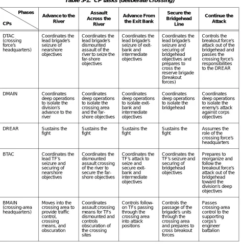
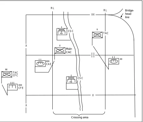
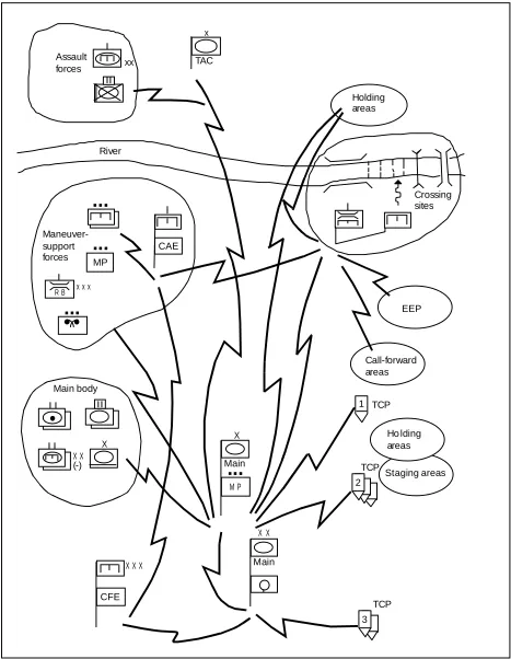
Division and brigade commanders are responsible for crossing their formations. They organize their staffs and subordinate commanders to help them control the cross-ing (see Table 3-1, page 3-2). Division and bri-gade headquarters operate from echeloned CPs. They are the tactical, main, and rear CPs and provide the staff and communica-tions support for planning and executing river crossings. The CPs may need some tem-porary augmentation or realignment of inter-nal staff elements for the crossing. Figures 3-1 and 3-2, pages 3-3 and 3-4, show the neces-sary control elements for deliberate and ret-rograde river-crossing operations. Each of the control elements is discussed below.
DIVISION HEADQUARTERS
The division tactical CP (DTAC) controls the lead brigades' (bridgehead force) attack across the river, since this is the division's close fight. It may reallocate crossing means
or movement routes to the river between brigades as the battle develops. The DTAC is the crossing-force headquarters.
The division main CP (DMAIN) prepares the river-crossing plan. It also directs the division's deep operations to isolate the bridgehead from enemy reinforcements and counterattacking formations. As a guide, the DMAIN displaces across the river after the division reserve. For division crossings, a traffic-control cell schedules, routes, and monitors traffic behind the lead brigades. The cell collocates with the DMAIN. The Assistant Chief of Staff, G4 (Logistics) (G4) provides the cell nucleus.
3-2 Command and Control
Crossing-Force Commander (CFC)
The division commander normally desig-nates an assistant division commander (ADC) as the CFC to take charge of control-ling the division crossing.
Crossing-Force Engineer (CFE)
A crossing division receives support from a CFE, who is normally the commander of an engineer group from the corps engineer bri-gade. He provides additional staff planners
Phases
CPs
Advance to the River
Assault Across the
River
Advance From the Exit Bank
Secure the Bridgehead Line Continue the Attack DTAC (crossing force’s headquarters) Coordinates the lead brigade’s seizure of nearshore objectives Coordinates the lead brigade’s dismounted assault of the river to seize the far-shore objectives
Coordinates the lead brigade’s seizure of exit-bank and intermediate objectives Coordinates the lead brigade’s seizure and securing of bridgehead objectives and prepares to cross the reserve brigade (breakout forces) Controls the breakout force’s attack out of the bridgehead and passes the crossing force’s responsibilities to the DREAR
DMAIN Coordinates
deep operations to isolate the division’s advance to the river
Coordinates deep operations to isolate the crossing area and the far-shore objectives
Coordinates deep operations to isolate exit-bank and intermediate objectives
Coordinates deep operations to isolate the bridgehead
Coordinates deep operations to isolate the enemy’s attack against corps objectives
DREAR Sustains the
fight Sustains the fight Sustains the fight Sustains the fight Assumes the role of the crossing force’s headquarters
BTAC Coordinates the
lead TF’s seizure and securing of nearshore objectives Coordinates the dismounted assault crossing of the river to secure the far-shore objectives
Coordinates the TF’s attack to seize and secure exit-bank and intermediate objectives Coordinates the TF’s seizure and securing of bridgehead objectives Prepares to reorganize and follow the breakout force’s attack out of the bridgehead toward the division’s deep objectives BMAIN (crossing-area headquarters)
Moves into the crossing area to provide traffic control, crossing means, and obscuration Coordinates assault crossing means for TFs dismounted and controls obscuration of the crossing sites Controls follow-on TFs passing through the crossing area into attack positions
Controls the passage of the brigade’s units through the crossing area and prepares to cross breakout forces
[image:24.612.56.528.113.590.2]Passes crossing-area control to the supporting corps’s engineer battalion
Command and Control 3-3
for the CFC and coordinates engineer sup-port to the crossing-area commanders (CACs).
BRIGADE HEADQUARTERS
Each brigade headquarters operates from echeloned CPs, the brigade tactical CP (BTAC), and the brigade main CP (BMAIN). The BTAC controls the advance to and the attack across the river. It dis-places across the river as soon as practical after the assault across the river to control
the fight for exit-bank, intermediate, and bridgehead objectives.
The BMAIN controls the crossing of the rest of the brigade. It prepares the brigade crossing plan and provides the staff nucleus to coordinate it. For brigade cross-ings, the Supply Officer (US Army) (S4), assisted by the supporting MP unit leader or engineers if available, organizes a small, temporary traffic-control cell collo-cated with the BMAIN.
CA C
CA E
x
RB
x
Ma i n
RB
xxx xx
R L
R L
B r i d g e h ea d l i ne
CF C xx
T A C
CF E xxx
Cr os s i ng a re a X
CS C
CS C
X
X
T A C XX
Figu re 3-1. Control elements for a deliberate crossing (brigade focus)
Crossing area
Bridge-head line
RB RB
[image:25.612.93.560.92.492.2]3-4 Command and Control
Crossing-Area Commander
Once the lead battalions assault across the river and secure the far-shore objective, the crossing area is activated. The CAC, normally the brigade's executive officer (XO), controls the movement of forces inside the crossing area. The BMAIN trols the maneuver-support force that con-sists of corps engineers, bridge companies, and MP and chemical units. This leaves the brigade commander free to direct key activities while an officer who is directly responsible to him runs the crossing. The CAC controls—
• The movement and positioning of all elements transiting or occupying posi-tions within the crossing area.
• Security elements at crossing sites. • Maneuver-support forces, such as
engi-neer, MP, and chemical units within the crossing area.
Crossing-Area Engineer (CAE)
Each forward brigade will normally be sup-ported by a direct-support engineer battalion from the corps. The engineer battalion com-mander is responsible to the CAC for the
CSC
CAC
CAE
CSC x
RB
TAC
x
Main
RB
xxx xx
RL RL Holding
line
CFC xx
TAC
CFE xxx
CB T
Crossing area XX
X
X
X
[image:26.612.57.524.91.474.2]Command and Control 3-5
engineer crossing means and sites. He informs the CAC of changes, due to technical difficulties or enemy action, that render a crossing means inoperable or reduce its capacity. He commands those engineers tasked to move the force across the river; they remain there as the attack proceeds beyond the exit-bank objectives. The division engineer battalion focuses on supporting the lead brigades at exit-bank, intermediate, and bridgehead objectives and is not normally involved in the river crossing.
Crossing-Site Commander (CSC)
Each crossing site has an engineer, either a company commander or a platoon leader, who is responsible for crossing the units sent to the site. Normally, the CSC is the company commander for the bridge unit
operating the site. He commands the engi-neers operating the crossing means and the engineer regulating points (ERPs) at the call-forward areas for that site. He main-tains the site and decides on the immediate action needed to remove broken-down or damaged vehicles that interfere with activi-ties at the site. He is responsible to the CAE and keeps him informed on the status of the site.
Unit-Movement-Control Officer
Each battalion and separate unit com-mander designates a movement-control officer, who coordinates the unit's move-ment according to the movemove-ment-control plan. He provides staff planners with detailed information on the unit's vehicle types and numbers.
COMMUNICATIONS
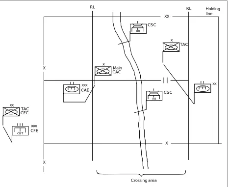
Figures 3-3 and 3-4, pages 3-6 and 3-7, depict the communications networks within a crossing area. In the hasty-crossing exam-ple, a brigade making a supporting attack conducts a crossing with its normal slice of combat-support forces plus a corps bridge company. More assets are available from the
division and corps in the deliberate-crossing example. Wire is the preferred means of communications in a river crossing when there is sufficient time to prepare it. The corps engineer battalion will establish wire communications with the nearshore cross-ing area accordcross-ing to the crosscross-ing plan.
CONTROL MEASURES
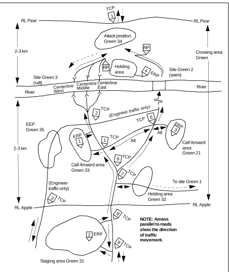
The commander uses control measures to delineate areas of responsibility for subor-dinates and to ease traffic control. Figure 3-5, page 3-8, illustrates the control mea-sures described below.
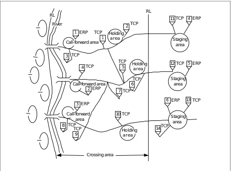
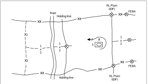
RELEASE LINES (RLS)
As used in river-crossing operations, RLs are used to delineate the crossing area. RLs are located on both the far and near shores and indicate a change in the headquarters that is controlling movement. RLs are nor-mally located within 3 to 4 kilometers of the river and on easily identifiable terrain features, if possible.
CROSSING AREAS
Crossing areas are controlled access areas that decrease congestion at the river. This permits swift movement of forces. Each lead brigade has a crossing area on both sides of the river that is defined by brigade bound-aries and RLs. Crossing areas normally extend 3 to 4 kilometers on each side of the river, depending on the terrain and the anticipated battle.
WAITING AREAS
3-6 Command and Control
1 TCP
2 TCP
TCP 3
AA
R B
E E P
Call-forward areas
M P
C F E
Crossing sites xx
x x x
X
X X
X X X X X X (-)
x
Main body Maneuver-support forces
Ho lding areas
Staging areas River
Holding areas Assault
forces
M P
Figu re 3-3. Communications for a deliberate crossing
EEP
Main
Main TAC
...
...
...
...
CAE [image:28.612.54.527.90.688.2]Command and Control 3-7
1 TCP
2 TCP
TCP 3
R B
E E P
Call-forward areas
M P
C F E
C A E
Crossing sites xx
x x x
X
X X
X X X X X X (-)
x
Main body Maneuver-support forces
Ho lding areas
Staging areas River
Holding areas Assault
forces
M P
Figu re 3-4. Communications for a hasty crossing
EEP TAC
Main
Main
...
...
...
CFE
...
MP [image:29.612.89.556.91.693.2]3-8 Command and Control
RP
4 RP
Staging area Green 31 RL Apple
(Engineer traffic only)
Call-forward area Green 33
Holding area Green 32
To site Green 1 Call-forward area Green 21
NOTE: Arrows parallel to roads show the direction of traffic
movement.
RL Pear
Attack position Green 34
Site Green 2 (swim) Holding
area Site Green 3
(raft)
River
EEP Green 35 River
2
RL Pear
RL Apple Alt
(Engineer
tr affi c only)
Alt
3 2-3 km
2-3 km
Crossing area Green
6
1 1
6
7
8
9 3
2
Centerline East
1
Figu re 3-5. Control measures TCP
TCP
ERP
ERP
TCP
TCP
TCP
TCP
TCP
TCP
TCP
ERP
ERP
Centerline Middle Centerline West
(Engineer
[image:30.612.58.522.85.636.2]Command and Control 3-9
vehicles, troops, and equipment while wait-ing to resume movement or to make final crossing preparations:
• Staging areas. • Call-forward areas. • Holding areas. • Attack positions. • AAs.
Staging areas
Staging areas are battalion-size waiting areas outside the crossing area where forces wait to enter the crossing area. The brigade traffic-control cell handles units’ movement into staging areas. The CAC controls move-ment from the staging areas into the cross-ing areas. MP operate traffic-control posts (TCPs) at staging areas according to the crossing and traffic-circulation plans. They emplace temporary signs along the route from the staging area through the crossing area to guide convoys. Units make crossing preparations and receive briefings on vehi-cle speed and spacing in the staging areas. Staging areas—
• Are located to support the crossing con-cept.
• Are far enough back to permit the rerouting of the battalion along other roads or to alternate crossing sites. • Are easily accessible from major routes. • Have sufficient area for dispersing a
battalion-size unit. • Provide concealment.
Call-Forward Areas
Call-forward areas are company-size wait-ing areas located within the crosswait-ing area. Engineers use them to organize units into raft loads, or crews use them to make final vehicle swimming preparations. The CAC controls movement from the staging area to the call-forward area. The CSC directs
movement from the call-forward area to the crossing site and on to the far-shore attack position. As a minimum, each CSC operates his own call-forward area. Call-forward areas—
• Are located to support the crossing plan. • Are company size within the crossing
area.
• Are easily accessible from routes.
• Are planned with a minimum of one per crossing site.
• Have ERPs collocated with them.
• Are used to organize units into raft loads. • Are the final preparation areas before
going to the crossing site.
• Are normally operated by engineers.
Holding Areas
Holding areas are waiting areas that forces use during traffic interruptions. Units move into these areas when directed by TCP per-sonnel and disperse rather than stay on the roads. Holding areas are battalion size out-side of the crossing area and company size within it. Far-shore holding areas are used to organize return traffic. MP and engineers, if available, operate holding areas according to the crossing and traffic-circulation plans. Established as needed on both sides of the river, holding areas—
• Are used as call-forward areas for return traffic from the far shore.
• Are located to support the crossing plan. • Are easily accessible from routes.
• Have sufficient area for dispersion. • Provide cover and concealment. • Are defensible.
3-10 Command and Control Attack Positions
Attack positions are the last positions occu-pied or passed through by the assault eche-lon or attacking force before crossing the line of departure. Within the bridgehead, the attack position is the last position before leaving the crossing area or bridge-head line.
Assembly Areas
AAs are areas in which a force prepares or regroups for further action.
ENGINEER EQUIPMENT PARKS (EEPS)
EEPs are areas located a convenient distance from bridging and rafting sites for assem-bling, preparing, and storing bridge equip-ment and material. They are at least 1 kilometer from the river and hold spare equipment and empty bridge trucks that are not required at the crossing sites. EEPs should be located where they do not interfere with the traffic to the crossing sites and where equipment can be concealed and dis-persed. Ideally, routes leading from EEPs to the crossing sites are not the same routes used by units crossing the river.
TRAFFIC-CONTROL POSTS
In river crossings, TCP personnel assist the crossing-area headquarters in traffic control by reporting and regulating the
movement of units and convoys. TCP per-sonnel relay messages between the cross-ing-area headquarters and moving units. The provost marshal identifies locations that need or require TCPs. MP or engi-neers, if available, operate TCPs on both banks of the river to control traffic moving toward or away from it. TCPs are addition-ally operated at major or critical crossroads and road junctions, staging areas, holding areas, and ERPs.
ENGINEER REGULATING POINTS
ERPs are technical checkpoints which are used to ensure that vehicles do not exceed the capacity of the crossing means. They help maintain traffic flow. Vehicles which will not be allowed to cross are removed so that they do not cause a traffic backup at the actual crossing site. Engineers man the ERPs and report to the CSC. TCPs are collo-cated with the ERPs to ensure that all vehi-cles clear the call-forward areas. An additional duty of ERP personnel is to give the drivers final instructions on site-specific procedures and other information such as speed and vehicle intervals. As a minimum, each crossing site requires an ERP at its own call-forward area. If sufficient engineer assets are available, ERPs may be estab-lished at far-shore holding areas to regulate rearward traffic.
CROSSING PLAN
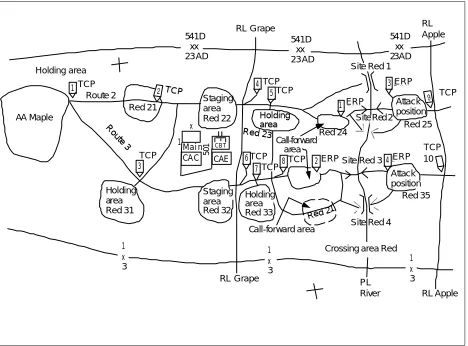
The crossing plan is integrated throughout the division's and brigade's operation orders (OPORDs) and is as detailed as time permits. The crossing annex to the OPORD contains much but not all of the plan. It has the crossing overlay and the crossing syn-chronization matrix.
The crossing overlay shows the crossing areas, the crossing sites, the routes leading up to them from waiting areas, and all the control measures necessary for the crossing
(see Figure 3-6). The crossing synchroniza-tion matrix is a tool to adjust the crossing plan as the battle develops. It shows ing units in relation to their planned cross-ing times and locations. See Appendix B for an example matrix.
Command and Control 3-11 1 3 4 2 CB T CA C x Mai n CAE 1 50 1 Holding area Red 33 1 x 3 1 x 3 Holding area Red 31 AA Maple Holding area Route 2
Red 21 Stagingarea
Red 22
Staging area Red 32
RL Grape
Call-forward area Call-forward area
Site Red 4 Red 24
PL
River RL Apple
Red 35 Site Red 3
RL Apple
Site Red 1
Attack position
Red 21
541D xx 23 AD Attack position Red 25 1 x 3 541D xx 23 AD 541D xx 23AD
Site Red 2 E R P
E R P 5
6
7 8
3 1
RL Grape
E R P
Crossing area Red 4
CROSSING CONTROL
Commanders use control measures to oper-ate, delegate authority, and lead from any critical point during the river-crossing oper-ation while synchronizing other critical actions throughout their area of operations.
ASSAULT ACROSS THE RIVER
Battalion task forces (TFs) conducting the assault across the river move to it under the direct control of their brigade commanders. The assault TFs using rubber boats 15 (RB15s) follow the procedures in Chapter 8. The brigade commander keeps the remain-der of the brigade back from the river to avoid congestion. Elements not engaged in
security or supporting the crossing occupy AAs and prepare for movement across the river.
CROSSING-AREA OPERATIONS
[image:33.612.90.558.92.438.2]After the assault across the river, the brigade has an initial position on the far shore and is no longer fighting to seize the exit bank. The brigade needs its follow-on forces across as quickly as possible. The battalions can now cross without engaging in combat at the river. The brigade commander activates the crossing area to move forces rapidly and effi-ciently. The urgent need to get tanks across the river means the rafting stage often
Figure 3-6. Crossing overlay
3-12 Command and Control
begins before terrain on the far shore is secure to the planned RL. Therefore, the crossing area is initially limited to the near shore. The first fighting vehicles swimming or rafting across under this circumstance have limited space to regroup before commit-ment to the fight.
As the initial battalions cross, they gain ter-rain to the necessary depth, and as control elements cross to the far shore, the brigade commander extends the crossing area out to the planned RL. Thereafter, units move com-pletely through the crossing area under the CAC's control and exit it in a tactical move. When rafting, the crossing flow for the fol-low-on units is generally from a staging area, through the call-forward area and crossing site into an attack position, and then on to a subsequent objective. While bridging, the flow is from a staging area, through the crossing site, and then out of the crossing area.
Figure 3-7 illustrates the traffic flow for a fol-low-on battalion TF during the rafting. This procedure avoids congestion close to the cross-ing site and helps maintain unit integrity while the battalion rafts. The battalion occu-pies staging area Green 31 and organizes an internal unit crossing order based on its mis-sion on the far shore. When concurrently swimming and rafting vehicles of the same battalion, the swimming vehicles form up sep-arate from nonswimming vehicles for move-ment to the crossing sites and reform into a tactical formation at the far-shore attack posi-tion. ERP personnel at the call-forward area check to determine the correct load classifica-tion and proper loading sequence for each vehicle. When instructed by the CAC, the battalion sends one company at a time (or the equivalent) from the staging area. TCP per-sonnel guide the company's movement en route to a call-forward area where it comes under the movement control of the CSC.
In the call-forward area at site Green 33, ERP personnel organize individual vehicles into raft loads. They guide the raft loads down to the raft centerlines as the CSC directs. In the call-forward area at site Green 21, vehicle crews make the final vehicle swimming preparations. ERP personnel send the vehicles down to the swimming site when directed by the CSC.
Vehicles remain under the control of the CSC until they are on the far shore. There they proceed to attack position 6, where they regroup as a company/team. When ready, the TF commander, under the tacti-cal control of the brigade commander, con-trols the movement of the vehicles.
During bridging operations, the CAC nor-mally directs the follow-on battalions to move in company serials from the staging area. Each serial moves down to the bridge site, crosses the river, and continues on to the attack position. The CAC directs an interval between serials that keeps contin-uous traffic across the bridge without gaps or traffic jams. A call-forward area remains established in the event that the bridge becomes damaged and units must be held until raft operations resume.
Units in the support-by-fire position on the near shore are already inside the cross-ing area when the crosscross-ing operation starts. They remain in this position until the CAC directs them to cross the river, and then they move directly to previously selected call-forward areas or start points (SPs) by company or platoon.
TRANSFER OF SUPPORT FORCES TO DIVISION
Command and Control 3-13 Figure 3-7. Follow-on-TF crossing during a rafting phase
TCP
RP
Staging area Green 31 RL Apple
Call-forward area Green 33
Holding area Green 32
Call-forward area Green 21
NOTE: Arrows parallel to roads show the direction of traffic movement.
RL Pear
Attack position 6
Site Green 2 (swim) Holding
area
Site Green 3 (raft)
River River
RL Pear
RL Apple 4
3
1 1
3 2
6
ERP 4
5
2 ERP
ERP
TCP TCP
TCP TCP TCP
3-14 Command and Control
and traffic-scheduling problem. The division headquarters moves the RL at the rear of the bridgehead force to the far shore. The crossing areas come under direct division control. As the ADC directs, the brigade commander turns over his crossing area to
another officer, normally the CAE, who becomes responsible for the crossing area. The CAE then reports through the CFE to the ADC at the DREAR. The CAE's unit headquarters becomes the crossing-area headquarters.
MOVEMENT CONTROL
Movement control is vital to efficiently move units and material up to the crossing area in the sequence needed by the commander. The