Abstract
Aerial photos in Alberta are generally acquired according to topographic mapping and forestry specifications. The parameters for interpreting rangeland vegetation, such as sil- ver sagebrush (Artemisia cana-Pursch), need to be explored and condensed into an operational specification. Five aerial films and 3 solar angles were evaluated by 7 photo inter- preters to determine the optimal conditions for interpreting silver sagebrush at a scale of 1:20,000. Interpreter accuracy and preference are determined for the 2 experimental condi- tions as to determine operational specifications. Kodak Panatomic-X 2412 achieved the highest interpretation accu- racies for silver sagebrush cover detection and plant density estimation (91.0% and 94.4% respectively), while Kodak Aerochrome Infrared 2443 and Agfa Avicolor H100 per- formed best for estimating plant vigor (92.7% and 93.7%
respectively). Photo interpreters also chose Kodak Panatomic-X 2412 as the preferred film for interpreting sil- ver sagebrush (7.7 on a scale of 10). Positive correlations were obtained between combinations of interpretation accuracy, interpreter film preference and photographic density range measurements, indicating the trends for higher accuracy and preference are associated with higher density ranges. Solar angles of 20°, 37° and 54° were evaluated by photo inter- preters with significant preference shown for 20˚.
Recommendations for modifying Alberta’s air photo opera- tional specifications to include high resolution (Kodak Panatomic-X) imagery and decreasing the acceptable lower boundary for the operational solar angle from 30 to 20° for interpreting silver sagebrush at the 1:20 000 scale are pro- posed.
Key Words: Aerial photography, spectral sensitivity, film res- olution, air photo specifications, air photo, interpretation
Silver sagebrush (Artemisia cana-Pursch) has a ubiqui- tous presence on the Great Plains of North America. Its occurrence has led to strategies ranging from eradication to conservation and protection. It is a common native shrub, characteristic of the dry mixed grass natural region of
Alberta (Achuff 1994). It also defines the habitat condi- tions for a range of wildlife species such as pronghorn antelope (Antilocarpa americana) and sage grouse (Centrocercus urophasianus) (Mitchell and Smoliak 1971, Wallestad 1976, Glaholt 1984, Kerley and Anderson 1995).
Silver sagebrush is a short shrub with typical heights around 0.25 to 0.75 m, but heights of 1.0 to 1.5 m are not
J. Range Manage.
52:32–38 January 1999
Aerial films and solar angles: Influences on silver sagebrush inventory
LIVIO FENT
Author is a resource information project coordinator and photographic scientist in the Resource Information Unit, Environmental Service-Prairie region, Alberta Environmental Protection, YPM Place 3rdfloor, 530 8thstreet South, Lethbridge, Alberta, Canada. T1J 2J8.
Resumen
Las fotografís aéreas en Alberta son generalmente adquiri- das de acuerdo al mapeo topográfico y especificaciones fore- stales. Los parametros para interpretar la vegetación de pas- tizal, tal como “silver sagebrush” (Artemisia cana - Pursch), necesitan ser explorados y condensados en una especificación operacional. 7 fotointerpretadores evaluaron 5 tipos de pelíu- la area y 3 ángulos solares para determinar las condiciones óptimas para interpretar el “silver sagebrush” a una escala de 1:20,000. La exactitud y preferencia del interpretador son determinadas para las dos condiciones experimentales, así como para determinar la especificaciones operacionales. La película Kodak Panatomic-X 2412 logró la mayor exactitud de interpretación para la detección de la cobertura y densi- dad de plantas de “silver sagebrush” (91.0% y 94.4% respec- tivamente), en tanto Kodak Aerochrome Infrared 2443 y Agfa Avicolor H100 fueron mejores para estimar el vigor de la planta (97.2% y 93.7% respectivamente). Los fotointerpre- tadores también escogieron la película Kodak Panatomic- X 241 como la mejor para interpretar el “silver sagebrush” (7.7 en base a una escala de 10). Se obtuvieron correlaciones posi- tivas entre combinaciones de exactitud de intrepretación , perferencia del tipo de película del fotointerpretador y las medidas del rango de densidad fortográfica, indicando las tendencias que una mayor exactitud y preferencia estan aso- ciadas con los rangos de densidad mayores. Los ángulos solares de 20°, 37° y 54° fueron evaluados por los fotointer- pretadores los cuales tuvieron una preferencia por el ángulo de 20°. Se proponen recomendaciones para modificar las especificaciones operacionales de la fotografía area de Alberta para incluir imagnes de alta resolución (Kodak Panatomic-X) y disminuir de 30° a 20° el límite inferior operacional del ángulo solar para interpretar “silver sage- brush” en la escala de 1:20,000. mentaron en promedio 0.5 y 1.2°C respectivamente.
Author would like to thank Dr. R.J.Hall for preliminary review of the manuscript and Mr. L. Fitch for providing general guidance and encouragement for this project.
Manuscipt accepted 19 Apr. 1998.
uncommon in ideal soil moisture con- ditions. It tends to grow in mesic sites where it is often found in fairly dense distributions. The presence and abun- dance of silver sagebrush can reduce the production of associated grasses and forbes (White and Currie 1983, 1984). The shrub is also commonly found in low lying level, poorly drained clay soils and saline areas (Smoliak et al. 1981). In Alberta, it is frequently associated with the Orion (ORN) soil series (Contract Pedology- Lethbridge, personal communication, 1997), and is also the dominant species of sagebrush flats (Wershler and Wallis 1986). Silver sagebrush can usually be identified by its distinc- tive light blue-green and silvery hue that contrasts sharply among the greener or yellow-brown grasses and shrubs (depending on the moisture sit- uation) on the prairie landscape (Wilkinson 1990).
The interest in the plant, whether for wildlife habitat preservation or for agricultural efficiency, has led investi- gators to explore various means for identifying and mapping its distribu- tion on rangelands. Aerial photographs remain the most used and the highest resolution product able to capture the spatial and textural characteristics of the scene (Tueller 1989, Driscoll 1992). Although aerial photographs remain the traditional remote sensing tool, the technology associated with it has not been stagnant. Improvements in films, cameras, and lens have been particularly vigorous over the past 10 years (Fent 1990, Bahnmüller 1992, Fent and Brouwer 1993, Mussio and Light 1995, Light 1996).
The application of these advance- ments and innovations in aerial pho- tography have been investigated to some degree in forestry (Hall and Fent 1991, Fent et al. 1995), however, spe- cific details in optimizing aerial pho- tographic product performance for identifying silver sagebrush (and for other rangeland applications) have been limited to large scale photo- graphic studies (Nesby 1986, Werth and Work 1991). In addition to the spectral influences of aerial films in detecting silver sagebrush, other pho- tographic variables will also impact
the shrub’s photographic recording identity. Image contrast, varied either photographically or by solar angle, has a major effect upon the quality of photo interpretation (Welch and Halliday 1975). Furthermore, human preference for specific film or contrast may also be an influencing factor in air photo interpretation (Hall and Fent 1991).
The objective of this study was to investigate whether 2 photographic variables, film type and contrast change associated with different solar angles, are factors in detecting and classifying silver sagebrush distribu- tions. The study objective was addressed by the following 3 ques- tions: is there a film type that leads to greater accuracies in interpreting sil- ver sagebrush; is there a film type that is more preferred by interpreters for interpreting silver sagebrush, and; is solar angle a factor for air photo inter- pretation of silver sagebrush?
Study Area
The study area is located in Township 1 Range 2 west of 4 meridi- an in the southeast corner of the province of Alberta and adjacent to Montana (National Topographic System map sheets 72 E/1). It is locat- ed within the Dry Mixed Grass Ecoregion (Strong and Leggat 1981).
A north-south 12 km flight line was flown along Sage Creek to capture a wide diversity in silver sagebrush dis- tribution, density, and vigor.
Materials and Methods
Aerial Photography
The 5 aerial films1 selected are described in Table 1 (Agfa-Gevaert 1990a, 1990b; Eastman Kodak 1992).
The Kodak Aerographic Infrared 2424 (BWIR) is a near-infrared sensitive aerial film with a spectral sensitivity extending to approximately 900 nm.
Agfa Aviphot Pan 50 (A50) and Kodak Panatomic 2412 (PANX) are
classed as extended red sensitivity films with spectral sensitivities extending to approximately 750 and 720 nm, respectively (Table 1). The Agfa Avicolor H100 (H100) is a true color film manufactured by Agfa while the Kodak Aerochrome Infrared 2443 (CIR) is a standard false color infrared film manufactured by Kodak.
Table 1 also outlines the spatial reso- lution of the aerial films; PANX and A50 are regarded as high resolution films while the other emulsions are general purpose films.
The aerial photography was acquired at 2 separate times. The first acquisition occurred on 14 July 1996 with all films flown at a scale of 1:20 000. The 5 films were flown and exposed with a forward motion com- pensation (FMC) equipped metric aer- ial camera (Zeiss Jena) and with mini- mal rate change in the solar angle (54˚
± 1˚). Processing was conducted with the same processor (Kodak Versamat II) and chemicals (Kodak 885) for the black-and-white films. The color films were processed in their own respective processing environments (EA-5 for CIR and C-41 in high color saturation mode for H100). The contrast of the black-and-white films was further con- trolled sensitometrically by processing all the films to an average gradient of 1.402 and printing the negatives on grade 3 paper. The CIR film was sen- sitometrically evaluated to determine its IR balance value (Fleming 1979) and exposed such that an IR balance of 28 was achieved to compensate for altitude and inherent infrared film sen- sitivity. All films except the H100 were exposed with a minus blue (500 nm) cutoff filter to reduce haze effects, the H100 was exposed with a 420 nm haze compensating filter. These con- siderations served to reduce the effect of image motion, variable contrast, and film processing that would otherwise mask the differences among films and affect interpretation accuracies.
1The mention of trade names does not imply endorsement by the author.
2Average gradient (G) defines the ratio of the brightness range of objects photographed on the ground and the photographic density measured on the negative (International Standards Organization 7249, 1986). A brightness range to density ratio of 1:1 equals an average gradient of 1.0. An average gradi- ent of 1.4, therefore, indicates that the photographic contrast (or density range) was enhanced by 40% rel- ative to the ground contrast.
The second air photo acquisition phase occurred on 8 July 1997 using the same camera and scale. The best performing film from the phase 1 analysis (PANX) was flown at 3 dis- tinct solar angle conditions, 20˚ ± 0.5˚, 37˚ ± 0.5˚, and 54˚ ± 0.5˚, providing 3 unique solar angle contrast conditions to evaluate. The average gradient (1.40) and paper grade (3) were controlled to isolate the contrast changes due to solar angle. The 2 phase experimental design was deemed necessary to adequately control the continuously changing envi- ronmental light conditions.
Interpretation Procedure
Thirty-two polygons were selective- ly chosen along the flight path and among the different films for the inter- pretation procedure. The polygons varied in silver sagebrush coverage, density and vigor. This ensured each film type was represented by different polygons, and prevented photo inter- preters interpreting the same stand more than once. Seven interpreters from various government and private agencies familiar with rangeland photo interpretation participated in the first phase of the study. The inter- preters were asked to identify silver sagebrush for each of the polygons outlined on the aerial photographs by primarily noting the percentage of sagebrush covering the polygon and
also stratifying the cover by density (in stems/ha) and plant vigor. Each of these 3 attributes were classed in 6 percentage intervals; the interpreter was asked to choose which of the 6 classes best represented the attribute in question (Table 2). The interpreters were provided with a photo interpreta- tion key of silver sagebrush at a 1:20 000 scale as means to train themselves in recognizing the various silver sage- brush attributes. The ground reference information was obtained from field surveys of each of the 32 chosen poly- gons (used to determine vigor quali- ties) and from 35 mm reconnaissance photographs taken from a helicopter at a scale of 1:500 (use to determine den- sity and ground cover percentage).
The ground reference information was also categorized using classes described in Table 2.
Data compilation and statistical analysis
Interpretation accuracy was deter- mined by calculating the difference between the interpreters’ interpreta- tion class of an attribute and the ground reference class. The difference indicated the number of classes the interpreter deviated from the ground truth (Fent et al. 1995). Since each of these classes were approximately 16.7%, an interpretation accuracy value (Ai) could be calculated by the
following formula:
Ai= 100 - ((|Ii- Gi|) 16.7) where
Ii = Interpreted class value Gi = Ground reference class value
The 7 photo interpreters, interpret- ing 3 cover attributes, for 32 polygons created a database of 672 accuracy values which were then stratified by film type. A one-way analysis of vari- ance (ANOVA) was conducted on the balanced data set (Table 3) and the Tukey multiple means comparison (SAS Institute 1985, Neter et al. 1990) was employed to determine if there were significant differences among the films (Table 4).
Interpreters were also asked to rank each of the film combinations for pref- erence on a scale of 1 to 10 with the high score indicating high preference.
The preference values were averaged and ranked, and associated to film interpretation accuracy and density range rankings. The ranks were ana- lyzed using Spearman’s Rank Correlation Coefficient (rs) (Mosteller and Rourke 1973).The phase 2 data compilation required interpreters to rank the PANX flown at the 3 differ- ent solar angles. Five additional inter- preters (total 13) participated in this process and the results were compared and analyzed for statistical signifi- cance using the Friedman Statistic (χ2r) (Mosteller and Rourke 1973) .
Results and Discussions
Interpretation Accuracy
The first question of this study was to determine which of the 5 films per- formed best when silver sagebrush cover, density, and vigor were inter- preted. PANX was the highest per- forming film for interpreting silver sagebrush ground cover and density (Table 4), while the color films per- formed best when interpreting vigor (Table 4). PANX is distinguished from the other films by its superior resolu- tion and apparently aids the interpreter in detecting and assessing the distribu- tion of silver sagebrush. The relatively small scale (1:20 000) of the interpre-
Table 1. Aerial films investigated and some defining characteristics.
Film Spectral
Films Type Abbreviation Resolution sensitivity
(lp/mm) (nm) Kodak Infrared Aerographic 2424 black and white BWIR 50 900
Agfa Aviphot Pan 50 black and white A50 81 750
Kodak Panatomic Aerographic II 2412 black and white PANX 125 720
Agfa Avicolor H 100 color H100 40 670
Kodak Aerochrome Infrared 2443 color CIR 32 900
Table 2. Silver sagebrush attributes that interpreters were requested for each of the 32 polygons.
Coverage Class Density Classes Vigor Classes
(stems/hectare)
0 = no sagebrush 0 = no sagebrush 0 = no sagebrush
1 = 1–20% 1 = ≤500 1 = dead
2 = 21–40% 2 = 501–1000 2 = poor
3 = 41–60% 3 = 1001–2000 3 = average
4 = 61–80% 4 = 2001–4000 4 = good
5 = 81–100% 5 = ≥4001 5 = excellent
tation images may also favor a high resolving film such as PANX in detecting a small shrub such as silver sagebrush. The increase in interpreta- tion accuracy associated with PANX is also noted in applications associated with forestry and photogrammetry (Becker 1988, Fent et al. 1995, Hall and Fent 1996). The higher results produced by CIR and H100 for inter- preting plant vigor (Table 4) were not
unexpected given the phenological properties of the plant in mid-summer.
The vigor attribute is highly depen- dent on the plant’s leaf reflective prop- erties which are at optimum condition during the growing season (White and Currie 1984). Films that add a color dimension, such as the CIR and H100 have an inherent advantage over the black-and-white films in portraying hue differences. Moreover, a film such as CIR that has both color and infrared sensitivity, will have an added advan- tage over other films in detecting plant health attributes. The overall results suggest that PANX is the best film for assessing quantity attributes while the
color films are better tools for assess- ing quality attributes.
Interpreter Film Preference The second question in this study was to determine whether interpreter preference differed among the film types. The most preferred film was PANX, with the A50 and CIR also showing relatively high preference as noted by the 95% confidence interval bars in Figure 1. The least preferred films were the H100 and the BWIR.
These results suggest that the superior resolution characteristics of PANX and A50 (125 and 80 lp/mm, respec- tively) are an important factor in the interpreter ’s assessment of ‘good’
quality or ease of interpreting sage- brush. In addition, slower speed and sharper films tend to have more con- trast giving a further impression of sharpness and increased subjective preference (Pfenninger 1984).
Although the resolution quality of CIR is relatively low, this film’s higher ranking was most likely associated with its infrared sensing and color ren- dition qualities. It should be noted, however, that this film also showed the greatest ranking variation as indi- cated by the 95% confidence interval bars in Figure 1. The H100, although a color film, may be disadvantaged at a scale of 1:20 000 because of poor haze penetration abilities, while other films fare better in this regard due to either haze filtration or infrared sensitive properties. Haze will reduce contrast, detail, and apparent sharpness in aerial photographs leading to a lower prefer- ence rating.
BWIR’s poor ranking may be asso- ciated with the phenology of silver sagebrush plant relative to the general reflective character of its immediate environment. The reflective character- istics of the light green-silvery hues of the leaves are an atypical feature of this plant and show a gradual and
quasi-linear increase from the blue to the infrared portion of the electromag- netic spectrum (Tueller 1989). Most vegetation shows a defined ‘red edge’
where the infrared reflective portion is abruptly higher than the visible reflec- tive component (Brandes 1994). It is this contrast between the visible and the infrared reflective character of plants that aids photo interpreters in identifying vegetative characteristics.
In silver sagebrush, this marked differ- ence is subdued and further reduced because the near infrared reflective character of the surrounding grasses is relatively low, especially when they are in the maturity stage or under water stress. The lack of spectral con- trast among ground vegetation, the rel- atively lower resolution of the film, and the lack of color (CIR’s advan- tage) all may be factors associated with BWIR’s perceived non-utility in silver sagebrush interpretation.
Accuracy-Preference-Density Range
The photographic density range of an image is a good indicator of the image’s contrast. The density range of the experimental film images will vary because image contrast in this experi- ment is being determined exclusively by the films’ spectral attributes. These contrast differences provide further evidence for deciphering the film accuracy and preference results.
Spearman’s Rank correlation results (Table 5) indicate a positive (rs= 0.90) and significant (P< 0.05) trend between density range and preference.
Density range and accuracy correla- tions were also positive (rs = 0.80) but insignificant (P > 0.10). Positive and significant correlations were, however, noted between interpreter preference and accuracy (rs = 0.90, P < 0.05).
These correlated trends suggest that interpreters are noting contrast as an interpretation aid influencing both interpreter preference and accuracy.
Contrast variations in this experiment were attributable to the spectral differ- ences between films; however, defin- ing an ideal contrast requires that average gradient and paper grade vari- ables also be investigated and related to the density range parameter.
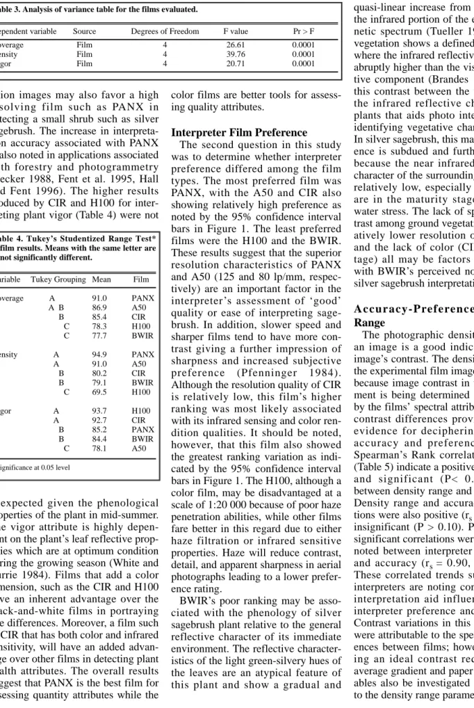
Table 3. Analysis of variance table for the films evaluated.
Dependent variable Source Degrees of Freedom F value Pr > F
Coverage Film 4 26.61 0.0001
Density Film 4 39.76 0.0001
Vigor Film 4 20.71 0.0001
Table 4. Tukey’s Studentized Range Test*
film results. Means with the same letter are not significantly different.
Variable Tukey Grouping Mean Film
Coverage A 91.0 PANX
A B 86.9 A50
B 85.4 CIR
C 78.3 H100
C 77.7 BWIR
Density A 94.9 PANX
A 91.0 A50
B 80.2 CIR
B 79.1 BWIR
C 69.5 H100
Vigor A 93.7 H100
A 92.7 CIR
B 85.2 PANX
B 84.4 BWIR
C 78.1 A50
*Significance at 0.05 level
Solar Angle Contrast
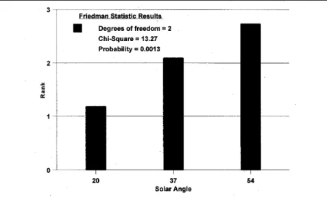
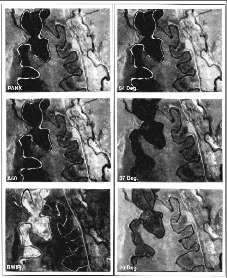
The third question in this study was to investigate whether solar angle was a factor in the interpretation of silver sagebrush. Interpreter assessments showed a highly significant preference (P<0.01) for the images flown at a solar angle of 20˚±0.5˚ followed by the 37˚±0.5˚ and the 54˚±0.5˚images (Fig. 2). The enhanced contrast result- ing from longer shadows accentuates the vegetative and topographic ground pattern and allows the interpreter a better textural context for identifying silver sagebrush distribution. The shadow information also provides the interpreter with cues on appraising shrub height that would not be pho- togrammetrically possible given the minimal image displacement at the scale of the photo. The solar angle photo samples in Figure 3 depict this effect.The relatively low solar angle preferred by the interpreters, however, should be considered with some degree of caution. The topographic character of the landscape may be a factor in obscuring land detail where slopes greater than 20˚ are encoun- tered and the practicalities of flying with such a restricted solar angle may not be economically feasible. In essence, the decision to fly at lower solar angles should acknowledge the enhancements of textural and topo- graphic detail, but be wary of both the length of time required to fly the pro- ject and the terrain morphology.
Conclusion
The results of this study indicate that, at a scale of 1:20 000, PANX film (G=1.40) flown at relatively low sun angles provides the best results for interpreting silver sagebrush cover and density, with color films showing an advantage for interpreting plant vigor.
These findings suggest that a modifi- cation in air photo specifications for rangeland applications, silver sage- brush inventory in particular, may be warranted in Alberta.
The recommended use of PANX, implies that higher spatial resolution and contrast, rather than spectral sen- sitivity, is the key factor in detecting
Fig. 1. Mean interpreter preference ranks with 95% confidence intervals the higher resolv- ing films (PANX, A50) is indicated. CIR also shows relatively high preference but with more variation (less agreement among interpreters).
Table 5. Values for interpretation accuracy1, preference and density range2are ranked and ana- lyzed3for each film type.
Film Preference Interpretation accuracy Density range
Value Rank Value Rank Value Rank
BWIR 3.2 4 78.2 5 0.30 4
A50 7.0 2 81.1 3 0.54 3
PANX 7.7 1 90.4 1 0.76 1
H100 2.6 5 80.5 4 0.18 5
CIR 6.8 3 86.7 2 0.68 2
1Mean of the cover, density, and vigor accuracy values for each film
2Status M densiometry, visual filtration (1mm aperature)
3Spearman’s Correlation Coefficients:
Preference X Interp. accuracy rs=0.90 Pr=0.0374 Preference X Density range rs=0.90 Pr=0.0374 Interp accurancy X Density range rs=0.80 Pr=0.1041
Fig. 2. Mean interpreter preference ranks of the PANX flown at the 3 different solar angles.
The highly significant results (P < 0.01) indicate that interpreter preference increases as the solar angle decreases.
Fig. 3. A part of the study area as depicted by the 3 black-and-white films (left) and the 3 solar angle conditions using PANX (right).
Significant occurrences of silver sagebrush are located along the dry creek bed along the center of the photos. The 20° solar angle condition is the only instance where the textural detail is sufficiently enhanced to show individual stands of silver sagebrush.
silver sagebrush at a scale of 1:20 000.
Because this film is relatively low in sensitivity (40 ISO A), image motion effects must be addressed.
FMC cameras, thus, become essen- tial in exploiting the film’s resolution characteristics.
The interpreter preference for a lower solar angle needs to be imple- mented carefully. Adopting a lower solar angle would entail a change from the minimum current value in Alberta of 30˚ to about 20˚. Values lower than 20˚ would be impractical because of extreme shadows and low lighting conditions (especially when PANX is considered). The maximum value is defined only in that it should be below the second most preferred experimen- tal level of 37˚±0.5˚. A working range of 20˚ to 35˚, with the understanding that the higher end values will dimin- ish interpretability and lower end val- ues may obscure some slope informa- tion is suggested. The operational range cannot be too narrow otherwise flying time is compromised.
The results and recommendations proposed suggest a modification in acquiring aerial photography for rangeland applications, or at least a consideration of the factors that will aid vegetation interpretation in prairie environments when relatively small scales are used. Optimizing these pho- tographic factors should lead to more accurate initial stratifications of vege- tation and more efficient methods for inventories of silver sagebrush.
Literature Cited
Achuff, P.L. 1994. Natural regions, subre- gions, and natural history themes of Alberta. Alberta Environmental Protection. Edmonton, AB.
Agfa-Gevaert N.V. 1990a. Aviphot Pan 50 PE1 technical information. Agfa-Gevaert N.V. Mortsel, Belgium 789(Li).
Agfa-Gevaert N.V. 1990b. Aviphot Color H 100 PE1 technical information. Agfa- Gevaert N.V. Mortsel, Belgium 6030/Li.
Bahnmüller, W. 1992. Aviphot black and white films - sensitization and modulation transfer function. In: Proc. of International Society for Photogrammetry and Remote Sensing, XVII Congress, Vol. XXIX, Part B1, Commission I, Washington, D.C.Becker, R. 1988. Very high resolution aerial films. Photogrammetria, 42:283–302
Brandes, J. 1994. Black and white aerial film characteristics: a primer. Earth Observation Magazine 3(10):49–50.
Driscoll, R.S. 1992. Remote sensing- an invaluable ally for assessing and managing renewable natural resources. GIS World 5(4):66-69.Eastman Kodak. 1992. Kodak data for aerial photography. Publ. No. AS- 29. Rochester, N.Y.
Fent, L. 1990. A more discriminating use of aerial photographic emulsions and pro- cessing techniques. In: Proc. Symp. on Global and Environ. Monitoring, Techniques and Impacts. ISPRS Comm.
VII. Victoria, BC.
Fent, L. and J.M. Brouwer. 1993.
Evaluation of four color negative aerial films. State-of-the-Art Mapping. In: Bill P. Clark, Andy Douglas, Brian L. Foley, Brian Huberty, LeLand D. Whitmill, Ed(s). Proc. SPIE 1943:164–171.
Fent L., R. J. Hall, and R. K. Nesby. 1995.
Aerial films for forest inventory: optimiz- ing film parameters. Photogramm. Eng.
Remote Sensing 61:281–289.
Fleming, J.F. 1979. Standardization tech- niques for aerial color infrared film.
Interdepartmental Committee on Air Surveys. Ottawa, Canada.
Glaholt, R.D. 1984. Availability of critical pronghorn antelope habitat in southern Alberta and its relation to land use. M.Sc.
Thesis Univ. Calgary, Calgary, AB.
Hall, R.J. and L. Fent. 1991. Relating forestry interpreter preference to sensito- metric parameters of black and white and normal color aerial films. ISPRS J.
Photogramm. Remote Sensing 46:328–345 Hall, R.J. and L. Fent. 1996. Influence of aerial film spectral sensitivity and texture on interpreting images of forest species composition. Can. J. Remote Sensing 22:350–359.
International Standards Organization 7829. 1986. Photography–black and white aerial camera films determination of ISO and average gradient. International Organization for Standardization. Ref. No.
ISO 7829–1986(E).
Kerley L.L. and S.H. Anderson. 1995.
Songbird responses to sagebrush removal in a high elevation sagebrush steppe ecosystem. Prairie Naturalist. 27:129–146 Light, D.L. 1996. Film cameras or digital
sensors? The challenge ahead for aerial imaging. Photogramm. Eng. Remote Sensing 62:285–291.
Mitchell, G.J. and S. Smoliak. 1971.
Pronghorn antelope range characteristics and food habits in Alberta. J. Wildl.
Manage. 35:238–250.
Mosteller, F. and R.E.K. Rourke. 1973.
Sturdy statistics: nonparametrics and order statistics. Addison-Wesley, Reading, Mass.
Mussio, L. and D.L. Light. 1995. ISPRS Commission I: sensors, platforms, and imagery symposium. Photogramm. Eng.
Remote Sensing 61:1339–1344.
Nesby, R.K. 1986. Interpretation of native range vegetation from 1:500 70mm large scale color and color infrared photogra- phy. Resource Evaluation and Planning, Alberta Forestry, Lands and Wildlife, Rep .No. RIB 115. Edmonton, AB.
Neter, J.W., W. Wasserman, and M.H.
Kutner. 1990. Applied linear statistical models. Third Ed., Irwin, Boston, Mass.
Pfenninger, U. 1984. Image quality evalua- tion by subjective and objective criteria of sharpness and gradation with b/w trans- parencies. J. Photo. Sci. 32:207–217.
SAS Institute Inc. 1985. The ANOVA pro- cedure. SAS Users Guide: Statistics. SAS Institute Inc. Cary, N.C.
Smoliak, S.A., A. Johnson, M.R. Kilcher, and R.W. Lodge. 1981. Management of prairie rangeland. Agr. Can.. Publ.
No.1589.
Strong W. and K.R. Leggat. 1981.
Ecoregions of Alberta. Alberta Energy and Natural Resources. ENR Tech. Rep. No.
T/4. Edmonton, AB.
Tueller, P.T. 1989. Remote sensing technol- ogy for rangeland management applica- tions. J. Range Manage. 42:442–452.
Wallestat, R. 1976. Sage grouse: threatened species? Montana Outdoors, Sept./Oct.
Welch, R. and J. Halliday. 1975. Image quality controls for aerial photography.
Photogramm. Rec. 8:317–324.
Wershler, C. and C. Wallis. 1986. Lost river significant features assessment.
Alberta Forestry Lands and Wildlife.
Tech. Rep. T/123, Edmonton, AB.
Werth, L.F. and E.A. Work Jr. 1991.
Inventory and monitoring coordination - guidelines for the use of aerial photogra- phy in monitoring. US Dept. of the Int., BLM, Tech. Ref. 1734-1, Denver, Colo.
White R.S., and P.O. Currie. 1983. The effects of prescribed burning on silver sagebrush. J. Range Manage. 36:611–613.
White R.S., and P.O. Currie. 1984.
Phenological development and water rela- tions in plains silver sagebrush. J. Range Manage. 37:503–507.
Wilkinson, K. 1990. Trees and shrubs of Alberta. Lone Pine Publishers, Edmonton, AB.