e-ISSN: 2278-7461, p-ISSN: 2319-6491
Volume 6, Issue 5 [May. 2017] PP: 27-31
The Inspection Road Policy of Irrigation Channel between
Duampanua Sub-district and Batulappa Sub-district In
Pinrang Regency South Sulawesi
Muhammad Adam Budiman¹, Baharuddin Hamzah², Jamaluddin Rahim³
1 Master Degree of Transportation Planning, Faculty of Postgraduate, Hasanuddin University, 2
Professor, Department of Architecture, Hasanuddin University, Makassar-Indonesia ³Lecturer, Transportation Engineering, Hasanuddin University, Makassar-Indonesia
Abstract:
The high activities of public transport traffic on the Inspection Road of Irrigation channel does not match its designation as a special road. This research aims to analyze service level and the contribution of irrigation inspection roads to traffic movement and policy of change of road status to regency road. The research was conducted on the inspection roads of irrigation channel between Duampanua sub-district and Batulappa sub-district of Pinrang Regency, South Sulawesi. The research type is descriptive qualitative and quantitative by way of analysis method of the saturation level of road transport, method of service road level and method of policy analysis. The results showed that the saturation level of segment 1 and segment 2 reached 0.09 and 0.04 with the service level of each classified as A i.e., free flow, low traffic volume, speed is the driver's choice. The flow of vehicles passing through irrigation inspection roads is dominated by non-designated vehicles as roads for agricultural needs and maintenance of the channel with a percentage of 89%, while the flow of traffic for agricultural needs and maintenance of irrigation channels is 11%. Land use beside irrigation inspection roads other than the rice fields also contain sand mines that serve local needs and regional needs, where mountain rocks are taken, brick making and plantation areas. The policy made changes in the function and status of the irrigation of road that provide legal certainty in the conduct of roads so that the activities for road users run as usual. Agricultural economic sector, industrial economy sector and other sectors can use the irrigation channel of the inspection roads as optimal roles of road operator.Keywords:
Service, Saturation, Road Contribution, Road Function, Local Road,I.
INTRODUCTION
The transport sector provides a boost to the development of economic functions. Economic development requires adequate transportation services. Without the transportation as a means of support, it is not an achievement of the economic development efforts of a region[1]. Meanwhile, according to the economic situation is an important influence for the progress of transportation in a region, because there is a close relationship between economic development. Transportation always follows the direction and level of economic development, on the contrary, economic development is also influenced by the condition of the transportation system that serves[2].
transportation that has not been effective has resulted in some people prefer the type of motorcycle mode to transport[5]. The limited development budget and the handling of road transportation requires a change of mindset towards planning and determining the development and development of road transport effectively and efficiently .The value of saturation level is used as road service level parameter [6]. The problem solving is important, therefore it is necessary to research the level of service and contribution of road inspection to traffic flow, and policy as the optimal form of the role of the road operator.
II.
MATERIALS AND METHODS
Research sites
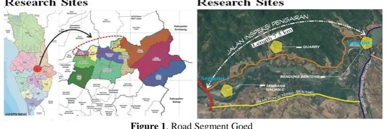
This research is descriptive, using qualitative and quantitative approach by analyzing the service level and the contribution of irrigation inspection to traffic movement and policy of change of road status for problem solving. The location of the research was conducted on the irrigation channel inspection of road between Duampanua and Batulappa sub-districts of Pinrang Regency which was divided into 2 research segments, as in Figure 1.
Figure 1. Road Segment Goed
Design and Variable Research
Data analysis techniques were used in this research is qualitative and quantitative analysis. The qualitative analysis is descriptive of each parameter based on related theory and obtained, while quantitative analysis is the result of surveys which can be calculated mathematically.
Population and Sample
The research populations include: (i) All the number of vehicle movements on the inspection of irrigation channel between Duampanua and Batulappa Sub-districts of Pinrang Regency, South Sulawesi, (ii) Traffic flow taken on each of the roads studied on Monday, January 9th, 2017; Tuesday, January 10th, 2017; Wednesday, January 11th, 2017 and Sunday, January 15th, 2017 at 07:00 am to 18:00 pm.
Method of collecting data
The data used are primary and secondary data. Primary data were obtained by conducting a traffic flow survey by counting the number of vehicles of various types passing through a road segment, as per the traffic enumeration technical guidelines (Department of Settlement and Regional Infrastructure, 2004) and identifying the specific types of agricultural vehicles and the maintenance of irrigation networks. In the form of documents and references deemed appropriate to the problem under study.
Data analysis method
The analysis of road geometric condition traffic using the procedure of geometric planning of out-of-town roads[7]. The calculation of road capacity is done by direct measurement of road in the research location and using the basic equation[8] for the capacity of out-of-town road segment. The level of service is a qualitative measure describing operational conditions within a traffic flow and perceptions of drivers and/or passengers on these conditions[9]. The service level is a qualitative measure of the speed or travel time (average space velocity) with the ratio between the maximum traffic volume that the road can accommodate to capacity[10]. Analyzes the level of service of a road is related to the speed of operation or road facility, which depends on the ratio of the current to the capacity. Therefore the level of service on a road depends on the flow of traffic [11].
Road capacity can be identified[8]:
C = CO x FCW x FCSP x FCSF C : Capacity (pcu/hour) CO : Basic Capacity (pcu/hour) FCW : Factor of road width adjustment
FCSP : Segregation of direction separation factor
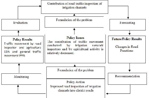
The traffic volume is calculated from the multiplication of the amount of traffic in each vehicle type with the vehicle conversion factor influenced by the slope of the road and the road direction division. Each type of vehicle has different movement characteristics because of the dimensions, speed and maneuverability of the road geometric. Therefore, it’s used the conversion of passenger car units[12]. Analysis contribution of inspection roads to traffic by identifying the flow of vehicles that are intended for the maintenance of irrigation and agricultural networks. Policy analysis[13] illustrates the use of methodological components of the methodology in carrying out the analysis of a policy within a system. The components referred to in the procedure of the policy analysis methodology are problem formulation, forecasting, recommendation, monitoring and evaluation.
III.
RESULTS
Level of Service and Contribution of Inspection Road
The level of road service can be seen in Table 1. The maximum traffic volume of segment 1 occurs on Wednesday at 09.00 am to 10.00 am of 165 pcu/hour while the minimum traffic volume occurs on Sunday at 11.00 am to 12.00 am by 54 pcu/ hour, the maximum traffic volume of segment B occurs on Wednesday at 09.00 am to 10.00 am of 91 pcu/hour while the minimum traffic volume occurs on Sunday at 13.00 pm to 14.00 pm of 36 pcu/hour. The capacity of each segment shows that segment 1 is capable of accommodating maximum traffic flow up to 1861 pcu/hour in both directions with the current physical path of the road (no increase or geometric alignment of the road), as well as segment 2 is still able to accommodate the current maximum traffic up to 2,032 pcu/hour in both directions. The inspection roads of irrigation channel have different saturation degree value for each segment, that is 0,09 for segment 1 and 0,04 for segment 2 with level of service category category A.
Table 1. Traffic flow, capacity, degree of saturation and level of service
No. Roads
Traffic flow (Q) (pcu/hour)
Capacity (pcu/hour)
Degree of Saturation
(DS)
IHCM rules
Level of service
1 Segment 1 165 1.861 0,09 ≤ 0,75 A A 2 Segment 2 91 2.032 0.04 ≤ 0,75
Source: Analysis Results, 2017
The contribution of current vehicles passing through irrigation inspection roads is dominated by non-designated vehicles as roads for agriculture and maintenance needs of the channel with a percentage of 89% whereas traffic flows for agricultural needs and maintenance of irrigation channels are 11%.
Policy Analysis
Policy analysis in Figure 2 provides components of the methodology of the policy analysis methodology, among others: (i) problem formulation, (ii) forecasting, (iii) recommendations, (iv) monitoring and evaluation in determining the road change inspection policy in the district road.
IV.
DISCUSSION
This research indicates that there are some aspects that influence the level of road service that is the indicator of road capacity[8]. The maximum traffic volume in segment 1 and segment 2 occurs on Wednesday is influenced by the market day in Kassadesa Bilajeng’s village. The minimum volume on segments 1 and 2 occurs on Sundays as they are not influenced by local or regional activities. The number of residents, land use on the side of the road and social facilities more in segment 1 causes the high traffic activity is compared with segment 2. The road capacity is influenced by several factors, namely capacity adjustment factor due to directional division, capacity adjustment factor for road width and capacity adjustment factor due to obstacles side.
Land use beside irrigation inspection roads other than the rice fields also contain sand mines that serve local needs and regional needs, where mountain rocks are taken, brick making and plantation areas. This irrigation inspection of road also connects the road between the Duampanua sub-district and nearby Batulappa Sub-district when using a four-wheeled vehicle so that the inspection road not only serves its intended use but also serves other vehicles.
Based on the Minimum Standards of Regional Infrastructure[14], accessibility is the ratio of road length to the area of 126.83 km versus 291.86 km2 or equivalent to 0.43 in the index > 0.005 meaning fulfill. The degree of saturation of segment 1 and segment 2 is 0.09 and 0.04 respectively included in the service level category A indicates free flow, low volume and the driver can select the desired speed.
Based on the policy analysis, function changes and status of inspection roads become the district roads as follows:
Problem Formulation
Before determining the policy problem first formulation of the problem provides information about the conditions that cause the problem, i.e., a) On the road inspection of irrigation channel in hierarchy is the nearest road to Batulappa district by using four-wheeled vehicles, b) A road link between the Duampanua sub-district, Batulappa sub-sub-district, and Enrekang Regency, and c) Land Use on the side of the irrigation inspection of road is the area of paddy areas, plantations, sand mines, mountain climbing sites, brick manufacturing and residential industries. These centers are the greatest attraction for movement on inspection roads of irrigation channels that fall within the service area.
Information about the condition of the road inspection resulted in the use of roads other than the inspection of road function, the fact that this is the case that the road is used as a public road is no longer functioning as it should be. Policy problems that occur with the above information can be concluded that is: Contribution of mobilization of traffic movement conducted by the inspector of irrigation network or by the agricultural activity of the relative decline.
Forecasting
Road inspection functions that previously only served for network and agricultural inspection activities, now play an important role in service to a wider area than the previous region. This road connects to the several sub-districts such as Duampanua sub-district, Batulappa sub-district and Patampanua sub-district.
In order to mobilize the results of the potential of the area it serves with the prediction that supply and demand resources is increasingly needed in the context of developing the transportation system. The need for the potential of natural resources owned in the area that becomes a road irrigations service makes the movement of traffic on irrigation road is no longer in accordance with its function. The future of policy result that should change the function in realizing the legal certainty in the implementation of the road and realize the role of the organizer of the road optimally In service delivery to the public.
Recommendation
The district road is a local road within a primary road network system that excludes national roads and provincial roads connecting the Capital of the District to the Capital of the sub-district between the Capital of the District, the Capital of the District with local activity centers, between local activity centers, and public roads in the secondary road network system and district strategic roads[15]. Changes in the status of the road on a road can be done after a change road function is set[16]. The results of the above recommendation that the policy action is to increase the road of inspection of irrigation channel into district road.
Monitoring
Evaluation
Changes in the function and status of irrigation channel provide legal certainty in the conduct of roads so that the activities for road users run as usual. The agricultural economic sector, industrial economy sector and other sectors can use the road inspection as the optimal role of road operator in providing service to the public so that roads still contribute to traffic movement from all economic, social and cultural sectors.
V.
CONCLUSIONS AND RECOMMENDATIONS
The saturation level of the Pangkajene-Empagae arterial road in the peak hour has a value of 0.77 with service level C where the current is stable and the speed is controlled by traffic, while the saturation level of Sarawatu-Bilariawa local road segment at peak hour has a value of 0.21 with service level A shows free flow, low volume and the driver can select the desired speed. Based on the predicted traffic growth by assuming 3.5% growth indicates that in 2019 on the Pangkajene-Empagae primary arterial road with a degree of saturation of 1.17 and in 2025 on Sarawatu-Bilariawa local streets with a degree of saturation of 1.13 It needs to be done capacity handling and traffic management. The strategy of development policy and development of local road transportation based on the analysis can be done road development to support tourist area and livestock. Completeness waveguide and road markings need to be considered to restrict the truckload exceeds the capacity of road carrying capacity. Therefore, it is necessary to immediately change the function and the status of irrigation channel become district roads that provide legal certainty in the implementation of the road so that the activities for road users run as usual. The agricultural economic sector, industrial economy sector and other sectors can use the road inspection as the optimal role of road operator.
ACKNOWLEDGEMENTS
The author would like to thank the highest possible to Pusbiktek-BPSDM Ministry of Public Works and People's Housing which has provided scholarship assistance and the opportunity to attend the Transportation Engineering Master's Degree program of Hasanuddin University Year 2015-2017 and to the Pinrang District Government which has given permission to continue higher education.
REFERENCES
[1] Salim, H.A.A. (1993), Transportation Management. Jakarta: PT. Raja Grafindo Persada
[2] Jinca, M. Y. (1999). Transportation System and Engineering. Makassar. Lecture Materials Faculty of Engineering Hasanuddin University.
[3] Magribi, L.O.M. (2003). Rural Access Requirements, Review of Efforts Poverty Alleviation, Paper presented at Workshop of FSTPT VI, Hasanuddin Univerity, Makassar [4] Jinca M.Y. (2009). Integration of Intercoding transport system system in Sulawesi Island. Journal of
Transportation Vol. 9, 1-14
[5] Hafudiansyah E. (2015). Influence of motorcycle proportion to passenger car equivalence value outer city road. Bandar Lampung. The 18th FSTPT International Symposium, No. 48, 469-478.
[6] Sulfianilsih. (2016). The analysis of road performance based on the degree of saturation of the road, Pekanbaru. Journal of Civil Engineering Cycle, Vol 2.
[7] Public Works Department. (1997). Geometric way of planning intercity road. Jakarta
[8] Directorate General of Highways. (1997). Manual road capacity Indonesia. Jakarta: PT. Bina Karya [9] Khisty and Lall, (2005), Fundamentals of Transport Engineering The third edition. Translation by Miro.
Jakarta: Erland
[10] Morlok, E.K. (1995). Introduction to Transportation Planning Techniques, Translations by Hainim, J.K .. Jakarta: Erland,
[11] Tamin O.Z. (2008). Transport planning and modeling. Bandung: Institute Technology Bandung (ITB). [12] Abubakar et al. (1999). Traffic engineering. Jakarta: BSLLAK Directorate General of Land
Transportation of the Department of Transportation
[13] William N. Dunn. (2000). Introduction to Public Policy Analysis. Bandung: Universitas Gadjah Mada press
[14] Decree of the Minister of Settlement and Regional Infrastructure, (2001). Minimum Standards of Regional Infrastructure. Jakarta
[15] Law of the Republic of Indonesia No.38 of 2004. On the Road. Jakarta [16] Government Regulation No. 03 Year 2012 about changes Function and Status.