5
PROJECT ALTERNATIVES
5.1 Introduction
The consideration of project alternatives is a key requirement of an EIA as it provides a basis for choice for the competent authority. The NEMA EIA Regulations of 2006 define alternatives in relation to a proposed activity as “different means of meeting the general purpose and requirements of the activity, which may include alternatives to the:
(a) property on which or location where it is proposed to undertake the activity; (b) type of activity to be undertaken;
(c) design or layout of the activity;
(d) technology to be used in the activity; and (e) operational aspects of the activity;”
Alternatives are considered as a means of reaching the same need and purpose as the originally proposed project in a way that minimises its negative and maximises its positive impacts. Alternatives that are considered must be reasonable and feasible. Tower design and corridor alternatives were considered and assessed during the Scoping Phase of this EIA.
5.2 Tower Design Alternatives
There are several tower design options available for use in the transmission line development, as described below. A variety or combination of tower designs are likely to be utilised for construction of the lines, depending on the characteristics and needs of the land and communities concerned (Figures 5.1 – 5.5). This section details the types of tower designs that could be placed along the length of the transmission line development. The final tower design alternatives will be decided based on a walk down of the proposed corridors, and upon discussion with the relevant parties involved. The various tower designs can be utilised for both 400 kV and 765 kV power lines.
Figure 5.1: Illustration of a compact cross rope suspension tower
Figure 5.2: Illustration of a cross rope suspension tower
Tower height: 37,89m Minimum ground clearance:8.1m Anchors: 49m Width at top :19m Tower height: 38 m Minimum ground clearance:8.5m Width at top :29m
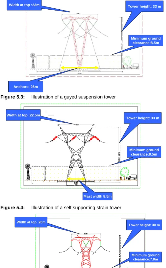
Figure 5.3: Illustration of a guyed suspension tower
Figure 5.4: Illustration of a self supporting strain tower
Figure 5.5: Illustration of a self supporting tower
Tower height: 33 m Minimum ground clearance:8.5m Width at top :23m Anchors: 26m Tower height: 33 m Minimum ground clearance:8.5m Width at top :22.5m Mast width 8.5m Tower height: 30 m Minimum ground clearance:7.8m Width at top :20m Mast width 8.8m
5.3 Corridor Alternatives
The proposed power lines include:
• Four 400 kV power lines from the proposed HV-yard at Bantamsklip to the Bacchus substation; and
• One 400 kV power line from the Bacchus substation to the Muldersvlei substation. Once the most suitable corridor(s) have been recommended and authorised, the exact alignment of the power lines within the corridor(s) will be finalised (as described in Chapter 3).
5.3.1 Initial corridor alternatives
The initial routes are identified by Eskom prior to the EIA consultants being appointed. The Eskom process of corridor identification is as follows:
Collation of Data
Before Route Selection can commence the detailed Project Scope is required from Eskom’s System Planning Department. This information includes:
• Voltage of Proposed Line
• Power line Terminal Points/Substations
• Possible Tower Types to be utilized
• Type of Conductor
• Design Specifications
• Separation distance between lines
• Building Restriction widths
• Critical Span lengths
• Size of Site e.g. 400kV = 600m x 600m
• Telecommunication tower
• Access road requirements
The Eskom Drawing Office upon request from the Eskom Environmental Practitioner will compile the relevant data for the route selection process. This includes:
• Topographical Maps such as 1: 50 000/1:250 000 Map Sheets in raster and/or vector format
• Existing Eskom Infrastructure – Power lines (Tx & Dx), Substations, Vacant Servitudes
• General Land Use Maps
• High level Environmental Maps
• Fire & Lightning data for the study area
Care is exercised in selecting suitable plans for this preliminary work. Depending on the rate of development in the area, plans of a suitable vintage must be sought. Older maps might not reflect the current status of the topographical cover and can be misleading.
Route Selection Meeting (Desktop Study)
The route selection meeting is convened as soon as the above data is collated. An informal meeting is held during which the team utilises both the Topographical and Google maps collectively to analyse various corridor options. The general discussion points at this meeting include:
• the Project overview
• known environmental issues
• Identification of vacant servitudes
• Identification of existing Transmission and Distribution Power Lines within the Study area.
• Identification of “no go zones” such as aerodromes, open cast mining, human settlements, environmental heritage sites and reserves etc.
• Identification of possible corridors - utilizing a 3D modelling tool (Topographical and Google maps), analyse each corridor and mark up possible issues, alternatives and route deviations
Site Investigation
The outcome of the desktop study yields alternative corridors. A field investigation is necessary to determine the feasibility of each alternative. The field investigation must be represented by:
• Line Design Engineer
• Eskom EIA Specialist
• Project Surveyor
• Project Negotiator
• Project Environmentalist
• Grid Representative
The following is recommended for the field investigation:
• The first inspection is to be carried out by vehicle. The team will after this inspection gain an overall view of the study area.
• Following the vehicle inspection, an aerial investigation by helicopter must be undertaken to confirm findings on the ground and finalise corridor alternatives. Positions of possible alternative routes must be captured by GPS. Positions of “no go areas” must also be captured and plotted on the corridor maps.
On completion of the field investigation the team will be able to recommend corridor alternatives which are technically feasible and financially viable to the independent EIA consultants.
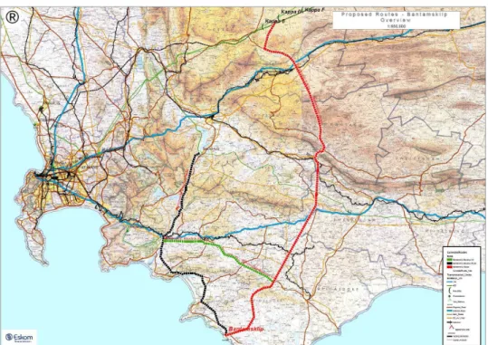
Based on the above, three potential corridors were put forward for further investigation (Figure 5.6). A fly-over was undertaken in May 2008, where technical team noted some areas of the proposed routes were not feasible. The technical constraints and restrictions included:
• Distance between the power lines;
• Total width of corridor;
• Side slope angle;
• Proximity to houses; and
These corridors were therefore discarded and revised corridors proposed.
Figure 5.6: Initial corridor alternatives for Applications 1 and 2 (pre-fly-over and
technical assessment). See the red, black and green dotted lines.
5.3.2 Revised corridor alternatives
Based on technical feasibility and site observations, new corridors were identified within which the power lines can be constructed (Figure 5.7). These were:
• Four alternative corridors between Bantamsklip and Bacchus; and
• Two alternative corridors between Bacchus and Kappa.
These were also subject to a fly-over, after which technical constraints and a revised needs analysis eliminated the Bacchus-Kappa alternatives from this application. In addition, the site visit allowed for two alternative corridors to be proposed, linking the Bacchus and Muldersvlei substations.
Figure 5.7: Revised corridor alternatives (Application 2). 5.3.3 Current corridor alternatives
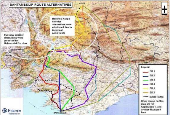
The alternative corridors that were evaluated in this Scoping phase for Bantamsklip-Bacchus are therefore:
• Alternative corridor 1 - BB1 (represented by the blue line in Figure 5.8);
• Alternative corridor 2 - BB2 (represented by the green line in Figure 5.8);
• Alternative corridor 3 - BB3 (represented by the purple line in Figure 5.8); and
• Alternative corridor 4 - BB4 (represented by the red line in Figure 5.8).
The alternative corridors that were evaluated in this Scoping phase for Bacchus-Muldersvlei are therefore:
• Alternative corridor 1 - BM1 (represented by the green line in Figure 5.9); and
• Alternative corridor 2 - BM2 (represented by the orange line in Figure 5.9). In addition, the extension of the Bacchus substation and the no-go alternative for each of the proposed routes and the extension of the substation were also evaluated.
Figure 5.8: Proposed alternative corridors for the Bantamsklip-Bacchus power lines.
The maps indicated in this figure (1:100 000 scale) can be viewed in Appendix D1.
Figure 5.9: Proposed alternative corridors for the Bacchus-Muldersvlei power lines.
5.3.4 Description of the Alternative Bantamsklip-Bacchus Corridors Alternative Corridor 1 (BB 1)
Alternative 1 runs in a north-westerly direction from the proposed Bantamsklip Nuclear facility for approximately 27 km before turning north and following the alignment of the R43 to the south-east of the town of Stanford. The route then crosses the Kleinrivier Mountains approximately 5 km north east of Stanford. The Stanford valley (i.e. south of the Kleinrivier Mountains and east of Stanford) consists of a combination of vineyards, annual crops (cereals, fodder crops) and pasturage. The south-western Overberg area is also an important holiday and tourist area, with the town of Gansbaai, to the south, internationally recognised as a shark diving destination.
To the east of the Steenboksberg the alignment swings west and runs along the foothills of this mountain and Shaw’s mountain for approximately 20 km before swinging north-west towards the town of Villiersdrop. The first 9 km of this section cut across gently undulating grain fields, before crossing the N2 approximately 7 km east of the town of Botrivier. From here the alignment rises and crosses more mountainous areas before dropping into the Villiersdorp Valley. The section through the Villiersdorp Valley follows the alignment of existing lines (from approximately 23 km south of Bacchus), skirting the eastern shore of the Theewaterskloof dam, and passing approximately 2 km east of the town of Villiersdorp.
The route then crosses the R43 (Villiersdorp-Worcester) approximately 6.5 km north of Villiersdorp. From here the alignment runs along the western side of the Valley along the eastern slopes of the Hottentots Holland mountains for approximately 15 km before linking up with the Bacchus substation. The land uses in the valley consist of a combination of intensive farming (vineyards, orchards) and annual crops. The total length of Alternative 1 is approximately 123.15 km.
Alternative Corridor 2 (BB 2)
Alternative 2 runs due north from the proposed Bantamsklip Nuclear facility for approximately 36 km before crossing the Kleinrivier Mountains approximately 8 km east of Stanford. With the exception of the eastern portion of the Stanford valley, this section of the route crosses an area of low-medium agricultural activity.
To the north of the Kleinrivier Mountains the route continues in a northerly direction until it crosses the N2 approximately 9 km east of the town of Caledon. The section south of the N2 consists of gently undulating grain fields. Beyond the N2, the route crosses Caledonberg, and then continues due north across flat terrain mainly used for the cultivation of annual crops and pasturage.
Approximately 3 km due south of the Snyerskraalkoppe, the route switches to a north-westerly direction and crosses the R406 which links the towns of Genadendal and Greyton to the N2. Further westwards the route crosses the Riviersonderend River to the east of Helderstroom Prison. The area where the alignment crosses is intensively farmed.
Leaving the Riviersondend Valley the line crosses into the westernmost slopes of the Riviersonderend Mountains, approximately 5 km south-east of Villiersdorp. The route then heads north-north-east along the eastern edge of the Villiersdorp Valley. En route it crosses the R43 approximately 6.5 km north of Villiersdorp. Beyond the crossing, the alignment runs along the western side of the Valley for approximately 15
km before linking up with the Bacchus substation. The land uses in the valley consist of a combination of intensive farming (vineyards, orchards) and dry grain crops. The total length of Alternative 2 is approximately 113.6 km.
Alternative Corridor 3 (BB 3)
Alternative 3 runs in a north-easterly direction from the proposed Bantamsklip Nuclear facility for approximately 35 km before switching to a northerly direction east of Akkedisberg and approximately 13 km north-west of the town of Napier. This section of the route crosses an area of low-medium agricultural activity. There are also a number of small settlements in the area, such as Wolvengat and Baardeskeerdersbos.
To the north of the Akkedisberg the route continues to run in a northerly and north westerly direction until it crosses the N2 approximately 18 km east of the town of Caledon. The section of the route south of the N2 consists of gently undulating grain fields. North of the N2 the route traverses the eastern foothills of the Caledonberg before continuing in a north-westerly direction across flat terrain mainly used for the cultivation of annual crops and as pasturage.
Approximately 3 km due south of the Snyerskraalkoppe, the route crosses the R406 which links the towns of Genadendal and Greyton to the N2. Further westwards the route crosses the Riviersonderend River to the east of Helderstroom Prison. The area where the alignment crosses is intensively farmed. The route then swings north, traversing the western foothills of the Riviersondereind mountains to the east of the Villiersdorp valley and the town of Villiersdorp. The route enters the Villiersdorp Valley approximately 10 km north-north-east of Villiersdorp before crossing R43. The land uses in the Valley on either side of the R43 consist of vineyards and orchards.
The alignment then changes north-north-east, and runs along the western side of the Valley (lower slopes of the Hottentots Holland mountains) for approximately 10 km before linking up with the Bacchus substation. The land uses in the valley consist of a combination of intensive farming (vineyards, orchards) and annual crops. The total length of Alternative 3 is approximately 125 km.
Alternative Corridor 4 (BB 4)
Alternative 4 runs in a north-easterly direction from the proposed Bantamsklip Nuclear facility for approximately 45 km before crossing the Bredasdorp Mountains approximately 5 km west of the town of Bredasdorp. This section of the route crosses an area of low-medium agricultural activity. There are also a number of small settlements in the area, such as Baardskeerdersbos, Wolvengat, and Elim.
To the north of the Bredasdorp Mountains the route continues to run in a northerly direction until it crosses the N2 near Stromsvlei, approximately 17 km east of the town of Riviersonderend. Land uses along this section south of the N2 consist largely of annual crops and pasturage.
North of the N2 the route runs parallel and to the west of the R317 (N2-Bonnivale) for approximately 7.5 km before swinging north-west towards the town of McGregor, a small, well established tourist destination. The section between Stormsvlei and McGregor measures approximately 25 km and runs though low gently sloped hills. The farming activities in the area are limited and are essentially confined to two
reserve and approximately 3.5 km north of McGregor. The route continues in a north-westerly direction, traversing the intensively cultivated Koningsrivier Valley.
South-west of the Klipberg, the route changes direction, skirting the Klipberg towards its east, and then switches west, skirting the northern flanks of the Klipberg. From here the route continues in a generally westward direction, until it reaches the Bacchus substation. With the exception of a few fertile floodplains formed by north flowing rivers flowing out of the hills, there is limited farming in the area. However, the area immediately east of Bacchus is extensively farmed. This section extends for approximately 7 km towards the east of Bacchus. Just north-east of Bacchus the route traverses the R43. The total length of Alternative 4 is approximately 180.1 km.
5.3.5 Description of the Alternative Bacchus-Muldersvlei Corridors Alternative Corridor 1 (BM 1)
Alternative 1 crosses the N1 north of the Muldersvlei substation as two lines. The first segment of the route runs north-north-east for approximately 2 km across cultivated vineyards on Joostenberg Estate. The route continues in roughly a north-easterly direction for approximately 17 km towards the north-westernmost outcrop of Paarlberg, just south-west of Rheebokskloof. Along the way, it traverses the R312 (Durbanville road) and R44 (Klapmuts-Wellington). The terrain is relatively flat to moderately undulating, and the land is predominantly used for pasturage and the cultivation of fodder and cereal crops.
From the north-western outcrop of Paarlberg the route continues north-east across the high agricultural potential and scenic Rheebokskloof area. It traverses the R44 south-west of Wellington near the intersection with the R45 (Paarl-Malmesbury) to link up with an existing substation. One line leaves this substation, switching back across the R44, running in a south-easterly direction across the northern portion of the Rheebokskloof area and beyond that, the Newton-West / Mbekweni urban areas of Wellington (for approximately 1.5 km) before traversing the R301 (Wellington-Paarl) and skirting the Newton urban area to the north. Further towards the east the route continues across high potential agricultural land between Paarl and Wellington towards the western foothills of the Klein Drakenstein mountains north of Dal Josafat. The route then continues in a south-easterly direction, traversing the western slopes of the Klein Drakenstein mountains up to north-west of the northernmost point of the Du Toitskloof pass (R301). The terrain is relatively steep, but includes areas used for forestry and for the cultivation of olives. The route skirts the northernmost point of the Du Toitskloof pass, and continues south-south-east, to the east of, and parallel to the R301, and following the alignment of the valley between the Klein Drakenstein mountains and the Witteberg.
Just east of the northern entrance to the Hugenot tunnel, the route crosses the N1, and continues along the northern flank of Du Toit’s mountain, parallel to and to the south of the N1 and the Molenaars River valley. The relevant terrain is steep, and mostly covered by fynbos.
From approximately the confluence point of the Molenaars and Smalblaar rivers north-west of Du Toit’s mountain, the route follows a north-easterly direction, cutting across the intensely cultivated flood plain to the south of Rawsonville, up to Pokkraal hill north-west of the Brandvlei Dam (approximately 9 km). From Pokkraal hill the line runs along the western side of the Brandvlei Dam for approximately 18 km, skirting the Warmwaterbron recreational / residentrial area and Brandvlei prison complex
located on the western shore of the Dam, before terminating at the existing Bacchus substation. The total length of Alternative 1 is approximately 89 km.
Alternative Corridor 2 (BM 2)
Alternative 2 crosses the N1 north of the Muldersvlei substation as a single line. The first segment of the route runs north-north-east for approximately 2 km across cultivated vineyards on Joostenberg Estate. The route continues in roughly a north-easterly direction for approximately 17 km towards the north-westernmost outcrop of Paarlberg, just south-west of Rheebokskloof. Along the way, it traverses the R312 (Durbanville road) and R44 (Klapmuts-Wellington). The terrain is relatively flat to moderately undulating, and the land is predominantly used for pasturage and the cultivation of fodder and cereal crops.
The route crosses the Berg River and associated intensive agricultural area approximately 6.5 km north-west of Wellington, and continues in a north-easterly direction, crossing the R44 (Wellington-Tulbagh) and adjacent railway line, cultivated fields (annual crops), up along the western slopes of the Limietberge. The line then traverses the Limietberge from west to east between Balily’s peak and Blake’s berg. Towards the eastern side it traverses the Waterval Nature Reserve before turning south-south-east and skirting the eastern flanks of the Limietberge just above the Romansrivier-Wolseley valley south of Romansrivier. From here the route turns east, crossing the R303 north of the entrance to the Bainskloof pass, and the valley west of the Waaihoekberge. The relevant area is utilised for mainly agricultural purposes, including viticulture and annual crops.
Along the upper cultivated western slopes of the Waaihoekberge, the route turns south-east, broadly in the direction of the north-westernmost corner of the Brandsvlei dam. The first 10 km of this section are located on the south-western lower slopes of the Waaihoek mountains, before is crosses the R43 (Worcester – Tulbagh). From here the line cuts across a combination of intensively farmed areas (mainly vineyards located on the northern bank of the Breede River Valley) before crossing the Breede River, the N1 and the R101 (Worcesater-Rawsonville) and terminating on Pokkraal Hill immediately north-west of the Brandvlei dam. This section covers approximately 15 km.
From Pokkraal Hill the line then runs along the western side of the Brandvlei Dam for approximately 18 km, skirting the Warmwaterbron recreational/ residential area and Brandvlei prison complex located on the western shore of the Dam, before terminating at the existing Bacchus substation. The total length of Alternative 2 is approximately 102.5 km.
5.3.6 Additional Identified Alternative
During the Pre-Scoping Phase a number of Focus Group and One-on-one meetings and workshops were held with Interested and Affected Parties (I&APs) as well as Stakeholders.
One particular workshop arranged by the Agulhas Biodiversity Initiative (ABI) and the Overberg Integrated Conservation Group (OICG) was held on 7 November 2008. This meeting resulted in the formation of a steering committee that was to propose an alternative corridor for the power lines. An alternative corridor was subsequently proposed (See figure 5.10) and this alternative forwarded to all the specialists on the
Figure 5.10: Alternative corridor identified by the ABI / OICG Steering Committee
(see the red and white dotted line)
The following comments were received from the various specialists: • Flora
A preliminary examination of the proposed routing suggested by ABI suggests that it is the least sensitive routing through the key Agulhas Plain and southern Overberg, and would thus be the preferred alternative. Nevertheless, there are a number of unavoidable sensitive areas along the route, such as parts of the Koudeberg and the eastern Klein River mountains, and these would clearly require special attention and mitigation (helicopter access only, at least for the latter).
The route to Bacchus is not ideal in the Florishoogte area north of the N2 and it is suggested that it be rerouted to a lower lying area to the east of the Dassiesfontein ridge, and thence east of the Van der Stels Pass. The final section from Villiersdorp follows much the same route as other alternatives and consequently runs through a High sensitivity area south of Bacchus, but there are unfortunately no potential routes that avoid this sensitive area.
At the point where the two routes split (southeast of Caledon) the Bacchus alternative should not cross the Caledon – Bredasdorp road twice, and hence needs to swing west immediately after diverging from the Kappa route. From a botanical perspective this is a fairly low sensitivity area (mostly agricultural) and there are various suitable routes to consider.
• Fauna
Although the fauna specialists did not specifically comment on this potential alternative, it is anticipated that due to the close links that exist between fauna and flora with regards to habitat and ecological processes that this alternative may be considered an alternative worthy of further study.
• Avifauna
In terms of a potential alternative for the Bantamsklip Bacchus lines the ABI Alternative was considered the least preferred from an avifauna point of view.
• Agricultural Potential and Land Capability
From Bantamsklip the ABI Altenrative follows the Bantamsklip – Bacchus alignments up to Hagelkraal were it swings away towards the east around Perdekop and joins the Bantamsklip – Bacchus route again south of the Kleinriver mountain east of Stanford. This is an improvement on the Bantamsklip - Bacchus Alt1 as it does not cross the sensitive Baarskeerdersbos – Grootbos valley and Stanford coast areas. On the northern side of the Kleinriver mountain the ABI Alternative splits from the Bantamsklip - Bacchus Alt1 and runs almost parallel with it just south of Caledon and they join again at Langhoogte between Caledon and Botriver from where it follows the same route to Bacchus (Alt1).
From an agricultural view point there are no serious objections to this proposed alternative route to the Bacchus substation.
In terms of this application the proposed corridor proposes an entirely new alternative for the Bantamsklip –Bacchus lines. It is recommended that the ABI alternative be proposed for further investigation in the EIA phase of the project.
5.3.7 Description of the Site Alternatives for the Bacchus Substation Extension
No separate alternatives have been identified for the extension of the Bacchus Substation, as it is planned as an extension of an existing substation. However, the aim will be to ensure that the extension remains within the existing perimeter fence.
5.4 Description of the No-Go Alternative
In the context of this project, the no-go alternative implies that the power lines linking the proposed Bantamsklip Nuclear Power Station to the national grid via the Bacchus substation or that the Bacchus – Muldersvlei power line will not be constructed. The no-go alternative can be regarded as the baseline scenario against which the impacts of the power lines are evaluated. This implies that the current biophysical and socio-economic conditions associated with the proposed routes will be used as the benchmark against which to assess the possible changes (impacts) to these conditions as a result of the power lines.
development and related job creation, and increased security of electricity supply for the Cape coastal areas) of the project not being realised. Importantly, South Africa’s need to include a more diverse fuel mix to its energy generation capacity and national electricity grid will also not be realised.
The no-go alternative will be investigated in further detail in the impact assessment phase of the EIA process.
5.5 Conclusion
This chapter discusses the various project alternatives as required by the EIA regulations. These alternatives include the tower design alternatives, corridor alternatives and a description of the No-Go alternative. The various initial corridor route alternatives are recommended by Eskom through the collation of data and desk top studies. More intensive investigation of these corridor alternatives is then carried out through field investigations and specialist studies to determine viable alternatives for the EIA phase.