OCS EIS/EA BOEMRE 2011-037
Commercial Wind Lease Issuance
and Site Characterization Activities
on the Atlantic Outer Continental
Shelf Offshore New Jersey, Delaware,
Maryland, and Virginia
Draft Environmental Assessment
U.S. Department of the Interior
OCS EIS/EA BOEMRE 2011-037
Commercial Wind Lease Issuance
and Site Characterization Activities
on the Atlantic Outer Continental
Shelf Offshore New Jersey, Delaware,
Maryland, and Virginia
Draft Environmental Assessment
Author
Bureau of Ocean Energy Management, Regulation and Enforcement Office of Offshore Alternative Energy Programs
Published by
U.S. Department of the Interior
Bureau of Ocean Energy Management, Regulation and Enforcement
TABLE OF CONTENTS
Page
LIST OF FIGURES ... vi
LIST OF TABLES... vii
1 INTRODUCTION ...1
1.1 Background...1
1.1.1 “Smart from the Start” Atlantic Wind Energy Initiative ...1
1.1.2 BOEMRE Authority and Regulatory Process...1
1.2 Purpose and Need ...2
1.3 Description of the Proposed Action...2
1.4 Objective of the Environmental Assessment ...2
1.4.1 Information Considered ...3
1.4.2 Scope of Analysis ...3
1.4.3 Planning Process ...4
1.5 Development and Refinement of Wind Energy Areas ...5
1.6 Existing Interim Policy Leases ...8
2 ALTERNATIVES INCLUDING THE PROPOSED ACTION ...13
2.1 Alternative A (Preferred Alternative) – The Proposed Action ...14
2.2 Alternative B – Removal of Anchorage Ground Offshore Delaware...15
2.3 Alternative C – Removal of Category B Areas Offshore Maryland...17
2.4 Alternative D – Seasonal Prohibition to Protect the North Atlantic Right Whale...17
2.5 Alternative E – Removal of Inclement Weather Diversion Areas Offshore Virginia ...18
2.6 Alternative F – No Action...19
2.7 Mitigation Measures ...19
3 SCENARIO OF REASONABLY FORESEEABLE ACTIVITY AND IMPACT PRODUCING FACTORS ...21
3.1 Routine Activities ...21
3.1.1 Leasing Scenario...22
3.1.2 Site Characterization Surveys ...22
3.1.2.1 High-resolution Geophysical (HRG) Surveys ...24
3.1.2.2 Sub-bottom Sampling ...26
3.1.2.3 Biological Surveys ...27
3.1.2.4 Timing...29
3.1.2.5 Onshore Activities ...30
3.1.2.6 Vessel Traffic Associated with Site Characterization ...30
3.1.2.7 Operational Waste...31
3.1.3 Site Assessment Activities and Data Collection Structures...32
3.1.3.1 Meteorological Towers and Foundations...33
3.1.3.3 Meteorological Tower and Buoy Equipment...45
3.1.3.4 Vessel Traffic Associated with Site Assessment ...45
3.2 Non-Routine Events...46
3.2.1 Storms ...46
3.2.2 Allisions and Collisions ...47
3.2.3 Spills ...48
4 ENVIRONMENTAL AND SOCIOECONOMIC CONSEQUENCES ...49
4.1 Alternative A – The Proposed Action...49
4.1.1 Physical Resources...49 4.1.1.1 Air Quality ...49 4.1.1.2 Water Quality...54 4.1.2 Biological Resources ...62 4.1.2.1 Coastal Habitats ...62 4.1.2.2 Benthic Resources...66 4.1.2.3 Marine Mammals ...70 4.1.2.4 Sea Turtles ...89 4.1.2.5 Birds...98 4.1.2.6 Bats ...103
4.1.2.7 Fish and Essential Fish Habitat...107
4.1.3 Socioeconomic Conditions and Impacts...116
4.1.3.1 Archaeological Resources...116
4.1.3.2 Recreational Resources...120
4.1.3.3 Demographics and Employment...125
4.1.3.4 Environmental Justice...125
4.1.3.5 Land Use and Coastal Infrastructure...126
4.1.3.6 Commercial and Recreational Fishing Activities ...129
4.1.3.7 Other Uses of the OCS...135
4.2 Alternative B – Removal of Anchorage Ground Offshore Delaware...151
4.3 Alternative C – Removal of Category B Areas Offshore Maryland...158
4.4 Alternative D – Seasonal Prohibition to Protect the North Atlantic Right Whale...165
4.5 Alternative E – Removal of Inclement Weather Diversion Area Offshore Virginia ...171
4.7 Alternative F – No Action...178
4.8 Cumulative Environmental and Socioeconomic Impacts ...179
5 CONSULTATION AND COORDINATION ...185
5.1 Public Involvement ...185
5.1.1 Notice of Intent ...185
5.1.2 Notice of Availability ...185
5.2 Cooperating Agencies...185
5.3 Consultations...186
5.3.1 Endangered Species Act ...186
5.3.2 Magnuson Fishery Conservation and Management Act...186
5.3.3 Coastal Zone Management Act...187
6 REFERENCES ...191
7 PREPARERS ...209
APPENDIX A Benthic Habitat Figures...211
APPENDIX B Marine Mammal Sightings Data Figures ...217
APPENDIX C Proposed Mitigation Measures for ESA Listed Marine Mammals and Sea Turtles ...223
LIST OF FIGURES
Page Figure 1.1 Original WEAs offshore New Jersey, Delaware, Maryland and Virginia
Identified
in the Notice of Intent ...9
Figure 1.2. Proposed Action Area Offshore New Jersey, Delaware, Maryland and Virginia. ...10
Figure 1.3. USCG-Identified Areas Offshore Maryland...11
Figure 2.1 U.S. Coast Guard Proposed Anchorage Ground...16
Figure 2.2 Inclement Weather Diversion Areas Offshore Virginia ...19
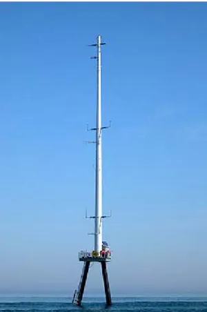
Figure 3.1. Cape Wind Meteorological Tower...34
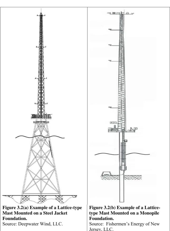
Figure 3.2. Examples of Lattice Mast Meteorological Towers...35
Figure 3.3. The Zones of Origin and Tracks for the month of September During the Hurricane Season ...47
Figure 4.1. Water Quality Index for the Northeast Coast ...56
Figure 4.2. Recreational Charter Boat Fishing Effort 2004-2008...130
Figure 4.3. Recreational Party Boat Fishing Effort 2004-2008 ...131
Figure 4.4. Annual Commercial Fishing – All Gear. ...133
Figure 4.5. Military Activity Areas and Uses ...137
Figure 4.6. Interim Policy leases, Traffic Separation Schemes and the Proposed Atlantic Wind Connect Project...142
Figure 4.7a. Delaware and Maryland AIS Vessel Count Data 2009 ...147
Figure 4.7b. New Jersey AIS Vessel Count Data 2009...148
Figure 4.7c. Virginia AIS Vessel Count Data 2009...149
Figure A.1. Benthic Habitat Types Within the New Jersey WEA...213
Figure A.2. Benthic Habitat Types Within the Delaware and Maryland WEAs. ...214
Figure A.3. Benthic Habitat Types Within the Virginia WEA. ...215
Figure B.1. Maryland and Delaware WEA Cetacean Sighting Per Unit of Effort. ...220
Figure B.2. New Jersey WEA Cetacean Sightings Per Unit of Effort...221
Figure B.3. Virginia WEA Bottlenose Dolphin Sightings Per Unit of Effort. ...222
Figure D.1. Delaware and Maryland WEA Sea Turtle Sightings Per Unit of Effort...233
Figure D.2. New Jersey WEA Sea Turtle Sightings Per Unit of Effort...234
LIST OF TABLES
Page Table 2.1 Alternatives Considered...13 Table 3.1 Projected Site Characterization and Assessment Activities for the Proposed
Action...21 Table 3.2 Typical Equipment to be Utilized during an HRG Survey...26 Table 3.3 Projected Number of Meteorological Towers and Buoys ...33 Table 3.4 Projected Vessel Usage and Specifications for the Construction of a
Meteorological Tower...38 Table 4.1 Total Number of Coastal Counties in Nonattainment of Each Criteria Pollutant
per State ...50 Table 4.2 Mid-Atlantic Benthic Habitat Types1...68 Table 4.3 Marine Mammals in the Mid and North Atlantic OCS Waters ...72 Table 4.4 Functional Marine Mammal Hearing Groups, Auditory Bandwidth, and
Genera Represented from Each Group ...80 Table 4.5 Modeled Areas of Ensonification from Pile Driving...83 Table 4.6 Sea Turtle Taxa of the Western North Atlantic ...91 Table 4.7 Relevant Counties Along the Mid-Atlantic Where Piping Plovers are Known
to Occur...100 Table 4.8 Occurrence (“X”) of Bats by State ...105 Table 4.9 Major Recurrent Demersal Finfish Assemblages of the Mid-Atlantic Bight
During Spring and Fall...109 Table 4.10 Number of Coastal Beaches in New Jersey, Maryland, Delaware and Virginia
by County...122 Table 4.11 Related Tourism and Recreation Economy by County, 2004 ...123 Table 4.12 Population and Economic Data for Shore Adjacent Counties of New Jersey,
Delaware, Maryland and Virginia...125 Table 4.13 Total Commercial Fishery Landed Weight and Value in 2009 ...132 Table 4.14 Top Ports by National Value Rank Adjacent to WEAs...132 Table 4.15 Projected Site Characterization and Assessment Activities for Alternative B
(Removal of Anchorage Ground Offshore Delaware)...153 Table 4.16 Projected Site Characterization and Assessment Activities for Alternative C
(Removal of Category B Areas Offshore Maryland)...159 Table 4.17 Projected Site Characterization and Assessment Activities for Alternative E
1 INTRODUCTION
1.1 Background
1.1.1 “Smart from the Start” Atlantic Wind Energy Initiative
On November 23, 2010, Secretary of the Interior Ken Salazar announced the “Smart from the Start” Atlantic wind energy initiative to accelerate the responsible development of wind energy on the Atlantic Outer Continental Shelf (OCS). The initiative calls for the identification of areas on the Atlantic OCS that appear most suitable for commercial wind energy activities, and the opening of these areas for leasing and detailed site assessment activities. On February 9, 2011, the Bureau of Ocean Energy Management, Regulation and Enforcement (BOEMRE) launched the first phase of this initiative through the publication of a Notice of Intent (NOI) in the Federal Register (76 FR 7226). The NOI identified areas of
the OCS offshore the Mid-Atlantic States – New Jersey, Delaware, Maryland, and Virginia – that appeared to provide the most suitable opportunity for wind energy development while presenting the fewest apparent user conflicts. See Figure 1.1. These areas, “Wind Energy
Areas” (WEAs), were originally delineated in the NOI, and later refined. See Figure 1.2.
They were developed and refined through extensive consultation with other Federal agencies and BOEMRE’s Intergovernmental Renewable Energy Task Forces of each affected state, which had been taking place since October 29, 2011. See Section 1.5 for further discussion
of BOEMRE’s Intergovernmental Renewable Energy Task Forces, and development and refinement of the WEAs. The NOI solicited public input regarding the environmental and socioeconomic issues associated with wind energy leasing in these areas (76 FR 7226).
1.1.2 BOEMRE Authority and Regulatory Process
The Energy Policy Act of 2005, Pub. L. No. 109-58, added Section 8(p)(1)(C) to the OCS Lands Act (OCSLA), which mandated that the Secretary of the Interior issue leases, easements, or rights-of-way on the OCS for the purpose of wind energy development. See 43
U.S.C. § 1337(p)(1)(C). The Secretary delegated this authority to the former Minerals Management Service (MMS), now BOEMRE. On April 22, 2009, BOEMRE promulgated final regulations implementing this authority at 30 CFR Part 285.
Under the renewable energy regulations, the issuance of leases and subsequent approval of wind energy development on the OCS is a staged decision-making process. BOEMRE’s wind energy program occurs in four distinct phases: (1) planning and analysis; (2) lease issuance; (3) approval of a site assessment plan (SAP); and (4) approval of a construction and operation plan (COP). The first phase is to identify suitable areas for wind energy leasing consideration through collaborative, consultative and analytical processes. The second phase, issuance of a commercial wind energy lease, gives the lessee the exclusive right to subsequently seek BOEMRE approval for the development of the leasehold. The lease does not grant the lessee the right to construct any facilities; rather, the lease grants the right to use the leased area to develop its plans, which must be approved by BOEMRE before the lessee can move on to the next stage of the process. See 30 CFR 285.600 and 285.601. The third
stage of the process is the submission of a SAP, which contains the lessee’s detailed proposal for the construction of a meteorological tower and/or the installation of meteorological buoys on the leasehold. See 30 CFR 285.605 - 285.618. The lessee’s SAP must be approved by
BOEMRE before it conducts these “site assessment” activities on the leasehold. BOEMRE may approve, approve with modification, or disapprove a lessee’s SAP. See 30 CFR
285.613. The fourth stage of the process is the submission of a COP, a detailed plan for the construction and operation of a wind energy project on the lease. See 30 CFR
285.620-285.638. BOEMRE approval of a COP is a precondition to the construction of any wind energy facility on the OCS. See 30 CFR 285.628. As with a SAP, BOEMRE may approve,
approve with modification, or disapprove a lessee’s COP. See 30 CFR 285.628.
The regulations also require that a lessee provide the results of surveys with its COP, including a shallow hazards survey (30 CFR 285.626 (a)(1)), geological survey (30 CFR 285.616(a)(2)), geotechnical survey (30 CFR 285.626(a)(4)), and an archaeological resource survey (30 CFR 285.626(a)(5)). BOEMRE refers to these surveys as “site characterization” activities. Although BOEMRE does not issue permits or approvals for these site characterization activities, it will not consider approving a lessee’s COP if the required
survey information is not included. See also
http://www.boemre.gov/offshore/RenewableEnergy/PDFs/GGARCH4-11-2011.pdf.
In addition to commercial leases, BOEMRE has the authority to issue leases to other Federal agencies and to States for the purpose of conducting renewable energy research activities that support the future production, transportation, or transmission of renewable energy. See 30 CFR 285.238. The terms of these types of research leases would be
negotiated by the Director of BOEMRE and the head of the Federal agency or the Governor of the relevant State, or their authorized representatives, on a case-by-case basis, subject to the provisions of 30 CFR Part 285, including those pertaining to public involvement.
1.2 Purpose and Need
The purpose is to issue leases and approve site assessment plans to provide for the responsible development of wind energy resources in previously identified WEAs offshore New Jersey, Delaware, Maryland and Virginia. The need is to adequately assess wind and environmental resources of the WEAs to determine whether and which areas within the WEAs are suitable for and would support commercial-scale wind energy production.
1.3 Description of the Proposed Action
The proposed action is the issuance of commercial and research wind energy leases within the WEAs offshore New Jersey, Delaware, Maryland and Virginia as shown in Figure 1.2, and approval of site assessment activities on those leases.
1.4 Objective of the Environmental Assessment
Pursuant to the National Environmental Policy Act (NEPA), 42 U.S.C. §§ 4321-4370f, and the Council on Environmental Quality (CEQ) Regulations at 40 CFR 1501.3, this EA was prepared to assist the agency in determining which OCS areas offshore the Mid-Atlantic States should be the focus of BOEMRE’s wind energy leasing efforts. This EA considers a number of reasonable geographic and non-geographic alternatives, and evaluates the environmental and socioeconomic consequences (including potential user conflicts) associated with issuing leases and approving site assessment plans under each alternative.
1.4.1 Information Considered
Information considered in scoping the NEPA document includes: 1. Public response to the February 9, 2011, NOI to prepare this EA;
2. BOEMRE research and review of current relevant scientific and socioeconomic literature;
3. Comments received in response to the Requests for Interest (RFI) and Calls for Information (Calls) associated with wind energy planning offshore each of the Mid-Atlantic States;
4. Ongoing consultation and coordination with the members of BOEMRE’s Intergovernmental Renewable Energy Task Forces in each Mid-Atlantic State; 5. Consultation with potentially affected tribes in each Mid-Atlantic State; 6. Ongoing consultations with other federal agencies including the U.S. Fish and
Wildlife Service (USFWS), the National Marine Fisheries Service (NMFS), the U.S. Department of Defense (DOD), and the U.S. Coast Guard (USCG); and
7. Relevant material from the Programmatic Environmental Impact Statement for Alternative Energy Development and Production and Alternate Use of Facilities on the Outer Continental Shelf, Final Environmental Impact Statement (Programmatic
EIS)(USDOI, MMS, 2007a).
1.4.2 Scope of Analysis
BOEMRE intends to use this EA to inform decisions to issue leases in the refined WEAs, and to subsequently approve SAPs on those leases. As discussed above, BOEMRE does not issue permits for shallow hazards, geological, geotechnical, or archaeological resource surveys. However, since BOEMRE regulations require that a lessee include the results of these surveys in its application for COP approval, this EA will treat the environmental consequences of these surveys as reasonably foreseeable consequences of issuing a lease.
Thus, this EA will analyze the reasonably foreseeable consequences associated with two distinct BOEMRE actions in the WEAs identified in the alternatives:
(1) Lease issuance (including reasonably foreseeable consequences associated with shallow hazards, geological, geotechnical, and archaeological resource surveys); and
(2) SAP approval (including reasonably foreseeable consequences associated with the installation of a meteorological tower and/or meteorological buoys).
This EA will not be used to support any future decision regarding construction or operation of any wind energy facility on leases that may be issued within the WEAs. BOEMRE is not currently reviewing any COP, nor has any COP been submitted for the agency’s consideration in the WEAs. The purpose of conducting surveys and installing meteorological measurement devices is to assess the wind resources in the lease area and to characterize the conditions of the water column and seabed so that a lessee can determine whether the site is suitable for commercial development and, if so, submit a COP.
BOEMRE’s experience with the Cape Wind Project offshore Massachusetts, as well as its understanding of the evolution of the wind industry offshore northern Europe, has demonstrated that rapidly changing technology, different wind resources and wave conditions, various seabed characteristics, different project economics, and the variety of possible project designs can affect whether, to what extent, and how a lease is ultimately developed. Additionally, project design and the resulting environmental impacts are often
geographically and design specific, and therefore it would be premature to analyze environmental impacts related to approval of any future COP at this time (Musial and Ram, 2010; Michel et al., 2007). Since no entity is currently in a position to submit a COP (as no entity has yet been awarded a lease or acquired the necessary leasehold information to formulate such a plan), and since the specific information contained in such a plan would be determinative of the reasonably foreseeable environmental consequences associated with the development of any lease, BOEMRE will not speculate in this EA as to what the consequences of the potential future development of any leasehold within in a WEA would be. While analyzing the specific environmental consequences of project construction and operation would be impossibly speculative at this stage in the leasing process, this EA considers obvious navigational issues that could be presented by wind energy development on the OCS when considering what areas should be leased. See Chapter 2, Alternatives, of
this EA.
This EA considers whether issuing leases and approving site assessment activities in certain areas of the OCS offshore New Jersey, Delaware, Maryland, and Virginia would lead to reasonably foreseeable significant environmental impacts on the environment, and thus, whether an Environmental Impact Statement (EIS) should be prepared before leases are issued. See 40 CFR 1508.9. After BOEMRE either issues a Finding of No Significant
Impact (FONSI) or completes an EIS process, BOEMRE may issue one or more wind energy leases in the WEAs identified in the preferred alternative. In the event that a particular lease is issued, and the lessee subsequently submits a SAP, BOEMRE would then determine whether this EA adequately considers the environmental consequences of the activities proposed in the lessee’s SAP. If the analysis in this EA adequately considers these consequences, then no further NEPA analysis would be required before the SAP is approved. If, on the other hand, BOEMRE determines that the analysis in this EA is inadequate for that purpose, BOEMRE would prepare an additional NEPA analysis before approving the SAP.
If and when a lessee is prepared to propose wind energy generation on its lease, it will submit a COP. If a COP is submitted, BOEMRE would prepare a separate site- and project-specific NEPA analysis. This may take the form of an EIS and would provide additional opportunities for public involvement pursuant to NEPA and the CEQ regulations at 40 CFR Parts 1500-1508. This EIS process would provide the public and Federal officials with comprehensive site- and project-specific information regarding the potential environmental impacts of the specific project that the lessee is proposing. BOEMRE will use a site- and project-specific NEPA document to evaluate the potential environmental and socioeconomic consequences associated with the proposed project when considering whether to approve, approve with modification, or disapprove a lessee’s COP pursuant to 30 CFR 285.628.
1.4.3 Planning Process
In 2010, BOEMRE began publishing in the Federal Register RFIs and Calls for the
WEAs originally identified in the NOI pursuant to 30 CFR 285.210-285.216. See the section below for further discussion of the RFI/Call processes. The RFI and Call processes are planning notices designed to assist BOEMRE in acquiring environmental and socioeconomic information and determining whether competitive interest exists in acquiring a wind energy lease on the OCS. See 43 U.S.C. § 1337(p)(3). Anyone interested in acquiring a lease in the
area identified in the RFI or Call must submit a valid expression of interest, which includes the identification of the specific block or blocks the applicant is interested in acquiring, and a
general description of the applicant’s objectives and the facilities that it contemplates using to achieve them. See 30 CFR 285.213. This information has assisted BOEMRE in
developing some of the reasonably foreseeable scenarios on which the alternatives in this EA are based:
(1) The reasonably foreseeable leasing scenario, which was used to determine how many leases a particular WEA could reasonably support; and
(2) The reasonably foreseeable site assessment scenario, which was used to determine how many meteorological towers or buoys would likely be installed in a particular WEA.
The RFIs and Calls also solicited public comment and information on all issues associated with wind energy leasing in the areas identified. BOEMRE has received robust public input in response to the RFIs and Calls dealing with a full range of issues including environmental, socioeconomic, user conflict, and refinement of the WEAs, all of which were considered in the preparation of this EA.
1.5 Development and Refinement of Wind Energy Areas
In consultation with other Federal agencies and BOEMRE’s Intergovernmental Task Forces, BOEMRE identified WEAs offshore New Jersey, Delaware, Maryland, and Virginia. As a result of comments received on the NOI, RFIs, and Calls, the WEAs were further refined to arrive at the area considered under the Proposed Action.
Coastal and Marine Spatial Planning (CMSP)
On July 19, 2010, the President signed Executive Order 13547: Stewardship of the Ocean, Our Coasts, and the Great Lakes establishing a national ocean policy and the National Ocean Council (75 FR 43023). The Order establishes a comprehensive, integrated national policy for the stewardship of the ocean, our coasts and the Great Lakes. Where BOEMRE actions affect the ocean, the Order requires BOEMRE to take such action as necessary to implement this policy, the stewardship principles and national priority objectives adopted by the Order, and guidance from the National Ocean Council. Following the principles of CMSP, BOEMRE developed and refined the WEAs by coordination with the Intergovernmental Renewable Energy Task Forces.
New Jersey WEA
The Call for Information and Nominations for Commercial Leasing for Wind Power on the OCS Offshore New Jersey, published on April 20, 2011, described how the WEA/Call area was identified through consultation with BOEMRE’s New Jersey Intergovernmental Renewable Energy Task Force (76 FR 22130). This is the same area identified as a WEA in the February 9, 2011 NOI to prepared this EA (76 FR 7226).
The New Jersey WEA and Call area was developed using the boundary of New Jersey’s Ocean/Wind Power Ecological Baseline Studies (OWPEBS) as a base. The results of the OWPEBS (http://www.nj.gov/dep/dsr/ocean-wind/report.htm) helped to identify areas that may not be suitable for development, based on features ranging from physical obstructions and usages, to the presence and density of biological resources including avian populations and aquatic habitat. Certain areas were removed from consideration prior to the publication of the NOI for the following reasons:
The northern portion of the OWPEBS area was removed from further consideration due to the presence of a major shipping lane and telecommunications cables, and high bird densities.
The southernmost section of the OWPEBS area was removed from further consideration, where a large number of shoals and biological resources are concentrated (e.g. birds, marine mammals, sea turtles). The presence of these biological resources increases the area’s sensitivity to development and includes Marine Protected Areas (MPAs) and Essential Fish Habitat (EFH).
The area of the OCS from the state boundary seaward to the 7 nautical mile (nm) line was also removed from further consideration. The 7 nm line is the point at which the OWPEBS identified that avian density steeply declined (moving from inshore to offshore). BOEMRE has excluded the area from the state boundary to the 7 nm limit due to high avian densities, the numerous shipwrecks, reefs, and shoals that occur in this zone, as well as the high level of recreational and commercial vessel activity.
The New Jersey WEA was designed to avoid the following areas:
1. Shipping lanes, traffic separation schemes (TSS), areas in close proximity to pipelines and cables, artificial reefs and shipwrecks.
2. Shoals, since they function as feeding grounds and nurseries for various pelagic and bottom-dwelling species, as well as serve as fishing/feeding hotspots for recreational and commercial fishermen, birds, sea turtles and marine mammals. 3. High Avian Densities—Areas with high avian densities are mostly concentrated in
state waters along the coast. However, some hotspots can be found offshore, usually associated with shoals or other unique bottom features and/or oceanographic dynamics.
4. Fishing Hot Spots—Although usually associated with shoals, other natural and artificial bottom features can contribute to fisheries productivity, and should be avoided when possible.
5. Marine Mammals and Sea Turtles— As shown in the OWPEBS, marine mammal and sea turtles densities are roughly evenly distributed throughout the study area, and low in number (with the exception of dolphins). However, marine mammal and sea turtle densities are often found to be higher near underwater features such as shoals and ridges.
6. EFH— EFHs, although not well defined in the study area, are present for numerous fish species, and are known to use the area during all or some life stages.
The area analyzed in the OWPEBS encompassed a portion of the TSS in the approaches to New York and a traditional transit route utilized by tugs and barge operators. Based on recommendations by the USCG, and considering the lack of information currently available to assess vessel traffic types, densities and routing direction of vessels leaving the TSS, BOEMRE determined that OCS blocks within and directly south of the TSS were not included in the WEA. OCS blocks within one nm of an identified traditional tug and barge transit route were also removed from consideration.
DOD conducts offshore testing, training and operations on the OCS offshore New Jersey. Certain areas were excluded from the WEA based on DOD assessments of compatibility between commercial offshore wind development and DOD testing, training and operations.
No refinements have been made to the WEA since its identification in the NOI. The New Jersey WEA, under consideration in this NEPA document, begins 7 nm from the shore and extends roughly 23 nm seaward (or the approximate 100 ft depth contour) and extends 53 nm along the Federal/state boundary form Seaside Park south to Hereford Inlet. The entire area is approximately 418 square nm (354,408 acres; 143,424 hectares) and contains approximately 43 whole OCS blocks and 26 partial blocks. See Figures 1.1 and 1.2.
Delaware WEA
On January 26, 2011, BOEMRE published in the Federal Register a Request for
Competitive Interest (RFCI) for an area offshore Delaware for the purpose of determining whether competitive interest exists in acquiring a lease there (see 76 FR 4719; Figure 1.1).
This RFCI discussed how the RFCI area offshore Delaware was delineated through consultation with BOEMRE’s Delaware Intergovernmental Renewable Energy Task Force. This RFCI area did not include a nearby explosives dumping ground due to concerns about the safety of development there. The WEA offshore Delaware identified in the February 9, 2011, NOI to prepare this EA (76 FR 7226) is the same area identified in the RFCI. No refinements have made been made since the NOI was published. The Delaware WEA, under consideration in this NEPA document, constitutes the area offshore Delaware resting between the incoming and outgoing shipping routes for Delaware Bay, and is made up of 11 whole OCS blocks and 16 partial blocks. The closest point to shore is approximately 11 miles due east from Rehoboth Beach, Delaware. The entire area is approximately 122 square nm (103,323 acres; 41,813 hectares). See Figure 1.2.
Maryland WEA
The Commercial Leasing for Wind Power on the OCS Offshore Maryland—RFI, published in the Federal Register on November 9, 2010, discussed how the RFI area was
delineated through consultation with BOEMRE’s Maryland Intergovernmental Renewable Energy Task Force (75 FR 68824). This is the same area identified as a WEA in the February 9, 2011, NOI to prepare this EA (76 FR 7226).
Since the announcement of the WEA, BOEMRE requested that the USCG identify those blocks that, should wind energy installations be placed on them, would present navigational safety issues. The USCG identified those OCS blocks or portion of the OCS blocks that it believes should not be developed because of existing and possible future increase in vessel traffic density. The USCG also identified blocks or portions of blocks that it believes require further study, including analysis of existing traffic usage and patterns as well as projected future traffic increases. Additionally, the USCG identified blocks or portions of OCS blocks that wherein the installation of wind energy structures would pose minimal or no detrimental impact on navigational safety (USCG, communication, 2011). See Category C on Figure 1.3. In response to the input of the USCG, BOEMRE refined the Maryland WEA since the publication of the NOI to include only the latter two categories of OCS blocks.
The Maryland WEA, under consideration in this NEPA document, is defined as 9 whole OCS blocks and 11 partial blocks. The western edge of the WEA is located approximately 10 nm from the Ocean City, Maryland coast and the eastern edge is approximately 27 nm from the Ocean City, Maryland coast. The entire area is approximately 94 square nm (79,706 acres; 32,256 hectares). See Categories B and C on Figure 1.3.
Virginia WEA
The WEA identified in the February 9, 2011, NOI was delineated through consultation with BOEMRE’s Virginia Intergovernmental Renewable Energy Task Force (76 FR 7226). BOEMRE included portions of OCS Block 6109 for which the Commonwealth of Virginia, January 13, 2010, submitted an unsolicited request for a renewable energy research lease to be held by the Virginia Department of Mines, Minerals and Energy. The request contemplated placement of three wind turbine test platforms on the lease. Subsequent to BOEMRE’s receipt of the research lease request, the USCG determined that wind energy structures in OCS Block 6109 would constitute a hazard to navigation. In addition, the Virginia Maritime Association, in their March 3, 2011, response to the NOI, requested that OCS Block 6109 be removed from further leasing consideration, because wind energy structures pose a potentially hazardous impediment to navigation. BOEMRE has determined that activities such as the installation of meteorological towers and buoys on OCS Block 6109 would constitute a hazard to navigation, and therefore removed the block from the WEA after publication of the NOI. See Figure 1.1.
The Virginia WEA, under consideration in this NEPA document, consists of 22 whole OCS blocks and 4 partial blocks. The western edge of the area is approximately 18 nm from Virginia Beach, and the eastern edge is approximately 37 nm from Virginia Beach. The entire area is approximately 164 square nm (138,788 acres; 56,165 hectares). See Figure 1.2.
1.6 Existing Interim Policy Leases
It should be noted that, on November 6, 2007, the MMS issued an Interim Policy for authorizing the issuance of leases for the installation of offshore data collection and technology testing facilities on the OCS (72 FR 62673). In November 2009, MMS issued four Interim Policy leases offshore New Jersey and Delaware for data collection facilities (meteorological tower/buoys) to assess wind resource potential in these areas. Three Interim Policy leases were issued offshore New Jersey in the following lease blocks for wind resource data collection: Wilmington NJ 18-02 Blocks 6931, 6836 and 7033. One Interim Policy lease was issued offshore Delaware in lease block Salisbury NJ 18-05 Block 6325. Site assessment activities authorized under the four Interim Policy leases are not analyzed as part of the proposed action or alternatives in this EA. The environmental consequences of those activities are instead considered in the cumulative impacts section of this NEPA document and in the Issuance of Leases for Wind Resource Data Collection on the Outer Continental Shelf Offshore Delaware and New Jersey Environmental Assessment (Interim
Policy EA) (USDOI, MMS, 2009a).
Figure 1.1. Original WEAs offshore New Jersey, Delaware, Maryland and Virginia identified in the Notice of Intent.
Figure 1.2. Proposed action area offshore New Jersey, Delaware, Maryland and Virginia.
2 ALTERNATIVES INCLUDING THE PROPOSED ACTION
This chapter describes a number of geographic and non-geographic alternatives for lease issuance and the approval of site assessment activities within WEAs offshore New Jersey, Delaware, Maryland and Virginia. See Table 2.1. These alternatives were developed based on input from the following sources: Responses to the February 9, 2011 NOI to prepared this EA (76 FR 7226);
Input from other Federal agencies; and
Environmental analysis conducted for this EA. Table 2.1
Alternatives Considered
Alternative Description Alternative A (Preferred
Alternative) – The Proposed Action
Under Alternative A, lease issuance and approval of site assessment activities could occur in all areas of the WEAs offshore New Jersey, Delaware, Maryland and Virginia as shown in Figure 1.2.
Alternative B – Removal of Anchorage Ground Offshore Delaware
Under Alternative B, lease issuance and approval of site assessment activities could occur in all areas of the WEAs offshore New Jersey, Delaware, Maryland and Virginia, except for an anchorage ground (equivalent to about a half of an OCS block) in the Delaware WEA.
Alternative C – Removal of Category B Areas Offshore Maryland
Under Alternative C, lease issuance and approval of site assessment activities could occur in all areas of the WEAs offshore New Jersey, Delaware, Maryland and Virginia, except for about 80% of the Maryland WEA.
Alternative D – Seasonal Prohibition to Protect the North Atlantic Right Whale
Under Alternative D, lease issuance and approval of site assessment activities could occur in all areas of the WEAs offshore New Jersey, Delaware, Maryland and Virginia, except the surveys, construction and decommissioning of meteorological towers and buoys would not occur during peak migration of right whales and when other marine mammals are most likely to be present.
Alternative E – Removal of Inclement Weather Diversion Areas Offshore Virginia
Under Alternative E, lease issuance and approval of site assessment activities could occur in all areas of the WEAs offshore New Jersey, Delaware, Maryland and Virginia, except for eight OCS blocks in the Virginia WEA.
Alternative F – No Action Under the No Action Alternative, no wind energy leases would be issued and no site assessment activities would be approved within the WEAs offshore New Jersey, Delaware, Maryland and Virginia at this time. Site assessment activities authorized under the four Interim Policy leases offshore New Jersey and Delaware could still occur.
2.1 Alternative A (Preferred Alternative) – The Proposed Action
In consultation with other Federal agencies and BOEMRE’s Intergovernmental Renewable Energy Task Forces, BOEMRE identified WEAs offshore New Jersey, Delaware, Maryland, and Virginia. As a result of comments received on the NOI, RFIs, and Calls, the WEAs have been further refined to arrive at the following areas considered under the Proposed Action (Section 1.4.3 and Figures 1.1 and 1.2):
New Jersey WEA
The proposed area offshore New Jersey begins 7 nm from the shore and extends roughly 23 nm seaward (or the approximate 100 ft depth contour) and extends 53 nm along the Federal/state boundary form Seaside Park south to Hereford Inlet. The entire area is approximately 418 square nm (354,408 acres; 143,424 hectares) and contains approximately 43 whole OCS blocks and 26 partial blocks.
Delaware WEA
The proposed area offshore Delaware rests between the incoming and outgoing shipping routes for Delaware Bay, and is made up of 11 whole OCS blocks and 16 partial blocks. The closest point to shore is approximately 11 miles due east from Rehoboth Beach, Delaware. The entire area is approximately 122 square nm (103,323 acres; 41,813 hectares).
Maryland WEA
The Maryland WEA is now defined as 9 whole OCS blocks and 11 partial blocks. The western edge of the WEA is located approximately 10 nm from the Ocean City, Maryland coast and the eastern edge is approximately 27 nm from the Ocean City, Maryland coast. The entire area is approximately 94 square nm (79,706 acres; 32,256 hectares).
Virginia WEA
The Virginia WEA now consists of 22 whole OCS blocks and 4 partial blocks. The western edge of the area is approximately 18 nm from Virginia Beach, and the eastern edge is approximately 37 nm from Virginia Beach. The entire area is approximately 164 square nm (138,788 acres; 56,165 hectares).
Alternative A (the preferred alternative) is the issuance of commercial and research wind energy leases within the WEAs offshore New Jersey, Delaware, Maryland and Virginia (Figure 1.2), and approval of site assessment activities on those leaseholds. This action presumes reasonably foreseeable scenarios for leasing, site characterization and site assessment. Based on the expressions of commercial wind energy interest received by BOEMRE, it is assumed that the entire area of each WEA would be leased, resulting in 13 total leaseholds. See Chapter 3,
Reasonably Foreseeable Scenarios, of this EA. This EA also assumes that the maximum amount of site characterization surveys (i.e., shallow hazards, geological, geotechnical, archaeological and biological surveys) would be conducted in the leased areas of the WEAs. A site assessment scenario was also developed to address the range of data collection devices that may be installed under approved SAPs. BOEMRE assumes that, for each lease, 0-1 meteorological towers, 1-2 buoys, or a combination, would be constructed or deployed. Since only one qualified company has expressed interest in the WEA offshore Delaware and interest was for the entire WEA, only one leasehold is anticipated for the WEA offshore Delaware. See 76 FR 20367. This company
already holds an Interim Policy lease authorizing the construction of a meteorological tower and/or buoy on its Iterim Policy lease, so one additional meteorological buoy and no additional meteorological towers are projected in the Delaware WEA under the proposed action. As a result, up to 12 meteorological towers (should all lessees choose to propose meteorological towers on their leases) or 25 meteorological buoys (should all lessees choose to propose meteorological buoys on their leases) are projected. These site characterization and assessment activities are projected to result in about 12,000 round vessel trips over a five and half year period, which would be divided between 9 major and 28 smaller ports in New Jersey, Delaware, Maryland and Virginia. These leasing, site characterization and site assessment scenarios are described in detail in Chapter 3 of this EA. The impacts of Alternative A (the preferred alternative) on environmental resources and socioeconomic conditions are described in detail in Section 4.1 of this EA.
2.2 Alternative B – Removal of Anchorage Ground Offshore Delaware
Ships frequently anchor in the vicinity of TSSs in unofficial anchorage areas while waiting to go to port. There is such an anchorage area within the Delaware WEA offshore of Delaware Bay. See Figure 2.1. The USCG requested that an unofficial anchorage ground offshore Delaware, which it is considering designating officially, be excluded from consideration for leasing due to navigational safety concerns. The anchorage ground under consideration by the USCG is bounded on its southern border by the southeast approach to Delaware Bay, on its northern border by the charted ordnance dumping ground, and on its eastern border by the 12 nm territorial sea line, and is equivalent to about half of an OCS block in size. The USCG is scheduled to initiate rulemaking for establishing this and other anchorage grounds offshore the Mid-Atlantic States by the end of 2011.Alternative B differs from Alternative A (proposed action) in that it excludes the proposed anchorage ground (equivalent to about a half of an OCS block) from the Delaware WEA. An area slightly smaller (equivalent to about a half of an OCS block) than the area described under the proposed action would be considered for lease issuance and site assessment activities.
All the environmental consequences associated with selecting Alternative B would be the same as those associated with Alternative A except for the level of impacts associated with site characterization activities. Because the proposed anchorage areas would not be leased, Alternative B would result in a slight reduction (two percent), in site characterization surveys activities compared to the proposed action (reduction of about 220 nm or 50 hours of high resolution geophysical (HRG) surveys and about 6-18 bottom samples). Like the proposed action, up to one meteorological buoy is projected in the Delaware WEA (Section 3.1.3 of this EA). However, under Alternative B that buoy could not be located within the proposed anchorage ground, and therefore would pose no risk of any obstruction to navigation.
The impacts of Alternative B on environmental and socioeconomic resources are described in detail in Section 4.2 of this EA.
Figure 2.1 U.S. Coast Guard Proposed Anchorage Ground.
2.3 Alternative C – Removal of Category B Areas Offshore Maryland
As described in Section 1.5, since the publication of the NOI, the USCG classified areas in the Maryland WEA into three categories (see Figure 1.3): Category A – areas that should not be developed due to existing and anticipated future increase in vessel traffic density (equivalent to about 18.5 OCS blocks);
Category B – areas that USCG has determined requires further study (equivalent to almost 10 OCS blocks); and
Category C – areas in which wind energy development would pose minimal or no detrimental impact on navigational safety (equivalent to about 2.5 whole OCS blocks).
Based on the USCG’s recommendation and BOEMRE’s own preliminary analysis of vessel traffic data, BOEMRE has removed the Category A blocks from the Maryland WEA in all alternatives because of existing, and possible future increase in, vessel traffic density (see Section 1.5). The USCG will provide BOEMRE with additional navigational safety recommendations once it has completed the Atlantic Coast Port Access Route Study (PARS). The goal of the PARS (see 76 FR 27788, May, 11, 2011) is to enhance navigational safety by
examining existing shipping routes and waterway uses, and, to the extent practicable, reconcile the right of navigation within designated port access routes with other reasonable waterway uses such as the leasing of OCS blocks for construction and operation of offshore wind energy facilities.
Alternative C differs from Alternative A (the proposed action) by excluding Category B Areas. Portions of nine OCS blocks (equivalent to about 2.5 whole OCS blocks) in the Maryland WEA would be considered for leasing and subsequent site assessment activities under Alternative C. Based simply on the reduced area, there would be about an 82 percent reduction in site characterization surveys offshore Maryland, and a 10% reduction to overall site characterization surveys associated with all WEAs contemplated in the proposed action. Due to the reduction in area, one fewer leasehold is anticipated, so it is likely one fewer meteorological tower or two fewer meteorological buoys would be constructed under Alternative C (see Section 3.1.3 for a reasonably foreseeable scenario for meteorological towers and buoys).
The impacts of Alternative C on environmental and socioeconomic resources are described in detail in Section 4.3 of this EA.
2.4 Alternative D – Seasonal Prohibition to Protect the North Atlantic
Right Whale
The North Atlantic right whale is among the most endangered whales in the world. Current estimates of the North Atlantic right whale population are between 350-400 individuals. Two primary human-induced threats have been identified – collisions with vessels (ship strikes), and entanglement with fishing gear. To reduce the likelihood of ship strikes from vessels engaged in site characterization and site assessment activities, Alternative D would limit vessel activity by excluding surveys, construction and decommissioning of meteorological towers and buoys during peak migration of right whales to and from the summer feeding grounds in New England and winter calving grounds off of Georgia and Florida. The period of exclusion would be between November and April, when the whales are present, and would apply to all four Mid-Atlantic WEAs. Additionally lease holders would be required to abide by NMFS dynamic area management, and seasonal area management measures to reduce chances of ship strikes. Details
of these measures are presented in Appendix C.1.1. Vessel traffic associated with periodic maintenance trips to install meteorological towers and buoys would not be restricted under the prohibition.
The impacts of Alternative D on environmental and socioeconomic resources are described in detail in Section 4.4 of this EA.
2.5 Alternative E – Removal of Inclement Weather Diversion Areas
Offshore Virginia
In response to the NOI, the American Waterways Operators (AWO) raised concerns regarding navigational safety in inclement weather and requested that BOEMRE exclude eight OCS lease blocks (6013, 6014, 6063, 6064, 6113, 6114, 6163, and 6164) from leasing consideration in the Virginia WEA (see Figure 2.2).
The AWO states that:
Under inclement weather conditions, vessel traffic plans require north and south bound tugboats, barge, and ATBs to divert westward approximately 24 nm from Virginia Beach, through the proposed area of interest, between OCS leasing blocks 6013, 6014, 6063, 6064, 6113, 6114, 6163 and 6164. This area provides tugboats and barges with safer operating conditions, enough depth for tow-wires to sag 50 to 75 feet and provides ATBs with enough depth for under-keel clearance. Towing vessels would be forced to divert further west, away from the proposed area, in order to safely navigate around wind turbines. Diverting west, tugboats and barges would have to shorten their tow-wires and decrease speeds, placing crewmembers, vessels and cargo at additional risk, along with decreased maneuverability as they navigate through the shoals south of the Chesapeake Light Tower. To avoid navigating through such hostile environments, vessels would have to be delayed while captains plot alternative bad weather diversion routes.
Under Alternative E, these areas would be excluded from leasing. As a result, an area equivalent to a little over 18 blocks in the Virginia WEA would remain, and would be considered for leasing and subsequent site assessment activities under Alternative E. Based simply on the reduction of the area, there would be a 33 percent reduction in site characterization surveys in Virginia (about an 7% reduction in overall site characterization surveys potentially occurring in all WEAs). Due to the reduction in area, one fewer leasehold is anticipated in the Virginia WEA, therefore, one fewer meteorological tower and/or two fewer meteorological buoys would be constructed (see Section 3.1.3 discussing reasonably foreseeable site assessment scenarios). The scenario and impact analysis would be the same as described under proposed action for the WEAs offshore New Jersey, Delaware, and Maryland.
The impacts of Alternative E on environmental and socioeconomic resources are described in detail in Section 4.5 of this EA.
Figure 2.2 Inclement Weather Diversion Areas Offshore Virginia.
2.6 Alternative F – No Action
NEPA requires the analysis of a No Action Alternative. Under the No Action Alternative, no wind energy leases would be issued and no site assessment activities would be approved within the WEAs offshore New Jersey, Delaware, Maryland and Virginia at this time. Site assessment activities authorized under the four Interim Policy leases offshore New Jersey and Delaware could still occur (see Section 1.6). While site characterization surveys are not under BOEMRE’s jurisdiction and could still be conducted, it is not likely that these activities would occur without a commercial energy lease. The impacts of Alterative F (No Action) on environmental and socioeconomic resources are described in detail in Section 4.6 of this EA.
2.7 Mitigation Measures
Under the renewable energy regulations, after the lease is issued, the lessee may not commence construction of meteorological or other site assessment facilities until a SAP and the site characterization survey reports are submitted to and reviewed by BOEMRE (see 30 CFR 285.605 – 285.618). The lessee’s SAP must contain a description of environmental protection features or measures that the lessee will use. For offshore cultural resources and biologically sensitive habitats, BOEMRE’s primary mitigation strategy has and will continue to be avoidance.
For example, the exact location of meteorological and buoys towers would be adjusted to avoid adverse effects to offshore cultural resources or biologically sensitive habitats, if present. Several mitigation measures were developed based on the analysis in this EA to reduce or eliminate the potential environmental risks to or conflicts with individual environmental and socioeconomic resources. These proposed mitigation measures were developed through the analysis presented in Section 4.1, and through consultation with other Federal and State agencies. BOEMRE may add mitigation measures designed to mitigate the potential impacts of lease-specific site characterization activities and site assessment activities in the form of lease stipulations and/or conditions of approval on a SAP.
3 SCENARIO OF REASONABLY FORESEEABLE ACTIVITY
AND IMPACT PRODUCING FACTORS
To describe the level of activity that could reasonably result from the proposed action and alternatives, BOEMRE developed the following scenarios for routine activities (Section 3.1 below) and non-routine events (Section 3.2 of this EA). These scenarios provide the framework for the analyses of potential environmental and socioeconomic impacts of the proposed action (Section 4.1 of this EA) and alternatives (Sections 4.2-4.6 of this EA).
3.1 Routine
Activities
This section discusses the reasonably foreseeable leasing scenario, infrastructure that could be built and the activities (impact-producing factors) that could occur on those leases over the site assessment period (up to five years per lease) (see Table 3.1 below) subsequent to lease issuance, including site characterization surveys; and the construction, operation and decommissioning of meteorological and oceanographic data collection facilities. The routine scenario is intended to be broad enough to cover the range of activities and structure types that would be allowed under a commercial or research wind lease, and SAP.
Table 3.1
Projected Site Characterization and Assessment Activities for the Proposed Action Site Characterization Activities Site Assessment Activities Wind Energy Area (WEA) Leaseholds High Resolution Geophysical (HRG) Surveys (max nm/hours) Sub-bottom Sampling (min-max) Meteorological Towers (max) Meteorological Buoys (max) New Jersey 7 31,100/6,900 900-2,500 7 14 Delaware 1 9,300/2,100 300-700 0¹ 1¹ Maryland 2 7,100/1,600 200-600 2 4 Virginia 3 12,600/2,800 400-1,000 3 6 Total 13 60,100/13,300 1,800-4,800 12 25
¹ Since only one qualified company has expressed interest in the WEA offshore Delaware and its interest was for the entire WEA, only one leasehold is anticipated for the WEA offshore Delaware. See 76 FR 20367. This company already holds an Interim Policy lease authorizing the construction of a meteorological tower and/or buoy on its Interim Policy lease, so one additional meteorological buoy and no additional meteorological towers are projected in the Delaware WEA under the proposed action. The environmental consequences of the meteorological tower on the Delaware Interim Policy lease is analyzed in Issuance of Leases for Wind Resource Data Collection on the Outer Continental Shelf Offshore Delaware and New Jersey Environmental Assessment (Interim Policy EA) (USDOI, MMS, 2009a), and discussed in the Cumulative Impacts section of this EA.
To describe the activities that could reasonably result from lease issuance, associated site characterization surveys, and the approval of site assessment activities, BOEMRE developed the following scenarios based on previous lease applications submitted to BOEMRE; proposals for data collection activities under the Interim Policy leases received from January 2008 through
February 2011 (USDOI, MMS, 2009a; Fishermen’s Energy, 2011; and Tetra Tech EC, Inc., 2010); and expressions of interest received in response to the numerous RFIs and Calls associated with wind renewable energy leasing planning offshore each of the Mid-Atlantic States (Section 1.4.3 of this EA). Unless otherwise noted, assumptions in this section are based on those previous proposals and expressions of interest.
3.1.1 Leasing Scenario
A leasing scenario is necessary to develop a scenario for site characterization and assessment activities. Given its nascency, there is no historical record to use to develop a leasing scenario for OCS wind energy. Instead, BOEMRE based its leasing scenario assumptions on the offshore wind industry’s unsolicited applications for commercial leases, and responses to BOEMRE’s renewable energy planning notices (e.g., RFIs and Calls).
In developing the leasing scenario, BOEMRE did not use leasing trend data associated with the OCS oil and gas leasing program. While there are decades of statistical data on OCS oil and gas leasing, BOEMRE does not believe that it is relevant to OCS wind energy leasing. The scope of individual OCS oil and gas lease offerings is different. Unlike area-wide OCS oil and gas lease sales, areas that would be offered for OCS wind energy leasing have been honed down to minimize environmental and space use conflicts. BOEMRE believes, and the responses to its planning documents show, such refinement concentrates leasing interest.
In response to BOEMRE’s renewable energy planning notices issued for WEAs offshore New Jersey, Delaware, and Maryland, the offshore wind industry submitted expressions of commercial wind energy interest that completely cover each WEA. While a RFI or Call has not been published for the Virginia WEA, BOEMRE believes that this trend is likely to continue in that WEA as well. Based on the expressions of commercial wind energy interest received by BOEMRE it is assumed that the entire area of each WEA would be leased.
Based on expressions of interest received by BOEMRE, proposed leaseholds ranged from just a few OCS blocks to more than 20. The average size of a proposed wind energy lease is approximately 10 blocks. This is also consistent with the lease size requested for the Cape wind energy project, which is approximately 12 OCS blocks. This lease size was used to determine the potential number of leases that may foreseeable be issued in the WEAs offshore New Jersey, Maryland, and Virginia. By dividing the total number of OCS blocks by 10, a total of 13 leases are anticipated under the proposed action. This includes 7 offshore New Jersey, 2 offshore Maryland, and 3 offshore Virginia. Since only one qualified company has expressed interest in the WEA offshore Delaware and its interest was for the entire WEA, only one lease is
anticipated for the WEA offshore Delaware. See 76 FR 20367.
3.1.2 Site Characterization Surveys
BOEMRE regulations require that the lessee provide the results of a number of surveys with its COP, including a shallow hazards survey (30 CFR 285.626 (a)(1)), geological survey (30 CFR 285.616(a)(2)), geotechnical survey (30 CFR 285.626(a)(4)), archaeological resource survey (30 CFR 285.626(a)(5)), and biological surveys (30 CFR 285.626(a)(3)). BOEMRE refers to these surveys as “site characterization” activities. It is assumed that the site of a meteorological tower or buoy would be surveyed at the same time the lease is surveyed to meet the similar data requirements for a SAP (30 CFR 285.610-285.611). Although BOEMRE does not issue permits or approvals for these site characterization activities, it will not consider approving a lessee’s COP if the required survey information is not included. As it is unlikely
that any applicant would invest in undertaking these potentially expensive site characterizations prior to acquiring a lease (which would convey the exclusive right to apply for further approvals), and since the survey information must be submitted to BOEMRE before any SAP or COP could be approved, this EA will treat site characterization activities as actions connected to the issuance of a lease.
As described in the Programmatic EIS, to locate shallow hazards, cultural resources, and hard-bottom areas; to evaluate installation feasibility; assist in the selection of appropriate foundation system designs; and determine the variability of subsurface sediments, HRG surveys and sub-bottom sampling would likely be necessary to characterize a site. On April 21, 2011, BOEMRE made publicly available on its website the “Guidelines for Providing Geological and Geophysical, Hazards, and Archaeological Information Pursuant to 30 CFR Part 285”
(GGARCH guidelines), which details the information that would be required to satisfy 30 CFR
285.626(a) (see
http://www.boemre.gov/offshore/RenewableEnergy/RegulatoryInformation.htm). In this guidance, the agency provides descriptions of survey methods that, should lessees follow them, would yield information sufficient to allow the agency to consider approving a COP. For the purposes of this scenario, BOEMRE is assuming that all lessees would employ these methods or methods substantially similar to acquire the information required under 30 CFR 285.626(a).
Lessees would only be required to submit survey information for those areas that would be disturbed or otherwise affected by future actions it proposes in a lease area. See GGARCH; see also 30 CFR 285.626. As explained in further in this section, different types of site
characterization surveys would be necessary to acquire the various types of information required by the regulations. Surveys with wider line spacing would likely be conducted for an entire lease area, while surveys for which narrower line spacing is recommended may be limited to the actual area of disturbance. This area of disturbance may or may not be equal to the entire lease area. However, in the absence of any specific proposal for ground-disturbing activities, this EA assumes that a lessee would survey the entire lease area at the narrower line spacing.
As a practical matter, this assumption is reasonable because acquiring survey information for the entire lease area would give the lessee the maximum flexibility to propose structures in any area of a lease. For example, if the lessee only surveyed a portion of its lease, then, under 30 CFR 285.610(b), 285.611 (SAP) and 285.626(a) (COP), it could only propose building meteorological towers or buoys or future wind energy facilities in those areas. Should those surveys reveal the presence of cultural resources or critical habitat, for example, in those areas that would preclude such development, then the lessee would need to conduct additional surveys on other portions of the lease that were not previously surveyed in order to find a location suitable for construction. Doing so would incur duplicative mobilization costs (both financially and in terms of time) associated with the additional surveys. As a practical matter, comprehensive lease surveys would be far more efficient, and would allow the lessee the greatest flexibility in determining where on the leasehold to propose renewable energy-related structures. Comprehensive surveys would also accelerate the timeline for the lessee’s proposed activities by eliminating the delay and cost associated with conducting surveys in stages.
Therefore, this EA assumes that the maximum amount of surveys would be conducted in the leased areas of the WEAs, and analyzes the environmental effects associated with maximum surveying. To the extent that lessees survey less than 100% of their leasehold area is the same extent to which the environmental effects associated with site characterization activities would be less than what is analyzed in this EA. Due to the mobilization costs of site characterization
surveys, it is assumed that the site of a meteorological tower or buoy would be surveyed (30 CFR 285.610-285.611) at the same time the lease is surveyed to meet the similar data requirements for a COP (30 CFR 285.626(a)).
As discussed in Section 3.1.2.1 below, in order to meet the information requirements of 30 CFR 285.610(b) and 285.626(a), different surveys would need to be conducted at various line spacings. See Section. 3.1.2.1, HRG Surveys, below. Those survey instruments that would need
to be flown at the wider line spacing would very likely be attached to the same vessel surveying for a different resource at the narrower line spacing. For example, there would be no need to incur the extra time and expense in sending one vessel out to survey the lease area at 150 m line spacing for one survey, and send out another vessel to conduct a different survey of the lease area at 30m line spacing, when a single vessel could do both simultaneously. See GGARCH
guidelines, Table 1. As a result, this EA assumes that the lessees would not conduct separate, redundant surveys based on needed line spacing, when the same vessel (or group of vessels) following the smallest line spacing could conduct all of the surveys necessary to acquire all of the relevant data in a single trip.
3.1.2.1 High-resolution Geophysical (HRG) Surveys
The lessee must submit the results of site characterization surveys with their SAP (30 CFR 285.610 and 285.611) and COP (30 CFR 285.626(a) and 285.627). The purpose of the HRG survey would be to acquire geophysical shallow hazards data, information pertaining to the presence or absence of archaeological resources, and to conduct bathymetric charting.
Assuming lessees would follow the GGARCH guidelines to meet the geophysical data requirements 30 CFR 285.626(a), BOEMRE anticipates that the surveys would entail the following:
For the collection of geophysical data for shallow hazards assessments, side-scan sonar/ sub-bottom profilers would be flown at 150-meter (m) line spacing over the lease area;
For collecting geophysical data for archaeological resources assessments, magnetometers, side-scan sonar and all sub-bottom profilers would be flown at 30 meter line spacing; and
For bathymetric charting, lessees would use either using multi-beam technique or side-scan sonar mosaic construction that would adjust for depths encountered and provide both full-coverage of the seabed plus suitable overlap and resolution of small discrete targets of 0.5 - 1.0 m in diameter.
In addition, the geophysical survey grid(s) for proposed transmission cable route(s) to shore would likely include a minimum 300 meter-wide corridor centered on the transmission cable location(s) to allow for all anticipated physical disturbances and movement of the proposed location, if necessary. See GGARCH guidelines. The following onshore transmission grid
connection points have been identified: Bethany Beach and Indian River, Delaware; Cardiff, Hudson, Larrabee, Piney Grove, and Sewaren, New Jersey; and Fentress and Norfolk, Virginia (CIER, 2010 and Atlantic Grid Operations LLC, 2010). Line spacing for surveys associated with transmission cable route surveys would follow that described above. Since it is not yet possible to predict precisely where a power substation would ultimately be installed on any given lease, or the route that any potential future transmission line would take across the seafloor to shore, this EA uses direct lines between the potential lease areas and potential interconnection points on shore to approximate the reasonably foreseeable level of surveys that may be conducted to
characterize undersea transmission cable routes. See Figure 4.6. The vessel traffic associated
with surveying transmission corridors off-lease has been accounted for in the vessel traffic scenarios associated with the proposed action and alternatives in this EA.
The possible types of equipment to be used during a HRG survey are summarized below and listed in Table 3.2).
Bathymetry/Depth Sounder: A depth sounder is a microprocessor-controlled, high-resolution
survey-grade system that measures precise water depths in both digital and graphic formats (PAL, 2006). The system would be used in such a manner as to record with a sweep appropriate to the range of depths expected in the survey area. This EA assumes the use of multi-beam and/or single-beam bathymetry systems. The use of a multi-beam bathymetry system may be more appropriate for characterizing those lease areas containing complex topography or fragile habitats.
Magnetometer: Magnetometer surveys would be used to detect and aid in the identification of
ferrous, ferric, or other objects having a distinct magnetic signature. The magnetometer sensor is typically towed as near as possible to the seafloor, which is anticipated to be approximately 6 meters above the seafloor.
Seafloor Imagery/Side-Scan Sonar: This survey technique is used to evaluate surface sediments,
seafloor morphology, and potential surface obstructions (USDOI, MMS, 2007a). A typical side-scan sonar system consists of a top-side processor, tow cable and towfish with transducers (or ‘pingers’) located on the sides, which generate and record the returning sound that travels through the water column at a known speed. To meet regulatory requirements as explained in the GGARCH guidelines, BOEMRE is assuming that lessees would use a digital dual-frequency side scan sonar system with frequencies of 445 and 900 kHz and no less than 100 and 500 kHz to record continuous planimetric images of the seafloor.
Shallow & Medium (Seismic) Penetration Sub-bottom Profilers: Typically, a high-resolution
Compressed High Intensity Radar Pulse (CHIRP) System sub-bottom profiler is used to generate a profile view below the bottom of the seabed, which is interpreted to develop a geologic cross section of subsurface sediment conditions under the track line surveyed. A boomer sub-bottom profiler system is capable of penetrating depth ranges of 10 to 100 m depending on frequency and bottom composition.
Table 3.2 below gives a list of typical equipment used in high-resolution site surveys and their acoustic intensity (Continental Shelf Associates, Inc., 2004). This table is representative the types of equipment that BOEMRE has proposed in draft project plans received under the Interim Policy leases. It should be noted that actual equipment used could have frequencies and/or sound pressure levels somewhat below or above that indicated in Table 3.2. This scenario does not assume the use of any air guns that are used for deeply penetrating 2D and 3D exploratory seismic surveys to determine the location, extent, and properties of oil and gas resources.