pag.1/6 Geoves Snc
Via Magg.Piovesana, 155/a 31015 Conegliano (TV) - Italy C.F. e P.IVA: 04433390269
tel.: +39 0438 22099 fax: +39 0438 420668 E-mail: [email protected] http://www.geoves.it
G e o ve s m ig lio ra c o st a n te m e n te i p ro p ri p ro d o tti . P e rt a n to la p re se n te s p e ci fic a p u ò s u b ire v a ria zi o n i s e n za a lc u n o b b lig o d i p re a vv is o . T u tti i d iri tti s o n o r is e rv a ti p e rt a n to la d iv u lg a zi o n e d e l p re se n te d o cu m e n to è v ie ta ta G e o ve s co n st a n tly im p ro vi n g o u r p ro d u ct s. T h e re fo re , t h is s p e ci fic a tio n m a y b e c h a n g e d w ith o u t n o tic e . A ll rig h ts r e se rv e d s o th e d is cl o su re o f t h is d o cu m e n t i s p ro h ib ite d
General Description
Butterfly-F1 is a multiparametric wireless sensor for the continuous forest monitoring and the alarm management in case of fire. Butterfly-Fis ableto transmit datavia GPRS in a protected internet area (FTP area) and to send alarms in real time via SMS to alert the available personnel quickly. The climatic parameters which are the macro-descriptors of a forest fire and that are monitored by Butterfly-F, are typically the temperature and humidity of the air and the carbon dioxide (CO2); Furthermore Butterfly-F is very versatile because it can connect several kind of transducers for the environmental and industrial monitoring, making it extremely adaptable to any remote measuring application.
Working logic
Butterfly-F has a logic of operation managed by a microprocessor that allows to configure both the storage cadence (5-10-15-30-60') and data transmission, as well as the alarm thresholds for all connected measurements.
When one of the thresholds is exceeded, Butterly-F sends an SMS to the available personnel and at the same time increases the rate of data storage and transmission to 1 minute, so that the event can be analyzed especially during its more critical phases; in this way the intervention of firefighters and the people warning can be taken with more effective and rapid action. In addition, the alarm thresholds and the "rate" of data storage and transmission can be reprogrammed, even remotely, to get a more accurate characterization of the microclimatic conditions of the site.
Constructive technology
Thanks to its state-of-the-art technology, Butterfly has a very low power consumption
that allows it to mount small size batteries and small solar cells, thus achieving a very compact, low-impact device. Wireless technology combined with autonomous power allows you to install Butterfly at any point of interest without the need for connections, making it an ideal tool either as a single measuring station or as a
multi-point monitoring network spread across the territory. The detected data are all referenced to the same date and time by NTP (network time protocol)
synchronization. Butterfly is housed in an outdoor pool box so it can be used in any outdoor environment. The power supply system does not use lithium batteries that exhibit the risk of flammability and explosion at temperatures that are easily reachable (> 45 ° C).
Advantages
Low power consumption, compact and with low visual impact
Data transmission and alarms in standard text format (CSV format)
Easily installable and reprogrammable at a distance
Reliability in time and minimum maintenance required
B
UTTERFLY-F1
M
ONITORING ANDA
LARM SYSTEM FORF
OREST FIRE (Rev.2 020220)Alarms Data .TXT
Intervention of staff at the occurrence of a forest fire
Air Temperature- Humidity and CO2
Butterfly-F – Typical mounting on a pole inside the forest area
pag.2/6 Geoves Snc
Via Magg.Piovesana, 155/a 31015 Conegliano (TV) - Italy C.F. e P.IVA: 04433390269
tel.: +39 0438 22099 fax: +39 0438 420668 E-mail: [email protected] http://www.geoves.it
G e o ve s m ig lio ra c o st a n te m e n te i p ro p ri p ro d o tti . P e rt a n to la p re se n te s p e ci fic a p u ò s u b ire v a ria zi o n i s e n za a lc u n o b b lig o d i p re a vv is o . T u tti i d iri tti s o n o r is e rv a ti p e rt a n to la d iv u lg a zi o n e d e l p re se n te d o cu m e n to è v ie ta ta G e o ve s co n st a n tly im p ro vi n g o u r p ro d u ct s. T h e re fo re , t h is s p e ci fic a tio n m a y b e c h a n g e d w ith o u t n o tic e . A ll rig h ts r e se rv e d s o th e d is cl o su re o f t h is d o cu m e n t i s p ro h ib ite d
Technical data
Model Butterfly-F – “Forest Fire Alarm” Multiparametric sensor
I/O Channels 3 analog inputs dedicated to the measures of T, RH and CO2 + 1 dedicated input for battery monitoring
2 free analog input (in voltage or current),
2 digital inputs used as pulse counter (eg. rain gauge), frequency-meter (eg. anemometer) or time counter from on/off contact (eg. rain presence, sunshine duration, leaves wetness, etc…)
Power supply Rechargeable 12Vdc battery with 5W photovoltaic panel, integrated recharger with intelligent battery
management (11,5Vdc: battery safe threshold; 12,5Vdc: threshold of power restore to the load)
Data communication via GPRS on FTP area
Alarms transmission via SMS or e-mail with change of data transmission rate
Programming On site: setting of text file in the SD Card memory
By remote: by sending of setting file on FTP area
Settable parameters Alarm threshold for every measure (configurable as rising or falling overflows)
Storage rate (5, 10, 15, 30 or 60’) Transmission rate (5, 10, 15, 30 or 60’)
Date and time with NTP synchronization (network time protocol)
Measuring Elaborated data in the data storage period
Data format .TXT standard text with CSV format (Comma Separated Value)
Data storage Backup of 500 days data with circular storage
Conformity Annex 8 – WMO (World Meteorological Organization)
Working Temperature -30…+70°C
IP56 Enclosure Plastic material Dim.(LxHxP): 240x190x100mm, screw closure and universal brackets for mounting
on the pole.
Sensors features Range Resolution
Air Temperature: -40…+60 °C ±0.01°C Air Rel. Humidity: 0…100% RH ±0.02% Carbon Dioxide (CO2): 0…2000ppm ±1% f.s.
Architecture description of the remote environmental system for fire forest forecasting
The Geoves network of telemonitoring of forest fires is made up of the following functional elements:1. A series of multiparameter wireless sensors mod. BUTTERFLY (described above) located at strategic points of the forest area to alert real-time personnel and the operating center
2. One or more meteorological stations mod. MicroMET for measuring environmental conditions 3. A GPRS communication system with data transmission over FTP and SMS alarms
4. Software for the Network Operations Supervision and Data Collection and Processing Center
2) Meteorological station
The weather station is mainly used for the assessment of environmental conditions that may favor the development of the fire; it is also used during the occurrence of the event to assess the windy conditions in support of offshore personnel. For this purpose, the station is equipped with the following measuring sensors:
1. Speed and direction of the wind
2. Air temperature and humidity
3. Atmospheric pressure
4. Precipitation
5. Global solar radiation
6. Ponderous pinewood temperature and humidity
Every measure is used to evaluate in real-time the climatic conditions of the site and establish
the fire danger degree. MicroMET – Typical weather station
pag.3/6 Geoves Snc
Via Magg.Piovesana, 155/a 31015 Conegliano (TV) - Italy C.F. e P.IVA: 04433390269
tel.: +39 0438 22099 fax: +39 0438 420668 E-mail: [email protected] http://www.geoves.it
G e o ve s m ig lio ra c o st a n te m e n te i p ro p ri p ro d o tti . P e rt a n to la p re se n te s p e ci fic a p u ò s u b ire v a ria zi o n i s e n za a lc u n o b b lig o d i p re a vv is o . T u tti i d iri tti s o n o r is e rv a ti p e rt a n to la d iv u lg a zi o n e d e l p re se n te d o cu m e n to è v ie ta ta G e o ve s co n st a n tly im p ro vi n g o u r p ro d u ct s. T h e re fo re , t h is s p e ci fic a tio n m a y b e c h a n g e d w ith o u t n o tic e . A ll rig h ts r e se rv e d s o th e d is cl o su re o f t h is d o cu m e n t i s p ro h ib ite d
3) Data transmission system
The data transmission system is based on a wireless GPRS network that allows data to be transferred to a secure FTP area, while for sending alarms it uses the technology of SMS messages. This system provides a distributed wireless telemetry network in which each Butterfly sensor and each weather station can transmit data independently without having to rely on repeater intercept points for retransmission.
Advantages:
1. All Butterfly measurement points become autonomous and can independently manage the measurements by timely
signaling an alert condition by sending an SMS to a mobile phone of the available personnel.
2. Each Butterfly Sensor is equipped with a microprocessor capable of continuous sampling of the measurements,
autonomously managing the functional logic to ensure a reduction in consumption and greater functional autonomy 3. The Butterfly Sensor can activate a smart functional logic that, while maintaining a continuous sampling of data, can
check whether the measurements are in alarm and exceeded the thresholds set to send an alert to the personnel available; in addition, the sensor may increase the rate of data transmission, while in the presence of persistent normal conditions (eg winter, rain, high humidity, etc ...) it may reduce the transmission rate (eg hourly or half hour) 'Energy in the event of fire and the occurrence of real critical conditions. This aspect not only complies with WMO
guidelines and US National Wildfire Coordinating Group guidelines, but is highly recommended especially in woody
areas where the irradiation conditions of photovoltaic panels are not optimal.
Layout of the data transmission system
pag.4/6 Geoves Snc
Via Magg.Piovesana, 155/a 31015 Conegliano (TV) - Italy C.F. e P.IVA: 04433390269
tel.: +39 0438 22099 fax: +39 0438 420668 E-mail: [email protected] http://www.geoves.it
G e o ve s m ig lio ra c o st a n te m e n te i p ro p ri p ro d o tti . P e rt a n to la p re se n te s p e ci fic a p u ò s u b ire v a ria zi o n i s e n za a lc u n o b b lig o d i p re a vv is o . T u tti i d iri tti s o n o r is e rv a ti p e rt a n to la d iv u lg a zi o n e d e l p re se n te d o cu m e n to è v ie ta ta G e o ve s co n st a n tly im p ro vi n g o u r p ro d u ct s. T h e re fo re , t h is s p e ci fic a tio n m a y b e c h a n g e d w ith o u t n o tic e . A ll rig h ts r e se rv e d s o th e d is cl o su re o f t h is d o cu m e n t i s p ro h ib ite d
4) Web software for the network control, data elaboration and alarms management
SOFTWAREModel Geodesk & MeteoGraph – Web software for environmental
data management
Geodesk is a basic service software, free supplied with all Geoves datalogger, that can import data recorded (on SD card or sent via GPRS or transmitted by cable from the datalogger) and generate a single data file in Excel format. In this way it’s possible to create data aggregation of desired period (eg. Monthly) and then derive the tabular and graphical reports.
Besides Geodesk creates the setup configuration for the functioning of Butterfly, Micro3 and LPDL Geoves dataloggers
MeteoGraph is a web application for the numerical and graphic display of data transmitted via GPRS on FTP area from environmental monitoring stations with Geoves datalogger.
The software relies on an FTP Geoves area where data is sent autonomously by the control units at fixed times and are available in standard text format with fields separated by commas (CSV format). The data is therefore always usable without the need to use proprietary communication protocols or specific programs for data decoding;
furthermore, the software does not require any installation as Internet access is sufficient and a username and password must be entered to enter the dedicated web page and display the measurements from a PC, tablet or smartphone.
The data in text format are processed by MeteoGraph to obtain on the web page both the measurement in numeric format (eg average minimum maximum trend, etc.) and in graphic format that can be downloaded in jpg bitmap format. Station dashboard
The available functions are:
Station situation: access to the graphic processing page and to the station's synoptic
Load and import data: the data saved on the datalogger SD card are imported, or on a PC folder (or other support)
Data download: data are downloaded in text format with fields separated by commas for simple backups or subsequent processing with other applications (eg Excel, Access, external databases or other commercially available software)
Alarms: access to the station alarm management menu (optional on request)
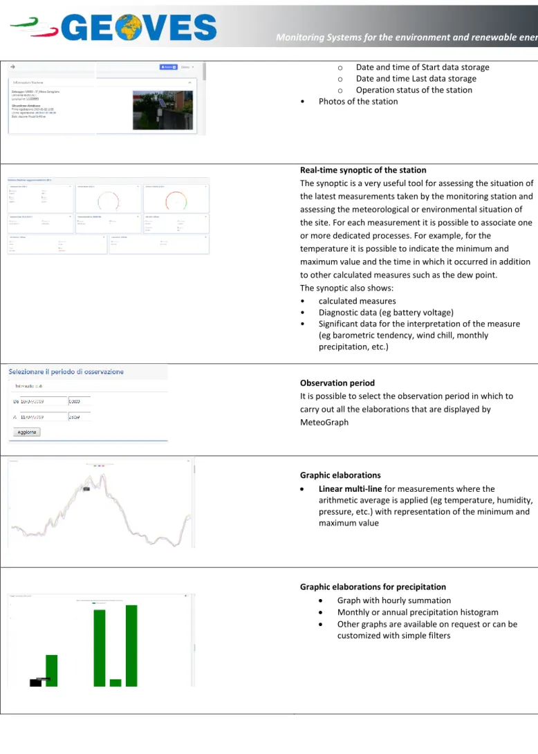
Station situation - Station information The parameters displayed are: • Station unique identifier (ID) • Name of the station
• Geographic coordinates (Latitude and Longitude) • Data base status:
pag.5/6 Geoves Snc
Via Magg.Piovesana, 155/a 31015 Conegliano (TV) - Italy C.F. e P.IVA: 04433390269
tel.: +39 0438 22099 fax: +39 0438 420668 E-mail: [email protected] http://www.geoves.it
G e o ve s m ig lio ra c o st a n te m e n te i p ro p ri p ro d o tti . P e rt a n to la p re se n te s p e ci fic a p u ò s u b ire v a ria zi o n i s e n za a lc u n o b b lig o d i p re a vv is o . T u tti i d iri tti s o n o r is e rv a ti p e rt a n to la d iv u lg a zi o n e d e l p re se n te d o cu m e n to è v ie ta ta G e o ve s co n st a n tly im p ro vi n g o u r p ro d u ct s. T h e re fo re , t h is s p e ci fic a tio n m a y b e c h a n g e d w ith o u t n o tic e . A ll rig h ts r e se rv e d s o th e d is cl o su re o f t h is d o cu m e n t i s p ro h ib ite d
o Date and time of Start data storage o Date and time Last data storage o Operation status of the station • Photos of the station
Real-time synoptic of the station
The synoptic is a very useful tool for assessing the situation of the latest measurements taken by the monitoring station and assessing the meteorological or environmental situation of the site. For each measurement it is possible to associate one or more dedicated processes. For example, for the
temperature it is possible to indicate the minimum and maximum value and the time in which it occurred in addition to other calculated measures such as the dew point. The synoptic also shows:
• calculated measures
• Diagnostic data (eg battery voltage)
• Significant data for the interpretation of the measure (eg barometric tendency, wind chill, monthly precipitation, etc.)
Observation period
It is possible to select the observation period in which to carry out all the elaborations that are displayed by MeteoGraph
Graphic elaborations
Linear multi-line for measurements where the
arithmetic average is applied (eg temperature, humidity, pressure, etc.) with representation of the minimum and maximum value
Graphic elaborations for precipitation Graph with hourly summation
Monthly or annual precipitation histogram Other graphs are available on request or can be
pag.6/6 Geoves Snc
Via Magg.Piovesana, 155/a 31015 Conegliano (TV) - Italy C.F. e P.IVA: 04433390269
tel.: +39 0438 22099 fax: +39 0438 420668 E-mail: [email protected] http://www.geoves.it
G e o ve s m ig lio ra c o st a n te m e n te i p ro p ri p ro d o tti . P e rt a n to la p re se n te s p e ci fic a p u ò s u b ire v a ria zi o n i s e n za a lc u n o b b lig o d i p re a vv is o . T u tti i d iri tti s o n o r is e rv a ti p e rt a n to la d iv u lg a zi o n e d e l p re se n te d o cu m e n to è v ie ta ta G e o ve s co n st a n tly im p ro vi n g o u r p ro d u ct s. T h e re fo re , t h is s p e ci fic a tio n m a y b e c h a n g e d w ith o u t n o tic e . A ll rig h ts r e se rv e d s o th e d is cl o su re o f t h is d o cu m e n t i s p ro h ib ite d Graphic elaborations
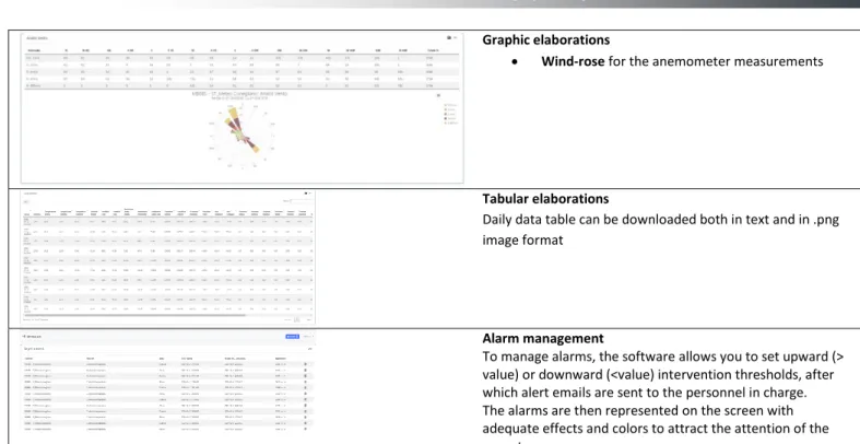
Wind-rose for the anemometer measurements
Tabular elaborations
Daily data table can be downloaded both in text and in .png image format
Alarm management
To manage alarms, the software allows you to set upward (> value) or downward (<value) intervention thresholds, after which alert emails are sent to the personnel in charge. The alarms are then represented on the screen with adequate effects and colors to attract the attention of the operator