REVIEWARTICLE
Spatial models for context-aware
indoor navigation systems:
A survey
Imad Afyouni, Cyril Ray, and Christophe Claramunt
Naval Academy Research Institute, Brest, FranceReceived: November 9, 2011; returned: January 19, 2012; revised: February 28, 2012; accepted: May 25, 2012.
Abstract: This paper surveys indoor spatial models developed for researchfields ranging from mobile robot mapping, to indoor location-based services (LBS), and most recently to context-aware navigation services applied to indoor environments. Over the past few years, several studies have evaluated the potential of spatial models for robot navigation and ubiquitous computing. In this paper we take a slightly different perspective, consid-ering not only the underlying properties of those spatial models, but also to which degree the notion of context can be taken into account when delivering services in indoor environ-ments. Some preliminary recommendations for the development of indoor spatial models are introduced from a context-aware perspective. A taxonomy of models is then presented and assessed with the aim of providing aflexible spatial data model for navigation pur-poses, and by taking into account the context dimensions.
Keywords: indoor spatial data models, context-awareness, navigation systems and
wayfinding, qualitative spatial representation, quantitative spatial representation, location-dependent queries
1 Introduction
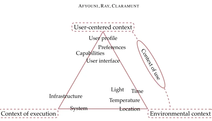
User-centered context
Context of execution Environmental context Temperature
Preferences
Time
Location Infrastructure
System Capabilities
User interface
Light User profile
Con tex
t o f use
Figure 1: A classification of context dimensions.
environment, as well as the interfaces to interact with. Two generic concepts have been in-troduced as superclasses that encapsulate contextual dimensions [99]. Figure 1 summarizes those context dimensions.
• Thecontext of useincludes: (1) user-centered dimensions of context such as the user profile, preferences, and physical/cognitive capability, and the user interface that provides direct interaction with the system (i.e., input data manipulation and out-put communication operations); and (2) the environmental context which refers to the parameters that influence the user (e.g., location, time, temperature, light).
• Thecontext of execution models the behavior of an information system and encom-passes: (1) the infrastructure dimension and the topological organization of the sys-tem components; and (2) the syssys-tem dimension that evaluates resource utilization (e.g., memory, processor, and network) of the system components and capabilities of the user’s mobile device(s).
An indoor space can be informally defined as a built environment where people usu-ally behave [85] (e.g., houses, commercial malls). Emerging and continuing advances in ubiquitous systems and localization techniques have brought novel opportunities to de-velop context-aware indoor navigation services. Diverse kinds of services can be provided by enabling real-time integration of context dimensions into the services delivered to the users. Examples of such services include, but are not limited to, human wayfinding and navigation in built environments, evacuation routes for people stuck in a building in case of an emergency, and real-time collaborative activities [10, 30]. Much work has been done on user modeling for developing systems that can adapt to the properties and dimensions of the user [50,53,68]. Other efforts have addressed the issue of information gathering from different kinds of deployed sensors [27]; and systems that support collaborative activities, such as healthcare activities in a pervasive hospital environment [10].
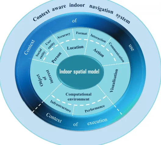
Computational environment
indoor
Computational environment
of
Indoor spatial model
Figure 2: Indoor spatial model to context-aware indoor system.
that contribute to the design of a context-aware system should be reflected by the spatial model underneath. Therefore, the integration of an indoor spatial model into a context-aware system implies a consideration of the environment as a dynamic system that should represent:
1. the features that populate the environment: a feature can refer to either aperson(i.e., mobile users and other social entities/human beings that are located in the vicinity and are of interest) or anobject of interest1.
2. their spatial properties, i.e.,locationsof the objects of interest and the spatial relation-ships that relate them.
3. theactionsthat emerge from them (i.e., physical interactions and communications). Moreover, specific properties of the spatial data model retained for the representation of an indoor space influence the manipulation, visualization, and computational capabilities of the system. Those characteristics will serve as basis for the development of our study.
This surveyfirstly discusses context-aware services and queries in indoor environments in order (1) to reconsider current indoor spatial models from a context-aware systems per-spective so that recommendations for the development of a reference spatial model can thereafter be proposed; (2) to take into consideration dynamic properties and
activity-1An object of interest (OOI) may be either communicating or not, mobile or static, physical or virtual, attractive
oriented interactions of moving objects with their physical surroundings; and (3) to ex-amine the role played by smart devices and ubiquitous positioning sensors.
The remainder of the paper is organized as follows. Section 2 provides a review of current location-dependent queries and services. Section 3 introduces a methodological framework for the design of indoor spatial models. Section 4 applies this framework to the assessment of current indoor spatial models. Variants of hybrid spatial models are discussed in Section 5. Finally, Section 6 concludes the paper and draws some perspectives.
2 Indoor location-aware navigation-related services
A wide range of location-aware services can be applied to indoor environments. The main goal of these services is to provide users with the ability to interact with their physical surroundings in order to achieve some objectives. Location-aware, user-centered services can be distinguished according to two modes of data access: pull mode and pushmode [109], which are defined as follows:
• Pull-based location-aware services comprise requests triggered by the user with the aim of pulling some location-dependent information from the service provider [55, 136].
• Conversely, push-based services are initiated by the service provider without having been requested by the user. The service provider takes into account location informa-tion of subscribed users to trigger alerts or contextual advertising, and push them to the user’s device [47, 96].
Location-dependent queries are typical examples of pull-based services needed in any context-aware navigation system [55, 136]. Queries are location-dependent, meaning that any change of the locations of objects that are involved in the query may significantly af-fect the answer. For example, if a user wants tofind friends within a range of 100m while navigating a shopping center, this answer will depend on the user’s current position as well as on the location of the nearest friends. Location-dependent queries have been sur-veyed in [55]; some particularly relevant queries in indoor contexts are briefly described as follows:
• Position queriesreturn the locations of mobile and static objects, and are processed according to either a geometric or a symbolic model of space. This is an essential kind of query since other location-dependent queries cannot be carried out without up-to-date information about the locations of objects of interest [13].
• Navigation queriesencompass all queries that directly help the users tofind and reach some points of interest by providing them with navigational information, while op-timizing some criteria such as total traversed distance or travel time. Examples of such queries are: (1) discoveringoptimalpaths to a nearest point of interest (e.g., a landmark or a place), (2) planning a path to a destination.
whether or not the query point is in a static location. Similarly, a range query can be applied on static or dynamic data, depending on whether target objects are moving or not.
• knearest neighbor (kNN) queriessearch for thekclosest qualifying objects to a moving user with respect to his or her current location [116,136]. As opposed to range queries,
kNN queries are range-independent, except in the case ofconstrained nearest neighbor
queries [42], where the search is constrained to a given region. The user triggers a request by specifying some properties of the objects of interest, so that thekclosest objects whose specifications meet these characteristics are retrieved (e.g., the closest available color printer or theknearest friends).
Efficient management of static and dynamic data is a key issue for processing these queries, since the result of a query is valid only for a particular location of the query issuer and the objects of interest. Therefore, continuously updating queries implies a communi-cation overhead and additional processing cost at the server side. A concept of validity region is introduced in [136] to lessen this problem by determining a safe area around the initial user position in which the result of the query is always valid. Many variants of these queries are summarized in [55]. Most work on location-dependent query processing has been developed with an outdoor environment in mind (cf. [55] for a recent survey). However, indoor environments bring some special features and constraints that should be considered during query processing (i.e., the constraints that emerge from the architectural layout of space). More realistic approaches based on network and/or temporal distances are generally preferred.
In particular, location-based alerts are not necessarily time-related and are generally used in the case of an emergency to warn people to avoid a dangerous zone. It might also be useful, for example, to remind a user navigating a shopping center to buy some groceries when he or she is located next to a supermarket. On the other hand, location-based advertisements [1] (also called proximity-triggered advertisements) generally target nearby consumers to provide them with information about stores’ offers, discount coupons, etc. These kinds of push-based services should provide users with a subscription-based mechanism that allows for relevant and non-intrusive advertising.
Although many research studies have discussed location-dependent queries and location-based services, a few works have addressed the issue of incorporating context dimensions into the query processing, particularly those related touser-centricand environ-mental contexts. These issues hare highlighted in [91], which discusses some of the chal-lenges to be considered in order to carry out context-aware queries and services. Some of these challenges include (1) designing a user model, (2) supporting multi-objective and possibly contradictory queries, and (3) analyzing efficiency and scalability when deal-ing with context-aware continuous queries. The followdeal-ing section discusses these issues and propose some preliminary recommendations for the development of an indoor spatial model that meets the requirements of such context-aware applications.
3 Requirements for context-dependent spatial models
Indoor spatial models have been studied and developed in many areas ranging from mo-bile robot mapping to GIS and ubiquitous computing [13, 94, 119]. This section classifies the requirements needed to design a context-dependent spatial model into two categories:
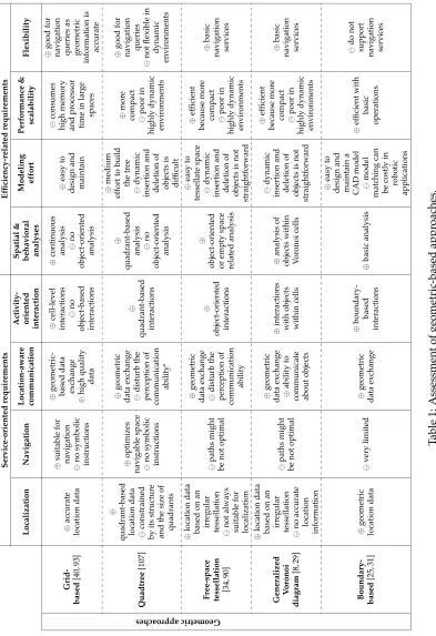
service-orientedandefficiency-relatedrequirements. Thefirst group supports real-time and delayed services, and includes: (1) localization, (2) navigation, (3) location-aware commu-nication, (4) activity-oriented interaction, and (5) simulation and behavioral analyses. The second group examines efficiency issues and includes: (1) modeling effort, (2)flexibility, and (3) performance and scalability. Those are generic and application-independent re-quirements for the development of a reference spatial data model, and are hereafter used to assess existing approaches.
3.1 Service-oriented requirements
A context-dependent spatial model should locate objects of interest appropriately and with additional semantic description so that advanced services can be provided. It also needs to support the navigational services of interest to a user. Potential communication between lo-cated entities should also be supplied. Moreover, users navigating an indoor space should be able to interact with their physical surroundings. Other deferred services can also be offered by the model, thus enabling a better understanding of users’ behaviors.
3.1.1 Localization
and topological levels; on the other hand, the task of achieving accurate localization is not always straightforward. Two different structures of location information can be delivered according to either a geometric or symbolic representation of space:
• Geometric informationgives a quantitative representation of moving objects in the form of coordinates (e.g., Cartesian or latitude, longitude, altitude) referenced to a given coordinate system. Whereas systems like Global Positioning System (GPS), used out-doors, provides geometric coordinates with respect to aglobal reference system, others such as the Active Bat system [127] and MIT Cricket [101] use ultrasonic technol-ogy and provide three-dimensional positions with respect tolocal coordinate systems. Those are developed based on a set of local landmarks (e.g., beacons) that are dis-tributed in an indoor space. Topological relationships like “overlap,” “inside,” “in-tersect,” and “disjoint” can be inferred, thus enabling an interpretation at a higher level of abstraction. As an example of overlapping relationships,floors can be shared between several wings within a building. In such a situation, floors overlap with wings, while a room may belong to afloor and a wing.
• Symbolic information provides qualitative human-readable descriptions about mov-ing objects based on structural entities and/or points of interest (e.g., room orfloor identifier, building name). For instance, the Active Badge system handles values that represent the symbolic identifiers offixed IR sensors [126]. In contrast to geometric information, symbolic descriptions allow topological relations (e.g., spatial contain-ment) between entities in the environment to be explicitly modeled. This can be done by means of symbolic spatial models such as set-based or graph-based models. Sym-bolic descriptions enable spatial and semantic reasoning at an abstract level, thus supporting interaction between spatial entities and within the indoor space.
Nowadays, techniques currently available forindoor positioningrange from radio-based technologies (WLAN, RFID, and Bluetooth) to non-radio technologies (infrared and ultra-sound) to inertial navigation systems (INS) [70]. Moreover, hybrid approaches appear to be promising solutions to providing reliable, continuous, and accurate location informa-tion [105]. These approaches highlight the fact that locainforma-tion informainforma-tion is often acquired by different sensor types. Therefore, appropriate multi-sensor data fusion techniques and map matching algorithms need to be used in thefiltering process [102]. Consequently, a spatial model should be capable of representing the coordinate system by which the loca-tion informaloca-tion is expressed and, when necessary, transforming that localoca-tion informaloca-tion in order to get all sensor data in a common format.
3.1.2 Context-aware, adaptive navigation
Navigation in the environment can be defined as a scheduled and goal-oriented movement made by humans or robots [92]. While navigating, a user may be technically assisted by sensory devices embedded in the environment that provide relevant information to main-tain orientation, and other suggestions to encourage the user to interact within the envi-ronment.
generates an unbroken path from the current location to the destination. This process is context-sensitive as it aggregates multiple criteria (e.g., user preferences and capabilities, distance, time) passed as function parameters to evaluate the cost value of each step and then to adopt the most appropriate path—that is, theoptimalpath that allows, for instance, to reach a destination while avoiding threats [36]. The dynamic phase lies in a dynamic framework that implements event-triggered controllers needed to monitor the user’s pro-gression in order to avoid deviations from the planned path. Although few works have discussed the integration of such a dynamic framework, researchers agree on some general requirements [33]. First, this framework should include a next-step selection algorithm that keeps continuous track of the user’s position and tries to recover from deviations by pro-viding additional information. Secondly, the framework should adapt the predetermined path if it detects any significant event that may affect the user’s movement. In such a sit-uation, a path to the nearest emergency exit should, for instance, be recomputed. Recent studies have proposed algorithms for shortest and/or fastest path searches with improved tracking strategies [18, 115, 132]. The main focus of these algorithms is to keep real-time tracking of moving objects. However, each of them deals with either time or distance con-straints without incorporating other elements such as user preferences or events that may significantly influence the answer.
3.1.3 Location-aware communication
In contrast to internet telecommunications, which enable communication between comput-ing devices based on IP or MAC addresses, communication among objects in smart envi-ronments is often based on their location [17]. Location-aware communication models in distributed systems can be classified according to who initiates information exchange and how information is then forwarded to the specified receiver [5]. One can make a distinc-tion between direct (i.e., point-to-point) and indirect communicadistinc-tions [9]. As an example of indirect communication, a provider can disseminate information about events to invoke
remote callback methodsfrom potential subscribers. Similarly, a consumer can request infor-mation from a known (i.e., direct message exchange) or anonymous (i.e., indirect message exchange) provider. Moreover, collaborative activities can take place between communi-cating objects working together to achieve some common goals.
Although spatial models do not affect users’ physical abilities to communicate, the adoption of a specific spatial model has a direct effect on the quality and format of data exchanged between users and other entities located in space. Moreover, the way a user perceives its ability to communicate with other entities may be significantly disturbed due to inadequate representation of space. For instance, afined-grained model can represent a sensor range more accurately than a coarse representation of space. Thus, the user can be aware of the exact communication range for a given sensor.
3.1.4 Activity-oriented interactions
A context-dependent model should also support human activities aimed at achieving some objectives. An activity can be defined as a collection of goal-oriented and context-dependent actions an entity can perform [69, 131]. Actions comprise a sequence of loca-tion movements, interacloca-tions with other neighboring entities and artifacts, and requests for some services in order to achieve a predefined goal. An activity can also be made of a set of primitive activities or be part of a larger collective activity [30]. Activity theory has focused attention on the usefulness of spatial models in the design process to enrich consciousness and interaction within space [65, 95].
Indeed, the number of artifacts has increased and been distributed into ubiquitous envi-ronments. Artifacts can be physical (e.g., chair, door, heating) or virtual (e.g., 2D/3D image of a physical artifact, digital user interface, recommendation/information) [98]. Physical artifacts can also be augmented with various kinds of sensors or tags (e.g., RFID) so that they can perceive the environment and provide additional information [106]. Those are referred to asdigitalorsentientartifacts [17, 66]. Spatial representations serve as a mediator to relay relevant information to humans about artifacts in their surrounding. This allows users engaged in a certain activity to both collect knowledge and understand their physical surroundings. Furthermore, it supports reconfiguring and manipulating physical/virtual artifacts to anticipate or produce changes in the environment. Consequently, embodied interaction, defined by [37], can take place by means of spatial reconfigurations that may influence the context by affecting existing activities and/or initiating new ones. A main challenge that designers face is to efficiently represent artifacts of interest located in the en-vironment. Unfortunately, most existing spatial models are not designed for that purpose and thus do not supply interaction with these artifacts and the tasks they might participate in.
3.1.5 Spatial and behavioral analyses
An essential issue in the development of analyses and simulations lies in identifying an appropriate spatial representation with respect to the phenomenon or behavior being ex-plored. Several typical scenarios for planning purposes are introduced in [86]. These sce-narios present application-dependent constraints, so each of them needs an appropriate level of granularity. Some examples of spatial analyses and scenarios applied on a fi ne-grained spatial model are [86]:
• Route analysis scenarios that aim tofind shortest paths between two given locations or all pairs shortest paths applied on a givenfloor architecture and with a given data structure [128, 137].
• Diffusion analysis defined as a dynamic process where the spatiotemporal evolution and extent of a phenomenon within an indoor space are explored [12].
• Centrality measures that characterize the architectural design and the spatial distri-bution of objects of interest in a built environment [20], and are largely applied by space syntax studies [60, 67, 71].
of the environment. In contrast, topological analyses often require a coarser granularity to support adjacency and connectivity relations between spatial units (e.g., room), and thus deriving a more abstract view of the topology of a complex indoor space. In particular, topological analyses have been largely developed and applied by space syntax studies to evaluate human-environment interactions and to examine different spatial and structural configurations [59, 122].
Behavioral analyses are, on the other hand, of special interest in context-aware com-puting, and have been recently developed in numerousfields for activity-recognition pur-poses [6]. Activity-recognition systems can support different application scenarios in many areas including safety control, medical healthcare, and other monitoring activities in virtual environments that aim to customize the system to end-users’ situations or contexts [10, 30]. This helps, for instance, to reduce the occurrence of hazardous situations by monitoring and correcting human error during the execution of critical tasks (e.g., administering medi-cation in healthcare, ensuring proper execution of tasks in safety applimedi-cations) or to exploit user interactions with an application (e.g., mouse clicks) to infer the user’s activities as sug-gested in [7]. Moreover, knowing the locations and preferences of the users in an indoor context-aware navigation system can lead to improving knowledge of the user’s behav-ior in the considered scenario (e.g., inferring the most bought products in a supermarket by loyal users) [100]. Activity monitoring combined with the delivery of behavior-related context-aware reminders for elderly persons have been also discussed in [137].
3.2 Ef
fi
ciency-related requirements
An offline requirement regarding the modeling effort needs to be considered in the evalu-ation process. A spatial model should also beflexible as much as possible so that a wide range of applications can be applied. Efficiency is closely related to the performance and scalability of the system being developed. Those requirements are discussed in the follow-ing subsections.
3.2.1 Modeling effort
The modeling effort can be evaluated by the cost and complexity of the model design effort. Some modeling techniques are sophisticated and take considerable effort [119]. Some oth-ers are closely dependent on objects within space and need to be periodically maintained or even to be rebuilt from scratch if these objects change their position or shape. Recently, some authors have discussed methods for automated construction that minimize manual intervention by designers during the modeling phase [114].
3.2.2 Flexibility
Conse-quently, we propose to assess current models based on the range of queries and services that can be supported.
3.2.3 Performance and scalability
A context-aware indoor navigation system must efficiently execute users’ queries, such as shortest paths between two given locations,knearest neighbors, or all accessible locations starting from their current positions [88]. Time complexity for query processing is given by the amount of CPU time spent per sampling unit. In addition, when considering contex-tual information, performance is no longer restricted to simply deriving position queries or distance functions, but some other features are required, thus leading to a significant increase in workload.
Furthermore, dynamic updates of the spatial data model stored on mobile devices should be periodically performed in order to maintain accuracy and quality of the stored data. For instance, one challenge facing spatial model designers is the cost of updating the location of every moving object continuously in the database. Existing approaches try to overcome this problem by performing periodic, deferred (i.e., demand-based) or imme-diate (i.e., event-driven) update queries to keep an incremental view maintenance of the database [56]. A related approach focuses on real-time map updates on mobile devices by considering the use of a spatial model with different levels of detail [64]. Updates in this approach are handled at the basic level on the server side, and then an update propagation process through the other levels of the spatial model is continuously performed at the client side.
The scalability requirement denotes the ability of a spatial model to scale up to a large indoor environment while keeping tolerable resource consumption, which mainly affects the memory storage capacity and the behavior of processing workloads. In context-aware applications, heterogeneous mobile devices as well as a huge number of embedded sensors have to be handled in an efficient and scalable way. Therefore, there is a need to establish a mechanism that eliminates superfluous information to reduce processing and communi-cation costs, so that the system can handle a higher number of real-time queries.
4 A taxonomy of indoor spatial models
In order to deliver navigation-oriented context-aware services applied to indoor spaces, the system requires an appropriate data model that is capable of representing the locations of objects either situated or active within the environment. Regarding modeling approaches, two main classes are inferred: symbolic and geometric spatial models. In the following section, the strengths and weaknesses of both classes of models are assessed by describing and evaluating different spatial representations.
4.1 Geometric-based approaches
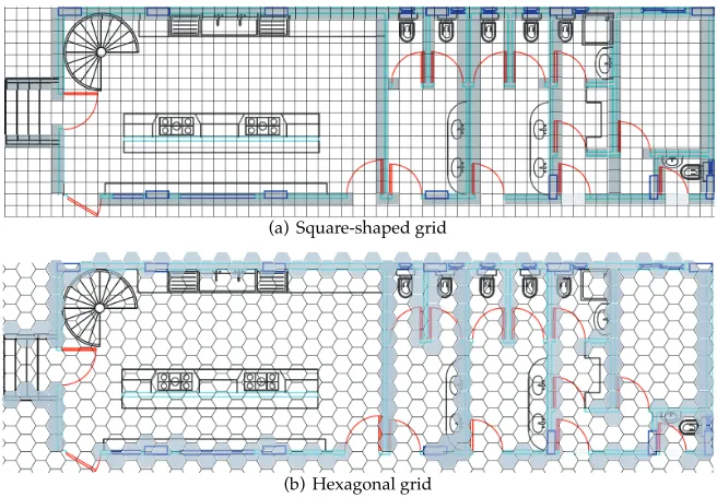
4.1.1 Cell-based models
The cell-based approach tessellates the physical space into a finite number of non-overlapping areas, thus building a partition that covers the entire space. This approach provides an implicit modeling ability to capture adjacency between neighboring cells. Two main types of tessellations can be distinguished [77, 90, 111]: regular tessellations decom-pose space into cells that have the exact same shape and size (e.g., primarily square- and hexagonal-shaped cells as illustrated in Figure 3). Irregular tessellations aim at providing an adaptive decomposition of space that is suitable to exactly represent the complexity of the environment being studied (e.g., to accurately represent obstacles). The cells forming the irregular partition of space can have different shapes and sizes (i.e., arbitrary polygons in 2D or polyhedrons in 3D).
(a) Square-shaped grid
(b) Hexagonal grid
Figure 3: Grid tessellation of afloor plan based on either (a) square or (b) hexagonal cells.
Regular tessellations A well-known regular tessellation is the grid-based model. Indeed, grid-based techniques are trivially implemented and can simply represent navigable and impassable regions in space by associating different cell states. In particular, the occupancy-gridapproach provides a probabilistic-based regular tessellation representation, which was firstly introduced in [40,93], to address mobile robot mapping issues. In an occupancy grid, a high probability value is assigned to cells within accessible space, while a low probability is assigned to cells occupied partially or completely by objects or obstacles.
on the cell resolution. Hence, afirst trade-off arises between the precision of information re-trieval and the consumption of limited computational resources, especially when dealing with large environments. A fine-grained grid provides accurate location data, but could introduce heavy processing workloads.
Dealing with a huge number of cells may exponentially increase query processing time (e.g., shortest path queries, real-time updates), thus leading to performance and scalabil-ity problems. Moreover, regular tessellation techniques do not precisely represent objects with arbitrary shapes. Hence, object boundaries are jagged, and it is possible for narrow pathways to be missed in the modeling process, especially in areas burdened by spatial objects.
The aforementioned inefficiency has motivated the development of hierarchically-organized grid-based structures known asquadtreesfor two-dimensional spaces [107]. For instance, the region quadtree(also referred to asPR quadtree) structure is commonly used when less detail is required for some paths of the represented space. This also allows missed pathways to be recovered by repeatedly creating smaller squares to capture more detail when necessary. However, the key disadvantage of this approach lies in its lack of flexibility, especially when dealing with a highly dynamic environment. Whenever the distribution of objects, such as moving users, sensors, and transient obstacles, changes, a significant update may affect the whole quadtree. Moreover, a quadtree model delivers quadrant-based location data so that accuracy is closely related to the size of the quadrant being identified. Localization in free areas, where the size of the quadrant can be exces-sively large, is therefore significantly disturbed and may not be sufficiently accurate for navigational purposes. A large quadrant representing a part of free space may also disturb the perception of communication ability of the user. A quadtree variant calledskip quadtree
is proposed in [41], which allows dynamic insertion and deletion of points, and search operations in logarithmic time.
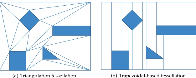
Irregular tessellations Given a set of polygonal obstacles described as line segments, two main techniques have been proposed to irregularly tessellate a space:
• free-space tessellationsthat take into account obstacles and decompose free areas into convex polygonal cells (e.g., triangles, trapezoids) [34, 90].
• Voronoi tessellationssubdivide space into a set of special cells calledVoronoi cells[8,29].
Free-space tessellations
Two kinds of decomposition can be described in this category:trapezoidal-and triangulation-basedtessellations. Both spatial models are constructed based on the endpoints of the line segments that compose the boundaries of the obstacles. Trapezoidal decomposition is built by projecting a vertical line from each end-point through the free space until it hits another barrier, thus forming trapezoidal cells of different thicknesses (Figure 4b). The resulting cells tend to be long and thick, which is not suitable for localization. Navigation is per-formed byfinding the intermediate cells that form a route to destination.
(a) Triangulation tessellation (b) Trapezoidal-based tessellation
Figure 4: Examples of free-space tessellation techniques.
of triangles that decompose space such that no endpoint is inside thecircumscribed circleof any triangle of the Delaunay triangulation.
Free-space tessellation methods support oriented analysis and allows for object-oriented interactions within space. However, they suffer from multiple paths between a source and a destination inside the chosen channel (i.e., the set of qualifying polygons), because accurate location information within each polygon cell is unavailable. Moreover, dynamic insertion and deletion of objects is rather difficult.
Voronoi tessellation
TheVoronoi diagram(VD) of a set ofkpoints is another approach that represents a built environment as a network of one-dimensional curves which concisely exhibit pathways across these points thus forming an irregular tessellation of space [8]. The VD can also be applied to convex objects such as line segments or obstacles rather than points. This extended approach, called thegeneralized Voronoi diagram(GVD), uses a function to mea-sure the distance from a point in space to the closest point on the geometric object (Figure 5). Choset et al. [28, 29] have formally discussed how to incrementally construct the GVD by operating with line-of-sight sensors so that they can derive ageneralized Voronoi graph
(GV G) used for motion planning as described in Section 4.2.
GVDs represent a fundamental data structure for spatial modeling and have been widely used in many research areas, such as robotic motion planning, computational ge-ometry, computer graphics, and GIS. As for other irregular tessellations, with a restricted number of objects Voronoi tessellations can be more compact than grid-based approaches. However, the construction and maintenance of GVDs is still not straightforward. Addition-ally, localization is often mentioned as a real problem since Voronoi diagrams force mobile users’ positions to be shifted along Voronoi edges which may yield to suboptimal trajec-tories. As a result, GVDs cannot directly fulfill our requirements with respect to context-aware navigational services, but lend themselves perfectly to extract the GVGs that, per se, can be used as operational route-based graphs suitable for many uses.
Serv ice-o riented requirements E f fi ciency -related requirements Localization N avigation Lo catio n-aware com m unication A ctivity-or ie n te d interaction Spatial & behav io ral analy ses M o
deling effo
rt Perfo rmance & scalability Flexibility Grid-based [40, 93 ] ⊕ accurate lo ca ti on d ata ⊕ suit able for navigat ion no symbolic in str ucti on s ⊕ ge ome tric-based d ata ex chang e ⊕ high q ualit y dat a ⊕ cell-level int eract ions no obje ct-ba se d int eract ions ⊕ cont inuous analy sis no obje ct-orie n te d analy sis ⊕ eas y to desig n and maint ain consumes high m emory and p ro ce ssor ti me in lar g e space s ⊕ good for navigat ion quer ies as ge ome tric informat ion is accurate Geom etrica pproaches Quadtree [107] ⊕ quadr ant -based lo ca ti on d ata const rained by it s str uctur e and the size of quadr ant s ⊕ op timiz es navigable space no symbolic in str ucti on s ⊕ ge ome tric dat a ex chang e dist urb the p er ce p tion of communicat ion abilit y a ⊕ quadr ant -based int eract ions ⊕ quadr ant -based analy sis no obje ct-orie n te d analy sis ⊕ medium ef fort to build th e tr ee dy namic insert ion and d ele tion of obje cts is dif fi cult ⊕ mor e
compact p
oor in highly dynamic env ir onment s ⊕ good for navigat ion quer ies not fl exible in dy namic env ir onment s F ree-space tessellation [34, 90 ] ⊕ lo ca ti on d ata based on an irr egular te sse ll ati on not always suit able for localizat ion pat h s m ight be not opt imal ⊕ ge ome tric dat a ex chang e dist urb the p er ce p tion of communicat ion abilit y ⊕ obje ct-orie n te d int eract ions ⊕ obje ct-orie n te d or empt y space re lat ed analysis ⊕ eas y to te sse llate space dy namic insert ion and d ele tion of obje cts is n ot st raight forwar d ⊕ ef fi cient because m or e
compact p
oor in highly dynamic env ir onment s ⊕ basic navigat ion se rvice s Generalized Vo ro n o i diag ram [8, 29] ⊕ lo ca ti on d ata based on an irr egular te sse ll ati on no accurate locat ion informa tion pat h s m ight be not opt imal ⊕ ge ome tric dat a ex chang e ⊕ abilit y to communicat e abo u t object s ⊕ int eract ions with objects wit hin cells ⊕ analy sis of object s w it hin V or onoi cells dy namic insert ion and d ele tion of obje cts is n ot st raight forwar d ⊕ ef fi cient because m or e
compact p
Figure 5: A generalized Voronoi diagram of an indoor space [124].
of these techniques do not support highly accurate localization of mobile objects within the polygonal cells.
4.1.2 Boundary-based models
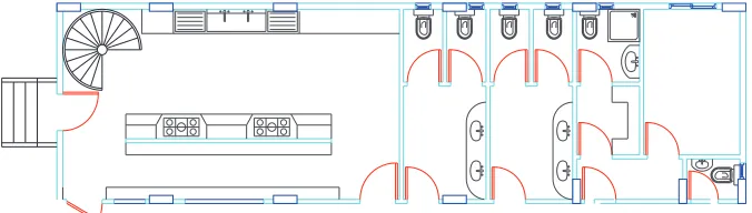
Boundary-based models represent the obstacles’ boundaries of an indoor space with se-quences of primitive geometries, such as points, lines, curves. In most cases, a boundary-based map is constructed by concatenating a set of lines segments either extracted from sensor data and representing obstacles as polygons [25, 31, 117], or designed using a CAD system (Figure 6). In many robotic applications that assume no prior knowledge of the environment, sensor data is obtained and the resulting extracted objects are matched to a geometric map. However, model matching can be computationally expensive [117]. In-deed, the line extraction sensors need to be extremely accurate so that lines representing walls, for instance, can be properly positioned at the right location and the right angle on the map. On the other hand, a geometricfloor plan can be designed using a CAD system so that various spatial entities (e.g., doors, windows, rooms) are represented as sequences primitive geometries.
Figure 6: Example of afloor plan designed using a CAD system.
4.2 Symbolic-based approaches
Symbolic approaches have frequently attempted to model indoor environments using topological-based structures [39, 54]; graphs by capturing the connectivity and reachabil-ity between spatial units [46, 58, 123]; and hierarchies [15, 29, 113]. The main advantage of these approaches is that object location is provided semantically using human-readable descriptions (e.g., room identifier), and topological relationships are also represented. De-pending on their nature, symbolic location models can revealcontainment,connectedness,
closeness, andoverlappingrelationships [39, 54, 58]. Using the containment relationship, for instance, one can derive a hierarchical structure of the indoor space in order to take into account application constraints and properties. The accuracy of location information in symbolic space depends on the level of abstraction of the indoor data model. For instance, a place-based symbolic model can provide location information at the structural-entity level. However, symbolic models are often unable to support a highly accurate indoor position-ing system, and are less suitable for determinposition-ing the Euclidean distances between spatial entities. Moreover, a symbolic model depends on the application domain and needs to be created and managed accordingly. Hence, managing a very large number of location symbols requires an important modeling effort.
Symbolic models are classified into two categories: set-based models and graph-based models. The set-based approach gathers object or place identifiers into sets and subsets; these are used to define spatial relations between elements of a set or, for instance, the in-tersection between two subsets. [13, 19]. These sets can be further hierarchically organized to form a tree- or lattice-based structure [39, 54, 84]. Graph-based approaches represent a space as a topological graph. Nodes in the graph symbolize predefined landmarks (e.g., place, gate, sensor range, object) extracted either manually or automatically from the en-vironment. Edges stand for the connections that make it possible to move through these landmarks [29, 103, 104, 128]. These two categories will be discussed further as follows.
4.2.1 Set-based symbolic models
ma-jor difference between these two approaches is the level of abstraction. Place-based mod-els deal with places and build a hierarchy based on the containment relationship; object-oriented models consider not only places, but all other objects of interest (e.g., walls, doors, sensors) in order to build the hierarchy.
Place-based sets Current place-based approaches model an indoor space by creating sets and subsets of place identifiers based on the architectural properties of space [39, 62]. A typical example considers places of a building such that eachfloor is contained within a building, and each room is contained within at most onefloor. A superset is likely to be defined as the set offloor numbers, and at a lower level, a subset related to eachfloor that aggregates all room numbers has to be created. Such a model is hierarchically organized and can be viewed as a tree structure in which location information is represented at differ-ent levels of abstraction. Moreover, when considering places and their neighbors, one can reflect adjacency relations between them as well as some qualitative notions of distance, i.e., one can infer that the distance between two neighboring rooms is smaller than the distance between two distant rooms [13].
Place-based sets models deliver room-level location data, and allow for place-based data exchange as well as for interactions with places. However, the main shortcoming of those approaches is their inability to model connectivity between places as, for instance, two neighboring rooms may or may not be interconnected. Also, it is often unable to de-termine quantitative distance efficiently. Furthermore, such a tree-based structure is built with respect to the containment relationship, and it does not allow for an element to inherit from multiple parents; this means that a place cannot be contained within two overlapping subsets. This is the case wherefloors are shared between several wings within a building. In such a situation, a room may belong to afloor and a wing at the same time. This problem has been dealt with by using a lattice structure instead of a conventional tree [83].
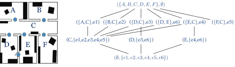
(a) An exit-location area in a building
({A, B, C, D, E, F},∅)
({A,C},e1) ({B,C},e2) ({D,C},e3) ({D, E},e6) ({E,C},e4) ({F,C},e5)
(C,{e1,e2,e3,e4,e5}) (D,{e3,e6}) (E,{e4,e6})
(∅,{e1, e2, e3, e4, e5, e6})
(b) The corresponding lattice-based model
Figure 7: Example of a place-based set model.
As defined in [62], afine-element lattice is a partially ordered set in which every subset can have a least upper bound and a greatest lower bound. These characteristics of lattices are then applied on a set of places along with the containment relationship≤(i.e.,p1≤p2
means p2 spatially containsp1) in order to construct the model. This model overcomes
Figure 8: Example of an object-oriented model of an indoor space.
However, this model does not lend itself to other tasks like navigation, because it still does not represent connectedness between places. Another lattice-based semantic model has been presented in [83], that uses the exit-location concept. The exit-location approach mod-els a given space with two types of entities: a location described as a bounded geometric area bordered by one or more exits, and an exit as a boundary gate that allows moving in or out of a location [54, 78]. The hierarchical structure of the lattice is mainly based on the containment relationship between locations (see Figure 7). This model is, for instance, applied tofind optimal paths based on nearest neighbor relations.
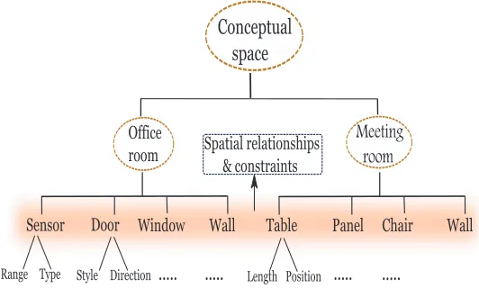
Object-oriented model An object-oriented model of an indoor space introduces an
ap-proach that annotates objects of interest with semantic information according to the prop-erties of the environment. Entities are thus represented as objects, and are characterized by specific attributes and relations. For instance, theIndustry Foundation Classes(IFC) provide a specification of an object-oriented data model, which serves as a data exchange format reflecting building information [48, 87]. In contrast to geometric plans (e.g., 2D or 3D CAD drawings), IFC represent all entities of space (e.g., walls, windows) as objects. IFC-based models are used in planning and management processes to improve quality of data ex-changed and to perform complex management-oriented analysis (e.g., electronic checking, energy effort)
An object-oriented model based on the IFC specification has been proposed in [19]. The indoor space is then defined as the combination of three complementary layers:
• A conceptual layer models terminological and functional characteristics on the archi-tectural entities (e.g., sensor, sliding door, meeting room, computer science labora-tory) regardless of how and where they will be used.
• A quality module gives qualitative descriptions about spatial dependencies and rela-tionships with other entities. For instance, the authors use relations as provided by the spatial calculus RCC [51] (e.g., proper part of, partially overlaps, and so forth)
The advantage of this approach is that it (spatially) qualifies the different roles played by the objects in the environment. Such a conceptual space, illustrated in Figure 8, models all entities of interest along with quantitative and qualitative properties attached to them, as well as spatial relationships and constraints between represented entities.
Object-oriented data models provide symbolic location data at the object level, and al-low for semantically-enriched data exchange about objects of interest. Moreover, object-oriented spatial and behavioral analyses can be performed. Nevertheless, object-object-oriented approaches are not directly suitable for navigational tasks, since geometric details about represented objects as well as connectivity and adjacency relationships are not directly sup-ported.
4.2.2 Graph-based models
Graph-based approaches represent an indoor space as a graph where nodes model prede-fined locations (e.g., place, gate, point of interest) extracted either manually or automat-ically from the environment, and edges stand for the connections that make it possible to move through these locations [29, 103, 104, 128]. For instance, a topological graph that directly reflects the architecture of afloor plan represents rooms as nodes and doorways as edges; this can simply express connectedness relationship between the architectural en-tities [46]. In this category, two main modeling concepts are discerned: layout-basedand
layout-independentmodels. The difference between these two categories is shown as fol-lows.
The layout-based representations rely on graphs where nodes are derived or extracted from the structure of space. This can be exhibited by a basic graph model that can be referred to as aplace graph, as well as byvisibility graphs.Voronoi-based graphsare also con-structed by extracting meet points and boundary points directly from space as described earlier. These points refer to the nodes of the generalized Voronoi graph.Fine-grained graphs
preserve indirectly structural properties of the environment since nodes are evenly dis-tributed over the entire space. In contrast, some other approaches have adopted graph models that are layout-independent [14, 58]. Nodes are then not directly derived from the structure, but instead are extracted by means of a sensor deployment strategy within space.
Place graphs
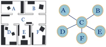
In their simplest form, place graphs clearly materialize topological properties of space. In this approach, nodes stand for places such as rooms and/or hallways, and doorways that connect these places appear as edges (Figure 9). Besides the connectivity relationship, other variants of topological relations between structural entities can be inferred, such as adjacency and containment properties by annotating nodes and edges and/or supporting a graph with multiple levels of granularity. So far, this modeling concept has been widely used since it provides for efficient navigation between places, planning routes to destina-tions, and nearest neighbor queries. In addition, it supports symbolic data exchange and interactions with places. Nevertheless, this approach still does not consider interacting ob-jects. It also has a less accurate location information that does not meet specific application requirements. Geometric properties of space disappear, and it is still difficult to model a semantic distance function which helps, for instance, determining the shortest path.
Figure 9: An place graph representing structural entities of an indoor space.
to integrate geometric information, such as a distance model, to overcome some of the aforementioned problems. The exit-location approach models the space with two types of entities: a location described as a bounded geometric area bordered by one or more exits, and an exit as a boundary gate that allows movement in or out of a location. The authors have introduced a series of algorithms for automatically constructing the location and exit hierarchies to derive the symbolic location model. Moreover, this symbolic model is built on some geometric information that maintains distance semantics to support services such as nearest neighbor search, shortest path, and location-aware navigation. Although this ap-proach has dealt with many critical problems, other advanced contextual queries were still not addressed because the model cannot fully support object movement and can provide only basic types of services.
Visibility graphs
Based on a triangulation, one can derive a visibility graph that materializes edges between mutually visible endpoints representing specific locations and obstacles [32]. Visibility graphs are useful for some behavioral and spatial analyses [46, 121]. However, the dis-advantages of triangulations remain; accuracy of location information, optimality of path queries, interaction, andflexibility are not dealt with. Furthermore, dynamic insertion and deletion of objects may lead to changes in the graph topology, i.e., the locations and number of nodes can change, and additional edges could be drawn.
Generalized Voronoi graph (GVG)
!!
"
#
Figure 10: Example of a sensor-based graph.
free-areas, which means that the model does not lend itself to completely support ubiqui-tous positioning sensors.
Fine-grained graphs
Although previous approaches consider an indoor space at a more abstract level and so have a more compact representation, they appear to be badly-suited to context-aware nav-igation services since interactions at afine level within space are increasingly needed. In a companion paper [86], the authors have presented a graph-based model at afine level of granularity that retains continuous and structural-based properties of space. Nodes in this model represent cells within an occupancy grid, while connections between cells are mate-rialized by edges (Figure 11). Nodes and edges are labeled according to their belonging to a given spatial unit, such as a room or a connecting space. One advantage of this model-ing approach is that it achieves a maximum coverage of space so that accurate positionmodel-ing sensors used for indoor navigation can be supported. Indeed, the geometrical properties are implicitly represented by the continuous layout of the graph and reflect indirectly the shapes of places being considered. This approach allows for high quality data exchange, and forfine-grained and continuous analysis. However, a major difficulty that still needs to be confronted is efficiency-related criteria, especially when considering performance and scalability issues. A large indoor space could comprise thousands of nodes and edges so that managing and executing real-time queries could be an excessive time- and memory-consuming process.
Sensor-based graphs
Figure 11: Example of afine-grained graph of afloor plan.
tioning sensors in indoor space into presence sensors and partitioning sensors can be found in [57]. Navigation between cells representing ranges of the deployed sensors is supported, which also allows for range-based analysis. However, accuracy of location information in such techniques is relatively low since it depends on the sensor range. Object-oriented interaction is also not supported since objects are not directly represented. Furthermore, an optimized deployment strategy of the sensors is needed so that a more compact and more efficient graph can be created. A more detail discussion on sensor-based graphs along with a method for an optimized deployment of sensors can be found in [63].
4.3 Discussion
A distinction is also made between spatial and semantic models since the latter kind of models is object-oriented and not necessarily spatially-dependent [129]. However, neither of these proposals has reviewed and assessed different modeling approaches from the par-ticular perspective of context-aware indoor navigation systems. A summary of different modeling approaches is given below, along with a discussion of their use from an applica-tion perspective.
4.3.1 Geometric-based approaches
Grid-based models can efficiently integrate metric properties, thus allowing precise lo-cations, direction information, and distances (cf. Table 1). Quadtrees are hierarchically-organized grid-based structures that allow for space optimization, but lackflexibility in dynamic environments. Free-space tessellations and Voronoi-based diagrams are less suit-able for localization, but they are more compact. Boundary-based models are less suitsuit-able for navigational services but provide accurate location data. In addition, geometric models require an integration of semantic annotations to achieve a higher degree of location- and context-awareness.
4.3.2 Symbolic approaches
As shown in Table 2, symbolic models are generally less accurate, but context-awareness is easier to achieve as symbolic models support human-recognizable descriptions. Owing to their hierarchical structure, set-based models achieve a good level of efficiency andfl ex-ibility, but lack topological relationships, such as connectedness. Graph-based models are widely used in applications at a coarse-grained level of abstraction due to their richness and variety. The major shortcoming of symbolic models is the lack of geometric details on entities and places represented in space.
4.3.3 Application perspective
5 Towards hybrid spatial models
Numerous spatial data models have been presented in different research fields (e.g., robotics, GIS, ubiquitous computing) with the aim of combining the advantages of geomet-ric and symbolic approaches [22, 61, 81, 118, 124]. Those approaches have complementary strengths and weaknesses. Geometric models can efficiently integrate metric properties to provide highly accurate location and distance information—necessary elements in most of context-aware applications. Symbolic models maintain a more abstract view of space by providing users with easily-recognizable information and by materializing more com-plex relationships between entities. Neither approach is, therefore, directly suitable for fulfilling all requirements of context-aware services. Clearly, integration of geometrical and topological representations implies considering qualitative and quantitative points of view, as suggested by the spatial semantic hierarchy (SSH) introduced in [73]. This enables human reasoning and human- or robot-centered activities, and even sensor-based interac-tions within the environment.
Accordingly, the idea of integrating different coexistent models of space appeared as a promising alternative. Hybrid spatial models can be produced in different manners by applying various kinds of organization [13, 22, 124]: (1) parallel models (also referred to as overlays) aim at using different spatial models (usually a combination of geometric and symbolic models) that cover the entire space [14, 86, 112, 118, 124]; (2) patchwork-based approaches represent a space with several local, usually geometrical, models that are linked together to form a global, usually symbolic, model of space [73]; and (3) hierarchical models that embed different layers with different levels of abstraction [43, 44, 61].
Recent studies on mobile robot navigation have focused on how to extract a topological graph from a basic geometric map, such as a grid-based map or a Voronoi diagram. The resulting graph is then pruned by applying some algorithms that select the more relevant nodes. This implicitly provides a hierarchical representation as those encompass knowl-edge of the environment at different levels of abstraction [118, 124]. Earlier, the SSH model has been presented [73, 74], and further extended in [16, 75]. The SSH model consists of a hierarchy of representations that are interdependent. This hierarchy is constructed from local geometrical maps that correspond to the human or robot’s sensory horizon, and are merged together based on topological relationships which, in turn, are derived from causal state-action-state schemata.
de-pending on users’ activities. The lattice model has been used together with a simple graph model, extracted to materialize connections, and to perform relevant location-dependent queries such as position, range, and path queries.
The annotated hierarchical graph model (AH-graph), presented in [43, 44], constitutes a comprehensive framework for efficient mobile navigation. The AH-graph consists of multiple topological layers defined at different levels of abstraction and linked together based on abstraction functions developed for nodes and arcs. An annotation function is also defined at each level so that information can be attached to nodes and arcs. This allows basic queries (e.g., path searching) to be performed hierarchically, thus achieving better scalability. An extension of the model was then presented by adding multiple hierarchies produced based on several scenarios specified at the application level, thus supporting a large spectrum of applications and achieving a high level offlexibility. The model has been further used in [103] to implement the SSH at the topological level due to its efficiency and flexibility. In [49], the AH-graph hierarchy was appended to a semantic hierarchy to further improve human-robot communication.
F loorExit01
e9
e6
e4
e1
e5 e2 e3
e7 e8
e10
e11 e12 e13 e14
F loorExit02
hierarchical link (parent-child) horizontal link (directly accessible)
Figure 12: Part of an exit hierarchy derived from afine-grained graph (Floor-01, Building-1 of Figure 11).
Generally, parallel models that combine, for instance, a graph-based model with a geo-metrical model underneath, tend not to scale well to large environments since they could not avoid the weaknesses of geometric models with respect to efficiency and scalability. Hierarchical models, by contrast, scale very well to large environments because queries, such as path search, are performed hierarchically, switching between finer and coarser levels. In addition, a specific level of granularity can be used in specific situations with respect to application constraints and users’ preferences. Approaches that integrate hierar-chical organization require, however, the maintenance of connections between levels and the integration of afine-grained geometric model that guarantees accurate localization for specific navigational purposes.
Stair01
HW03
HW02
MR01 HW01
R01
BT01
BT02 R17 R16
R15
HW04
R02 R03 BT01 R13 R14
Stair02
Figure 13: Part of a location hierarchy derived from afine-grained graph of Figure 11.
location-dependent query processing. Moreover, this model supports different categories of location-dependent queries, either in continuous or discrete modes, as well as algorithms for continuous processing of navigation and range queries [2]. Future work will be ori-ented towards (1) taking advantage of this proposal to deal with the continuous processing behind other relevant location-dependent queries in indoor contexts; (2) integrating an ex-tended context model with a semantic reasoning in real time, mainly to deal with real-time event management; and (3) generalizing the hierarchical data model to higher levels of abstraction (floor and building levels), thus building a nested-graph model similar to the hypernode/master-node data model described in [82] and [89], respectively.
6 Conclusion
con-tainment and connectedness relationships between entities, coupled with a fine-grained geometrical model can guaranteeflexibility, efficiency, and accuracy so that a large range of context-aware queries and services can be provided.
References
[1] AALTO, L., GOTHLIN, N., KORHONEN, J., AND OJALA, T. Bluetooth and WAP push based location-aware mobile advertising system. InProc. Second International Conference on Mobile Systems, Applications, and Services, MobiSYS(2004), ACM, pp. 49– 58. doi:10.1145/990064.990073.
[2] AFYOUNI, I., ILARRI, S., RAY, C.,ANDCLARAMUNT, C. Context-aware modelling of continuous location-dependent queries in indoor environments.Journal of Ambient Intelligence and Smart Environments(2012, accepted), 24pp.
[3] AFYOUNI, I., RAY, C., AND CLARAMUNT, C. A fine-grained context-dependent model for indoor spaces. InProc. 2nd ACM SIGSPATIAL International Workshop on Indoor Spatial Awareness(2010), ACM, pp. 33–38. doi:10.1145/1865885.1865894. [4] AFYOUNI, I., RAY, C., ILARRI, S., AND CLARAMUNT, C. Un mod`ele de donn´ees
pour les requˆetes sensibles au contexte dans les environnements “indoor”. InActes des Huiti`emes Journ´ees Francophones Mobilit´e et Ubiquit´e, UBIMOB(2012), C´epadu`es, pp. 1–11.
[5] AITENBICHLER, E. Event-based and publish/subscribe communication. InHandbook of Research on Ubiquitous Computing Technology for Real Time Enterprises. Information Science Publishing, 2008, pp. 152–171. doi:10.4018/978-1-59904-832-1.ch007.
[6] ALBINALI, F. Activity-aware computing: Modeling of human activity and behavior. PhD thesis, The University of Arizona - Department of Computer Science, 2008.
[7] ALBINALI, F., AND GNIADY, C. CPM: Context-aware power management in WLANs. In Proc. 18th Conference on Innovative Applications of Artificial Intelligence
(2006), vol. 2, AAAI Press, pp. 1745–1750.
[8] AURENHAMMER, F. Voronoi diagrams: A survey of a fundamental geometric data structure.ACM Computing Surveys 23, 3 (1991), 345–405. doi:10.1145/116873.116880. [9] BALDONI, R.,ANDVIRGILLITO, A. Distributed event routing in publish/subscribe communication systems: A survey. Tech. rep., Dipartimento di Informatica e Sis-temistica, Universita di Roma ”La Sapienza”, TR-1/06, 2005.
[10] BARDRAM, J. Activity-based computing: Support for mobility and collaboration in ubiquitous computing. Personal and Ubiquitous Computing 9, 5 (2005), 312–322. doi:10.1007/s00779-004-0335-2.
[12] BATTY, M., XIE, Y., AND SUN, Z. Modeling urban dynamics through GIS-based cellular automata. Computers, Environment and Urban Systems 23, 3 (1999), 205–233. doi:10.1016/S0198-9715(99)00015-0.
[13] BECKER, C.,ANDDURR, F. On location models for ubiquitous computing. Personal and Ubiquitous Computing 9, 1 (2005), 20–31. doi:10.1007/s00779-004-0270-2.
[14] BECKER, T., NAGEL, C., AND KOLBE, T. Supporting contexts for indoor naviga-tion using a multilayered space model. InProc. 10th International Conference on Mo-bile Data Management: Systems, Services, and Middleware (2009), IEEE, pp. 680–685. doi:10.1109/MDM.2009.116.
[15] BECKER, T., NAGEL, C.,ANDKOLBE, T. Discussion of Euclidean space and cellular space and proposal of an integrated indoor spatial data model. Tech. rep., Institute of Geodesy and Geoinformation Science, 2010.
[16] BEESON, P., JONG, N., AND KUIPERS, B. Towards autonomous topologi-cal place detection using the extended Voronoi graph. In Proc. IEEE Interna-tional Conference on Robotics and Automation, ICRA (2005), IEEE, pp. 4373–4379. doi:10.1109/ROBOT.2005.1570793.
[17] BEIGL, M., ZIMMER, T., AND DECKER, C. A location model for communicating and processing of context. Personal and Ubiquitous Computing 6, 5–6 (2002), 341–357. doi:10.1007/s007790200039.
[18] BERGER, A., GRIMMER, M.,ANDM ¨ULLER-HANNEMANN, M. Fully dynamic speed-up techniques for multi-criteria shortest path searches in time-dependent networks. InProc. 9th International Symposium on Experimental Algorithms (SEA). Springer, 2010, pp. 35–46. doi:10.1007/978-3-642-13193-6 4.
[19] BHATT, M., DYLLA, F.,ANDHOIS, J. Spatio-terminological inference for the design of ambient environments. InProc. 9th International Conference on Spatial Information Theory, COSIT(2009), Springer, pp. 371–391. doi:10.1007/978-3-642-03832-7 23. [20] BONACICH, P. Power and centrality: A family of measures. American Journal of
Sociology 92, 5 (1987), 1170–1182. doi:10.1086/228631.
[21] BURAK, A.,ANDSHARON, T. Usage patterns of friendzone: Mobile location-based community services. In Proc. Third International Conference on Mobile and Ubiquitous Multimedia(2004), ACM, pp. 93–100. doi:10.1145/1052380.1052394.
[22] BUSCHKA, P. An investigation of hybrid maps for mobile robots. PhD thesis, ¨Orebro Universitetsbibliotek, Sweden, 2005.
[23] CAGIGAS, D.,ANDABASCAL, J. Hierarchical path search with partial materialization of costs for a smart wheelchair. Journal of Intelligent and Robotic Systems 39, 4 (2004), 409–431. doi:10.1023/B:JINT.0000026090.00222.40.
[24] CHAMPANDARD, A. AI game development: Synthetic creatures with learning and reactive
[25] CHATILA, R.,AND LAUMOND, J. Position referencing and consistent world mod-eling for mobile robots. InProc. International Conference on Robotics and Automation
(1985), vol. 2, IEEE, pp. 138–145. doi:10.1109/ROBOT.1985.1087373.
[26] CHEN, G., AND KOTZ, D. A survey of context-aware mobile computing research. Tech. Rep. TR2000-381, Dartmouth College Hanover, NH, USA, 2000.
[27] CHEN, G., AND KOTZ, D. Context aggregation and dissemination in ubiquitous computing systems. InProc. Fourth IEEE Workshop on Mobile Computing Systems and Applications(2002), IEEE, pp. 105–114. doi:10.1109/MCSA.2002.1017490.
[28] CHOSET, H. Incremental construction of the generalized Voronoi diagram, the gen-eralized Voronoi graph, and the hierarchical gengen-eralized Voronoi graph. InProc. First CGC Workshop on Computational Geometry(1997).
[29] CHOSET, H., AND BURDICK, J. Sensor-based exploration: The hierarchical gener-alized Voronoi graph. International Journal of Robotics Research 19, 2 (2000), 96–125. doi:10.1177/02783640022066770.
[30] CHRISTENSEN, H., AND BARDRAM, J. Supporting human activities ex-ploring activity-centered computing. In Proc. Fourth International Confer-ence on Ubiquitous Computing, UbiComp (Berlin, 2002), Springer, pp. 107–116. doi:10.1007/3-540-45809-3 8.
[31] CROWLEY, J. World modeling and position estimation for a mobile robot using ultra-sonic ranging. InProc. IEEE International Conference on Robotics and Automation(1989), Computer Society Press, pp. 674–680. doi:10.1109/ROBOT.1989.100062.
[32] DEBERG, M., CHEONG, O., VANKREVELD, M.,ANDOVERMARS, M.Computational geometry: Algorithms and applications. Springer-Verlag, 2008.
[33] DELLING, D., SANDERS, P., SCHULTES, D., AND WAGNER, D. Engineering route planning algorithms. InAlgorithmics of Large and Complex Networks, Lecture Notes in Computer Science. Springer, 2009, pp. 117–139. doi:10.1007/978-3-642-02094-0 7.
[34] DEMYEN, D., ANDBURO, M. Efficient triangulation-based pathfinding. In
Proceed-ings of the 21st National Conference on Artificial Intelligence(2006), pp. 942–947.
[35] DEY, A.,ANDABOWD, G. Towards a better understanding of context and context-awareness. InProc. First International Symposium on Handheld and Ubiquitous Comput-ing (HUC)(Berlin, 1999), Springer. doi:10.1007/3-540-48157-5 29.
[36] DISSER, Y., M ¨ULLER-HANNEMANN, M., AND SCHNEE, M. Multi-criteria shortest paths in time-dependent train networks. InExperimental Algorithms, Lecture Notes in Computer Science. Springer, 2008, pp. 347–361. doi:10.1007/978-3-540-68552-4 26.
[37] DOURISH, P.Where the action is: The foundations of embodied interaction. The MIT Press, 2004.
![Figure 5: A generalized Voronoi diagram of an indoor space [124].](https://thumb-us.123doks.com/thumbv2/123dok_us/1157566.1617860/16.612.187.413.116.333/figure-generalized-voronoi-diagram-of-an-indoor-space.webp)
![CELLO: Understanding the responses of data to requests (CELLO : comprendre les réponses des données aux requêtes) [in French]](data:image/gif;base64,R0lGODlhAQABAIAAAP///wAAACH5BAEAAAAALAAAAAABAAEAAAICRAEAOw==)