Article
1
2
Transformative flood risk reduction in Jakarta: between urgent needs and
3
contested measures
4
5
Matthias Garschagen1*, Ayu Surtiari1, Mostapha Harb1
6
1 United Nations University – Institute for Environment and Human Security (UNU-EHS)
7
* Correspondence: [email protected]; Tel.: +49 228 815 0189
8
9
10
Abstract: Jakarta belongs to the cities with the highest flood risk in the world. Its flood hazard is
11
driven by land subsidence, soil sealing, changes in river discharge and increasingly sea level rise. As
12
all of these trends are set to continue, Jakarta’s flood hazard is expected to intensify in the future.
13
Designing and implementing risk reduction and adaption measures is therefore of utmost
14
importance. Against the background, the paper draws on a discourse analysis and original empirical
15
household survey data to review and evaluate current adaptation measures and to analyze in how
16
far they describe a path that is transformative from previous risk reduction approaches. The results
17
show that the focus is clearly on engineering solutions, foremost in the Giant Sea Wall project. The
18
project is likely to transform the city’s flood hydrology. However, it cements rather than transforms
19
the current risk management paradigm which gravitates around the goal of controlling flood
20
symptoms, rather than addressing their anthropogenic root causes. The results also show that the
21
planned measures are heavily contested due to concerns about ecological impacts, social costs,
22
distributional justice, public participation and long-term effectiveness. On the outlook, the results
23
therefore suggest that the more the flood hazard will intensify in the future, the deeper a societal
24
debate will be needed about the desired pathway in flood risk reduction and overall development
25
planning – particularly with regards to the accepted level of transformation, such as partial retreat
26
from the most flood-affected areas.
27
28
Keywords: transformation; flood risk reduction; Jakarta; risk governance
29
30
31
32
33
34
35
1. Introduction
36
Jakarta is amongst the coastal megacities with the highest flood risk globally (Hallegatte et al. 2013;
37
Hanson et al. 2011). Already today, it suffers from extreme flood events. In 2007, at least 56 died in
38
one of the worst floods in the city’s history, in which over 340,000 people had to be evacuated and
39
more than 74,000 houses were flooded (IFRC 2007). The economic damage of that flood alone, which
40
inundated around 60 percent of the city with flooding depths of up to four meters (IRFC 2007), were
41
estimated at around USD 560 million (Wijayanti et al. 2017). Yet, the 2007 flood was by no means a
42
one-off event. Heavy floods also happened, for instance, in the years 2013, 2014 and 2015.
43
Given the current magnitude and an expected future increase of Jakarta’s flood risk (see below), in
44
combination with the ineffectiveness of the existing risk management, radical changes in the city’s
45
risk reduction regime are necessary. This need calls for fundamental transformations not only in the
46
built environment and hydraulic infrastructure but also in institutional patterns of risk governance.
47
A first wave of transformational adaptation has been conceived. They are primarily focused on heavy
48
engineering solutions to regulate Jakarta’s flood hydrology, leading to substantial resettlement and
49
other – expected or already manifested -- social and ecological side effects. These solutions are
50
therefore heavily contested on the grounds of longer-term sustainability concerns.
51
Against this setting, Jakarta can be considered a highly relevant case study for the analysis of
52
transformational risk reduction, particularly regarding its enablers and barriers. Whilst conceptual
53
contributions to the debate around transformation have been on the rise over the past years (e.g.
54
Pelling 2011; O’Brien 2012; Pelling et al. 2015), the empirical understanding of how transformation is
55
debated in real-world cases and how it occurs – or not – is still thin (Solecki et al. 2017). The paper
56
aims at making a contribution to tackling this gap.
57
The next section provides a brief overview over the materials and methods used in this paper. Section
58
3 then reviews the existing conceptual discourse around transformation in the context of global
59
change research in order to identify key gaps and guiding questions for the Jakarta case study. Section
60
4 examines the causes for and trends in Jakarta’s flood risk – past, present and future. Section 5
61
introduces the main flood risk adaptation measures currently planned or implemented in Jakarta.
62
Section 6 evaluates the most important measures. Section 7 discusses the results. The last section
63
provides key conclusions and an outlook into future needs for science, policy and action.
64
65
2. Materials and methods
66
The analysis draws on different types of data and methods. Section 3 draws on academic literature
67
to review and assess the current debate with regards to transformation in the context of climate
68
change adaptation and risk reduction. Section 4 draws on existing studies and own analysis of
69
statistical as well as time-series remote sensing data to review and analyze the main drivers of
70
Jakarta’s flood risk and their trends. Section 5 draws on a document analysis to introduce the main
71
adaptation measures currently planned or implemented. Section 6 uses published literature and a
72
number of newspaper reports to conduct a brief discourse analysis on the evaluation of the main
73
adaptation measures introduced in section 5. In addition, section 6 draws heavily on own empirical
74
survey data to complement the adaptation evaluation, especially with regards to the social and
75
in 2014 and 2016, covering 451 households in 2014, out of which 410 have been re-interviewed in 2016
77
to assess changes over time. The households covered three main groups: First, households being
78
affected by reservoir dredging projects; second, households affected by dyke construction; third,
79
households that have been resettled.
80
81
3. Transformation in the context of disaster risk reduction and adaptation
82
Over the past five years, the notion of transformation has gained considerable traction in science and
83
policy debates around global environmental change (O’Brien 2012). The transformation debate to a
84
large extent originates from climate change mitigation debates. It has been used there to refer to the
85
need for fundamental shifts of the economy, away from its heavy dependence on fossil fuels and
86
other resources such as land and water (WBGU 2011). However, more recently the need for
87
fundamental system shifts are also seen in the realm of climate change adaptation and risk mitigation.
88
One of the main arguments of this debate is that current modes of risk management will increasingly
89
reach their limits in view of future risk trends, which result from the intersecting drivers of climate
90
change and risk-prone socio-economic developments (e.g. urbanization in coasts with high exposure
91
to natural hazards) (Pelling 2011; Solecki et al. 2017; Few et al. 2017; Thomalla et al. 2018).
92
Transformation proponents in this line of thinking argue that the recent surge in the use of resilience
93
concepts can be counterproductive in this context. This is because resilience debates, so the argument
94
goes, tend to concentrate on the persistence and strengths of existing systems and their
95
configurations, whilst sustainable risk reduction is argued to necessitate deep changes of system
96
configurations in many respects (Pelling 2011). A growing body of literature therefore raises concerns
97
that many political and practical initiatives for risk reduction and resilience building concentrate on
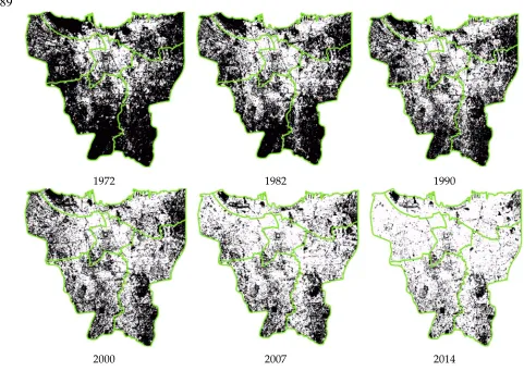
98
tackling superficial risk symptoms (e.g. by slum upgrading projects), rather than the deeper
99
institutional root causes of vulnerability and risk (e.g. the political economies that lead to the
100
production and reproduction of marginalization and vulnerability in the first place). Current risk
101
reduction and adaptation efforts therefore have been critiqued to be not sustainable – or even
102
palliative (Ribot 2011). Following this line of thinking, lasting and sustainable risk reduction therefore
103
requires the fundamental transformation of the political economy behind the very production of risk
104
and vulnerability.
105
Drawing on the context of costal megacities, Solecki et al. (2017), building on Pelling (2011) and
106
Pelling et al. (2015), therefore differentiate between different risk management regimes along a
107
gradient from collapse to resistance, resilience and transformation. The resistance regime is
108
characterized by actors and institutions geared towards keeping the current system and its
109
configurations (e.g. urban morphology) stable, despite increasing external stress, e.g. a rising
110
frequency and intensity of flooding. It implies rising input resources; for instance, protecting the
111
infrastructure and strengthening rigid institutional or bio-physical structures. Resistance often
112
involves conventional engineered solutions with a focus on the built infrastructure, e.g. coastal
113
defense systems – which is of high relevance to the Jakarta context. Resilience entails slight
114
adjustments of the current system to improve its ability to deal with external stress. However, the
115
an “adjustment at the margins,” which ultimately has the aim of stabilizing the core fabric of the
117
system in the face of potential external disturbance. In contrast, transformation is viewed as a form
118
of adaptation that fundamentally questions the setup and fit of current system configurations. The
119
aim of transformative adaptation is to find alternative ways of system configurations that increase
120
the system’s long-term sustainability through minimizing risk or rigidity traps, and through
121
establishing co-benefits from new development trajectories. Pelling (2011) argues that a
122
transformation, i.e. the fundamental reconsideration of human-environment relations, will become
123
increasingly necessary in view of growing levels of environmental hazards, stress and perturbation
124
with climate change. He argues that the current focus on resilience-building is therefore insufficient
125
as it does not engage with the necessary yet politically uncomfortable questions of radical changes,
126
e.g. with regards to land use policies, risk insurance configurations or the overall social contract for
127
risk reduction and social protection. By focusing too strongly on the maintenance of current system
128
configurations, resilience-oriented paradigms are therefore argued to run the risk of becoming
129
unattainable in the mid- to long-term future, thus propelling the need for all the more radical
130
adaptation into the future, yet at the expense of increasingly limiting the space for planned adaptation
131
choices. Collapse then refers to the most severe outcome if no adaptation or mal-adaptation is taken,
132
leading to a situation in which the hazard level renders sustaining the system as impossible (Solecki
133
et al. 2017).
134
135
A risk management regime is in this line of thinking understood to be describe “an assemblage of
136
policies, strategies, and regulations that collectively define a dominant paradigmatic management
137
approach can be observed in any moment within a city, and that these regimes are a product of
138
climate risk and urban development pressures and in turn will mediate their interaction” (Solecki et
139
al. 2017). Risk management regimes are therefore characterized by the deliberate and conscious as
140
well as non-deliberate ways in which risk is managed. Often, formerly deliberate policy choices and
141
paradigms become deeply entrenched institutionally or culturally, until they are no longer
142
deliberately reflected but rather enacted “automatically”.
143
Solecki et al. (2017) are particularly interested in the transitions between different risk management
144
regimes, i.e. the factors that enable or hinder actors and institutions in a given context to shift from
145
one to the other regime. In this context, they emphasize that shifts towards transformation or other
146
regimes can happen in single systems (e.g. on sector such as transportation) whilst other
sub-147
system remain in other regimes. They can also happen at different scales, e.g. where city governments
148
engage in changing their risk management regime in directions contrasting national policy.
149
Switches between the different regimes might also be related to turning points in adaptation
150
pathways (Haasnoot et al. 2013; Wise et al. 2014). Protective infrastructure such as a dyke system
151
might, for instance, work until a certain threshold to advance a rigid resistance level. Yet, after the
152
threshold has been reached, the costs of retrofitting might become so high that fundamentally
153
different alternatives might be sought, e.g. retreat from formerly protected areas. Hence, a
154
156
Yet, apart from conceptual considerations, empirical observations on different types of risk
157
management regimes and the transitions between them remain rather thin, especially with respect to
158
question how changes risk management regimes are contingent on changes in overall development
159
policy (Thomalla et al. 2018). The case study of Jakarta, one of the most flood prone cities globally
160
with extreme adaptation pressure to change current development trajectories, is therefore a prime
161
example for such type of empirical analysis.
162
163
164
165
4. Jakarta’s flood risk: causes and trends
166
Jakarta’s flood risk results from a number of intersecting drivers. First, there is the general
167
topography of the city. Due to the historically good conditions for trade and agriculture, the city
168
developed in the bay of Jakarta, into which the Chiliwung river and 12 other, smaller rivers flow,
169
crossing today’s city. Particularly the northern, coastal parts of the city are therefore characterized by
170
a very low-lying topography. Occasional flooding has therefore been an issue since the very early
171
times of today’s Jakarta, i.e. the harbor city Sunda Kelapa in the hinduistic Sunda kingdom and the
172
later Batavia, the headquarters of the Dutch East India Company from 1619 onwards (Ward et al.
173
2013).
174
However, the flooding problem has been greatly intensifying over the recent decades, mostly due to
175
anthropogenic drivers. First, the city has been experiencing a massive growth in population and
176
economic as well as industrial activity since the second half of the 20th century. Being the capital of
177
Indonesia and its clear center for economic, political and cultural activities (especially during the
178
centralistic Suharto regime) Jakarta’s population has grown to well over 10 million today, from
179
around 3 million at the early 1960s. (BPS 2015). Along with this growth, the city has been experiencing
180
an extensive spatial expansion. Figure 1 illustrates this expansion from 1972 to 2014, based on the
181
assessment of remote-sensing time-series data (6 Landsat scenes) through a supervised classification
182
approach, particularly drawing on the maximum likelihood algorithm of the Semi-Automatic
183
Classification Plugin (SCP) for QGIS.
184
The analysis shows that urban land use within Jakarta’s administrative boundary has increased by
185
276 percent over the last 4 decades, consuming 565 km² of the 674 km² available space, i.e. over 83
186
percent (Figure 2).
187
189
1972 1982 1990
2000 2007 2014
Figure 1: Maps illustrating the urban expansion in Jakarta from 1972 until 2014
190
191
Figure 2: Graph showing the rapid increase of the land consumption in Jakarta administrative
boundary from 1972 until 2014
192
193
205
286 322
394
477
565
0 200 400 600
1972 1982 1990 2000 2007 2014
UR
B
A
N
A
R
EA
(
K
M
²)
TIME (YEARS)
Area(Km²)
674 km²
Along with this increase, the city quickly sprawled beyond its original administrative boundaries,
194
forming an increasingly continuous mega-metropolitan area with formerly separated sub-centers in
195
neighboring regencies (Kapupaten). The mega-metropolitan region has been coined Jabodetabek, in
196
reference to Jakarta’s neighbors Bogor, Depok, Tangerang and Bekasi. At the latest census in 2010,
197
this region hosted 27 million people. Also here, a massive land use conversion has been taking place:
198
The built-up are in the Jabodetabek region grew from 65 to 2,015 km² between 1972 and 2012, i.e. by
199
a factor of 31 (Rustiadi et al. 2015).
200
Along with these massive land conversions in Jakarta and the entire Jabodetabek region, a high
201
number of rivers, canals and wetlands have been built-over, in effect massively reducing flood
202
retention and discharge capacities of the entire region.
203
The second important factor contributing to Jakarta’s flooding problem is the city’s significant land
204
subsidence. The rates of subsidence vary across time and space. But some parts of the city have been
205
experiencing rates of up to 25cm per year in extreme periods (Abidin et al. 2015). Long-term
206
measurements reveal that some parts of the city were sinking by a total of up to 4 meters between
207
1974 and 2010 (ibid.). The most affected areas are largely located within the coastal fringe in the north
208
of the city, i.e. the area anyhow featuring the lowest topography but also some of the highest
209
industrial activity.
210
Subsidence is driven by three main factors: (1) massive – mostly uncontrolled – groundwater
211
extraction for private and industrial purposes, (2) the natural sediment compaction which is not
212
compensated for due to the lack interruption of natural sedimentation replenishment, and (3) the
213
substantial compaction loads from buildings and other infrastructure (Budiyono et al. 2016). The
214
detailed quantification of these factors’ contribution is difficult and a field for further investigation.
215
Nevertheless, most studies agree that the groundwater extraction is by far the most important driver
216
for the observed subsidence.
217
A third factor contributing to Jakarta’s flood risk is the fact that many of the rivers and drainage
218
canals are poorly maintained and clogged with waste and sediments (Budiyono et al. 2016).
219
220
On top of existing flooding problems, the city might quite likely experience a further increase in flood
221
risk in the future, as the result of (1) continued growth and land conversion, (2) continued land
222
subsidence, (3) an increase in sea level due to climate change, and (4) an increase in the intensity and
223
frequency of storm and heavy precipitation events. Assuming a business-as-usual progression in sea
224
level rise, subsidence and population growth, modeling suggests that, in the absence of adaptation,
225
the population exposed to a 100-year return period extreme flooding event would rise by 350 percent
226
by 2070, to then over 2.2 million (Hanson et al. 2011).
227
228
229
230
5. Risk reduction and adaptation measures
231
Given Jakarta’s high current and future flood risk, there question of options for risk reduction and
232
adaptation is pressing. Yet, despite the recent surge in flood risk, this question is not new. Particularly
233
under Dutch colonial rule, the city has seen some quite sophisticated flood protection measures. Soon
234
1619, the Dutch started to implement structured canal system in the city, similar to ones in Dutch
236
cities of the time (Caljouw et al. 2005). In addition, a major canal, the so-called Western Canal, was
237
put into service in 1725 to divert parts of the Chiliwung’s discharge around the city. This type of
238
infrastructure-based diversions were further intensified in the following years, in an attempt to gain
239
ever more control over the city’s hydrology. Integrating these measures into an overarching and
240
comprehensive plan for the entire city, the so-called van-Breens-Plan, named after the project’s
241
leading engineer, was issued in 1917, in response to a devastating flood event. This plan comprised
242
major structural measures, including additional diversion canals in the city’s west (Western Banjir)
243
and east (Eastern Banjir). The plan’s strong focus on engineering solutions provided the major
244
paradigm for other plans to follow over the next decades, notably in 1965, 1973 and 1984 (Caljouw et
245
al. 2005; Ward et al. 2013).
246
Despite this long tradition in flood protection measures for the city, the extreme event of 2007 lead to
247
a significant intensification of the debate around flood risk reduction and a substantial
248
reconsideration of the respective toolbox – not only in Jakarta but in Indonesia at large (Djalante et
249
al. 2017). This reconsideration has been triggered by the new flooding context, which manifested itself
250
during the 2007 flood. The extreme flood levels of that year had been caused by the confluence of
251
heavy precipitation and discharge with a particularly strong spring tides. Hence, water was pushed
252
into the city not only by the rivers from the south, but also from the sea. This rather new situation
253
shifted the emphasis of flood protection quite drastically: The focus had hitherto been on diverting
254
the discharge of the upstream Ciliwung catchment area around the city and into the sea, the focus
255
now shifted to also include coastal protection, alongside with attempts to expand the retention
256
capacities within the city. As a result, the Jakarta Coastal Defense Strategy (JCDS) was conceived
257
under the patronage of the then governor Fauzi Bowo. The strategy got completed and formerly
258
adopted in 2011.
259
Since that time, flood risk reduction has been comprising three main groups of measures: First, a
260
strong emphasis has been on the river and canal regulation, the broadening of water ways and the
261
clearance of river banks, which are frequently encroached by informal settlers (Figure 3a). Second,
262
attention has been given to the refurbishment and expansion of flood reservoirs, especially in the
263
city’s northern parts (Figure 3b). Third, a major flood protection dam has been under construction
264
along the coast (Figure 3c).
265
As all of these measures need space, a significant amount of resettlement has been necessary over the
266
past years (Figure 3d). The vast majority of affected dwellings belong to low-income households
267
which had been settling informally on the banks of rivers and reservoirs, given their lacking financial
268
and institutional capital to access land in other parts of the city. The regulation of the Ciliwung alone
269
triggered the resettlement of 15,000 people, i.e. 4,000 households, over the last five years.
270
Figure 3: Pictures showing an encroached river bank (a); the widening of reservoir (b); the
272
construction of a new sea wall (c) and resettlement housing (d)
273
274
The Jakarta Coastal Defense Strategy has been continuously revised and expanded since 2011, leading
275
to the so-called National Capital Integrated Coastal Development Masterplan (NCICD) in 2014
276
(CMEA 2014). At its core, the plan builds on the idea to block the bay of Jakarta off from the sea, by
277
means of a so-called Giant Sea Wall. The project is also known as the “Great Garuda Project” as the
278
project’s aerial view resembles the shape of a Garuda, the national bird of Indonesia (see Figure 4).
279
The project has been conceived by a consortium of Dutch and Indonesian planning consultancies,
280
sponsored to a large extend by the Dutch government. Its planned engineering dimensions are quite
281
enormous: The planned sea dyke has a total length of 25 km. Behind it, the former bay shall be
282
converted into a sealed reservoir, the water table of which ought to be regulated so as to remain below
283
sea level in the future, thus allowing for the controlled flood drainage of the city. To achieve this, the
284
largest pumping station installation ever built in one project is planned at a capacity of 730 cubic
285
meters per second in order to pump the water from the reservoir out into the sea (CMEA 2014). In
286
addition, the plan includes upgrades and expansions to the existing flood protection infrastructures
287
in the city, foremost the retention reservoirs, drainage canals, flood protection walls as the main
288
In order to finance these measures, the plan envisages to combine flood protection with the
290
development of new estates for commercial and residential purposes. Within the reservoir massive
291
land reclamation projects are planned to provide space for a new central business district (CBD) and
292
residential area. Together with upgrading planned for the existing parts of northern Jakarta, the plan
293
foresees to generate residences for an additional 650,000 people and attract businesses with 350,000
294
new jobs (CMEA 2014). In addition, a new harbor and airport are planned toward the east of the
295
embanked area. The total costs of the project are estimated at around 40 billion USD (Win 2017). The
296
implementation is planned to span across three phases with the completion of the sea dyke being
297
targeted for 2022 (CMEA 2014).
298
299
300
Figure 4: Map of the Great Garuda project (Source: www.arbitare.it )
301
302
303
Next to these formal adaptation measures, flood-affected communities and households in Jakarta
304
heavily engage in small-scale and informal adaptation measures (Marfai et al. 2015; von Voorst 2016;
305
Surtiari et al. 2017). These include individual as well as collective measures, e.g. raising the housing
306
levels, building terraced housing or constructing small-scale water barriers around settlements.
307
However, empirical analysis has shown that these measures are limited in effectiveness to combat
308
the larger floods and their trend towards intensification. The need for more effective, larger-scale
309
flood risk reduction measures governed by formal actors has therefore been stressed (Marfai et al.
310
2015). Hence, the focus of this paper is clearly on formal measures – yet not devaluing the important
311
role of informal small-scale adaptation and the role it can, in accumulation, play for regime shifts at
312
the larger policy level.
313
317
6. Evaluating current adaptation measures
318
Given the profound – and potentially transformative – nature of the conceived adaptation measures,
319
questions regarding their evaluation are pressing, spanning across social, economic, ecological and
320
cultural dimensions. Many, if not most, of the currently planned or implemented adaptation
321
measures are greatly contested and have caused heated debates on Jakarta and beyond. Conflict has
322
lately erupted in particular over the Great Garuda project. A major concern, especially of Jakarta’s
323
coastal population, is that the embankment is expected to lead to substantial environmental
324
degradation in the bay of Jakarta, thereby causing great damage to local fisheries which provides a
325
major income source for coastal fishing communities. Such worries are backed, for instance, by a
326
study of the Maritime Affairs and Fisheries Ministry, published in 2015. First, the study cautions that
327
the massive embankment through the sea dyke is likely to trap polluted water discharged from the
328
city and its hinterland, hence, contributing to the contamination and, ultimately, eutrophication of
329
the new reservoir (Elyda 2015). Second, the reservoir is expected to trap sediment, hence, leading to
330
a fast sedimentation of the sea bed (ibid.). Third, the new reclamations require considerable amounts
331
of sand -- altogether around 300 million cubic meters (CMEA 2014) – which needs to be pumped
332
largely from the local sea bed. All of the above three effects are expected to have massive impacts on
333
the local ecology and fish stocks, causing ripple-on problems for local fishing communities whose
334
livelihoods depend on them (Elyda 2015). In addition, the sea dyke is expected to even alter local
335
currents to an extent that will cause the erosion of entire islands currently neighboring the planned
336
reservoir (Elyda 2015).
337
All these concerns have been taken up in fierce political debates. For instance, the promise to stop the
338
project had been a central element of election campaign of Anies Baswedan, the new governor of
339
Jakarta since October 2017. Already in 2016, a moratorium had temporarily stopped the project on
340
the basis of environmental concerns and corruption allegations. However, the moratorium has
341
recently been repealed by the national government, underscoring that conflicts exist not only between
342
different interest groups but also between different levels of government. The future is therefore
343
likely to see conflicts over the issue to continue.
344
Moreover, criticism is mounting with regards to the perceived social injustice in terms of how the
345
costs and benefits of the project are shared. While the expected benefits of the Great Garuda project,
346
such as the newly developed apartments or the planned business district, will mainly be geared
347
towards middle and upper income groups, the environmental, economic and social costs are largely
348
borne by lower income groups. Overall, our survey data reveals that almost all households which
349
have been directly affected by infrastructure measures (e.g. the coastal protection dyke or reservoir
350
widening) or even needed to be resettled reported a loss of household income. The loss has been most
351
drastic amongst former fishing households who needed to be resettled inland and now have to rely
352
on sporadic and informal income generation.
353
The repeated survey panels (in 2014 and then 2016 in the same households) also showed the many
354
early hopes in the adaptation measures did not hold the test of reality. Most importantly, while a
355
considerable amount of households expected the adaptation measures to lead to an increase in the
356
self-capacity to deal with future flood hazards, this expectation did not confirm in the second panel.
357
perceived decline in social cohesion after the implementation of the adaptation measure, particularly
359
in the case of resettlement. Figure 5 illustrates the decline in perceived mutual assistance at the
360
neighborhood level across all three major types of measures.
361
362
363
364
365
Figure 5: Perceived change in mutual assistance within the neighborhood
366
367
368
Moreover, the survey results clearly show that households affected by formal adaptation measures
369
in most cases felt cut off from information and disempowered and voiceless with respect to the
370
design, planning and implementation of the adaptation measures.
371
372
Next to environmental and social concerns, critics also complain that the Great Garuda project only
373
addresses flood symptoms, but does nothing to tackle the major cause of the city’s flooding problem:
374
its massive land subsidence (Koch 2015; The Jakarta Post 2015). The project therefore is challenged in
375
two ways, in the eyes of its critics: If the project is implemented without addressing land subsidence,
376
it is doomed to fail as it cannot effectively combat an ever increasing flood risk in the long run, whilst
377
producing a host of negative side effects. Yet, if the land subsidence were to be tackled effectively,
378
the Great Garuda project might prove unnecessary and its negative effects could be averted. At the
379
same time, however, empirical research suggests that experts from Indonesia as well as from abroad
380
doubt that unregulated ground water extraction and, hence, land subsidence could be effectively
381
combated any time soon, due in particular to poor regulation and law enforcement (Colven 2017).
382
Ironically, this skepticisms is used by the project’s proponents as one of the main arguments of why
383
the project is necessary, allegedly presenting the best of the remaining options (ibid.).
384
385
0.0% 10.0% 20.0% 30.0% 40.0% 50.0% 60.0% 70.0%
Reservoir Dyke Relocation Reservoir Dyke Relocation
V0 V2
386
7. Discussion
387
The empirical observations from Jakarta can make an important contribution to complement and
388
enrich the emerging conceptual debate of transformation, particularly in coastal megacities which are
389
set to experience increasing climate change impacts along with local environmental changes and
390
continued growth. The flooding problem, particularly in northern Jakarta, has been on the rise so
391
severely that the functionality threshold of the city might soon be surpassed. For instance, industrial
392
firms which are clustered in the most flood-affected areas might soon feel forced to relocate, leading
393
to a potential collapse of the industrial sector in this part of Jakarta, with severe implications for the
394
overall development trajectory (Neise et al. 2018). At the same time, the growth and sprawl of the
395
city is set to continue in the future, thus heavily contributing to the further intensification of the city’s
396
flood problem, along with climatic changes. The case study therefore shows how closely paradigms
397
of risk reduction are related to policy debates around overall development trajectories and climate
398
change adaptation in those cities.
399
The experiences of recent flood events, particularly the extreme flood of 2007, have led to a
step-400
change in the way how flood risk management for the city is conceived. The National Capital
401
Integrated Coastal Development Masterplan and its Great Garuda – or Giant Sea Wall – project is the
402
largest of its type ever conceived in Indonesia, perhaps globally. It foresees solutions which are highly
403
transformative in terms of the fundamental changes they will trigger in the city’s hydrology and
404
morphology.
405
However, these changes are not going along with an equal transformation in the way risk reduction
406
is conceived and managed. Rather the opposite is the case: The current measures cement a
long-407
established paradigm of taming nature, in this case flood hydrology, in Jakarta. In that sense, they
408
rather support a resistance or resilience paradigm, bulking the city up against future sea level rise
409
and flood risk. Yet, they do nothing to transform the deeply entrenched development visions and
410
patterns of land acquisition, sprawl and resource exploitation. In particular, they do not engage with
411
one of the main drivers of Jakarta’s flood risk problem: the largely unregulated ground water
412
extraction and resulting sinking of the city.
413
Cynics might therefore argue that – in contrast to statements by many neo-classical development
414
donors and practitioners -- the biggest challenge for transformation is not to be found in the realm of
415
financial or engineering limits but in the changes needed in terms of institutional rules and cultural
416
behavior (e.g. radical changes in ground water regulation and a culture of strict law enforcement).
417
In addition, the Jakarta case clearly shows that massive engineering-based solutions are also doomed
418
to fail politically and socially, if the costs and benefits are not shared according to the perceived
419
standards of equity and distributional fairness by all affected social groups. The empirical data from
420
our two-time-step household surveys has further shown the importance to consider the long-term
421
livelihood and vulnerability effects for social groups who are affected by secondary effects from
422
adaptation measures. The recent moratorium on the implementation of the Great Garuda project and
423
the fact that the dispute over the project has been a core issue in the latest election of Jakarta’s
424
governor therefore shows that the topic of flood risk reduction is no longer a side issue but has arrived
425
at the core of political debate about Jakarta’s future.
426
428
8. Conclusions and outlook
429
Jakarta provides an extreme example of how high the pressure for transformative changes can
430
become in view of growing risks, driven by the confluence of unsustainable development trajectories
431
and climate change impacts. The city belongs to the coastal megacities with the most severe current
432
and future flood risk. At the same time, it is amongst the global leaders in terms planning for bold
433
adaptation measures. In this sense, it can serve as an insightful case study for informing the larger
434
debate on transformation.
435
The case of Jakarta clearly shows the great social and political challenges that emerge when
436
established development trajectories and their ingrained human-environment relations are reaching
437
the limits of their sustainability and new trajectories have to be sought. The sheer magnitude of the
438
city’s flooding problem calls for transformative solutions, which are capable of fundamentally
439
altering the currently engrained modes of development and risk regulation – both of which greatly
440
contribute to the ongoing intensification of the city’s flood risk. However, the case of Jakarta also
441
underscores how difficult it is to move from the conceptual calls for transformation to practical
442
solutions in the real world. The analysis clearly reveals that the most challenging hurdle is not to be
443
found in the financial or engineering limits to adaptation. Despite the unprecedented volume of the
444
Great Garuda project, the implementation is currently not being held back by the questions of
445
financing or technical barriers, to which solutions have been found. Rather, the biggest challenge is
446
to be found in the societal and political negotiation of conflicting visions and paradigms for risk
447
reduction, and especially the burden-sharing of negative side-effects.
448
Looking ahead, the Jakarta case therefore underscores that questions of governance are the main
449
challenge within the field of risk reduction, transformation and development at large. Fundamental
450
transformations in development patterns and risk reduction regimes will be needed in cases like the
451
one of Jakarta in order to enable some sort of long-term sustainability. However, the experiences from
452
Jakarta serve as a clear warning signal that the question of how such changes can be designed and
453
achieved is none to be tackled by technocrats and engineers alone. Rather, they need to be moved
454
into the explicit focus of an inclusive societal debate. This becomes all the more important as risk
455
reduction will increasingly set the boundaries for urban development and sustainability at large,
456
especially in coastal cities exposed to future climate change risks. The Great Garuda project, for
457
example, is designed to provide protection until the year 2080, assuming a mid-range land subsidence
458
and sea level rise over this time-frame (CMEA 2014). Considering the possibility of more rapid trends
459
in both hazards, the threshold could be exceeded already much earlier. Hence, the question whether
460
other, even more transformative, responses such as partial retreat will be needed, tolerated or even
461
actively fostered is only postponed, at most. This question will eventually penetrate the deep tensions
462
between sustaining and letting-go of long-established and cherished urban morphologies and their
463
functions and values. The weighing of different contested options therefore deserves to be
pro-464
actively moved into the spotlight of societal and political debate. It is not a topic that can be solved at
465
the drawing boards of technical experts alone.
466
Author Contributions: Matthias Garschagen led the discourse analysis as well as the conceptual debate and
468
drafted the manuscript. Ayu Surtiari conducted the empirical household survey and analyzed the data.
469
Mostapha Harb conducted the time-series analysis of urban sprawl and produced the respective figures.
470
Funding: This research was funded by the German Federal Ministry of Education and Research within the
471
TWIN-SEA research grant.
472
Acknowledgments: To be added after the review.
473
Conflicts of Interest: The authors declare no conflict of interest.
474
475
476
References
477
Abidin, H.Z., Andreas, H., Gumilar, I. and Wibowo, I.R.R. (2015), “On correlation between urban
478
development, land subsidence and flooding phenomena in Jakarta”, Proceedings of the
479
International Association of Hydrological Sciences, Vol. 370, pp. 15–20.
480
BPS [Statistical Office of Indonesia] (2015), Jakarta Province in Figures 2015, Jakarta.
481
Budiyono, Y., Aerts, J.C.J.H., Tollenaar, D. and Ward, P.J. (2016), “River flood risk in Jakarta under
482
scenarios of future change”, Natural Hazards and Earth System Sciences, Vol. 16 No. 3, pp. 757–
483
774.
484
Caljouw, M., Nas, P. and Pratiwo, M. (2005), “Flooding in Jakarta. Towards a blue city with
485
improved water management”, Bijdragen tot de Taal-, Land- en Volkenkunde, Vol. 161 No. 4,
486
pp. 454–484.
487
CMEA [Coordinating Ministry for Economic Affairs] (2014), National Capital Integrated Coastal
488
Development Master Plan, Jakarta.
489
Colven, E. (2017), “Understanding the allure of big infrastructure: Jakarta's great garuda sea wall
490
project”, Walter Alternatives, Vol. 10 No. 2, pp. 250–264.
491
Djalante, R., Garschagen, M., Thomalla, F. and Shaw, R. (Eds.) (2017), Disaster Risk Reduction in
492
Indonesia: Progress, Challenges, and Issues, Disaster Risk Reduction, Methods, Approaches and
493
Practices, Springer International Publishing, Cham, s.l.
494
Djalante, R., Garschagen, M., Thomalla, F. and Shaw, R. (Eds.) (2017), Disaster Risk Reduction in
495
Indonesia: Progress, Challenges, and Issues, Disaster Risk Reduction, Methods, Approaches and
496
Practices, Springer International Publishing, Cham, s.l.
497
Djalante, R., Garschagen, M., Thomalla, F. and Shaw, R. (Eds.) (2017), Disaster Risk Reduction in
498
Indonesia: Progress, Challenges, and Issues, Disaster Risk Reduction, Methods, Approaches and
499
Practices, Springer International Publishing, Cham, s.l.
500
Elyda, C. (2015), “Sea wall an environmental disaster: Study.”, The Jakarta, 7 October.
501
Few, R., Morchain, D., Spear, D., Mensah, A. and Bendapudi, R. (2017), “Transformation,
502
adaptation and development. Relating concepts to practice”, Palgrave Communications, Vol. 3,
503
p. 17092.
504
Haasnoot, M., Kwakkel, J.H., Walker, W.E. and ter Maat, J. (2013), “Dynamic adaptive policy
505
pathways. A method for crafting robust decisions for a deeply uncertain world”, Global
506
Environmental Change, Vol. 23 No. 2, pp. 485–498.
507
Hallegatte, S., Green, C., Nicholls, R.J. and Corfee-Morlot, J. (2013), “Future flood losses in major
508
Hanson, S., Nicholls, R., Ranger, N., Hallegatte, S., Corfee-Morlot, J., Herweijer, C. and Chateau, J.
510
(2011), “A global ranking of port cities with high exposure to climate extremes”, Climatic
511
Change, Vol. 104 No. 1, pp. 89–111.
512
IFRC [International Federation of the Red Cross and Red Crescent Societies] (2007), “Indonesia:
513
Jakarta Floods. Appeal no. MDRID003, 26 September 2007”, Information Bulletin, Vol. 4.
514
Koch, W. (2015), “Could a Titanic Seawall Save This Quickly Sinking City?”, National Geographic,
515
10 December, available at:
https://news.nationalgeographic.com/energy/2015/12/151210-could-516
titanic-seawall-save-this-quickly-sinking-city/ (accessed 20 November 2017).
517
Marfai, M.A., Sekaranom, A.B. and Ward, P. (2015), “Community responses and adaptation
518
strategies toward flood hazard in Jakarta, Indonesia”, Natural Hazards, Vol. 75 No. 2, pp. 1127–
519
1144.
520
Neise, T., Revilla Diez, J. and Garschagen, M. (0), “Firms as drivers of integrative adaptive regional
521
development in the context of environmental hazards in developing countries and emerging
522
economies – A conceptual framework”, Environment and Planning C: Politics and Space, Vol. 0
523
No. 0, 2399654418771079.
524
O’Brien, K. (2012), “Global Environmental Change II. From adaptation to deliberate
525
transformation”, Progress in Human Geography, Vol. 35 No. 5, pp. 667–676.
526
Pelling, M. (2011), Adaptation to climate change: From resilience to transformation, Routledge,
527
Abingdon.
528
Pelling, M., O’Brien, K. and Matyas, D. (2015), “Adaptation and transformation”, Climatic Change,
529
Vol. 133 No. 1, pp. 113–127.
530
Ribot, J. (2011), “Vulnerability before adaptation: Toward transformative climate action”, Global
531
Environmental Change, Vol. 21 No. 4, pp. 1160–1162.
532
Rustiadi, E., Pribadi, D.O., Privatisari, A.E., G.S. Indraprahastra and Imam L.S. (2015), “Jabodetabek
533
Megacity: From City Development Toward Urban Complex Management System”, in Singh,
534
R.B. (Ed.), Urban Development Challenges, Risks and Resilience in Asian Mega Cities,
535
Advances in Geographical and Environmental Sciences, Springer, Tokyo, pp. 421–445.
536
Singh, R.B. (Ed.) (2015), Urban Development Challenges, Risks and Resilience in Asian Mega Cities,
537
Advances in Geographical and Environmental Sciences, Springer, Tokyo.
538
Solecki, W., Pelling, M. and Garschagen, M. (2017), “Transitions between risk management regimes
539
in cities”, Ecology and Society, Vol. 22 No. 2.
540
Surtiari, A.G., Djalante, R., Setiadi, N.J. and Garschagen, M. (2017), “Culture and Community
541
Resilience to Flooding: Case Study of the Urban Coastal Community in Jakarta”, in Djalante, R.,
542
Garschagen, M., Thomalla, F. and Shaw, R. (Eds.), Disaster Risk Reduction in Indonesia:
543
Progress, Challenges, and Issues, Disaster Risk Reduction, Methods, Approaches and Practices,
544
Springer International Publishing, Cham, s.l., pp. 469–493.
545
Surtiari, A.G., Djalante, R., Setiadi, N.J. and Garschagen, M. (2017), “Culture and Community
546
Resilience to Flooding: Case Study of the Urban Coastal Community in Jakarta”, in Djalante, R.,
547
Garschagen, M., Thomalla, F. and Shaw, R. (Eds.), Disaster Risk Reduction in Indonesia:
548
Progress, Challenges, and Issues, Disaster Risk Reduction, Methods, Approaches and Practices,
549
The Jakarta Post (2015), “Editorial: Stop Jakarta's Sinking”, The Jakarta Post, 10 October, available
551
at: http://www.thejakartapost.com/news/2015/10/10/editorial-stop-jakarta-s-sinking.html
552
(accessed 20.11.17).
553
Thin Lei Win (2017), In flood-prone Jakarta: Will "Giant Sea Wall" plan sink or swim?, Reuters,
554
Bangkok.
555
Thomalla, F., Boyland, M., Johnson, K., Ensor, J., Tuhkanen, H., Gerger Swartling, Å., Han, G.,
556
Forrester, J. and Wahl, D. (2018), “Transforming Development and Disaster Risk”,
557
Sustainability, Vol. 10 No. 5, p. 1458.
558
van Voorst, R. (2016), “Formal and informal flood governance in Jakarta, Indonesia”, Habitat
559
International, Vol. 52, pp. 5–10.
560
Ward, P.J., Pauw, W.P., van Buuren, M.W. and Marfai, M.A. (2013), “Governance of flood risk
561
management in a time of climate change. The cases of Jakarta and Rotterdam”, Environmental
562
Politics, Vol. 22 No. 3, pp. 518–536.
563
WBGU [German Advisory Council on Global Change] (2011), World in Transition: A Social
564
Contract for Sustainability, Flagship Report, WBGU, Berlin.
565
Wijayanti, P., Zhu, X., Hellegers, P., Budiyono, Y. and van Ierland, E.C. (2017), “Estimation of river
566
flood damages in Jakarta, Indonesia”, Natural Hazards, Vol. 86 No. 3, pp. 1059–1079.
567
Win, T.L. (2017), In flood-prone Jakarta: Will "Giant Sea Wall" plan sink or swim?, Reuters,
568
Bangkok.
569
Wise, R.M., Fazey, I., Stafford Smith, M., Park, S.E., Eakin, H.C., van Archer Garderen, E.R.M. and
570
Campbell, B. (2014), “Reconceptualising adaptation to climate change as part of pathways of
571
change and response”, Global Environmental Change, Vol. 28, pp. 325–336.
572