AMAL MUSTAFA MUSBAHI
A thesis submitted in partial
fulfilment of the requirement for the award of the degree of Master of Electrical Engineering
Faculty of Electrical and Electronic Engineering
Universiti Tun Hussein Onn Malaysia
ABSTRACT
ABSTRAK
Rangkaian Sensor Tanpa Wayar (WSN) yang pesat digunakan dalam persekitaran yang berbeza untuk melaksanakan pelbagai tugas pemantauan seperti carian, menyelamat, bantuan bencana, pengesanan sasaran dan beberapa tugas dalam persekitaran yang pintar. Sebagai contoh sensor wayarles nod boleh direka untuk mengesan getaran tanah yang dihasilkan oleh jejak langkah senyap daripada pencuri dan mencetuskan penggera. Dalam banyak tugas-tugas yang sukar dan kompleks, nod penyetempatan adalah langkah yang sangat penting dan kritikal untuk memenuhi tujuan WSN. Projek ini telah dijalankan atas dasar penyetempatan nod sensor dalam skop localizations skim GPS bebas. Kami pertama menyiasat teknik penyetempatan semasa dalam senario wayarles untuk tujuan mereka bentuk skim penyetempatan GPS bebas berdasarkan pembentukan sistem koordinat tempatan. Kaedah scaling multidimensi berdasarkan struktur tali pinggang lengkung linear yang dinamik dan kaedah penyetempatan koperasi telah digunakan dalam projek ini. Kemudian hasil simulasi dan perbandingan telah dilakukan dalam MATLAB. Sebahagian besar bahan semasa mengenai penemuan tempat di
TABLE OF CONTENTS
CHAPTER 1 Introduction ... 1
1.1 BACKGROUND OF PROJECT ... 1
2.1 The problem Statement ... 3
1.3 The research Objectives ... 4
1.4 The scope study ... 4
2.5 The contribution of the study ... 5
1.6 Research Overview ... 5
CHAPTER 2 LITERATURE REVIEW ... 6
2.1 Introduction... 6
2.2 The components of sensor nodes ... 6
2.3 The functions of WSN ... 9
2.4 localization schemEs in WSN ...10
2.5 GPS- Free and GPS-Based Localization Schems ...16
2.6 GPS-Free Localization Algorithms ...19
2.7 gps-free Localization Challenges ...28
Conclusion ... 29
CHAPTER 3 Research Method ...31
3.1 Introduction: ...31
3.2 The method ...31
3.4 The algorithm ...34
3.5 The Simulation Model ...34
3.6 Evaluation criteria ...35
Conclusion ... 35
CHAPTER 4 RESULTS AND DISCUSSIONS………..………….36
4.1 Introduction ... 36
4.2 Localization using multidimensional scaling ... 37
4.3 Localization using stress majorization algorithm ... 39
4.4 Performance evaluation ... 41
CHAPTER 5 CONCLUSION AND FUTURE WORK ... 46
5.1 Conclusion ... 47
5.2 Limitation and Future works ... 47
REFERENCE ... 48
LIST OFFIGURES
2.1 Transition of sensor node in different modes 8
2.2 Typical architecture of sensor node 9
2.3 Accuracy comparison of different localization 11
2.4 Energy efficiency comparison of different localization 11
2.5 Time Difference of Arrival (TDoA) illustrated. Sensor A sends a radio 13
2.6 Localization Methods Taxonomy 14
2.7 Position estimation in the adjacent area of a sensor without position known 15
2.8 Wireless sensor network after the local coordinate system is established 18
2.9 Construction of initial coordinate system 19 2.10 The classification of various GPS-free algorithms in WSN Localization 27
2.11 Example of localization in LOS/NLOS environment 29
3.1 Flow Chart for Cooperative Localization 33 4.1 Estimated positions in the centered coordinates using multidimensional scaling 38 4.2 The real and estimated positions of the sensors in the original coordinates 38
4.3 Trajectories of the generated points during the iterations of the SMACOF 40
4.4 The real and estimated positions of the sensors in the original coordinate 40
4.5 Total error index of localization using multidimensional scaling subject 42
4.6 Total error index of localization using SMACOF algorithm 43
4.7 Comparison of Total error index of localization in the two algorithms 44
LIST OF TABLES
LIST OF SYMBOLS
APS Ad-Hoc Positioning System AOA Angle of Arrival
GPS Global Positioning System
MSPA Matrix Transform-Based Self Positioning Algorithm MDS Multidimensional Scaling
NLOS Non-Line-Of-Sight
SPA Self Positioning Algorithm RAM Random-Access Memory ROM Read-Only Memory RSS Received Signal Strength
RSSI Received Signal Strength Indicator TOA Time-Of-Arrival
CHAPTER 1
INTRODUCTION
1.1 BACKGROUND OF PROJECT
Wireless Sensor Networks (WSN) are tremendously being used in different environments to perform various monitoring tasks such as search, rescue, disaster relief, target tracking and a number of tasks in smart environments[28],[41]. For example wireless sensors nodes can be designed to detect the ground vibrations generated by silent footsteps of a burglar and trigger an alarm. In many difficult and complex tasks, node localization is very important and critical step to fulfill the purpose of WSN.
Localization of a node is inherently one of the system parameters. It is evident that node localization is mainly required to report the exact origin and location of events, which will assist the operators or teams to locate the event [2]. Wireless sensor networks (WSNs) can work unattended for long periods, and find a very wide range of applications in the fields of environmental monitoring [12].
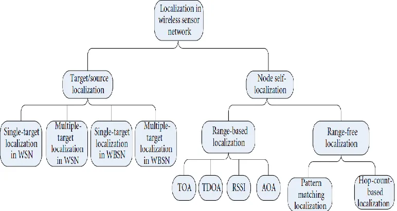
Localization in WSN represent the computing of sensor positions in some fixed coordinate system, hence it is of great importance to design an efficient localization algorithm. Localization is one of the fundamental techniques in wireless sensor network. The location estimation methods can be classified into target/source localization and node self-localization [32].
used to determine the node location within a few meters, the cost of GPS devices and the non-availability of GPS signals in confined environments prevent their use in large scale sensor networks [29]. Localization is an important and extensively studied problem in ad-hoc wireless sensor networks. Most schemes require some nodes functioned as anchors with positions configured manually which are error-prone [15], [16].
Positioning all sensors in a sensor network usually consumes a large amount of time and energy. In many applications based on sensor networks, there is no need to estimate the location of all sensors in a sensor network. Sometimes, only sensors within a given direction or region need to be located. [53].
WSNs localization methods can normally be categorized according to three different aspects: (i) the information requirements of the solution schemes: proximity-based localization, range-proximity-based localization, angle-proximity-based localization and probabilistic-based localization; (ii) the hardware requirements of the solution schemes: absolute localization and relative localization, and (iii) the type of network structure: static network and mobile network.
It is evident that localization in WSN is one of the most fundamental problems since the locations of the sensor nodes are critical to both network operations and most application level tasks. There are a number of GPS-free localization schemes that are available to date.
Based on the above it is evident that Global Positioning System (GPS) is one of the most popular positioning technologies which is widely accessible and can be deployed for localization WSN, but the weakness of high cost and energy consuming makes it different to install in every node [32]. Therefore, the need to propose a GPS-free localization algorithm becomes more important and necessary for WSN localization.
In this study, the researcher discusses sensor node localization schemes having different features used for different applications and compares the current algorithms used for nodes localization. Different algorithms of localization are used for static sensor nodes and mobile sensor nodes, describing WSNs applications, presenting an overview of localization in WSNs, and finally proposing GPS-free based localization algorithm.
1.2 THE PROBLEM STATEMENT
Most of WSN applications depend mainly on a successful node localization algorithm. In addition to that most of the current literatures on location discovery in WSNs assumes that are some nodes with known position [4], [5], [43]. Their locations are then used to determine the positions of other ordinary sensor nodes.
The localization problem in wireless sensor networks is to determine the location information of all or a subset of sensor nodes, given the measurements of pairwise spatial relationships between the nodes. In the literature, WSNs localization methods can normally be categorized according to three different aspects [36].
Unfortunately, for a large number of sensor nodes, straightforward solution of adding GPS to all nodes in the network is not feasible because of the following [2].
In the presence of dense forests, mountains or other obstacles that block the line-of-sight from GPS satellites, GPS cannot be implemented.
The power consumption of GPS will reduce the battery life of the sensor nodes and also reduce the effective lifetime of the entire network.
In a network with large number of nodes, the production cost factor of GPS is an important issue.
For these reasons a better solution of GPS localization algorithm is required and should be cost effective, rapidly deployable and can operate in diverse environments. The need for technological advances in the areas of low energy cost wireless communication embedded computing can solve this problem. However, sensor and integrated circuits make it possible to implement large scale networks with hundreds and even thousands of very small, low-cost, battery-powered, and wirelessly connected sensor and actuator nodes [28].
Environment cost of GPS devices and the non-availability of GPS signals in confined environments prevent their use in large scale sensor networks [15], [32]. In addition to that many algorithms have been proposed to minimize this communication cost. If one node estimates its wrong location, then this error propagates to overall network and further nodes; as a result, wrong information of anchor nodes location is propagated [41]
The researcher concludes that the main disadvantage of GPS-free localization is the communication cost and also the convergence time grow with the increasing number of nodes since each node participates individually in the process of building and merging the local coordinate system.
1.3 THE RESEARCH OBJECTIVES
1. To investigate the existing localization schemes for wireless sensor networks. 2. To propose a GPS-free localization scheme for the local coordinate system
formation where nodes cooperate with each other.
3. To evaluate the performance of GPS-Free localization by previous studies and make simulations to measure their performances.
1.4 THE SCOPE STUDY
Cooperative Localization method. The study extend the discussion to analyse the existing localization schemes for wireless sensor networks the used algorithm by previous scholars for nodes localization in wireless sensor networks based on local distances estimation of sensor to their neighbors using local coordinate system.
1.5 THE CONTRIBUTION OF THE STUDY
This study will contribute to the body of knowledge in wireless sensor networks in the following aspects:
The algorithms that will guaranteeing a refinery good accuracy in the sensor localization in GPS-free protocols.
1.6 RESEARCH OVERVIEW
The research is divided into five chapters as follow:
Chapter 1: The introduction of the thesis, which includes the introduction on the topic, the problem statement, the scopestudy and objectives, and research contribution.
Chapter 2: Presenting the necessary background information and literature review on localization of sensor nodes in WSN and accurate sensor localizations schemes and algorithms in wireless sensor networks.
Chapter 3: The researcher methodology. The researcher proposes the methods and algorithms used accurate distance estimation in WSN.
Chapter 4: The presentation of GPS-free localization technique used in the simulation and evaluation in the study. In the centralized sensor localization algorithm, multidimensional scaling and coordinate alignment techniques are applied to accurately estimate the distance of adjacent sensors.
CHAPTER 2
LITERATURE REVIEW
2.1 INTRODUCTION
In this chapter, the researcher discusses sensor node architecture and its applications, different localization techniques, and the research directions. Localization is one of the key techniques in wireless sensor network.
This chapter will introduce the main concept of localization of sensor nodes in wireless sensor networks and the various GPS-free algorithms for nodes localizations in WSN. In addition to that this chapter will demonstrate the various localization schemes in wireless sensor networks, and compare between the various GPS-free algorithms.
2.2 THE COMPONENTS OF SENSOR NODES
Sensor nodes network consists of software and hardware components. Hardware components are the main part in the network and include radio-transceiver sensors, processors, energy and power unit. The software is the second part of WSN, some of the major software used for administration of nodes are Tinyos, Nano Rk and Contiki, In this section, the researcher demonstrate the hardware components.
is directly generate human readable data in a digital form. Once the data is processed and converted, then data is sends back to the processor unit for further use by the administrator [14]
2. Processors. The microprocessors is one of the main parts of hardware component in WSN and is uses different types of memory in order to process data. The input/output devices and the memory are integrated on the same circuit [27]. 3. Random-access memory (RAM). The RAM stores the received data from
sensors before sending it again, while read-only memory (ROM) is used to store the operating system that run all sensors nodes in the wireless network[45], Most of the time, sensors remain at sleep mode. When the processor is in sleep mode, this does not mean it is not consuming power. In sleep mode, it is involved in other activities like time synchronization [41].
Figure 2.1: Transition of sensor node in different modes [27].
Figure 2.2: Typical architecture of sensor node [41].
2.3 THE FUNCTIONS OF WSN
The main significant function of a wireless sensor network is to collect data and forward these data to certain destination for a specific purpose. Therefore the main thing in this process is to know exactly or estimation about the location of the sensor that collected and send data to the central administration unit. This kind of information is very useful to the operator of the wireless network and can be processed and explained later depending on the application of WSN. According to the using localization technique for sensor nodes is the main task that should be done accurately in WSNs. Most schemes in WSN require some nodes functioned as anchors with positions configured manually which are error-prone [15]. While the Global Positioning System (GPS) is one of the most popular positioning technologies which is widely accessible, the weakness of this technique is mainly in high energy consuming and high cost which makes it different to install in every node and in any location.
It is evident that the main functions of sensor networks include locating, tracking, navigation, and identification of nodes that sending the target signal. The method of
Radio Transciever
Processor
Memory
Analog/Digital Circuit
[image:17.612.214.389.128.330.2]sensor networks localization is an important function especially in low sensor-information. As one of the most important functions of sensor networks, object localization and their tracking have attracted many research efforts. Large continuous objects, such as spreading wild fires and bio-chemical spills inside buildings, usually have a coverage far larger than the sensor’s sensing range. Identifying the distribution and spatial extent of the large continuous objects and tracking their movement require the collaboration of a large number of sensors. This collaboration involves high communication and complex information processing. Therefore, detection and tracking of the objects represents the most important function of WSN and represent an important research issues in sensor networks.
Based on the above, the researcher concludes that the efforts to reduce energy consumption and cost in GPS localization is unsuccessful and can use only few nodes (beacon nodes) for certain locations in the monitoring area that could be installed with GPS modules. Therefore, it is highly recommended that the rest of nodes localized through GPS-free localization method. The process of finding the location and node position within the wireless network is referred to as node self-localization.
2.4 LOCALIZATION SCHEMES IN WSN
Localization is a technique and algorithm to determine the exact or estimated location of sensor nodes in WSN. Many works and researches have been done in this subject. It is highly enviable to design energy saving method and low-cost technique for localization, anther requirement for efficient localization is the ability to scale the network [41]. Currently there are different localization algorithms are used for static sensor nodes and mobile sensor nodes.
Figure 2.3: Accuracy comparison of different localization [41].
Figure 2.4: Energy efficiency comparison of different localization [41].
[image:19.612.165.485.346.556.2]angle of arrival (AoA) data [51]. This data is typically gathered using radio or microphone arrays, which allow a listening node to determine the direction of a transmitting node. It is also possible to gather AoA data from optical communication methods. In these methods, several (3-4) spatially separated microphones hear a single transmitted signal. By analysing the phase or time difference between the signal’s arrivals at different microphones, it is possible to discover the angle of arrival of the signal. RSS is defined as a voltage measured by a receiver’s received signal strength indicator (RSSI) circuit. Often, RSS is equivalently reported as a measured power. Wireless sensor nodes communicate with their neighboring sensor node, so the RSS of the transmitted signals can be measured by each receiver during common communication without presenting additional bandwidth or energy requirements [46]. The RSS method depends mainly on low-cost hardware and only provides coarse-grained distance estimates: by contrast, the TOA and TDoA methods can provide distance estimates with higher accuracies at the cost of extra hardware. Due to cost constraints, it is impractical to equip all sensors in a large-scale sensor network with extra hardware to obtain accurate distance estimates and thus accurate location estimates [53].
Time Difference of Arrival (TDoA) is a commonly used hardware ranging mechanism. In TDoA schemes, each node is equipped with a speaker and a microphone. Some systems use ultrasound while others use audible frequencies. However, the general mathematical technique is independent of particular hardware. In TDoA, the transmitter first sends a radio message. It waits some fixed interval of time,
𝑡
𝑑𝑒𝑙𝑎(which might be zero), and then produces a fixed pattern of “chirps” on its speaker.Fig. 2.5 Time Difference of Arrival (TDoA) illustrated [19].
Localization is achieved through an estimation through a method to measure the communication between two nodes (a localized and unlocalized node), after that is could be possible to determine the geometrical placement of each node or position. In other words, the location of target node is determined by special mathematical analysis to measure the distance and angle between nodes.
Currently there are certain localization techniques which are widely used in WSN, such as the following.
(i) Lateration occurs when distance between nodes is measured to estimate location.
(ii) Angulation occurs when angle between nodes is measured to estimate location. (iii) Trilateration. Location of node is estimated through distance measurement from three nodes. In this concept, intersection of three circles is calculated, which gives a single point which is a position of unlocalized node.
(iv) Multilateration. In this concept, more than three nodes are used in location estimation.
Triangulation is the most used mechanism, where at least two angles of an unlocalized node from two localized nodes are measured to estimate the position of target node [1].
localization estimation is called relative localization, in which all devices in the network, regardless of their absolute coordinate knowledge, estimate the range between themselves and their neighboring devices. An absolute localization can be transformed into a relative localization―relative to a second reference point, that is. However, a second absolute localization is not always available [7].
[image:22.612.118.504.239.445.2]The localization method in some special scenarios [32] and the anther introduce the evaluation criteria for localization in WSN which is shown in Figure 2.6.
Figure 2.6: Taxonomy of Localization Methods.
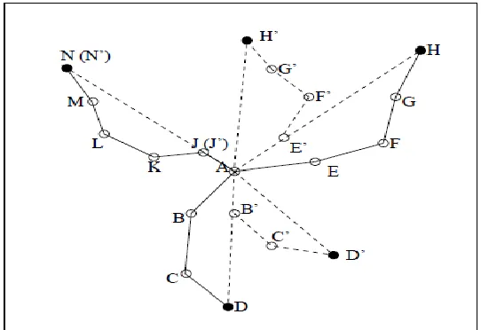
sensors. Without loss of generality, one sensor’s position is needed to be estimated. The sensor (starting sensor) first initializes flooding to pass its message to three or more anchor sensors, which are called ending anchors. The ending anchors send their locations and the flooding routes as shown in Figure 2.7.
Fig. 2.7: Position estimation in the adjacent area of a sensor without position known.
Then, the starting sensor knows the positions of ending anchors and routes to each of them. The starting sensor first simply estimates its physical position with a trilateration based on its hop distances to ending anchors, which is similar to the distance vector exchange based method [11]. Then, it estimates the positions of those sensors that are on these routes and one hop away from it. Figure 2.7 illustrates the procedure: A is the starting sensor, D , H, and N are the ending anchors. A knows the positions of D, H, and N as well as the routes to them, which are (A,B,C,D), (A,E, F, G,H), (A, J,K,L,M,N), respectively. A estimates that the position of B is B′ on dashed line AD, the position of E is E′ on dashed line AH, and the position of J is J′ on dashed line AN [53].
to each of the three nodes can be estimated. After choosing the group of nodes having the highest density in the network as the localization reference coordinate system, the other local coordinate systems can be adjusted to build the global coordinate system by coordinate transformation. The disadvantage of SPA is that the communication cost and convergence time grow exponentially with the number of nodes since each node participates individually in the process of building and merging the local coordinate system [18].
Based on the above, localization schemes are classified according to the following: Anchor based
Anchor free GPS based GPS free Range based Range free Centralized
Stationary or mobile sensor nodes Distributed
Fine grained Coarse grained
In this study, the focus will be on GPS-Free localization technique. Te next chapter describe this technique.
2.5 GPS- FREE AND GPS-BASED LOCALIZATION SCHEMS
technique here is to calculate the distance between the nodes according to local network, and because of that GPS-free schemes are less costly but accuracy is less comparing to GPS-based schemes [13]. Another important issue in GPS-free localization algorithms is the fundamental performance impact of different parameters. In particular, a set of parameter-setting guidelines for the proposed algorithm is established by making use of a probability approach. A simulation analysis on a specific numerical example is conducted to validate the mathematical analytical results of the proposed parameter-setting guidelines [29].
Another issue with GPS-based localization is the GPS is not always available because of the line of sight conditions. For instance, it does not work indoors, under water, or in a subway. Secondly, since a typical GPS receiver costs approximately one hundred dollars, it is too expensive to equip each sensor with a GPS receiver, considering that these sensors are usually designed to be low cost and disposable [53].
Finally, the GPS receivers are highly power-consuming while the sensors are designed to require low-power and therefore to ensure their greater longevity. Based on the previous discussion, alternative sensor localization systems are required. Considering the application scenarios of sensor networks, designing localization systems for sensor networks is more challenging than designing localization systems for applications in many other domains.
Most of the current literature on location discovery in WSNs assumes the availability of GPS receivers at some nodes or beacon nodes with known position. Their locations are then used to determine the positions of other ordinary sensor nodes, which do not have GPS receivers. Having a GPS receiver at sensor nodes may not be feasible due to the limitations of satellite coverage or obstructions in the path of satellite signals or harsh climate conditions [42], [51],[55].
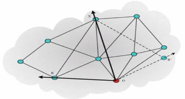
network to converge to a single global coordinate system. The, merging of two local coordinate systems is the process of one coordinate system coinciding with another using affine transformations including translation, reflection, rotation around any center, shearing and scaling as shown in Figure 2.8 [29].
Figure 2.8: Wireless sensor network after the local coordinate system is established [29].
Figure 2.9: Construction of initial coordinate system
The node with the minimum id on the comer of this triangle assumes itself at the origin of the initial coordinate system and the node with lager id is selected to form the positive x-axis [29].
2.6 GPS-FREE LOCALIZATION ALGORITHMS
The technical foundations of today’s localization techniques and present the tradeoffs inherent in algorithm design. No specific algorithm is a clear favorite across the spectrum. For example, some algorithms rely on prepositioned nodes, while others are able to do without. Other algorithms require expensive hardware capabilities. Some algorithms need a way of performing off-line computation, while other algorithms are able to do all their calculations on the sensor nodes themselves.
Localization is still a new and exciting field, with new algorithms, hardware, and applications being developed at a feverish pace; it is hard to say what techniques and hardware will be prevalent in the end.
(MSPA), where the task is to use the distance information between nodes to determine the coordinates of static nodes in a 2D or 3D space. At the heart of the approach is the matrix transform technology and a totally distributed network structure is adopted. Similar to other relative localization algorithms, the coordinate establishment phase is split into two phases: the establishment of local coordinates at a subset of the nodes and the convergence of the individual coordinate systems to form a global coordinate system. Obviously, their approach is a range-based relative localization algorithm applied in a stationary sensor network. They propose an improved versions of DVHop algorithm as QDV-Hop algorithm and UDV-Hop algorithm for better localization without the need for additional range measurement hardware. Their proposed algorithm focuses on third step of DV-Hop, first error terms from estimated distances between unknown node and anchor nodes is separated and then minimized. In the QDV-Hop algorithm, quadratic programming is used to minimize the error to obtain better localization. However, quadratic programming requires a special optimization tool box that increases computational complexity.
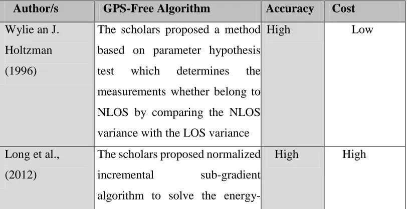
[image:28.612.114.520.507.716.2]Rather than use globally accessible beacons or expensive GPS to localize each sensor, in GPS-free localization some algorithms are centralized while others are distributed. The summary of proposals for Localization in WSN is shown in Table 2.1.
Table 2.1: Summary of proposals for Localization in WSN
Author/s GPS-Free Algorithm Accuracy Cost Wylie an J.
Holtzman (1996)
The scholars proposed a method based on parameter hypothesis test which determines the measurements whether belong to NLOS by comparing the NLOS variance with the LOS variance
High Low
Long et al., (2012)
The scholars proposed normalized incremental sub-gradient algorithm to solve the
based sensor network source localization problem where the decay factor of the energy decay method is unknown
Xiang (2004) The researcher proposes three sensor localization algorithms based on the multidimensional scaling techniques. They include a centralized sensor localization algorithm, a distributed sensor localization algorithm, and a robust sensor location algorithm based on multidimensional scaling. Three differentiated sensor localization methods are also proposed.
High Low
Guibin et al., (2010)
Argue proposed proposed a GPS-free localization scheme for WSNs that provide the ability to compute correct coordinates under a wider variety of conditions and its robustness to measurement errors.
Their algorithm includes four steps: the construction of an initial coordinate system, iterative multi-lateration, mass-spring optimization, and last, the coordinate system rotation.
Nabil et al., (2013)
The authors recommend Range-based schemes are distance- estimation and angle-estimation-based techniques. Important techniques used in range-based localization are received signal strength indication (RSSI), angle of arrival (AOA), time difference of arrival (TDOA), and time of arrival (TOA)
High Low
Huang et al., (2006)
Proposed range-free methods are distance vector (DV) hop, hop terrain, centroid system, APIT, and gradient algorithm. Range-free methods use radio connectivity to communicate between nodes to infer their location. In range-free schemes,distance measurement, angle of arrival, and special hardware are not used
Low Low
Manzoor (2010)
Proposes APIT (Approximate Point In Triangulation) scheme, anchor nodes get location information from GPS or transmitters. Unlocalized node gets location information from overlapping triangles. The area is divided into overlapping triangles. In APIT, the following four steps are
included:
(i) Unlocalized nodes maintain table after receiving beacon messages from anchor nodes. The table contains information of anchor ID, location, and signal strength.
(ii) Unlocalized nodes select any three anchor nodes from area and check whether they are in triangle form. This test is called PIT (point in triangulation) test. (iii) PIT test continue until accuracy of unlocalized node Location is found by combination of any three anchor nodes.
(iv) At the end, center of gravity (COG) is calculated.
Jonathan and
Christopher (2008)
Propose a centralized localization algorithm. Allows an algorithm to undertake much more complex mathematics than is possible in a distributed setting. They uses MDS-MAP is a centralized algorithm Instead of using semi-definite programming, however, MDS-MAP uses a technique from mathematical psychology called
[image:31.612.113.516.66.710.2]multidimensional scaling (MDS).
Lei and
Qingzheng ( (2010)
The scholars present a GPS-free localization scheme for node localization in WSNs called the Matrix transform-based Self Positioning Algorithm (MSPA), where the task is to use the distance information between nodes to determine the coordinates of static nodes in a 2D or 3D space. At the heart of the approach is the matrix transform technology and a totally distributed network structure is adopted. Similar to other relative localization algorithms.
Low Low
Shang and Ruml (2003)
The scholars present a centralized algorithm called MDS-MAP which basically consists of three steps:
1. First the scheme
Computes shortest paths between all pairs of nodes in the region of consideration by the use of all pair shortest path algorithm such as Dijkstra’s or Floyd’s algorithm.
2. Next the classical MDS is applied to the distance matrix,
REFERENCES
[1] A. Youssef and M. Youssef. 2007. “Ataxonomy of localization schemes for wireless sensor networks” . IEEE of the International Conference onWireless Networks (ICWN ’07), pp. 444–450, Las Vegas, Nev, USA.
[2] Amitangshu Pal. 2010. “Localization Algorithms in Wireless Sensor Networks: Current Approaches and Future Challenges”. Macrothink Institute Journals for Network Protocols and Algorithms. Vol. 2, No. 1.
[3] Biomedical Technology Department, College of Applied Medical Sciences, King Saud University, Riyadh 11633, Saudi Arabia
[4] Bulusu, N.; Heidemann, J.; Estrin, D. Gps-Iess low-cost outdoor localization for very small devices. IEEE Pers. Commun. 2000, 7, 28-34.
[5] Bulusu, N.; Heidemann, J.; Estrin, D.; Tran, T. Self-configuring localization systems: Design and experimental evaluation. ACM Trans. Embed. Comput. Syst. 2004, 3, 24-60.
[6] C. Huang , T. He, B.M. Blum, J. A. Stankvic, and T. Abdelzaher, 2006. “Range free localization,”
[7] Capkun, S.; Hamdi, M.; Hubaux, J.P. 2002. “Gps-free positioning in mobile ad hoc networks. Cluster Comput”. Vol (5),157-167.
[8] Capkun, S.; Hamdi, M.; Hubaux, J.P. Gps-free positioning in mobile ad hoc networks. Cluster
[10] Computer Science and Engineering. Doctor of Philosophy. The Pennsylvania State University
[11] D. Niculescu and B. Nath. 2001. “Ad-hoc positioning system”. IEEE Global Communications Conference (GLOBECOM). pp 2926–2931.
[12] Dachrach, J.; Taylor, C. 2005. “Localization in sensor networks. In Handbook of Sensor Networks: Algorithms and Architectures” Stojmenovic, I., Ed.; John Wiley and Sons: Hoboken, NJ, USA.
[13] E. Kim and K. Kim, “Distance estimation with weighted least squares for mobile beacon-based localization in wireless sensor networks,” IEEE Signal Processing Letters, vol. 7, no. 6, pp. 559– 562, 2010.
[14] F. Hu and X. Cao. 2010. “Wireless Sensor Networks: Principles and Practice”. Auerbach, Boca Raton, Fla, USA, 1st edition, 2010
[15] Guibin Zhu, Qiuhua Li, Peng Quan, Jiuzhi Ye. 2010. “A GPS-Free Localization Scheme for Wireless Sensor Networks”. Communication Technology (ICCT), 2010 12th IEEE International Conference. Pp 401-404.
[16] Guibin Zhu, Qiuhua Li, Peng Quan, Jiuzhi Ye. 2010. “A GPS-Free Localization Scheme for Wireless Sensor Networks” 978-1-4244-6871-3/10/2010 IEEE [17] H. Lim and J. C.Hou. 2009. “Distributed localization for anisotropic sensor
networks”. ACM Transactions on Sensor Networks. vol. 5, no. 2. Article 11. [18] Iyengar, R.; Sikdar, B. Scalable and distributed GPS free positioning for sensor
networks. In Proceedings of IEEE 2003 International Conference on Communications, Anchorage, AK, USA, May 2003; pp. 338-342.
[20] J. Lee, W. Chung, and E. Kim. 2011. “A new range-free localization method using quadratic programming”. Computer Communications. vol. 34. no. 8, pp. 998–1010.
[21] J. Liu, Y. Zhang, and F. Zao. 2006. “Robusr distributed node localization with error management”. The 7th ACM International Symposium on Mobile Ad-Hoc Networking and Computing (MobiAd-Hoc ’06). pp. 250–261, Florence, Italy. [22] J.Li, J. Jannotti, D. S. J. DeCouto, D. R. Karger and R. Morris. 2000. “A Scalable Location Service for Geographic Ad-Hoc Routing”, in Proceedings of Sixth Annual International Conference on Mobile Computing and Networking, August 2000, Boston, Massachusetts, USA, pp. 120-130.
[23] Jonathan Bachrach , Christopher Taylor. 2004. “Localization in Sensor Networks”. Computer Science and Artificial Intelligence Laboratory. Massachusetts Institute of Technology.
[24] K. Lu, X. Xiang, D. Zhang, R. Mao, and Y. Feng, “Localization algorithm based on maximum a posteriori in wireless sensor networks,” International Journal of Distributed Sensor. Networks, vol. 2012, Article ID 260302, 7 pages, 2012. [25] King-Yip Cheng, King-Shan Lui and Vincent Tam, “Localization in Sensor
Networks with Limited Number of Anchors and Clustered Placement”, in Proceedings of Wireless Communications and Networking Conference, 2007 (IEEE WCNC 2007), March 2007, pp. 4425 – 4429.
[26] L. Cheng, C. D. Wu, Y. Z. Zhang, and Y. Wang, “Indoor robot localization based on wireless sensor networks,” IEEE Transactions on Consumer Electronics, vol. 57, no. 3, pp. 1099– 1104, 2011.Hindawi Publishing Corporation International Journal of Distributed Sensor Networks Volume 2012, Article ID 962523, 12 pages doi:10.1155/2012/962523
Centre for Telematics and Information Technology. University of Twente. Enschede, The Netherlands.
[28] Lei Wang, Qingzheng Xu. 2010. “GPS-Free localization algorithm for wireless sensor networks. Sensors”. Vol 10 (6): pp5899-5926
[29] Lei Wang, Qingzheng Xu. 2010. “GPS-Free Localization Algorithm for Wireless Sensor Networks”. Sensors 2010, 10, 5899-5926;
doi:10.3390/s100605899
[30] Li, H.J.; Wang, J.W.; Li, X.; Ma, H.; Huang, Q.W. A distributed 3 dimension relative localization algorithm for mobile wireless sensor networks. In Proceedings of the 2007 IEEE International Conference on Mechatronics and Automation, Harbin, China, August 2007; pp. 740-744.
[31] Localization in Sensor Networks Jonathan Bachrach and Christopher Taylor Computer Science and Artificial Intelligence Laboratory Massachusetts Institute of Technology. 2010
[32] Long Cheng, Chengdong Wu, Yunzhou Zhang, HaoWu, Mengxin Li, and CarstenMaple. 2012. “A Survey of Localization inWireless Sensor Network“.International Journal of Distributed Sensor Networks. Volume 2012, Article ID 962523, 12 pages
[33] M. I. Silventoinen and T. Rantalainen. 1996. “Mobile station emergency locating in GSM”. IEEE International Conference on Personal Wireless Communications. pp. 232–238. New Delhi, India.
[34] M. Mauve, J. Widmer and H. Hartenstein. 2001. “A Survey on Position Based Routing in Mobile Ad-hoc Networks”. IEEE Network Magazine, Vol. 15, No. 6, pp. 30–39.
[36] Mao, G.Q.; Fidan, B.; Anderso n B.D.O.2007. “Wireless sensor network localization techniques. Comput. Networks”.
[37] Mao, G.Q.; Fidan, B.; Anderson B.D.O. Wireless sensor network localization techniques. Comput. Networks 2007, 51, 2529-2553.
[38] N. A. Alsindi, K. Pahlavan, and B. Alavi, “An Error Propagation Aware Algorithm for Precise Cooperative Indoor Localization”, in Proceedings of IEEE Military Communications Conference MILCOM 2006, pp. 1-7, Washington, DC, USA, October 2006.
[39] N. Patwari and A. O. Hero, “Indirect Radio Interferometric Localization via Pairwise Distances,” in Proceedings of 3rd IEEE Workshop on Embedded Networked Sensors (EmNets 2006), pp. 26-30, Boston, MA, May 30-31, 2006 [40] N. Priyantha, H. Balakrishnan, E. Demaine,and S.Teller, “Anchor-free distributed
localization in sensor networks”, MIT Laboratory for Computer Science, Technical Report TR-892, April 2003, Available HTTP:
[41] Nabil Ali Alrajeh, Maryam Bashir, and Bilal Shams. 2013. “Localization Techniques in Wireless Sensor Networks”. International Journal of Distributed Sensor Networks. Volume 2013, Article ID 304628, 9 pages
[42] Niculescu, D.; Nath, B. Ad hoc positioning system (APS) using AOA. In Proceedings of The 22nd Annual Joint Conference of the IEEE Computer and Communications Societies, San Francisco, CA, USA, April 2003; pp. 1734-1743.
[43] Niculescu, D.; Nath, B. Ad hoc positioning system (APS) using AOA. In Proceedings of The 22nd Annual Joint Conference of the IEEE Computer and Communications Societies, San Francisco, CA, USA, April 2003; pp. 1734-1743 [44] R. Manzoor. 2010. “Energy efficient localization in wireless sensor networks
[45] R. Manzoor. 2010.”Energy efficient localization in wireless sensor networks using noisy measurement”.
Record (ICUPC ’96), pp. 827–831, Cambridge, Mass, USA, October 1996. [46] S. Qureshi, A. Asar, A. Rehman, and A. Baseer. 2011. “Swarm intelligence based
detection of malicious beacon node for secure localization in wireless sensor networks”. Journal of Emerging Trends in Engineering and Applied Sciences, vol. 2, no. 4. pp. 664–672.
[47] S. R. Gandham, R. Musunuri, P. Rentala, and U. Saxena. 2004. “A survey on self-organizing
[48] Wang, J.; Ghosh, R.K.; Das, S.K. 2010. “A survey on sensor localization”. J. Control Theory Appl. 8, 2–11.
[49] Wen, C.Y.; Hsiao, Y.c.2008. “Decentralized anchor-free localization for wireless ad-hoc sensor networks”. IEEE International Conference on System, Man, and Cybernetic. Singapore. pp. 2776-2784.
.
[50] Wu, H.; Wang, C.; Tzeng, N.F. Novel self-configurable positioning technique for multi-hop
[51] X. Ji and H. Zha. 2004. “Sensor positioning in wireless ad hoc networks using multidimensional scaling”.
[52] Xiang Ji. 2004. “Localization Algorithms for Wireless Sensor Network Systems”. A Thesis in Computer Science and Engineering. The Pennsylvania State University
[53] Y. Shang, W. Ruml, Y. Zhang, and M. Fromherz. 2003. “Localization from mere connectivity”, In Proceedings of ACM Symposium on Mobile Ad Hoc Networking and Computing (MobiHoc’03), Annapolis, Maryland, USA, [54] Y. T. Chan, W. Y. Tsui, H. C. So, and P. C. Ching. 2006. “Timeof-arrival based
[55] Yu, K.; Guo, Y.J. 2009. “Anchor-free localisation algorithm and performance analysis in wireless sensor networks”. IET Commun. Vol ( 3), 549-560.
[56] Bachrach, J., & Taylor, C. (2005). Localization in sensor networks. Handbook of sensor networks: Algorithms and Architectures, 1.
[57] Lee, D. (2005). Localization using multidimensional scaling
(LMDS) (Doctoral dissertation, University of California, Berkeley).
[58] Wu, C., Sheng, W., & Zhang, Y. (2006). Mobile self-localization using multi- dimensional scaling in robotic sensor networks. The International Journal of Intelligent Control and Systems, 11(3), 163-175.
[59] T.E. Abrudan, Multi-dimensional scaling for localization, GETA Winter School Presentation, 2012.
![Figure 2.1: Transition of sensor node in different modes [27].](https://thumb-us.123doks.com/thumbv2/123dok_us/8764858.895872/16.612.148.502.84.483/figure-transition-of-sensor-node-in-different-modes.webp)
![Figure 2.2: Typical architecture of sensor node [41].](https://thumb-us.123doks.com/thumbv2/123dok_us/8764858.895872/17.612.214.389.128.330/figure-typical-architecture-sensor-node.webp)
![Figure 2.3: Accuracy comparison of different localization [41].](https://thumb-us.123doks.com/thumbv2/123dok_us/8764858.895872/19.612.165.485.346.556/figure-accuracy-comparison-different-localization.webp)
![Fig. 2.5 Time Difference of Arrival (TDoA) illustrated [19].](https://thumb-us.123doks.com/thumbv2/123dok_us/8764858.895872/21.612.187.459.80.236/fig-time-difference-arrival-tdoa-illustrated.webp)
![Figure 2.8: Wireless sensor network after the local coordinate system is established [29]](https://thumb-us.123doks.com/thumbv2/123dok_us/8764858.895872/26.612.135.516.156.357/figure-wireless-sensor-network-local-coordinate-established.webp)