2017 2nd International Conference on Manufacturing Science and Information Engineering (ICMSIE 2017) ISBN: 978-1-60595-516-2
The Design and Implementation of Agricultural
Base Virtual Roaming System Based on the
720
°
Panorama
Mengjiao Zhang, Jingwen Xu, Erqiang Li and Juncheng Wu
ABSTRACT
Virtual reality technology is the important application in the field of agricultural tools and agricultural researchers which focus with the progress of science and technology and the reform and development of agriculture. This system shows the double 360° spherical domain within the scope of agricultural base of the real environment and achieve the panoramic view, information query, navigation map, sales of agricultural products and source, and a series of auxiliary and interactive functions with the aid of 720° panoramic technology, based on the Krpano development platform and WebStorm code editing tool. The successful application of this system not only indicates that 720° panoramic technical feasibility and practicability, but also for the application of this technology in other industries to provide experience for reference.1
INTRODUCTION
The concept of "virtual reality" was put forward in the early 1990s. As the "Internet +" is put forward and the development of information technology, virtual panoramic agricultural planting base construction will become an important development direction about future agriculture base environment display,
promotion, sales, etc[1-5]. Therefore, this system to a modern agricultural base as an example, using unmanned aerial vehicle (UAV) to build modern agriculture planting base virtual panorama and repetition the real scene of regional agriculture planting base.
THE DEVELOPMENT OF LANGUAGE AND PLATFORM
The system development based on Krpano development platform, WebStorm code editing tools and in HTML 5 for the development of language, and Choose the type B/S architecture.
PANORAMIC VIRTUAL SCENE BUILDING
Panoramic Image Data Acquisition
In this article, using the fish-eye lens, digital camera, cloud deck, tripod for every angle after joining together to get a panoramic image. Before shooting to agricultural base for comprehensive investigation and to determine the specific location, shooting time had better choose the morning sunshine and no wind, avoid the strong sunshine and rainy day. Second, in every time before shooting for debugging the parameters of the camera[6].
Panoramic Image Stitching Technology
PTGui software is adopted to improve the image matching in this paper. From the original photo to the completion of the input to the panoramic photos, mainly includes the following steps in order to load the image, image direction order adjustment, image lens set, projection mode, the control points of the acquisition and suture, image optimization, the output image[7, 8].
THE DESIGN AND IMPLEMENTATION OF AGRICULTURAL BASE VIRTUAL ROAMING SYSTEM BASED ON KRPANO
The System Main Interface
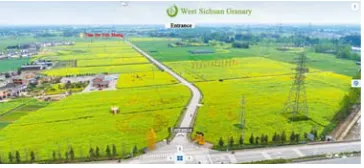
Figure 1. The system interface.
Panoramic View Query Module
The module mainly includes the panorama browsing and information query function. All the sites link together with hot method, by the navigation bar or icon can realize quickly switch between panoramic views. In the scene with glare to replace the artificial lighting, and joined the background music and particle effects, thus greatly improving the beautiful scene. Secondly, through the information query tool can pop-up window, it recorded the text information of observation point.
Map Navigation Module
The map function is to supplement and complete the panorama browsing, it including the basic operation function, map click query switch function and map reproduction function. Through access to Google map make the system has perfect location information sharing function. Users can understand the observation point of geographical spatial location and the position relationship between other observation points through the map in the process of switching different observation points. Using two-dimensional map and grid satellite images as a base, between the two can switch to each other. The scene node and map matching through the hotspot technology, so users can quickly into the corresponding location of the virtual view by clicking the hot spot on the map, and then also can query all other attractions to the current distance all spots on the navigation map.
Auxiliary and Interactive Function Module
Agricultural Products to Buy and Source Module
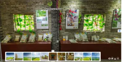
[image:4.612.197.400.194.297.2]This system provides online traceability function of agricultural products, can view of crop fertilization, pesticide use, climate report, agricultural growth report and so on by clicking on the appropriate icon. Secondly, as shown in figure 2, this system by embedding the traditional mall has realized the online tour, product pre-sales, sales a line service.
Figure 2. Commodity purchase.
CONCLUSIONS
In this paper, the successful implementation of agricultural base of virtual roaming system proves the feasibility of 720 ° panoramic technology and solves the panorama splicing and synthesis. Achieve the panoramic view, navigation, map query, sales of agricultural products and source, and a series of complementary and interactive functions through the krpano and WebStorm. Using UAV shooting and the ground panorama shooting two ways, it enriches the information of virtual scene and improves the truth of the scene and meets the needs of publicity, sales, management of modern agricultural base, but there is also a need to improve, so the next research direction is how to gather the image in the complex environment and improve the resolution of the images. Second, improve the interactivity of system through into the panoramic technology, geographic information technology, simulation technology.
REFERENCES
1. Slater M., Sanchez-Vives M.V. 2016. Enhancing Our Lives with Immersive Virtual Reality. Frontiers in Robotics and AI. 20(3): 1-47.
2. Brooks, F.P. 1999. What's Real About Virtual Reality? IEEE Computer Society Press. 19 (6): 16-27.
4. Fineschi A., Pozzebon A. 2016. A 3D virtual tour of the Santa Maria della Scala Museum Complex in Siena, Italy, based on the use of Oculus Rift HMD. International Conference on 3d Imaging. IEEE. pp. 1-5.
5. Ardouin J., Lecuyer A., Marchal M., et al. 2014. Navigating in virtual environments with 360° omnidirectional rendering. 3d User Interfaces. IEEE. pp. 95-98.
6. Jain L.C., Favorskaya M.N., Novikov D. 2015. Panorama construction from multi-view cameras in outdoor scenes. Intelligent Systems Reference Library, 75(4): 71-108.
7. Zhang K., Sheng Y., Ye C. 2010. Digital close-range stereo image matching based on digital Ge Z. 2013. A new optimal seam finding method based on tensor analysis for automatic panorama construction. Pattern Recognition Letters, 34(3):3 08-314.