https://doi.org/10.5194/hess-21-5427-2017 © Author(s) 2017. This work is distributed under the Creative Commons Attribution 3.0 License.
Forest impacts on snow accumulation and ablation across an
elevation gradient in a temperate montane environment
Travis R. Roth and Anne W. Nolin
Water Resource Sciences, Oregon State University, Corvallis, OR 97331, USA
Correspondence to:Travis R. Roth ([email protected]) Received: 5 October 2016 – Discussion started: 1 November 2016
Revised: 5 September 2017 – Accepted: 9 September 2017 – Published: 6 November 2017
Abstract.Forest cover modifies snow accumulation and ab-lation rates via canopy interception and changes in sub-canopy energy balance processes. However, the ways in which snowpacks are affected by forest canopy processes vary depending on climatic, topographic and forest char-acteristics. Here we present results from a 4-year study of snow–forest interactions in the Oregon Cascades. We con-tinuously monitored snow and meteorological variables at paired forested and open sites at three elevations represent-ing the Low, Mid, and High seasonal snow zones in the study region. On a monthly to bi-weekly basis, we surveyed snow depth and snow water equivalent across 900 m transects con-necting the forested and open pairs of sites. Our results show that relative to nearby open areas, the dense, relatively warm forests at Low and Mid sites impede snow accumulation via canopy snow interception and increase sub-canopy snow-pack energy inputs via longwave radiation. Compared with the Forest sites, snowpacks are deeper and last longer in the Open site at the Low and Mid sites (4–26 and 11–33 days, respectively). However, we see the opposite relationship at the relatively colder High sites, with the Forest site maintain-ing snow longer into the sprmaintain-ing by 15–29 days relative to the nearby Open site. Canopy interception efficiency (CIE)
val-ues at the Low and Mid Forest sites averaged 79 and 76 % of the total event snowfall, whereasCIEwas 31 % at the lower
density High Forest site. At all elevations, longwave radia-tion in forested environments appears to be the primary en-ergy component due to the maritime climate and forest pres-ence, accounting for 93, 92, and 47 % of total energy inputs to the snowpack at the Low, Mid, and High Forest sites, re-spectively. Higher wind speeds in the High Open site signif-icantly increase turbulent energy exchanges and snow sub-limation. Lower wind speeds in the High Forest site create
preferential snowfall deposition. These results show the im-portance of understanding the effects of forest cover on sub-canopy snowpack evolution and highlight the need for im-proved forest cover model representation to accurately pre-dict water resources in maritime forests.
1 Introduction
Maritime snowpacks accumulate and reside at temperatures near the melting point. Such snowpacks do not fit the simple accumulation–ablation model of a monotonic increase until peak snow water equivalent (SWE) followed by a monotonic decrease to snow disappearance. Such temperature sensitive snowpacks may experience disproportionate effects of cli-mate warming and changing forest cover (Nolin and Daly, 2006; Dickerson-Lange et al., 2015). Ramifications of these impacts have far reaching eco-hydrological impacts across the snowmelt dependent western US, highlighting the contin-ued need for research into snow–forest process interactions in maritime montane settings (Mote, 2006; Harpold et al., 2015; Vose et al., 2016).
In the Pacific Northwest, United States (PNW), mountain environments are a disparate composite of forest cover driven by forest harvest, regrowth, and natural disturbance. Forest disturbance can have significant impacts on snow processes, whose effects can range from immediate (Boon, 2009) to decadal (Lyon et al., 2008; Gleason and Nolin, 2016). At the stand scale, forests attenuate wind speeds, thereby suppress-ing turbulent mixsuppress-ing of the near-surface atmosphere (Lis-ton and Sturm, 1998); modify the radiation received at the snow surface through shifts in shortwave and longwave con-tributions and reduced surface albedo (Sicart et al., 2004; O’Halloran et al., 2012; Gleason et al., 2013); and tempo-rally shift seasonal- and event-scale accumulation and abla-tion patterns through canopy snowfall intercepabla-tion (Varhola et al., 2010). Natural and anthropogenic alterations in for-est cover such as mountain pine beetle inffor-estation, forfor-est management practices, and forest fire affect snow processes by modifying forest structure, i.e., canopy cover and gap size (Boon, 2009; Bewley et al., 2010; Ellis et al., 2013) and snow albedo (Gleason et al., 2013; Gleason and No-lin, 2016). The frequency and intensity of forest fires have been increasing (Westerling et al., 2006; Miller et al., 2009; Spracklen et al., 2009), impacting accumulation and ablation rates (Gleason et al., 2013), and are anticipated to continue increasing (Moritz et al., 2012; Westerling et al., 2011), while prolonged droughts, and a future of increasing drought preva-lence, have increased water stress, creating changes in forest characteristics across the western US (Allen, 2010; Choat, 2012; Dai, 2013). Disturbances of this type alter the snow– forest dynamic through a modification of the magnitudes of central process relationships, often resulting in unanticipated outcomes (Lundquist et al., 2013). The present reality and specter of continued future change to climate and forest cover underscores the increasing importance of characterizing veg-etation impacts on snow accumulation and ablation within warm, topographically varied terrains.
Elevation (as a proxy for temperature) and forest canopy cover are important controls on peak snow accumulation (Geddes et al., 2005; Jost et al., 2007). Elevation drives snow accumulation and is the principle predictor of peak snow wa-ter equivalent (Gray, 1979; Elder et al., 1991; Sproles et al., 2013). The partitioning of precipitation between rainfall and
snowfall is determined by atmospheric temperature and the elevation of the rain–snow transition can be described as a function of the temperature lapse rate. Forest canopies in-tercept snow, reducing sub-canopy accumulation (Schmidt and Gluns, 1991; Hedstom and Pomeroy, 1998; Musselman et al., 2008). The magnitude and rate of canopy intercep-tion are also affected by air temperature. Air temperature has been shown to have an inverse relationship with canopy in-terception (Andreadis et al., 2009) and a nonlinear correla-tion with event size (Hedstrom and Pomeroy, 1998); these relationships are often based on a few measurements and at a single point. Forests also reduce solar radiation reaching the snowpack surface (Link and Marks, 1999; Hardy et al., 2004) and increase longwave radiation at the snowpack sur-face (Lundquist et al., 2013), thus modifying net radiation (Sicart et al., 2004). Forest cover reduces wind speed, thereby reducing latent and sensible heat flux at the snowpack sur-face (Link and Marks, 1999; Boon, 2009). The direct effect of wind speed on canopy snow interception has not been explicitly studied, with most research focusing on wind re-distribution of snow (Gary, 1974; Pomeroy et al., 1997; Lis-ton and Sturm, 1998; Woods et al., 2006). Research demon-strates that forests reduce wind speed and can lead to in-creased snow accumulation in canopy gaps or forest clearcuts where wind speeds decline and snow is released from upwind canopy flow (Gary, 1974). These combined forest effects on sub-canopy energy and mass balance can accelerate or delay the onset and rate of snowmelt (Varhola et al., 2010). These studies highlight the key differences between forested and open areas, and the effects of elevation on snowpack evo-lution. With strong agreement that the western US will be facing warmer winters in the future and new understanding that snow in forested regions is more sensitive to increased temperatures than snow in non-forested regions (Lundquist et al., 2013), it is critical that we measure, characterize, and understand maritime snow–forest interactions. This study ex-amines and evaluates the combined effects of forest cover, climate variability, and elevation on snow accumulation and ablation in a maritime montane environment. Specifically, we focus on the following research questions.
1. To what extent do forests modify snow accumulation and ablation in a maritime temperate forest?
2. How does canopy interception affect sub-canopy snow-pack evolution across an elevation gradient?
3. How does forest cover affect the sub-canopy snow sur-face energy balance relative to adjacent open areas and what are the principal drivers of melt?
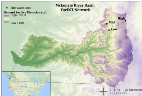
Figure 1.The Oregon ForEST network sites of the McKenzie River basin.
2 Methods
2.1 Description of the study area
The McKenzie River basin (MRB) is part of the greater Willamette River basin in western Oregon, USA (Fig. 1). It covers an area of 3041 km2and spans an elevation range from 150 m to over 3100 m at the crest of the Cascades Mountains that flank its eastern boundary. Orographic up-lift results in average annual precipitation ranging from 1000 mm at lower elevations to over 3500 mm at the highest elevations in the basin (Jefferson et al., 2008). The rain–snow transition zone sits between 500 and 1200 m (Marks et al., 1998). The area above the transition zone accounts for 12 % of the total area with the Willamette River basin, yet con-tributes 60–80 % of summer baseflow to the Willamette River (Brooks et al., 2012). The MRB elevation between 1000 and 2000 m is especially important as it comprises 42 % of the total area within the MRB and snowmelt from this eleva-tion band accounts for nearly 93 % of the total snow water storage (Sproles et al., 2013). Warm snowpack conditions facilitate frequent melt events during the winter months of December, January and February (DJF), commonly mask-ing the distinction between accumulation and ablation peri-ods. Nolin and Daly (2006) showed that snowpack in this region has an acute sensitivity to temperature, with the low elevation snow zones of the Oregon Cascades classified as the most “at-risk” snow within the region. The Natural Re-sources Conservation Service (NRCS) has been monitoring seasonal snowpack within the MRB since the early 1980s by a point-based snow telemetry (SNOTEL) network. Place-ment of SNOTEL stations was designed to be representative of water producing regions of a watershed and yet network stations were ultimately placed in protected, accessible loca-tions (Molotch and Bales, 2006). However, the limited con-figuration was not designed to understand forest–snow pro-cesses or with future climate change in mind, and therefore
a statistically unbiased approach to site selection that is spa-tially representative is needed for any substantial snow obser-vation network (Molotch and Bales, 2006). This underscores the need for intelligent and statistically relevant snow moni-toring sites that go beyond the existing network. Section 2.2 outlines the snow monitoring network we deployed in water year (WY) 2012 that meets these stated needs.
2.2 The Oregon ForEST network
The Oregon Forest Elevation Snow Transect (ForEST) net-work extends from the rain–snow transition zone through the seasonal snow zone in the Oregon Cascades with paired forested and open sites at three elevations, Low (1150 m), Mid (1325 m) and High (1465 m) (Fig. 1). The ForEST net-work was designed to efficiently represent the range of peak SWE within the basin. Using a binary regression tree (BRT) approach, we identified elevation, vegetation type and vege-tation density as the key predictor variables and we used them to classify the basin and locate our network sites (Molotch and Bales, 2006; Gleason et al., 2017). At each of three el-evation zones, we established Open (low forest density) and Forest (high forest density) site pairs in adjacent areas, while controlling for slope and aspect. Open sites consisted of <20 % canopy cover, while corresponding Forest sites had >60 % canopy cover based on the 2001 National Vegetation Cover Database (Homer et al., 2007), and were subsequently verified by in situ measurements.
e.g., Open or Forest sites, SWE measurements were made at 100 m intervals with snow depth measurements every 5 m. Snow course data used in this analysis are from WY 2012 to WY 2015 for all ForEST network sites. To estimate SDD for each site we calculated the snowpack ablation rate using median snow depths from the last two snow courses of the season and linearly extrapolating to the date of zero snow depth. SDD represents the date when the primary seasonal snowpack disappears and does not take into account late sea-son periods of accumulation/ablation. We excluded data from the historically low WY 2015 due to a near absence of winter snow.
2.3 Canopy interception efficiency
Forest structure characteristics at each site were quantified using ground-based conventional forest inventory methods. At transect locations coinciding with SWE measurements, individual tree characteristics were measured within each quadrat and averaged for that particular site, i.e., diame-ter at breast height (DBH), crown radius, tree height, and tree species (Table 1). Forest density was performed using a plotless density estimator approach described in Elzinga et al. (1998). The forest canopy at each site was further char-acterized using skyward looking hemispherical photographs acquired using a Nikon Coolpix 990 digital camera equipped with a FC-E8 fisheye converter, which has a 180◦ field-of-view (Inoue et al., 2004). The hemispherical photographs were assessed with the Gap Light Analyzer 2.0 to measure leaf area index (LAI) and canopy closure (CC), which is the complement of the sky view fraction (Frazer et al., 1999).
During the snow accumulation period forest canopy plays a large role in reducing snowpack by intercepting incoming snowfall, prohibiting a significant portion from accumulat-ing on the forest floor. A forest canopy is the integrated sum of the forest overlaying the ground surface; this includes nee-dles, leaves, branches, and trunks. The canopy structure is the primary control on canopy interception, followed by event-specific variables, i.e., event size, air temperature, and wind speed (Varhola et al., 2010). Canopy snow interception is in-herently difficult to accurately quantify due to the temporally sensitive impacts of local climate on the canopy itself and the limited measurement capabilities to directly measure canopy interception (Martin et al., 2013; Friesen et al., 2014). From measured snowfall at each climate station within the ForEST network we calculated percent canopy interception efficiency (CIE) for daily snowfall events. A snowfall event is defined as
the daily increase in measured snow depth in the Open sites greater than 3 cm. Ryan et al. (2008) showed that acoustic snow depth measurement error for the Campbell Scientific SR50a is±2 cm under normal field conditions. Therefore, to reduce the influence of depth measurement error on our snow event classification, we used a≥3 cm threshold for our
anal-ysis.CIEis calculated as
CIE=
O
S−FS
OS
×100, (1)
whereOSandFSare the measured snowfall (cm) in the Open
and Forest sites, respectively.CIEwas calculated for
individ-ual events and for seasonal averages at each Forest site. 2.4 Snow surface energy balance
A snow surface energy balance was calculated at a daily time step using aggregated 10 min meteorological measure-ments from each site. Each energy balance component was either directly measured or calculated using empirically de-rived equations valid for a maritime snowpack. Total energy into the snowpack equals the combined incoming and outgo-ing energies experienced at the surface of the snowpack. The governing equation for the snow surface energy balance is 1Q=QS+QL+QE+QH+QC (2)
where 1Q is the change in total energy present at the snow surface (W m−2);QSis total solar radiation (W m−2);
QL is total longwave radiation (W m−2);QE is latent heat
(W m−2);Q
H is sensible heat (W m−2); andQCis
conduc-tive energy (W m−2).
A critical component within the snow surface energy bal-ance calculations is the determination of the snow surface temperature, Tsnow (Andreas, 1986). Tsnow controls
direc-tional energy flows by regulating temperature and vapor flux gradients between the atmosphere and the snowpack, which control the sensible and latent heat transfer, respectively. Tsnowis also the primary control of longwave radiation
emit-ted from the snowpack. However, Tsnow is difficult to
di-rectly measure and is therefore estimated as a function of the dew-point (frost-point) temperature,Tdew, as demonstrated
by Raleigh et al. (2013). UsingTdewto estimate daily
aver-ages ofTsnowreduces bias and is a reasonable first-order
ap-proximation at standard height measurements (Raleigh et al., 2013).
2.4.1 Solar radiation
Incoming and reflected solar radiation were each measured using an upward facing and downward facing LI-200s™ pyranometer (LI-COR). The pyranometers have a spectral range of 400–1100 nm and a field-of-view of 180◦. Net solar radiation is calculated as
QS=Sin×(1−α) (3)
whereSin equals the measured incoming shortwave
radia-tion (W m−2). Albedo,α, was calculated as the ratio of re-flected and incoming measured solar radiation. When periods of newly fallen snow obscured the upward facing solar pyra-nometer, i.e., when Sout
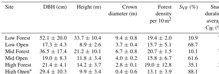
Table 1.Site forest characteristics with the associated SD for each measurement.
Site DBH (cm) Height (m) Crown Forest SVF(%) Study
diameter (m) density duration
per 10 m2 average
CIE(%)
Low Forest 52.1±20.0 33.7±10.4 9.4±0.8 19.4±2.0 10.9 79
Low Open 17.3±4.3 8.9±2.6 3.7±0.4 15.7±5.1 68.7 –
Mid Forest 36.5±17.4 21.2±10.1 6.7±0.8 20.7±1.5 10.1 76
Mid Open 19.0±8.3 11.8±3.4 4.0±0.2 15.8±6.7 61.6 –
High Forest 21.4±4.1 14.2±3.7 2.8±0.1 19.0±12.8 35.1 39 High Open∗ 29.4±10.3 9.9±3.4 0.4±0.6 13.1±3.9 88.1 –
∗Includes fire related standing dead trees.
Similarly, when Sout
Sin <0.3,a value of α=0.3 was used to adequately simulate the lower bound of forest floor albedo during the ablation period (Melloh et al., 2002).
2.4.2 Longwave radiation
Longwave radiation is rarely directly measured in the sea-sonal snow zone due to the high cost in both absolute, e.g., in-strument cost, and relative terms, e.g., energy requirements. Longwave radiation balance was calculated as
QL=L↑ +L↓ (4)
whereL↓is the calculated longwave radiation received by the snowpack surface and L↑ is the calculated longwave radiation emitted by the snow surface. Longwave radiation emitted at the snow surface is approximated by
L↑=εsnowσ Tsnow4 (5)
whereεsnowis the snow surface emissivity and is set at 0.96
(Link and Marks, 1999).
A variety of empirically derived formulas exist for cal-culating incoming longwave radiation under clear (Lclear)
and cloudy skies at various sites throughout the world (Brut-saert, 1975; Sicart et al., 2004; Flerchinger et al., 2009). All derivations are variations of the general form of the Stefan– Boltzmann equation that relates clear sky incoming long-wave radiation to atmospheric emissivity (εclear), the Stefan–
Boltzman constant (σ), and air temperatureTair(K).
Lclear=εclearσ Tair4 (6)
Many of these parameterizations are site specific or do not incorporate a cloud cover component or account for long-wave radiation emitted from the canopy (Hatfield et al., 1983; Alados-Alboledas et al., 1995). The presence and type of cloud cover affects how longwave radiation is absorbed and transmitted through the atmospheric air column, significantly affecting emissivity and subsequently the magnitude of in-coming longwave radiation (Sicart et al., 2004; Lundquist
et al., 2013). Incorporating a sky view factor (SVF) into the
longwave radiation calculations allowed us to partition the incoming longwave into atmospheric and forest canopy con-tributions.
Following Flerchinger et al. (2009) we performed a com-parative analysis of various longwave radiation algorithms and measured net longwave radiation. Table S2 shows two clear sky algorithms and three cloud correction algo-rithms used in the comparison, totalling six combinations in all, with the “best-fit” algorithm determined by root mean squared error (RMSE). We measured longwave radiation us-ing a Huskeflux NR1 net radiometer durus-ing sprus-ing 2013 for a 2-week period in a forested site within the MRB (Glea-son et al., 2013) and for a 10-day period in an adjacent open area, excluding a 4-day period of rain. The NR1 measures four separate components of the surface radiation balance, separately measuring incoming and reflected solar radiation and both incoming and outgoing far infra-red radiation. The pyrogeometers have a built-in Pt100 temperature sensor for calculation of both the sky and surface temperature. Addi-tionally, they are heated, with temperature compensation, to avoid moisture build-up on the thermopile sensors. The pre-dicted incoming longwave radiation results of each method were then compared to the NR1 measured incoming long-wave radiation using RMSE (Table S3). We found that the best approximation for incoming longwave energy was the clear sky algorithm of Dilley and O’Brien (1998) combined with the cloud adjustment of Crawford and Duchon (1999). The combined Crawford–Dilley method was therefore used in all longwave calculations going forward and is calculated as
L↓=(SVF) εadjσ Tair4 +(1−SVF) εsnowσ (TC4) (7)
where SVF is the sky view factor and represents the frac-tion of viewable sky from the perspective of the ground sur-face;εadjis the adjusted atmospheric emissivity; and TCis
the temperature of the forest canopy (K).TCis highly
measured air temperature (Derby and Gates, 1966; Pomeroy et al., 2003; Essery et al., 2008). We assumed canopy tem-perature to be equal toTair+4 K based on Boon (2009).
Ad-justed emissivity accounts for changes in atmospheric emis-sivity due to cloud cover and is found by adjusting the clear sky emissivity (εclear) by some estimation of cloud cover. The
Dilley and O’Brien (1998) clear sky algorithm is as
Lclear=59.38+113.7·
T
air
273.16
6
+96.96
r
ω
25, (8) ω=465
eo
100
Tair
. (9)
The Crawford and Duchon (1999) cloud correction adjusted algorithm requiresεclear, which we computed from Eq. (8)
and is in the following form:
εadj=(1−r)+r·εclear, (10)
whereris the solar ratio, an approximation of cloud cover, and is equal to the ratio of measured incoming solar radiation and potential solar radiation (Lhomme et al., 2007).
2.4.3 Turbulent heat flux
The turbulent fluxes of latent and sensible heat are calculated using indirect methods. Latent heat exchange was calculated using the method found by Kustas et al. (1994):
QE=
ρa0.622
Lv
Pa
CeUZ(ea−e0) , (11)
whereρais the density of air (kg m−3),Lvis the latent heat
of vaporization or sublimation (J kg−1), Pa is the total
at-mospheric pressure (Pa), Ce is the bulk transfer coefficient
for vapor exchange,U (z)is the wind speed at heightZ(m) above the snow surface (m s−1),eais the atmospheric vapor
pressure at height Zabove the snow surface (Pa), ande0is
the vapor pressure at the snow surface (Pa). This calculation favors the bulk aerodynamic approach adapted from Brut-saert (1982), as direct measurement is limited and success-ful implementation difficult in remote environments (Moore, 1983; Marks and Dozier, 1992; Marks et al., 1998). Cen is
the bulk transfer coefficient for vapor exchange under neu-tral stability and is calculated as
Cen=k2
ln
Z
Z0
−2
(12) wherekis von Karman’s constant 0.4 (−) andZis the height of the measurement above the snow surface (m) and was 3 m above the snow-free ground surface for the Low and Mid sites and 4.5 m for the High sites. Additionally, the surface roughness lengthZ0is a primary control on the bulk
trans-fer coefficient, Eq. (12). The roughness length is affected by snow properties and is generally found to have values rang-ing from 0.001 to 0.005 m (Moore, 1983; Morris, 1989). This
value represents the mean height of snow surface obstacles that impede air movement over the snow surface. In our anal-ysis we used a median value, 0.003 m, due to the variable nature of the seasonal snowpack.
The bulk aerodynamic approach is guided by stability con-ditions in the air above the snow surface. The stability of the air column is determined by application of the dimension-less bulk Richardson number(RiB)which relates the density
gradient to the velocity gradient, in this case the energy of buoyancy forces to the energy created by shear stress forces.
RiBis calculated as
RiB=
g Z (Tair−Tsnow)
0.5(Tair+Tsnow) U (z)2
(13)
whereg is the acceleration due to gravity, 9.81 m s−2. As Eq. (13) shows, the stability of the atmosphere is tempera-ture dependent. Under stable conditions where the relatively warm air column settles the snow surface will cool and be-come dense, impeding turbulent mixing. Conversely, when the air column is relatively colder than the snow surface, free convection of the air column exists where the air warms and expands, causing increased mixing and unstable conditions. Positive values of RiB indicate stable conditions, whereas
negative values indicate instability. Corrections for atmo-spheric stability effects are inconsistent within the literature and therefore remain an area of continued study (Anderson, 1976; Oke, 1987; Kustas et al., 1994; Andreas, 2002). In this study we employ Eqs. (14a) and (14b) as the general stability correction equations (Oke, 1987):
Unstable: Ce Cen
=(1−16RiB)0.75; (14a)
Stable: Ce Cen
=(1−5RiB)2. (14b)
Sensible heat exchange, much like latent heat exchange, is controlled by temperature, wind speed, roughness length, and atmospheric stability conditions. Sensible heat flux was calculated as
QH=ρaCpChua(Tair−Tsnow) (15)
wherecpis the specific heat of dry air (J kg−1K−1) andCh
is the bulk transfer coefficient for sensible heat. Here we as-sumed thatCe=ChandCen=Chn.
3 Results
3.1 Snow surveys
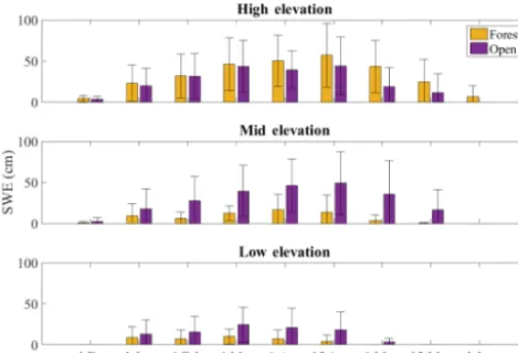
Figure 2.Average snow water equivalent (SWE) for the Open and Forest sites within the ForEST network, WY 2012–2014.
for WY 2012–14 show SWE at the Open site to be consis-tently greater and snow cover lasting longer into the spring than at the adjacent Forest site (Fig. 2). During the average snow year of WY 2013 (93 % of the 30-year median) the Low and Mid sites showed substantial differences between Open and Forest SWE throughout the accumulation and ab-lation seasons, whereas at the High sites SWE amounts were similar in Open and Forest. Conversely, snow lasted longer into the spring at the High Forest site relative to the High Open site. Because 1 April SWE may not accurately repre-sent annual peak SWE at low and mid elevations within the PNW, we use the date of peak SWE in the following anal-ysis. Therefore, peak SWE at the Low Open site was 209, 215, 225, and 242 % of the Forest site peak SWE, respec-tively, for WY 2012–WY 2015. Peak SWE at the Mid Open site was 200, 280, 328, and 302 % of the Forest site peak SWE, respectively, for WY 2012–WY 2015. However, SWE at the High Forest site is consistently higher than at the High Open site, 111, 103, 125, and 110 % for WY 2012–WY 2015, respectively.
Excluding the historically low snowpack of WY 2015 (Sproles et al., 2017), the 3-year average snow depth ab-lation rates in the Forest sites at Low and Mid elevation were 1.3 and 1.2 cm d−1, while the Open sites were 4.1 and 3.1 cm d−1, respectively (Table 2). Melt rates at the High site were greater at both sites than their lower elevation counter-parts, with a rate of 4.7 cm d−1 at the High Open site and a rate of 3.2 cm d−1 for the High Forest site. At Mid Open
snow persistence exceeds that of the Mid Forest site by 11– 33 days. This is a similar finding to the low elevation sites, where snow lasted longer at Low Open by 4–26 days com-pared with the Low Forest site. Conversely, the High For-est site maintains snow longer into the spring by 15–29 days when compared to the High Open site.
3.2 Forest characteristics and canopy interception efficiency
Results show thatCIE in the Low and Mid Forest sites, for
WY 2012–WY 2015, was 79 and 76 % of the total event snowfall, whereasCIEwas 31 % at the High Forest site
(Ta-ble 2).CIEshowed no significant threshold behavior between
event size andCIE, although there is an inverse relationship
between duration andCIEat the Low and Mid sites. Events
that lasted for a single day had an average canopy intercep-tion efficiency of 87 % with a reducintercep-tion in averageCIEwith
increasing event length, from 73 % for a 2-day event and 57 % for a 3-day event to 51 % for any event lasting longer than 4 days. Due to the low snow years of WY 2014 and WY 2015 the High site had only four events that lasted longer than 1 day, and therefore no relationship with event duration could be identified. Using event-basedCIE for all snowfall
events we calculated how much snow was removed by the canopy at each elevation and compared that with each event snowfall amount (Fig. 3). The low elevation site has a high correlation between CIE and event size for all qualifying
events (R2=0.86) and an estimated overall snow removal efficiency of 58 %. The Mid elevation site has a lower corre-lation (R2=0.64) betweenCIEand event size and an overall
snow removal efficiency of 42 %. The linear relationship of the Low and Mid sites is similar to what Storck et al. (2002) found for a single Douglas fir (Pseudotsuga menziesii) over a 2-year study in Oregon, that 60 % of event snowfall was intercepted by the canopy. This relationship does not hold at the high elevation site, with an overall snow removal ef-ficiency of only 4 %. Further analysis using the Spearman rank correlation non-parametric measure shows similar re-sults. The Spearman rank correlation coefficient (rs) is 0.89
for both the low and mid elevation sites. This correlation does not persist at the high elevation sites (rs= −0.05). We note
an apparent threshold behavior where events less than 15 cm have a stronger linear relationship between event size and CIE(Fig. 3) and the canopy was more effective at snow
re-moval for events in that range compared with events greater than 15 cm. For events <15 cm, canopy removal rates in-crease to 88 % for the Low site and 89 % for the Mid site, and interestingly, a weak correlation emerges, R2 of 0.27, with 50 % removal for the High site.
3.3 Energy balance
Table 2.Summary snow statistics for WY 2012–WY 2014 – Oregon ForEST network.
WY2012 WY2013 WY2014
Site Peak CIE Ablation Peak CIE Ablation Peak CIE Ablation
SWE (%) rate (depth SWE (%) rate (depth SWE (%) rate (depth
(cm) cm day−1) (cm) cm day−1) (cm) cm day−1)
Low Forest 23 70 1.6 24 75 1.9 8 92 0.4
Low Open 48 – 4.0 51 – 4.3 18 – 1.3
Mid Forest 45 70 1.0 26 75 1.3 12 83 1.1
Mid Open 89 – 3.8 73 – 2.5 38 – 4.5
High Forest 100 – 4.1 73 – 2.4 59 39 3.1
High Open 90 – 5.4 71 – 2.9 42 – 5.9
Figure 3.Canopy interception depth vs. event snowfall within the ForEST network.
amount of energy at the monthly or annual timescales. On an annual basis, shortwave radiation is the primary compo-nent of the energy balance at all Open sites, whereas long-wave radiation dominates at all Forest sites. There is a strong dominance of shortwave (longwave) energy at the Low and Mid Open (Forest) sites, where it accounts for 89 and 71 % (93 and 92 %) of the average annual net energy balance, re-spectively. At the High sites this trend persists, although the magnitudes change. Within the High Forest site, shortwave radiation accounts for the majority of energy received at the snow surface, but the annual total is reduced by 53 %, with net longwave radiation accounting for 47 %. Conversely, at the High Open site solar radiation accounts for 71 % of the annual total, while longwave radiation is reduced to 7 %. The turbulent fluxes account for the remaining 22 %.
The stable atmospheric conditions at all sites, except the High Open site, reduce the turbulent fluxes to consistently insignificant values at the daily timescale, with only a few days over the course of the study period where these fluxes
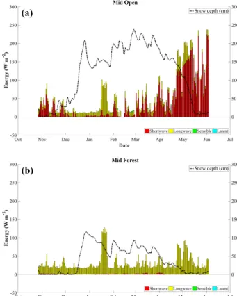
persist (Fig. 4). Not surprising then is the importance of the radiative fluxes for the net energy balance at all sites out-side of the High Open site. Longwave radiation dominates at the Low and Mid Forest sites regardless of elevation or year (Figs. S1–S4 in the Supplement). Snowpack melt response to the increased longwave radiation in the forest from last-ing events can be substantial. For example, at the Mid For-est site during an 8-day mid-January period, longwave ra-diation at the snow surface increased 71 W m−2 (225 % in-crease), while snowmelt response was immediate and sig-nificant, attributed to a reduction of 32 cm (37 %) in snow-pack depth (Fig. 5). During the same period, longwave radi-ation increased 56 W m−2(342 % increase) at the Mid Open
set-Figure 4.Calculated daily mean energy balance in W m−2(solid line) and the range of values (shaded area) for(a)net energy at the snow surface;(b)net solar radiation;(c)net longwave radiation; and(d)net turbulent energy at the snow surface for each site within the ForEST network, WY 2012–WY 2015.
tling attributed to the major snow reduction event in late De-cember. A similar analysis at the High sites shows shortwave radiation driving the snowmelt response to mid-season melt events (Fig. S4). WY 2015 was a historically low year for the Pacific Northwest (Sproles et al., 2017); however, over a 4-day period in early January 2015 a large melt event oc-curred where the High Forest experienced a 37 % reduction in snow depth and the High Open snow depth reduced by 50 % (Fig. S4). Longwave radiation increased 94 % at the Forest site, attributed to 71 % of the total energy budget dur-ing the event. Conversely, the Open site longwave radiation increased 366 %, yet accounted for only 26 % of the total net energy budget, with shortwave radiation at 49 % and the net turbulent flux contributing the rest.
Air temperature is a first-order control in longwave radi-ation calculradi-ation and therefore it is expected that the lower and thus warmer sites will experience a larger percentage of net radiation in the form of longwave radiation. Average monthly air temperatures show that the High Forest site is 1.9 and 1.8◦C cooler during the winter months (DJF) than the Low and Mid Forest sites, respectively (Fig. 6). Colder temperatures reduce the longwave radiation received at the snow surface during the winter months as longwave radia-tion is nonlinearly controlled by air temperature (Eq. 7). The reduced longwave input and lower forest density at the High
Forest site is reflected in the radiation budget where the net longwave energy component is 25 % less than the net long-wave energy at the Low and Mid Forest sites.
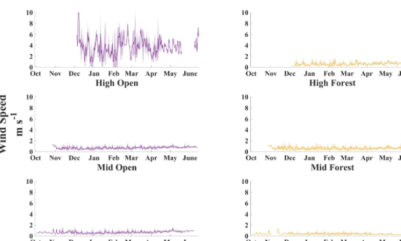
Wind speeds at all sites except at the High Open site are relatively weak and inconsistent, resulting in little turbulent mixing. Sustained (annual average) wind speeds at the High Open site are over 5 times greater than at any other site, with peak daily maxima more than 9 times greater (Fig. 7). At the High Open site high wind speeds occur frequently, while all other sites experience low wind speeds and little variability. Mean winter wind speed for the High Open site is 3.6 m s−1. Mean winter wind speeds for the Low and Mid Open sites are both 0.7 m s−1. The high wind speeds cause instability and subsequent turbulent mixing, resulting in much larger tur-bulent fluxes at the High Open site. Conversely, when wind speeds are low, minimal, if any, mixing occurs, and a de-coupling of the snow surface and the atmosphere can persist. Calculation of the Richardson number (Eq. 13) determines the stability of the atmosphere, and where values are greater than 0.2, this decoupling occurs. Although there is no con-sensus on what threshold this critical value should be, we use a threshold of 0.2 (Raleigh et al., 2013). Over the course of the study theRiBvalue within each cover type at the Low
[image:9.612.50.542.66.348.2]Figure 5.Calculated daily mean energy balance component magnitudes (bars) and the daily measured snow depth (dashed line) for Mid Open(a)and Mid Forest(b)during WY 2013.
2014 the critical value was exceeded 60 % of the time at both the Low sites, 76 and 71 % at the Mid Open and Mid Forest sites, 82 % of the time at the High Forest site, and only 10 % of the time at the High Open site.
Forest structure at the Low and Mid Forest sites is typ-ified by average crown diameters of 9.4 and 6.7 m and av-erage LAIs of 2.4 and 2.7, respectively. At the High Forest site average crown diameter and LAI were measured as 2.8 and 1.1 m, respectively. A multi-layered and randomly dis-tributed forest canopy greatly impacts the amount of solar radiation reaching the forest floor through beam attenuation (Campbell, 1986). Forest canopies provide solar shading as the spring progresses and solar angle increases, intensifying the incoming solar radiation. At the Low and Mid Forest sites
where canopy interception is high, the impact of solar shad-ing becomes less pronounced and snowpack SWE is not pre-served late into the spring. With snowfall magnitude essen-tially the same at the mid and high elevations, we see that the snowpack lasts much longer into the spring at the High Forest site when forest shading has a meaningful effect on reducing solar inputs into the snowpack.
4 Discussion
Figure 6.Boxplot of average monthly air temperature for each site within the ForEST network, WY 2012–WY 2015.
Figure 7.Daily average wind speed (heavy solid line) and the range of wind speeds (shaded area) for each site within the ForEST network, WY 2012–WY 2015.
et al., 2007; Musselman et al., 2008). Multi-layered forest cover and a relatively warm forest increase canopy inter-ception efficiency, resulting in significant reductions in sub-canopy snow accumulation (Storck et al., 2002). While no significant relationship existed between daily air temperature andCIEwithin our study (p >0.005), a threshold behavior
appears to exist where events under 15 cm seem to be highly correlated with CIE. This suggests a nonlinear relationship
[image:11.612.104.497.328.564.2]While few studies in maritime forested environments on the energy balance exist, there is evidence of longwave ra-diation as the dominating term during rain on snow (ROS) events within forests (Berris and Harr, 1987; Mazurkiewicz et al., 2008; Garvelmann et al., 2014). Berris and Harr (1987) showed that longwave radiation accounted for 38–88 % of all ROS event snowmelt. Garvelmann et al. (2014) found that in two ROS events longwave radiation accounted for 55.1 and 38.8 % of the net energy balance, although this may be bi-ased low due to the inability to accurately capture tree trunk temperature. Although Mazurkiewicz et al. (2008) did not differentiate between radiation terms, they found that net ra-diation was the largest contributor to melt. The highly nonlin-ear relationship between air temperature and incoming long-wave radiation formulation is apparent in the net radiation budget analysis. Infrequent cloud-free days and the warm, dense forests of the study area combine to emit a significant amount of longwave radiation to the snow surface (Berris and Harr, 1987; Sicart et al., 2004; Garvelmann et al., 2014). This leads to a positive net snow surface energy balance and mid-winter melt events, most pronounced at the warmer lower el-evation sites. With prolonged exposure to longwave radiation emitted by the canopy and the high efficiency of warm forest canopy interception capabilities, low elevation maritime sub-canopy snowpacks are relatively thin and do not persist long enough into the spring season to benefit from forest shading. This creates a radiative paradox where the longwave radia-tion emitted by dense and relatively warm forest cover ex-ceeds the resulting reduction in shortwave radiation due to forest shading (Sicart et al., 2004; Lawler and Link, 2011; Lundquist et al., 2013). The higher elevation sites experience colder air temperatures, higher wind speeds, and lower for-est density, which combine to decreaseCIEand the impact of
longwave radiation on mid-winter melt events. Furthermore, relatively low ablation rates for the Low and Mid Forest sites suggest that forests do provide some radiative shading during the melt season. However, the benefit of solar shading can only be realized if a sufficient snow cover is present. Other-wise, the effects of reduced solar inputs become secondary and it is the accumulation rate, or more precisely, the effi-ciency of the canopy interception, that is the principle control on the date of snow disappearance.
Here, we considered that wind may have an impact on canopy snow unloading and subsequent increases in sub-canopy snow accumulation. While a seasonal mean presents a general view of the wind environment at each Open site, it masks the variability of wind gusts that can drive snow redistribution. Using the 10 min mean wind speeds better de-picts the wind characteristics that can affect wind redistribu-tion of snow. Pomeroy and Gray (1990) suggest that for wet snow a snow transport wind threshold of 7–10 m s−1 mea-sured at 10 m above the ground surface must be exceeded before any redistribution can occur. Using this threshold, the High Open site measured wind speeds met or exceeded the lower threshold 9.9 % of the entire record and 14.4 % if we
translate measured wind speed toZ =10 m using a simple wind profile power law. This represents a substantial amount of the snow season and enough to suggest that wind redis-tribution is possible. More likely is the wind effect on depo-sition of snowfall. The influence of the forest on the reduc-tion of wind speeds at the high elevareduc-tion sites can lead to preferential deposition within the forest as the wind speeds attenuate. Once snow is deposited onto the ground the wet maritime snow makes it difficult to be redistributed as a re-sult of saltation and suspension. However, the Open site ex-periences high enough sustained wind speeds to effectively redistribute and transport wet maritime snow from the High Open site into the adjacent High Forest site. Although the magnitude of this redistribution of snow from Open to Forest is unknown, it is reasonable to assume that it is not insignif-icant considering the sustained high winds of the High Open environment.
The effects of elevation position within a watershed and forest structure on snow persistence can have serious impli-cations within a warming climate. Sproles et al. (2013) docu-mented a 150 m increase in the elevation of the snow line for every 1◦C temperature increase and showed that projected temperature increases of about 2◦C would shift precipitation at 1500 m from snowfall to a rain–snow mix. If that were to occur, then forests at that elevation, e.g., the High For-est site, that now help maintain late spring snowpacks would likely behave more like the lower elevation forests in which snowmelt occurs earlier than in the Open areas, effectively offsetting any solar shading gains that the forest can provide in the present. Peak SWE and spring runoff would be re-duced at these higher elevations. These high elevation forests could lose their dry season “moisture subsidy” and suffer in-creased moisture stress, with wide-ranging implications for forest and water resource managers.
5 Conclusions
at temperature only. Similarly, Sproles et al., 2013 showed that the lower boundary of the snow zone has little resilience to a warming world. Our paper demonstrates that under-standing the snowpack energy budget is key to understand-ing how forests influence snow accumulation and melt. By quantifying the mechanisms of how vegetation affects sub-canopy snowpack energy balance, the results of this study provide the basis for understanding the sensitivity of mar-itime snowpacks to a changing climate. As climate contin-ues to warm, we anticipate reduced snow accumulation at elevations where snowfall shifts to a rain–snow mix, and amplified sub-canopy melt rates due to longwave radiative heating in warmer forests, thereby reducing overall forest snow retention. However, higher elevation colder sites with a less dense forest can mitigate that to some extent by retain-ing the snowpack longer through lower relative forest long-wave emission and lower canopy interception. A key finding within this study is that throughout the study duration, one that saw high inter-annual snowfall variability, a definitive pattern emerged within the energy budget and snowpack dy-namics across the network. The energy budget format that we present here goes beyond the temperature only approach while getting at the causal effects and mechanisms of the challenge of vegetation–snowpack interactions for a warm-ing climate.
While these results are focused on the Oregon Cascades, they have broader implications for other relatively warm forested snow environments with elevation gradients, such as parts of the California Sierra Nevada, the Japanese and European Alps, and the Pyrenees (Lundquist et al., 2013). These results will aid in improving parameterizations of snow–forest interactions in physically based snow hydrol-ogy models and land surface models. Additionally, as cli-mate change alters regional snow deposition patterns across the western US, our findings are applicable to land and wa-ter managers, seeking to improve forest snowpack retention, enhance forest health, and improve streamflow forecasting. This study demonstrates the value of plot-scale snow–forest process studies for improving our understanding of the for-est effects on snowpack evolution. Future work will focus on a multi-scale approach that incorporates remote sensing and snow hydrology modeling to identify forest structure met-rics that are well suited to accurately modeling snow–forest interactions. Such an approach will allow the snow commu-nity to quantify the improvement of snow–forest interactions across spatial scales and enhance model prediction for land-scape and regional applications.
Data availability. The data used in this study are freely available online from the Oregon State University ScholarsArchive: https://ir. library.oregonstate.edu/xmlui/handle/1957/59984 (Roth and Nolin, 2016).
The Supplement related to this article is available online at https://doi.org/10.5194/hess-21-5427-2017-supplement.
Competing interests. The authors declare that they have no conflict of interest.
Acknowledgements. This research was made possible by funding provided by the National Science Foundation (EAR 1039192) and from a NASA Earth Science Student Fellowship (16-EARTH16F-0426). We thank Willamette National Forest for providing access permits for the ForEST network. Additional material support was provided by the Western Ecology Division office of the Environmental Protection Agency, with special thanks to Ron Waschmann. We thank the many student interns who assisted in snow surveys and site maintenance.
Edited by: Jan Seibert
Reviewed by: three anonymous referees
References
Alados-Alboledas, L., Vida, J., and Olmo, F. J.: The estimation of thermal atmospheric radiation under cloudy skies, Int. J. Climate, 15, 107–116, 1995.
Allen, C. D., Macalady, A. K., Chenchouni, H., Bachelet, D., Mc-Dowell, N., Vennetier, M., Kitzberger, T., Rigling, A., Breshears, D. D., Hogg, E. H., Gonzalez, P., Fensham, R., Zhang, Z., Castro, J., Demidova, N., Lim, J. H., Allard G., Running, S. W., Semerci, A., and Cobb, N.: A global overview of drought and heat-induced tree mortality reveals emerging climate change risks for forests, Forest Ecol. Manag., 259, 660–684, 2010.
Anderson, E. A.: A point energy balance and mass balance model of snow cover, Silver Spring, Md., US DOC NOAA, Tech Rpt., NWS 19, 1976.
Andreadis, K. M., Storck, P., and Lettenmaier, D. P.:
Mod-eling snow accumulation and ablation processes in
forested environments, Water Resour. Res., 45, 1–13, https://doi.org/10.1029/2008WR007042, 2009.
Andreas, E. L.: A new method of measuring the snow-surface temperature, Cold Reg. Sci. Technol., 12, 139–156, https://doi.org/10.1016/0165-232X(86)90029-7, 1986.
Andreas, E. L.: Parameterizing scalar transfer
over snow and ice: a review, J.
Hydromete-orol., 3, 417–432,
https://doi.org/10.1175/1525-7541(2002)003<0417:PSTOSA>2.0.CO;2, 2002.
Berris, S. N. and Harr, R. D.: Comparative snow accumulation and melt during rainfall in forested and clear-cut plots in the western Cascades of Oregon, Water Resour. Res., 23, 135–142, https://doi.org/10.1029/WR023i001p00135, 1987.
Boon, S.: Snow ablation energy balance in a dead forest stand, Hy-drol. Process., 23, 2600–2610, https://doi.org/10.1002/hyp.7246, 2009.
Brooks, J. R., Wigington, P. J., Phillips, D. L., Comeleo, R., and Coulombe, R.: Willamette River Basin surface water isoscape (δ18O and δ2H): temporal changes of source water within the river, Ecosphere, 3, 39, https://doi.org/10.1890/es11-00338.1, 2012.
Brutsaert, W.: On a derivable formula for long-wave radiation from clear skies, Water Resour. Res., 11, 742–744, 1975.
Brutsaert, W.: Evaporating Into the Atmosphere: Theory, History, and Applications, D. Reidel Publ. Co., Dordrecht, 1982. Campbell, G. S.: Extinction coefficients for radiation in plant
canopies calculated using an ellipsoidal inclination angle distri-bution, Agr. Forest Meteorol., 36, 317–321, 1986.
Choat, B., Jansen, S., Brodribb, T. J., Cochard, H., Delzon, S., Bhaskar, R., Bucci, S. J., Field, T. S., Gleason, S. M., Hacke, U. G., Jacobsen, A. L., Lens, F., Maherali, H., Martinez-Vilalta, J., Mayr, S., Mencuccini, M., Mitchell, P. J., Nar-dini, A., Pittermann, J., Pratt, R. B., Sperry, J. S., Westoby, M., Wright, I. J., and Zanne, A. E.: Global convergence in the vul-nerability of forests to drought, Nature, 491, 752–755, 2012. Crawford, T. M. and Duchon, C. E.: An improved parameterization
for estimating effective atmospheric emissivity for use in calcu-lating daytime downwelling longwave radiation, J. Appl. Meteo-rol., 48, 474–480, 1999.
Dai, A.: Increasing drought under global warming in ob-servations and models, Nat. Clim. Change, 3, 52–58, https://doi.org/10.1038/nclimate1633, 2013.
Derby, R. W. and Gates, D. M.: The temperature of tree trunks – calculated and observed, Am. J. Bot., 53, 580–587, 1966. Dickerson-Lange, S. E., Lutz, J. A., Martin, K. A., Raleigh, M. S.,
Gersonde, R., and Lundquist, J. D: Evaluating observa-tional methods to quantify snow duration under diverse forest canopies, Water Resour. Res., 15, 1203–1224, https://doi.org/10.1002/2014WR015744, 2015.
Dilley, A. C. and O’Brien, D. M.: Estimating downward clear sky long-wave irradiance at the surface from screen temperature and precipitable water, Q. J. Roy. Meteor. Soc., 124, 1391–1401, 1998.
Elder, K., Dozier, J., and Michaelsen, J.: Snow accumulation and distribution in an alpine watershed, Water Resour. Res., 27, 154– 1552, 1991.
Elder, K., Rosenthal, W., and Davis, R. E.: Estimating the spatial distribution of snow water equivalence in a montane watershed, Hydrol. Process., 12, 1793–1808, 1998.
Ellis, C. R., Pomeroy, J. W., and Link, T. E.: Modeling in-creases in snowmelt yield and desynchronization resulting from forest gap-thinning treatments in a northern moun-tain headwater basin, Water Resour. Res., 49, 936–949, https://doi.org/10.1002/wrcr.20089, 2013.
Elzinga, C. L., Salzer, D. W., and Willoughby, J. W.: Measuring and Monitoring Plant Populations, USDI Bureau of Land Man-agement Technical Reference 1730-1, National Business Center, Denver, CO, 1998.
Essery, R., Pomeroy, J. W., Ellis, C., and Link, T. E.: Modeling longwave radiation to snow beneath forest canopies using hemi-spherical photography or linear regression, Hydrol. Process., 22, 2788–2800, https://doi.org/10.1002/hyp.6930, 2008.
Flerchinger, G. N., Xaio, W., Marks, D., Sauer, T. J., and Yu, Q.: Comparison of algorithms for incoming atmo-spheric long-wave radiation, Water Resour. Res., 45, W03423, https://doi.org/10.1029/2008WR007394, 2009.
Frazer, G., Canham, C., and Lertzman, K.: Gap Light Analyzer (GLA): Imaging Software to Extract Canopy Structure and Gap Light Transmission Indices from True-Colour Fisheye Pho-tographs: User’s Manual and Program Documentation, Simon Fraser University, Burnaby, BC, https://doi.org/10.1016/S0168-1923(01)00274-X, 1999.
Friesen, J., J. Lundquist, J., and Van Stan, J. T.: Evolution of forest precipitation water storage measurement methods, Hydrol. Pro-cess., 29, 2504–2520, https://doi.org/10.1002/hyp.10376, 2014. Gary, H. L.: Snow accumulation and snowmelt as influenced by
a small clearing in a lodgepole pine forest, Water Resour. Res., 10, 348–353, https://doi.org/10.1029/WR010i002p00348, 1974. Garvelmann, J., Pohl, S., and Weiler, M.: Variability of observed en-ergy fluxes during rain-on-snow and clear sky snowmelt in a mid-latitude mountain environment, J. Hydrometeorol., 15, 1220– 1236, 2014.
Geddes, C. A., Brown, D. G., and Farge, D. B.: Topography and Vegetation as Predictors of Snow Water Equivalent Across the Alpine Treeline Ecotone at Lee Ridge, Glacier National Park, Montana, USA, Arct. Antarct. Alp. Res., 37, 197–205, 2005. Gleason, K. E. and Nolin, A. W.: Charred forests accelerate snow
albedo decay: parameterizing the post-fire radiative forcing on snow for three years following fire, Hydrol. Process., 197–205, https://doi.org/10.1002/hyp.10897, 2016.
Gleason, K. E., Nolin, A. W., and Roth, T. R.: Charred forests in-crease snowmelt: effects of burned woody debris and incoming solar radiation on snow ablation, Geophys. Res. Lett., 40, 4654– 4661, https://doi.org/10.1002/grl.50896, 2013.
Gleason, K. E., Nolin, A. W., and Roth, T. R.: Developing a representative snow-monitoring network in a forested moun-tain watershed, Hydrol. Earth Syst. Sci., 21, 1137–1147, https://doi.org/10.5194/hess-21-1137-2017, 2017.
Gray, D. M.: Snow accumulation and distribution, in: Proceedings, Modelling of Snow Cover Runoff, edited by: Colbeck, S. C., and Ray, M., US Army Cold Regions Research and Engineering Lab-oratory, Hanover, NH, 3–33, 1979.
Hardy, J. P., Marks, D., Link, T., and Koenig, G.: Variability of the below canopy thermal structure over snow, Eos Trans. AGU, Fall Meet Suppl., 85(47): F448, 2004.
Harpold, A. A., Biederman, J. A., Condon, K., Merino, M., Kor-gaonkar, Y., Nan, T., Sloat, L. L., Ross, M., and Brooks, P. D.: Changes in snow accumulation and ablation following the Las Conchas Forest Fire, New Mexico, USA, Ecohydrology, 7, 440– 452, https://doi.org/10.1002/eco.1363, 2013.
Harpold, A. A., Molotch, N. P., Musselman, K. N., Bales, R. C., Kirchner, P. B., Litvak, M., and Brooks, P. D.: Soil moisture response to snowmelt timing in mixed-conifer subalpine forests, Hydrol. Process., 29, 2782–2798, https://doi.org/10.1002/hyp.10400, 2015.
Hatfield, J. L., Reginato, R. J., and Idso, S. B.: Comparison of long-wave radiation calculation methods over the United States, Water Resour. Res., 19, 285–288, 1983.
https://doi.org/10.1002/(SICI)1099-1085(199808/09)12:10/11<1611::AID-HYP684>3.0.CO;2-4, 1998.
Homer, C., Dewitz, J., Fry, J., Coan, M., Hossain, N., Larson, C., Herold, N., McKerrow, A., VanDriel, J. N., and Wickham, J.: Completion of the 2001 National Land Cover Database for the Conterminous United States, Photogramm. Eng. Rem. S., 73, 337–341, 2007.
Inoue, A., Yamamoto, K., Mizoue, N., and Kawahara, Y.: Calibrat-ing view angle and lens distortion of the Nikon fish-eye converter FC-E8, J. Forest Res., 9, 17, https://doi.org/10.1007/s10310-003-0073-8, 2004.
Jefferson, A., Nolin, A., Lewis, S., and Tague, C.: Hydrogeo-logic controls on streamflow sensitivity to climate variation, Hy-drol. Process., 22, 4371–4385, https://doi.org/10.1002/hyp.7041, 2008.
Jost, G., Weiler, M., Gluns, D. R., and Alila, Y.: The in-fluence of forest and topography on snow accumulation and melt at the watershed-scale, J. Hydrol., 347, 101–115, https://doi.org/10.1016/j.jhydrol.2007.09.006, 2007.
Kustas, W. P., Rango, A., and Uijlenhoet, R.: A simple energy bud-get algorithm for the snowmelt runoff model, Water Resour. Res., 30, 1515–1527, 1994.
Lawler, R. R. and Link, T. E.: Quantification of incoming all-wave radiation in discontinuous forest canopies with applica-tion to snowmelt predicapplica-tion, Hydrol. Process., 25, 3322–3331, https://doi.org/10.1002/hyp.8150, 2011.
Lhomme, J. P., Vacher, J. J., and Rocheteau, A.: Estimating down-ward long-wave radiation on the Andean Altiplano, Agr. Forest Meteorol., 145, 139–1482, 2007.
Link, T. E. and Marks, D.: Distributed simulation of snowcover mass- and energy-balance in the boreal forest, Hydrol. Process., 13, 2439–2452, 1999.
Liston, G. E. and Sturm, M.: A snow-transport model for complex terrain, J. Glaciol., 44, 498–516, 1998.
López-Moreno, J. I. and Latron, J.: Influence of canopy density on snow distribution in a temperate mountain range, Hydrol. Pro-cess., 22, 117–126, 2008.
López-Moreno, J. I. and Stähli, M.: Statistical analysis of the snow cover variability in a subalpine watershed: assessing the role of topography and forest interactions, J. Hydrol., 348, 379–394, 2008.
Lundquist, J. E., Dickerson-Lange, S. E., Lutz, J. A., and Cristea, N. C.: Lower forest density enhances snow retention in regions with warmer winters: a global framework developed from plot-scale observations and modeling, Water Resour. Res., 49, 6356–6370, https://doi.org/10.1002/wrcr.20504, 2013. Lyon, S. W., Troch, P. A., Broxton, P. D., Molotch, N. P.,
and Brooks, P. D.: Monitoring the timing of snowmelt and the initiation of streamflow using a distributed net-work of temperature/light sensors, Ecohydrology, 1, 215–224, https://doi.org/10.1002/eco.18, 2008.
Marks, D. and Dozier, J.: Climate and energy exchange at the snow surface in the alpine region of the Sierra Nevada, 2, Snow cover energy balance, Water Resour. Res., 28, 3043–3054, https://doi.org/10.1029/92WR01483, 1992.
Marks, D., Kimball, J., Tingey, D., and Link, T. E.: The sen-sitivity of snowmelt processes to climate conditions and forest cover during rain-on-snow: a case study of the 1996 Pacific Northwest flood, Hydrol. Process., 12, 1569–1587,
https://doi.org/10.1002/(SICI)1099-1085(199808/09)12:10/11, 1998.
Martin, K. A., Van Stan, J. T., Dickerson-Lange, S. E., Lutz, J. A., Berman, J. W., Gersonde, R., and Lundquist, J. D.: Development and testing of a snow interceptometer to quantify canopy wa-ter storage and inwa-terception processes in the rain/snow transition zone of the North Cascades, Washington, USA, Water Resour. Res., 49, 3243–3256, https://doi.org/10.1002/wrcr.20271, 2013. Mazurkiewicz, A. B., Callery, D. G., and McDonnell, J. J.:
Assess-ing the controls of the snow energy balance and water available for runoff in a rain-on-snow environment, J. Hydrol., 354, 1–14, https://doi.org/10.1016/j.jhydrol.2007.12.027, 2008.
McCabe, G. J. and Clark, M. P.: Trends and variability in snowmelt runoff in the western United States, J. Hydrometeorol., 6, 476– 482, 2005.
Melloh, R. A., Hardy, J. P., Bailey, R. N., and Hall, T.: An efficient snow albedo model for the open and subcanopy, Hydrol. Pro-cess., 16, 3571–3584, https://doi.org/10.1002/hyp.1229, 2002. Miller, J. D., Safford, H. D., Crimmins, M. A., and Thode, A. E.:
Quantitative evidence for increasing forest fire severity in the Sierra Nevada and southern Cascade Mountains, California and Nevada, USA, Ecosystems, 12, 16–32, 2009.
Moeser, D., Stähli, M., and Jonas, T.: Improved snow in-terception modeling using canopy parameters derived from airborne LiDAR data, Water Resour. Res., 51, 5041–5059, https://doi.org/10.1002/2014WR016724, 2015.
Molotch, N. P. and Bales, R. C.: SNOTEL representativeness in the Rio Grande headwaters on the basis of physiographics and remotely sensed snow cover persistence, Hydrol. Process., 20, 723–739, 2006.
Moore, R. D.: On the use of bulk aerodynamic formulae over melt-ing snow, Nord. Hydrol., 14, 193–206, 1983.
Moritz, M. A., Parisien, M. A., Batllori, E., Krawchuk, M. A., Van Dorn, J., Ganz, D. J., and Hayhoe, K.: Climate change and disruptions to global fire activity, Ecosphere, 3, 49, https://doi.org/10.1890/ES11-00345.1, 2012.
Morris, E.: Turbulent transfer over snow and ice, J. Hydrol., 105, 205–223, 1989.
Mote, P. W.: Climate-driven variability and trends in mountain snowpack in western North America, J. Climate, 19, 6209–6220, 2006.
Musselman, K., Molotch, N. P., and Brooks, P. D.: Effects of vegetation on snow accumulation and ablation in a mid-latitude sub-alpine forest, Hydrol. Process., 22, 2767–2776, https://doi.org/10.1002/hyp.7050, 2008.
Musselman, K., Clark, M. P., Liu, C., Ikeda, K., and Rasmussen, R.: Slower snowmelt in a warmer world, Nat. Clim. Change, 7, 214– 220, https://doi.org/10.1038/NCLIMATE3225, 2017.
Nolin, A. W. and Daly, C.: Mapping “at risk” snow in the Pacific Northwest, J. Hydrometeorol., 7, 1164–1172, https://doi.org/10.1175/JHM543.1, 2006.
O’Halloran, T. L., Law, B. E., Goulden, M. L., Wang, Z., Barr, J. G., Schaaf, C., Brown, M., Fuentes, J. D., Göckede, M., and Black, A.: Radiative forcing of natural forest disturbances, Glob. Change Biol., 18, 555–565, 2012.
Oke, T. R.: Boundary Layer Climates, Routledge, 2nd edition, Methuen, London, vol. 8, 262–303, 1987.
Pomeroy, J. W., Marsh, P., and Gray, D. M.: Application of a dis-tributed blowing snow model to the Arctic, Hydrol. Process., 11, 1451– 1464, 1997.
Pomeroy, J. W., Gray, D. M., Hedstrom, N. R., and Janow-icz, J. R.: Prediction of seasonal snow accumulation in cold climate forests, Hydrol. Process., 16, 3543–3558, https://doi.org/10.1002/hyp.1228, 2003.
Raleigh, M. S., Landry, C. C., Hayashi, M., Quinton, W. L., and Lundquist, J. D.: Approximating snow surface temperature from standard temperature and humidity data: new possibilities for snow model and remote sensing evaluation, Water Resour. Res., 49, 8053–8069, https://doi.org/10.1002/2013WR013958, 2013. Roth, T. R. and Nolin, A. W.: Willamette Water 2100 Forest
El-evational Snow Transect (ForEST) Project: dataset available at https://ir.library.oregonstate.edu/xmlui/handle/1957/59984 (last access: 19 July 2017), https://doi.org/10.7267/N900001K, 2016. Ryan, W. A., Doesken, N. J., and Fassnacht, S. R.: Eval-uation of ultrasonic snow depth sensors for US snow
measurements, J. Atmos. Ocean. Tech., 25, 667–684,
https://doi.org/10.1175/2007JTECHA947.1, 2008.
Schmidt, R. A. and Gluns, D. R.: Snowfall interception on branches of three conifer species, Can. J. Forest Res., 21, 1262–1269, 1991.
Sicart, J. E., Essery, R. L. H., Pomeroy, J. W., Hardy, J., Link, T. E., and Marks, D.: A sensitivity study of daytime net radiation during snowmelt to forest canopy and atmospheric conditions, J. Hydrometeorol., 5, 774–784, https://doi.org/10.1175/1525-7541(2004)005<0774:ASSODN>2.0.CO;2, 2004.
Spracklen, D. V., Mickley, L. J., Logan, J. A., Hudman, R. C., Yevich, R., Flannigan, M. D., and Westerling, A. L.: Im-pacts of climate change from 2000 to 2050 on wildfire ac-tivity and carbonaceous aerosol concentrations in the west-ern United States, J. Geophys. Res.-Atmos., 114, D20301, https://doi.org/10.1029/2008JD010966, 2009.
Sproles, E. A., Nolin, A. W., Rittger, K., and Painter, T. H.: Cli-mate change impacts on maritime mountain snowpack in the Oregon Cascades, Hydrol. Earth Syst. Sci., 17, 2581–2597, https://doi.org/10.5194/hess-17-2581-2013, 2013.
Sproles, E. A., Roth, T. R., and Nolin, A. W.: Future snow? A spatial-probabilistic assessment of the extraordinarily low snowpacks of 2014 and 2015 in the Oregon Cascades, The Cryosphere, 11, 331–341, https://doi.org/10.5194/tc-11-331-2017, 2017.
Stähli, M. and Gustafsson, D.: Long-term investigations of the snow cover in a subalpine semi-forested catchment, Hydrol. Process., 20, 411–428, 2006.
Storck, P., Lettenmaier, D. P., and Bolton, S.: Measurement of snow interception and canopy effects on snow accumulation and melt in a mountainous maritime climate, Oregon, United States, Water Resour. Res., 38, 1223, https://doi.org/10.1029/2002WR001281, 2002.
Varhola, A., Coops, N. C., Weiller, M., and Moore, R. D.: For-est canopy effects on snow accumulation and ablation: an in-tegrative review of empirical result, J. Hydrol., 392, 219–233, https://doi.org/10.1016/j.jhydrol.2010.08.009, 2010.
Vose, J. M., Miniat, C. F., Luce, C. H., Asbjornsen, H., Cald-well, P. V., Campbell, J. L., Grant, G. E., Isaak, D. J., Loheide II, S. P., and Sun, G.: Ecohydrological implications of drought for forests in the United States, For. Ecol. Manage., 380, 335– 345, https://doi.org/10.1016/j.foreco.2016.03.025, 2016. Westerling, A. L., Hildago., H. G., Cayan, D. R., and
Swetnam, T. W.: Warming and earlier spring increase in western US forest wildfire activity, Science, 313, 940, https://doi.org/10.1126/science.1128834, 2006.
Westerling, A. L., Turner, M. G., Smithwick, E. A. H., Romme, W. H., and Ryan, M. G.: Continued warming could transform Great Yellowstone fire regimes by mid-21st century, P. Natl. Acad. Sci. USA, 108, 32, 13165–13170, 2011.