Floods In Jammu & Kashmir –With Special Reference To 2014
UmmarAhad
Govt. College For Women, M.A. Road, Srinagar.
Abstract: -On September, 7, 2014, the river Jhelum, Jammu and Kashmir, was inundated by flood water everywhere smashing everything in its way. The flood waters, triggered by seven days of unusual heavy rains, caused havoc in the region. They washed away crops, orchards and devastated housing and business infrastructure. The main brunt of the ferocious floods, described as the “extreme of the extreme”, was borne by Srinagar city - the city known as the summer capital of Kashmir - home to around two million people. Many remained trapped on roof tops, evading flood waters, for weeks. All major hospitals, shops and pharmacies were inundated and roads were washed away, plunging the Kashmir valley into chaos and causing unimaginable suffering. More than half a million people, most of them in Srinagar city, got trapped in their houses as the city was submerged under 18 feet water for more than three weeks. It was a nightmarish experience within few hours the whole localities got submerged and no way to flee.
Keywords: Disaster; Climate change; Floods; Deluge; Paradise;Inundation; Hazard.
INTRODUCTION
A flood is a situation where water from the water bodies overflows on the adjacent dry land making the surroundings inundated. Flood risk can be defined as the combination of the probability of a flood event and its potential adverse consequences (Smith 1996; Sayers et al. 2002; UNISDR 2009). As both aspects of risk— hazard and vulnerability—are non-stationary, flood risk is a ‗‗dynamic entity‘‘ (Merz et al. 2010). This changeable characteristic of flood risk is emphasized in the EU Floods Directive (2007/60/EC), which specifies that ‗‗…human
immediate effect on flood risk, practical findings concerning the climate change-related influences are less clear. According to the fifth IPCC assessment report (Hartmann et al. 2013), floods larger than recorded since the twentieth century occurred during the past five centuries in Asia , northern and central Europe, the western Mediterranean region and eastern Africa‘‘. For Asia, although there is some evidence of a overall increase in extreme precipitation, no conclusive evidence is available for climate-related trends of extreme flow for the future (Barredo 2007, 2009; Kundzewicz 2012; Madsen et al. 2014). A comprehensive study of climate change impacts on flood frequency shows no clear climate signal (Nachtnebel et al. 2014). Blo¨schl et al. (2011), on the other hand, report on the basis of several if–then scenario simulations that future changes for flood peaks with a return period of 100 years are in the range of -4 to 10 %. Although no conclusive evidence and projections exist concerning changes in flood frequency and magnitude, it is clear that climate change is influencing and will further influence
components of the Himalayan hydrological cycle, e.g. due to higher temperatures or rising snowlines.
Study Area
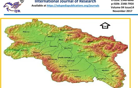
J&K is located in the northern part of the Indian subcontinent in the vicinity of the Karakoram and Western Himalayan mountain ranges. The state is a landlocked Himalayan region, surrounded by Pakistan, Afghanistan and China from west to east and by Punjab and Himachal Pardesh states to its south. There is a sharp rise in altitude from 1000 to 28,250 ft(amsl)within the state‘s four degree of latitude. The foothills ofthe Himalaya, rising from about 2000–7000 ft (600– 2100 m), form the outer and inner zones. The PirPanjalRange constitutes the first (southernmost) mountain rampart associated with the Himalaya in the state and is the westernmost of the Lesser Himalayas. The Vale of Kashmir is a deep, asymmetric basin lying between the PirPanjal Range and the western end of the Great Himalaya at an average elevation of 5300 ft (1620 m).Fig. 1.
Fig. 1. Study Area
For the monsoon season, Indian Meteorological Department (IMD), New Delhi publishes, in its weekly weather reports, daily rainfall for each day of the season as recorded at about 2600 rain-gauge stations comprising IMD‘s own network, automatic weather stations (AWS) network ofIMD, state rain-gauge networks, etc. The normal daily and monthly rainfall over various stations/districts has been calculated using average data for the period 1970–2000 for which long-term records are available. DailyIndian precipitation analysis from a merges of rain-gaugedata with the TRMM TMPA satellite-derived rainfall estimates during 3–7 September 2014 have been used to show rainfall over the J&K region. The rainfall rates have been calculated for some of the stations using hourly rainfall recorded in AWS installed in J&K.
The Jehlum and its Tributaries
The Kashmir valley, which forms a composite Jhelum basin, has a fairly well established drainage system headed by the Jhelum, the main channel of drainage. The river is initially formed by the confluence of 3 streams, the Arapal, the Bringi and the Sandran which rise at the south-east end of the valley. The river has shaped up the ecology, economy and the life style of the inhabitants of the valley. The whole length of the Jhelum from its source from Verinagto Baramulla is 150 miles. The drop of the river is 18 m in 113 kms. The Jhelum itself rises from the Pirpanjal range near Verinag, a spring at the bottom of high scarp of a mountain spur at the upper end of the Kashmirvalley. Below Srinagar it receives the Sindh and beyond, the Wular Lake, thePohru stream joins it from the Lolab valley. AfarBaramulla the Jhelum leaves the fertile banks of the valley and rushes head long a deep gorge between lofty mountains. AtMuzaffarabad, the Kishanganga joins the Jhelum from its heights. Lower down, the river borders the outlying spurs of the salt range and finally emerges upon the plains near the city of Jhelum in the West Pakistan about 402 kms from
Fig 2.Jehlum Basin with its Catchment source: - JKENVIS
HISTORY OF FLOODS IN J&K
Jammu and Kashmir has a long history of flooding. Floods in the stateare linked to the Jhelum River and it has history of crossing the danger mark and thereby inundating the ‗Valley‘. And history was once again ferociously repeated in 2014, the statehad seen an unprecedented amount of rainfall, resulting in its worst floodssince 1959. While the scale of devastation caused by these floods wasnothing short of massive. The Valley, along with the Jammu region has, over the time witnessedfloods occurring at regular intervals.―Many disastrous floods are noticed in vernacularhistories, but the greatest was the terrible inundation which followed theslipping of the KhadanyarMountains below Baramulla in AD 879. Thechannel of the Jhelum river was blocked and a large part of the valley wassubmerged‖ (Lawrence, 1895). The other major flood to affect Kashmir happened in 1841,which Lawrence notes, ―caused much damage to life and property.‖However, the first flood of devastating proportions to hit the state
Mohammad was quoted as saying that, ―the floods recorded in Jammu and Kashmir were the highest ever recorded in the state, and that the damage caused by them was colossal.‖ Two years later, in July 1959, the state witnessed yet another massive ―glacial‖ flood, perhaps worst ever at the time, when four days of incessant rains lashed the valley and Srinagar, triggering floods in the Jhelum. While the state did witness floods thereafter in the following three decades, the one in 1992 was unprecedented in terms of its fury. Recording its heaviest rainfall since 1959, the 1992 floods were most devastating, purely in terms of casualties. According to print media reports from 1992, over 200 people lost their lives and the floods left over 60,000 people marooned in several north-western border districts. Floods were witnessed in 1996 and more recently in 2006 as well. Massive floods were caused by a cloudburst in the Leh-Ladakh region of Jammu and Kashmir, which occurred on 6 August 2010, produced flashfloods in the area after a night of heavy downpour. While it only lasted for half an hour, the devastation caused by the cloudburst was enormous. It destroyed many buildings in the city of Leh.
FLOODS-2014
Jammu & Kashmir experienced the worst floods in the past 60 years was that of September 2014 due to unprecedented and extremerains. The Jhelum River and its tributaries were in freshet and infusedhavoc and huge damage in various districts of Kashmir Valley. The Jammu and Kashmir state experienced catastrophic rainfall from 1stto7thof September. On September 4th,
2014 J&Kexperienced 30hour long rainfall that has broken the record of manydecades; the major parts of the state recorded an average of more thansome aspects of catastrophic rain fall in J&K. Some parts of the stateexperienced more than 650mm of rainfall in 3 days. Even moderaterainfall was also recorded in Ladakh region. September was notconsidered rainy
season in the Kashmir and Ladakh region, butin 2014 both these region had recorded moderate to heavy rainfall.
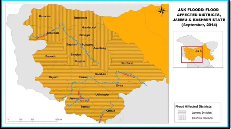
The areas affected by floods were mostly districts, including Anantnag, Pulwama, Baramullaand Srinagar. These are in rain-shadow region of the PirPanjal Range of the lesser Himalaya and receive less than 300 mm rainfall during the monsoon season. The total cumulative rainfall during the week from 4–10 September 2014 over these districts was 309 (Anantnag), 256 (Baramulla), 243 (Pulwama) and 148 mm (Srinagar), which is higher than the average rainfall for the entire monsoon season in these districts. The continuous heavy rains were due to interaction between the westward-moving monsoon low and the eastward-moving deep trough in the mid-latitude westerlies.
Unprecedented rainfall
7thSeptember 2014 catchment-wise, it was
observed that Lidder Catchment received maximum amount of rainfall i.e. 277mm with adjoining catchments in South Kashmir viz-a-via Arpal, Bringi, Kuthar, Sandran, Vishaw, alsoreceiving rainfall above 200mm.The rainfall data collected from Metrological department srinagarfrom 28th August to 10th September 2014
for Jammu and Kashmir also revealed that actual rainfall received (1645mm) in South Kashmir
area was way above normal (124.9mm) rainfall. (Anantnag = 402.3mm, Kulgam= 540.5mm, Shopain = 406mm, Pulwama = 292.7mm) was way above normal (Anantnag = 32.9mm, Kulgam = 42.9mm, Shopain = 29.2mm, Pulwama = 19.9) rainfall (Table -1).It is evident from the results that South Kashmir region received the maximum amount of rainfall during this period causing massive floods in Srinagar and its adjoining areas.
Table-1: Rainfall data during two weeks in Jammu and Kashmir (Source IMD)
28 aug-03sep, 2014 04aug-10sep,
2014 Region/ District Actual (mm) Normal (mm)
Cat. Actual (mm)
Normal (mm)
Cat.
J&K 43.2 27.9 E 267.7 30.0 E
Anantnag 93.2 15.6 E 309.1 17.3 E
Budgam 35.8 8.4 E 76.7 19.5 E
Bandipora * 9.5 * * 10.3 *
Baramula 25.6 13.3 E 255.9 16.1 E
Ganderbal 91.2 9.2 E 32.6 9.8 E
Kulgam 80.3 19.3 E 460.2 23.6 E
Kupwara 7.6 11.7 D 129.2 6.2 E
Pulwama 50.0 6.5 E 242.7 13.4 E
Shopian 58.0 17.8 E 348.0 11.4 E
Srinagar 43.5 9.2 E 148.0 9.8 E
Cat:-Category E:-Excess, D:- Deficit
During the previous recorded floods on the Jhelum were almost 100,000 cusecs of discharge recorded at Sangam and about 80,000 cusecs recorded during the 1928 floods. There are no reliable discharge statistics available for the 1959 floods though some reports suggest that the discharge was almost 100, 000 cusecs at Sangam. While as, during the 2014 floods discharge at Sangam was highest ever recorded on 6th
September 1,35,000 cusecs. This figure doesn‘t include the breachesof river Jehlum(I&FC). The flood inflow was more than the combined carrying capacity of Jehlum and flood channel despite the natural breaches of huge size at Kandizal, Chursu, Lelhar, Marwal, etc. The data
clearly reveals the magnitude of September 2014 floods. The carrying capacity of Jehlum in Srinagar city is about 35,000 cusecs and another 15,000 in the supplementary channel. Unless the flood basins which stand encroachedupon are restored to cater to the surplus flow besides taking some other measures, the city of Srinagar will continue to be under the threat during the flood fury in future.
Spatial Magnitude of Flood Inundation
missing. The flood inundationthough of varying nature as for as spatial extent is concernedwas recorded as per the data given in table 3, during this flood event. It wascalculated that about 557
km2, which constitutes about 3.5% of the Kashmir Valleys geographical area, was inundated due to flooding.(table 2).
Table-2: Table showing extent of inundation from 07-25 September, 2014 S.No. Date Area(km2)
1. 7TH September 2014 346.7* 2. 8TH September 2014 370.6 3. 9TH September 2014 361.2 4. 10TH September 2014 358.6 5. 12TH September 2014 338.6 6. 15TH September 2014 312.3 7. 17TH September 2014 291.7 8. 19TH September 2014 282.9 9. 21ST September 2014 271.3 10. 25TH September 2014 251.9
As per the Govt. Records
District wise inundation of Kashmir Valley
Unprecedented rainfall led to widespread flooding in the Kashmir valley. Flood waters breached embankments in many low-lying areas in Kashmir, including the capital Srinagar.
Jhelum and all its tributaries were flowing above danger mark. The worst affected districts were Srinagar, Anantnag,Bandipora,Baramulla, Pulwama, Ganderbal, Kulgam, Budgam (Table 3).
Table-3: District-wise inundation of Kashmir Valley
S.NO. DISTRICT AREA (km2)
1 Anantnag 43
2 Bandipora 143
3 Baramulla 89
4 Budgam 54
5 Ganderbal 6
6 Kulgam 15
7 Pulwama 102
8 Srinagar 100
Land use/Land cover
As above mentioned the major districts which were inundated during the flood,revealed the following landuse,landcover categories deluged with their areal extent (table 4).
Table-4: Land use/land cover classes under flood inundation.
S.No. LAND USE/LAND COVER AREA (km2)
1 Agriculture 436
2 Horticulture 23
3 Built-up 69
4 Forests 3
5 Wastelands 19
6 Others 2
Total 552
Flood Duration
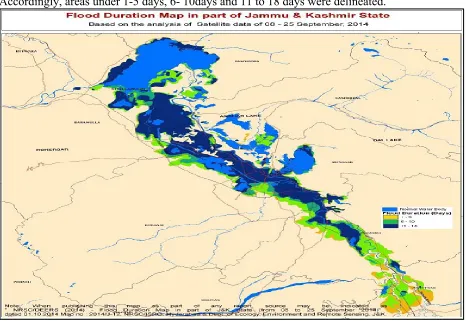
The flood waters isolated several areas in the valley and many villages were drowned by flood water for several days. About 287 villages were affected by floods as on 25 September 2014. The Flood duration/persistence map was prepared to analyze the stay period of flood water in various areas. Accordingly, areas under 1-5 days, 6- 10days and 11 to 18 days were delineated.
Images showing pre and post flood situation from Google Crisis have been used below to show extent of inundation across various location in and around Srinagar city. High-resolution datafrom world view 2 satellites from Digital Globe has efficiently captured flood.
Plate 1
Plate 2
Pre and post flood- Srinagar Railway Station Nowgam..
Plate 3
POSSIBLE CAUSES OF FLOOD
Unexpected and unprecedented precipitation can be defined in terms of number of rainy days if it exceeds the currently observed average number of rainy days in a year as well as the volume of rainfall in a day if it exceeds a particular threshold. Currently, the frequency of rainy days is more in East and North-East India and less over western India. Studies revealingprojections for the 2030s, however, indicate that the frequency of rainy days is likely to decrease in most parts of the country. The number of rainy days in the Himalayan region may increase by 5– 10 days on an average in the 2030s. They will increase by more than 15 days in the eastern part of the Jammu and Kashmir. The intensity of
rainfall is likely to increase by 1– 2mm/day (INCCA, 2010). Climate change is responsible for the increasing trend in the number and intensity of extreme weather events (IPCC, 2013). Studies show extreme rain events are becoming more frequent as compared to moderate rain events. Rainfall is also becoming variable and unseasonal. Extreme rainfall events related to monsoon are also expected to increase. As per IPCC 5th Assessment Report there will be
industrialization, urbanization, consumerism and other factors. Occurrences of floods outside the traditional States of Bihar, Assam, Eastern UP and Orissa have increased due to higher frequency of extremely high intensity rainfall storms. Many a times clouds entering into the valleys are not able to escape because of orography, go on accumulating and ultimately burst into a high intensity precipitation. Valleys enclosed by high hills are prone to heavy rains and cloud bursts with rainfall intensity of more than 100 mm/hr. Unlike other areas, more than 90% of rain falling on hard and solid glaciers as well as rocks flows down as run-off and may cause flooding by high rainfall. Incessant rains may also induce melting of glaciers and add to ferocity of floods and deluge. Encroachment of wetlands, construction of communication network and other developmental activities associated with land use change also add to vulnerability and fragility.
Kashmir is a closed valley and Jhelum River with narrow section flowing through PirPanjal hills is the only outlet for releasing waters. In the year 2014, J&K received 55% excess rainfall, Western Rajasthan33%, Eastern Rajasthan 34% and was deficient in Punjab (-63%) and Himachal Pradesh (-48%) over the normal. Shopian district of J&K received 2953%, Kulgam 1850%, Anantnag 1687% and Pulwama 2380% excess rainfall over normal in the week ending 9th September 2014. All districts except Poonch received high rainfall. The rainfall data collected from Indian Metrological department (IMD) from 28th August to 10thSeptember 2014 for Jammu and Kashmir revealed that actual rainfall received (1645mm) in South Kashmir area was way above normal (124.9mm) rainfall. TRMM data also showed that south catchments of Jehlum River received heavy downpour of around 650mm of rainfall on 4th of September. The glaciers and hard rocks produced lot of run-off, the soil of the region was already saturated and incessant high rainfall for four days
generated unprecedented floods, which raised the flood level of Jehlum at Sangam to about 34.70 ft (danger level 21) breaking all the previous records. This resulted in the abrupt increase in the flood level at Ram MunshiBagh which touched around 29.50ft (danger level 18). This was boosted by the heavy rains in Sindh basin (105mm) resulting in heavy discharge in Sindh Nallah which joins the Jehlum at Shadipora causing an upward rush and limiting the free flow of Jehlumwater into the Wullar Lake which had the necessary detention capacity at that point of time. The flood inflow was more than the combined carrying capacity of Jehlum and flood channel despite the natural breaches of huge size at Kandizal, Chursu, Lelhar, Marwal, etc. The data clearly reveals the magnitude of September 2014 floods which caused deaths of human lives, damaged communication, other infrastructure, livestock and wildlife. Hundreds of villages were inundated, damaged or destroyed and lakhs of people stranded in Kashmir valley.
Anchar, Gilsar, KhoushalSar(srinagar), Haigam, Shalabugh, Mirgund(sopore),Asham( Bandipora)Poshkur(pulwama) considered as natural sponges in times of floods – have been converted into ―agriculture and built-up‖ over the past two decades which worsens the flood susceptibility. An important study by Humayan
Rashid and GowharNaseem of Jammu and Kashmir Remote Sensing Centre reveal the loss of nearly 50% of the wetlands over the period of 100 years (Fig-4). In 1911 the total extent of water bodies with marshy areas was 356.85 km2
however it has reduced to 158.54 km2in 2011
(table: 05).
Table-05: Extent of Lakes and wetlands in Kashmir valley (1911-2011)
S.NO. Year Category Total (KM2)
Marshes Water bodies
1. 1911 271.70 85.15 356.85
2. 2011 117.43 41.11 158.54
Loss in Arial extent 154.27 44.04 198.31
Fig-4: Extent of Lakes and wetlands in Kashmir valley (1911-2011)
Most of the housing colonies built in the floodplains of Jhelum and along the Jhelum river course stand regularized by the successive governments and thus, encouraging the conversion of the remaining wetlands and marshes in the vicinity of the Srinagar and elsewhere to built-up enclosures. And to the surprise is the construction of Government offices government residential colonies in these low lying areas of Srinagar and the adjacent areas.One of the important studies by the DEERS
within the 10km buffer of Srinagar reveals the land use / land cover has changed by about 30%. Study identified around 43 priority wetlands and water bodies, which showed significant reduction in their extent.
RECOMENDATIONS AND PREVENTIVE MEASURES
years, especially in 2016 and 2017. The settlementsalong the embankments of Jhelum and on wetlands and other water-bodies have strangulated the natural drainage network and water gets stagnated in local low level zones even if water level in Jhelum goes down and would require pumping out. It is a very critical issue because there is only one flood water outlet of Jhelum river, large number of settlements etc. is already inplace along it and extreme rainfall events are going to multiply in future due to global warming. Yet another factor of concern is that whole state ofJ&K falls in seismically active zone and normally experiences about 20 earthquakes in the range of 3.3 to 5.4 on Richter scale which furtheraccentuate its instability and vulnerability to landslides and mass erosion of soil. Accordingly, all means of communications and transport systems of the fragile hills and mountains are highly vulnerable; it requires very unique strategy of rescue and relief as well as re-construction and rehabilitation operations. Frequent landslides, erosion of river banks, washing away of roads, bridges, houses and other infrastructure is a very challenging job of reconstruction, rehabilitation, restoration and mitigation of floods in Jammu & Kashmir.Primarily, the topography and structure of the floodplain determine the extent of the increase in flooding intensities (i.e. inundation area and inundation depth), as, for example, wider and deeper river channels combinedwith steeper gradients can absorb higher peak discharges.Secondly, the impact of future increases in flood threat depends on the effectiveness of flood protection infrastructure to withstand the climate change. In some cases, the increase in peak discharges could lead to the overflow (and possibly breaching) of retention basins, while in other cases the flood protection schemes persist due to a considered safety margin.
Following measures can be taken up to minimize the risks associated with flood:
The need of the hour is to dig up an alternate flood spill channel for Jehlum.
Feasibility for an additional alternate flood channel from Kandizal to Wular should be carried out.
The spill channel running acrossRawalpora via Peerbagh and Narkaraneeds to be desilted on priority basis to receive the overflowing waters of DoodhgangaNallah. And the construction works in this area must be stopped immediately to hamper the worsening of the situation in future.
Strengthening of the bunds and embankments and removal of the encroachments along them.
De-siltation and revival of flood basins of Khushalsar, Gilsar, Anchar, Hokharsar, Shalabugh, Haigam.
Bunds along the Nallahs be raised and strengthened as these low lying bunds are always prone to breach.
There is a serious need to develop a flood risk/hazard zonation map for Jammu and Kashmir in terms of assessment of physical and socio-economical vulnerability.
Monitoring of sediment loads from catchments and timely extraction on scientific ways under proper supervision..
Monitoring of Land use/Land cover changes of river basin.
There is a need to have water-bodies monitoring and flood warning system, that can be achieved by equipping the state with proper instrumentation, by using satellite based observations, supported by a dense network of automatic weather stations/towers/profilers.
for rehabilitation/relief camp sites,and capacity building programs.
Inventorization, renovation and reconstruction of old heritage buildings, flood zoning, relocation of buildings very close to the river banks, strictregulations to check future interferences with drainage system, emergencyrestoration of will minimize infrastructural damages and human agonies.
Conclusion
Heavy rainfall and associated flash floods cause tremendous damage to life and property across most of the mountainous regions of the world, including the Himalaya. The Himalayan ranges are prone to heavy and prolonged rainfall events and associated flooding, particularly during the summer rainy months of June to September. Variability in precipitation over the Himalaya during monsoon season is controlled by the atmospheric systems (lows or depressions). A continuous spell of 5-7 days of very heavy rainfall in first week of September 2014, caused disastrous floods in many parts of the J&Kstate. According to media reports, the state government claimed that ‗the calamity, worst in the century, caused colossal losses to life and massive
damage to housing and business sectors, public institutions particularly hospitals, road infrastructure, agriculture and transport sectors. Over 300 people lost their lives across J&K, including 85 persons from Kashmir. A preliminary survey by the government revealed that the flood damaged over 3.50 lakh structures, including 2.50 lakh residential houses and affected 12 lakh families in 5500 flood-hit villages across the state. In worst-hit Kashmir, 2.60 lakh structures got damagedwith 95,000 houses in Srinagar alone. It was a ―disasterof international magnitude‖ and the losses to propertiesand business were in excess of rupees one trillion.Heavy rainfall led to landslides and widespread floodingin the Kashmir valley. Flood waters breachedembankments in many low-lying areas in Kashmir, includingthe capital Srinagar. Jhelum, Chenab and many otherstreams were flowing above danger mark. The worstaffected districts were Srinagar, Anantnag, Baramulla,Pulwama, Ganderbal, Kulgam, Budgam, Rajouri, Poonchand Reasi. It as such concluded that we need to be more vigilant in future. We as responsible citizens are supposed to work for the betterment of state in our individual capacities.
Plate 4
REFERENCES
1. Climate Change 2014: Impacts, Adaptation and Vulnerability, Working Group II contribution to the IPCC 5th Assessment Report, Intergovernmental Panel on Climate Change, Geneva.
2. Elmer F, Hoymann J, Du¨thmann D, Vorogushyn S, Kreibich H (2012) Drivers of flood risk change in residential areas. Nat Hazards Earth SystSci 12:1641–1657. doi:10.5194/nhess-12-1641-2012
3. European Union (2007) Directive 2007/60/EC of the European parliament and of the council of 23 October 2007 on the assessment and management of flood risks. 4. Hallegate S (2009) Strategies to adapt to an uncertain climate change. Glob Environ Change 19:240–247. doi:10.1016/j.gloenvcha. 2008.12.003
Wetlands in the Suburbs of Srinagar City during Last Century Using Geospatial Approach.
6. Indian Network for Climate Change Assessment (INCCA), 2010, November, Climate Change and India: A 4x4 Assessment. A Sectorial and Regional Analysis for 2030, New Delhi, MoEF, GoI.
7. LANDSAT data from
http://earthexplorer.usgs.gov/
8. Raza, M., Ahmad, A. and Mohammad, A.; 1978. The Valley of Kashmir: A Geographical Interpretation, Vol,1: the Land, Vikas Publishing House Pvt, Ltd., New Delhi, pp. 1-59.\
9. State Action Plan on Climate Change-2013: J&K.
10. Smith K, Ward R (1998) Floods: physical processes and human impacts. Wiley, Chichester 11. TRMM from: http://nascom.nasa.gov