Peer Reviewed
A New GPS–GSM-Based Method to Study Behavior of
Brown Bears
JANNE SUNDELL,1Metapopulation Research Group, Department of Biological and Environmental Sciences, University of Helsinki, Helsinki, Finland ILPO KOJOLA,Finnish Game and Fisheries Research Institute, Oulu Game and Fisheries Research, Oulu, Finland
ILKKA HANSKI,Metapopulation Research Group, Department of Biological and Environmental Sciences, University of Helsinki, Helsinki, Finland
Abstract
We report a new method of studying brown bear (Ursus arctos) behavior. The method combines the technologies of Global Positioning Systems (GPS) and Global System for Mobile Communication (GSM). A GPS–GSM collar on a bear locates itself with the help of a GPS module, while the GSM module sends the location information to the researcher as SMS (short) message via a GSM mobile phone network. The collar is interactive and can receive SMS commands, for instance, to adjust the interval at which location information is transmitted. We tested the method in experiments in which people equipped with GPS–GSM mobile phones approached a GPS–GSM-collared bear. Spatial locations of the bear and the approaching persons are displayed on the digital map on the computer screen in real-time. The dispersion of spatial information was 2.5 m, and the success rate in the experiments was 81.2%(new spatial locations successfully received when requested). The method proved to be useful and accurate enough to study the behavior of bears (e.g., escape initiation distance) in the proximity of humans. We believe the methodology presented will help researchers to better understand bear behavior and develop strategies to minimize negative bear– human interactions. Rapid data transmission creates new opportunities for animal tracking in general. We believe that the GPS mobile phone-based tracking will become the most cost-effective method for studying large animals in areas serviced by mobile phone networks.(WILDLIFE SOCIETY BULLETIN 34(2):446–450; 2006)
Key words
behavior, brown bear, Global Positioning Systems, Global System for Mobile Communications, human contact,Ursus arctos. The brown bear population in Finland has increased in recent
decades—from tens of individuals in the late nineteenth century (Palmen 1913) to 300–350 in the early 1980s (Pulliainen 1983). The population in 2003 was estimated to be 1,000 individuals (Finland Ministry of Agriculture and Forestry 2003). Due to increasing population size and distribution, contacts and some-times conflicts between humans and bears have become more common. Better information regarding how bears behave in proximity to humans is needed to mitigate conflicts. Traditional methods such as radiotracking are not adequate for studying this bear behavior (R. Knight, Interagency Grizzly Bear Research Team, Bozeman, Mont., USA, unpublished report 1981). Radiotracking is labor-intensive and inadequate for estimating behavior such as flight initiation distances. Direct visual observations are possible only in open areas (e.g., Fagen and Fagen 1994, 1996; Olson et al. 1997).
To respond to the need for more reliable data regarding bear– human contacts, we have developed a new GPS- and GSM-based method, which allows near real-time observations of bear (and human) behavior.
Methods
GPS–GSM CollarIn collaboration with Tracker Inc. (Oulunsalo, Finland), we have modified existing global positioning systems–global system for mobile communication (GPS–GSM) technology originally used for tracking hunting dogs. The collars were modified to increase battery life and to provide real-time observations of the tracked animal. The prototype GPS–GSM bear collar weighs 1.4 kg and
has 4 main components. The GPS module has a GPS antenna and a GPS receiver.
The GPS module locates the collar. The location information is sent to the receiver by the GSM module as an ordinary SMS short message via GSM mobile phone network. The receiver can be a personal computer (PC) equipped with a GSM modem, commercial Internet server capable of receiving short messages, GPS–GSM mobile phone, or an ordinary GSM mobile phone. We used a PC with GSM modem, which we considered to be the best option. Using appropriate map software (Tracker Inc.), the short messages containing location information are stored in the PC, and the location of a tracked animal may be displayed on a map on the computer screen.
The collar has 2 lithium batteries (3.6V) weighing 100 g each. Batteries and the GPS–GSM component are encapsulated within 2 polyacetal cases. The collar is designed so that the heavier battery case will turn the collar in a position in which the lighter GPS–GSM component with the antennas points upward, facilitating connection to satellites and GSM link towers. Additionally, the collar is equipped with a pre-programmed, drop-off system (Lotek Wireless Inc., Newmarket, Ontario, Canada), which should release the collar well before the batteries are discharged (approx 2 yrs).
The collar is interactive and can receive short message commands. The researcher can use these commands to control how many messages are requested over a particular time interval. If location information is needed at 10-min intervals or faster, the GPS module attempts to locate itself continuously at full power, but if the interval is set longer, the collar attempts to locate itself for 5 min only, after which it will turn off. If the collar cannot locate itself within 5 min, it sends the previous location. It is essential that the system turns off during long intervals or the
1
batteries lose their charge quickly. When conducting actual experiments on bear–human contacts, location information is needed as frequently as possible to obtain real-time data on bear movements.
In addition to the spatial location information, the collar sends information regarding time and date of location, remaining battery life (% of maximum), ordinal of message (ordinal of location information/no. of locations requested), the speed of the animal (km/hr), and the direction of movement (in degrees).
Testing the Performance of the Collar without the Bear
We tested the bear collar and a GPS–GSM mobile phone (Benefon ESC!, Benefon Oyj, Salo, Finland) in different parts of southern Finland prior to the first experiments with a bear. In these tests, a person carried the bear collar and the GPS–GSM mobile phone while moving through different types of landscapes and vegetation communities. On other occasions, both pieces of equipment were placed on the ground in different landscapes and vegetation communities within 1 m of each other. The GPS–GSM mobile phone has the same basic functions as the bear collar: GPS-based location, data transmission via GSM network, and capability to receive SMS commands to control location frequency.
We used data received from the stationary collar and the GPS– GSM mobile phone to measure the dispersion of location information (m) and to compare the 2 pieces of equipment. The total success rate was the percentage of new spatial locations successfully received when requested. This is the product of the success rates of the GPS module (the module successfully obtaining a new location within required interval) and the GSM module (GSM connected to the network and able to send the location message).
We varied the time interval between desired location messages from 3 to 60 seconds to investigate the capabilities of the collar and the mobile phone to function at these time intervals (set time interval vs. realized time interval in seconds). We were able to calculate the time lag (seconds) between obtaining the location information by the collar and its arrival to the short message center because the SMS contains the time of arrival to the mobile phone network operator’s short message center. We were unable to measure the time it takes to send the message from the text message center to us because it can take as long as 5 seconds depending on how busy the center is.
Testing the Collar on the Bear
To test the collar in a behavioral study, we collared a young (4-to 8-yr-old) 140-kg male brown bear in southeast Finland in June 2004. We shot the bear with a tranquilizer gun near a dead moose (Alces alces) placed in the area to attract bears. We used medetomidine hydrochloride (15–40 lg/kg) and tiletamine and zolazepam (Zoletilt, Virbac, Carros, France; 3–5 mg/kg) to anesthetize the bear. The bear was ear-tagged, collared, and released. A rudimentary premolar was removed for age determination. After collaring the bear, we tested the perform-ance of the collar while the bear was moving as well as resting in its natural habitat. We calculated the success rate and accuracy of time intervals between locations for 2 scenarios. First, we used data obtained in the approaching experiments (below) in which location information was obtained at 25- to 600-second intervals,
so the collar was turned on for the entire time. Second, we used data obtained between experiments, in which location frequency was set from 11 to 1,440 min, and the collar turned itself to the energy-saving state between reporting the successive locations.
Approaching experiments.—We conducted 12 experiments in which the bear was approached by experimental subjects during the summer and autumn in 2004. We designed the experimental contacts to be as natural as possible, while keeping the experiments safe for the approaching people. All 12 experiments had the same basic design. Two people equipped with GPS–GSM mobile phone approached the bear by foot at 0.5–2.2 km/hr. Seven people participated in the experiments. We conducted all experiments during the day in dense forest. We took no measures to minimize noise and asked subjects to talk to each other while walking. The route taken always passed the original location of the bear at a distance of 50–80 m. The original location of the bear usually was its daytime resting place. We approached an active bear only if its activity was restricted to a small area of less than 50
3 50 m. We were particularly interested in the bear’s escape distance, escape speed, and other modes of behavior such as hiding and possible aggression.
Results
Dispersion of Spatial Locations
Dispersion of spatial locations for the stationary bear collar and the GPS–GSM mobile phone differed (ANOVAF1, 750¼29.20,
P 0.001). For the bear collar, the mean distance between locations obtained from the same point was 2.5 m (60.1 SE, range 0–18.0 m,n¼344), but for the GPS–GSM mobile phone, the mean distance was 4.8 m (60.4 SE, range 0–52.4 m,n¼428). However, the difference was not consistent, and it varied between tests conducted with different time intervals and locations (ANOVA for interval/locationF10, 750¼28.10, P 0.001, and
for the interaction method*interval/locationF10, 750¼24.67,P
0.001). Means for different intervals and locations ranged from 1.6 to 8.2 m for the bear collar and from 1.1 to 18.6 m for the GPS– GSM mobile phone (Fig. 1). The mean distance between locations increased with time interval in the GPS–GSM mobile phone (linear regressionR2¼0.30,F1, 426¼180.23,P0.001)
but not in the collar (R2¼0.003,F1, 342¼1.07,P¼0.30). We also
directly compared the spatial locations obtained with the collar and the GPS–GSM mobile phone. The mean distance between the locations of the 2 types of equipment on the ground within 1 m from each other was 5.4 m (60.2 SE, n¼842, means for different intervals and locations ranged 2.4–13.0 m).
Success Rate
The total success rate for the GPS–GSM mobile phone in tests without the bear was 99.1%. All of the 223 location messages received were new, and only 2 of the 225 (0.9%) requested locations did not come through. The collar had a total success rate of 91.2%. Twenty of the 228 (8.8%) received location messages were old, while all of the requested 228 location messages were received. Thereby, the total success rate of the collar was the same as the success rate of the GPS module alone, which was 100% when the interval reached 35 seconds (Fig. 2). We received 19 of the old location messages with 3- to 30-second time intervals and only one with a 35- to 60-second interval.
During the approaching experiments in which we set the location intervals at 25–600 seconds, the total success rate of the collar was 81.2%. The success rate of obtaining fresh location information was 85.3% (n ¼ 1,267), and the success rate of sending the location message was 93.6%(n¼1,337). In general, the location interval had a minimal effect on the total success rate. However, meaningful comparisons were possible only for the shorter intervals from 25 to 60 seconds, which were most commonly used during the experiments. The total success rate peaked at the 35-second interval (Fig. 2).
With longer intervals (11- to 1,440 min) between the experiments, the total success rate was as low as 61.4%, largely because of the low success rate of obtaining requested location information (64.4%;n
¼516). Either the message was old or obtained,5 min from the
previous message (the latter was possible because the collar was on for a few minutes after sending the previous message). The success rate of sending a message was 96.9%(n¼534).
Accuracy of Time Intervals between Locations
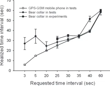
In the tests without the bear (in which the collar and the mobile phone were placed together in one spot), the GPS–GSM mobile phone kept the programmed time interval better than the collar for short time intervals. The difference disappeared when the time interval was increased to 25–30 seconds (Fig. 3). With intervals of less than 20 seconds, the realized time intervals clearly were longer than the set ones in the bear collar. Furthermore, in the case of the shortest intervals, variation in the realized time intervals was quite high for the collar. We obtained the shortest realized time interval, 24.66 4.3 sec (mean 6 SE), when the requested time interval was 20 seconds.
In the approaching experiments, we studied only the collar’s ability to keep the required time interval. The realized intervals tended to be longer than in the tests without the bear. We obtained the best results with a requested interval of 25 seconds, when the realized interval was 31.8 seconds (61.2 SE).
Time Lag
The time between obtaining the location information and its arrival to the short message center was independent of the requested time interval but different for the GPS–GSM mobile phone and the collar (ANOVA for time interval;F7, 391¼0.73,P ¼ 0.65, for method; F1, 391 ¼ 508.00, P 0.001, and for
interaction; F1, 391¼0.50, P¼0.84). The GPS–GSM mobile
phone sent the location message to the short message center within 3.8 seconds on average (60.09 SE, range 2–19 s,n¼210), while it took 13.4 seconds (60.3 SE, range 10–29 s,n¼197) for the collar to do it.
The Approaching Experiments
The behavior of the bear varied greatly among the experiments, but 3 common modes of behavior and their combinations were evident: hiding (i.e., not moving), escaping, and approaching people or their tracks. We observed hiding in 11 of the 12 experiments, and it was usually associated with escape (hiding before or after the escape). We observed this behavior in 9 experiments. In 3 experiments, the bear approached people or their tracks. These 3 cases also involved the bear hiding and escaping. In the cases where the bear only hid, it was passed at the distances of 44, 72, 76, and 110 m.
The escape distances varied from 37 to 624 m (mean 212 m673 SE). The escape speed, if any, varied from less than 1–31 km/hr. The escape usually started with slow motion, and the speed increased with distance from the people. All the results are based solely on observations obtained with the GPS–GSM collar. We did not see or hear the bear during any of the experiments.
Discussion and Management Implications
Our results demonstrate that the GPS–GSM technology is reliable and accurate enough for studying animal behavior. There are ongoing studies that use GPS–GSM technology, but as far as we know, none of them are focused on obtaining real-time observations of study animals. In our case, we are still about 16–20 Figure 1.Dispersion of the spatial locations of a stationary GPS–GSM mobilephone (upper panel) and GPS–GSM bear collar (lower panel) measured as the distance between all pairs of locations. The dispersion of spatial locations was determined by requesting location information at different time intervals and different locations (loc). Box boundaries show 25th and 75th, whiskers 10th and 90th, and dots 5th and 95th percentiles. The thick horizontal line is the median and the thin line is the mean. Numbers below the boxes indicate the number of distance measurements.
seconds away from the goal of real-time observations because of the time needed to deliver the location message to the receiver. Another shortcoming of the current technology is that the location messages from the collar are recorded at the rate of 2–3 per min. However, because the GPS–GSM mobile phone was capable of faster and more frequent message delivery (up to 20/ min) than the bear collar, it should be possible to improve the performance of future collars. On the other hand, trade offs among the interval between location messages, accuracy of locations (worse in GPS–GSM mobile phone) and energy consumption (higher in GPS–GSM mobile phone), may make it undesirable to maximize the delivery rate of the collar.
In general, the transmission of GPS data via a mobile phone network (GSM or any other mobile phone system) is practical because data can be received in any location connected to the network. If an Internet server is used for receiving data, access to the Internet is all that is required. Commercial Internet servers can provide various services, but this may increase research costs. Using the GPS–GSM mobile phone as a receiver, the spatial locations can be observed on the map of the receiver, but data storage is limited compared to PC- or Internet-based methods. An advantage of the GPS–GSM mobile phone is that animals are easy to track directly in the field. An ordinary mobile phone can store only a limited number of short messages, and the information has to be transferred to a computer to be displayed on a map. Independent of receiving methods the use of mobile phone network for data transmission may lead to significant savings in large predator studies because the animals often move over long distances (e.g., Ballard et al. 1982). Additionally, multiple animals can be tracked simultaneously from one place without the need for many researchers to follow the animals on foot or in motorized vehicles, as is necessary for traditional radiotracking.
The drawbacks of GPS–GSM-based systems are their high cost, large size, and weight. The use of GPS–GSM collars is, therefore,
limited to large animals capable of carrying a heavy collar, and the research may be restricted to tracking a small number of animals (often the case in research with large predators). Another consideration is the paucity of large regions with extensive natural landscapes and vegetation communities that concomitantly have good coverage by a mobile phone network. Our study area was favorable in this respect because the GSM mobile phone network covers almost the entire country of Finland (338,145 km2). Good GSM coverage is indicated by the high success rate of the GSM module in our study.
One potential problem common to all GPS-based methods is the failure to obtain GPS locations (Schwartz and Arthur 1999). Our results suggest that failures of the collar were not so much related to the habitat (even if this was not studied systematically) but to the position of the GPS antenna. During the course of our experi-ments, we often were unable to obtain new location information when the bear was in its daytime resting place, but when people approached the bear, new locations were received. We believe that, while resting, the bear turned the collar into a position in which the bulky battery case was not below its throat. In this position, the antennas were parallel to the ground, and, therefore, the connection to the satellites was poor. We hypothesize that when the bear became aware of approaching people, it stood up, the heavy battery case dropped below its neck, and the antennas pointed upward allowing connection to the satellites.
Despite these shortcomings, the method worked well for our purpose, and we were able to obtain new and interesting data on bear behavior that would have been impossible to obtain using other methods. Because we conducted the approaching experi-ments with only 1 bear and the number of trials was limited, we have referred to the results only to describe the method and to illustrate the opportunities now available, while we do not discuss the preliminary results further.
The results on the location accuracy of the equipment show that a 65-m error should be added to our distance estimates. The Figure 2.The success rate of obtaining requested information in relation to the
set time interval in the collar in tests with and without the bear. The total success rate is the product of GPS module’s capability of successfully locating itself and GSM module’s success in sending the location message. The success rate of the GSM in tests (open symbols) was always 100%, hence the total success rate also represents the success rate of the GPS.
Figure 3.Realized versus requested time interval with the GPS–GSM mobile phone and the bear collar. In tests without the bear, a person carried both the GPS–GSM mobile phone and the bear collar in different habitats or both pieces of equipment were lying on the ground within 1 m of each other.
distance estimates also are affected by the times of obtaining the locations for the GPS–GSM mobile phone and the bear collar, which were not always synchronous. This problem can be avoided by assuming direct movement and constant speed for both the people and the bear and interpolating their locations at any particular point of time. In this study, locations were not interpolated in such a manner because in most cases the times of locating the people and the bear were within 10 seconds.
In conclusion, the GPS–GSM-based tracking method has great potential. It is possible to develop the method further to increase accuracy of locations and to decrease the time intervals between successive locations. The new 3G mobile phone networks will allow better and faster data transmission, which opens up new
opportunities for animal tracking. We believe that with reduced cost of the equipment in the future, the GPS mobile phone-based tracking will be the most cost-effective method for studying large animals in areas with a sufficiently dense mobile phone network.
Acknowledgments
We thank E. Eskelinen, E. Grenfors, M. Haapakoski, E. Kallio, S. Ma¨kela¨inen, L. Veneranta, and K. Va¨lima¨ki for approaching the bear, and A. Hakala, S. Ronkainen, M. Suominen, and K. Turunen for collaring the bear. This study was funded by the Jenny and Antti Wihuri and Ella and Georg Ehrnrooth Foundations as well as by the Academy of Finland (project 44887; Finnish Centre of Excellence Programme 2000–2005).
Literature Cited
Ballard, W. B., S. D. Miller, and T. H. Spaker. 1982. Home range, daily movements and reproductive biology of brown bearUrsus arctosin south central Alaska. Canadian Field-Naturalist 96:1–5.
Fagen, J. M., and R. Fagen. 1994. Interactions between wildlife viewers and habituated brown bears. Natural Areas Journal 14:159–164.
Fagen, R., and J. M. Fagen. 1996. Individual distinctiveness in brown bears, Ursus arctos L. Ethology 102:212–226.
Finland Ministry of Agriculture and Forestry. 2003. Hunting quotas for the year 2004 confirmed. News Letter of Ministry of Agriculture and Forestry 16.6.2003. [In Finnish.]
Olson, T., B. K. Gilbert, and R. C. Squibb. 1997. Effects of increasing human activity on brown bear use of an Alaskan river. Biological Conservation 82: 95–99.
Palmen, J. A. 1913. Ba¨r, wolf und luchs in Finland. Zoologischer Beobachter 54:1–6.
Pulliainen, E. 1983. Behaviour of expanding population of the brown bear Ursus arctosin northern Europe. Zeitschrift fu¨r die Sa¨ugertierkunde 48:290– 297.
Schwartz, C. C., and S. M. Arthur. 1999. Radiotracking large wilderness mammals: intergration of GPS and Argos technology. Ursus 11:261–273.
Janne Sundell (photo) works as a postdoctoral researcher in Metapopulation Research Group at the University of Helsinki, Finland. He completed his Ph.D. thesis on predation effects on vole population dynamics at the University of Helsinki in 2002. The main themes of his studies include population level consequences of predator–prey interaction as well as hunting behavior of the predator and antipredator behavior of the prey. Ilpo Kojola is a senior research scientist at the Finnish Game and Fisheries Research Institute in Oulu. He received his B.Sc. and Ph.D. from the University of Jyva¨skyla¨, Finland. Ilpo’s main interests are ecology of large carnivores and ungulates in boreal forests. Ilkka Hanskiis a research professor at the University of Helsinki and the director of the Metapopulation Research Group in the same institute. He received his D.Phil. from the University of Oxford in 1979. Hanski has worked on a wide range of topics in population and community ecology and conservation biology. His best-known contributions include empirical and theoretical studies in
metapopulation biology and the modelling of the small rodent–mustelid interaction.