D2.8.III.4 Data Specification on Land Use – Draft Guidelines
Title D2.8.III.4 INSPIRE Data Specification on Land Use – Draft Guidelines Creator INSPIRE Thematic Working Group Land Use
Date 2011-06-15
Subject INSPIRE Data Specification for the spatial data theme Land Use Publisher INSPIRE Thematic Working Group Land Use
Type Text
Description This document describes the INSPIRE Data Specification for the spatial data theme Land Use
Contributor Members of the INSPIRE Thematic Working Group Land Use Format Portable Document Format (pdf)
Source
Rights Public
Identifier D2.8.III.4_v2.0 Language En
Relation Directive 2007/2/EC of the European Parliament and of the Council of 14 March 2007 establishing an Infrastructure for Spatial Information in the European Community (INSPIRE)
Foreword
How to read the document?
This document describes the “INSPIRE data specification on Land Use – Guidelines” version 2.0 as developed by the Thematic Working Group (TWG) Land Use using both natural and a conceptual schema language. This version is now available for the public consultation. Based on the results of the consultation (received comments and the testing reports), the final version 3.0 will be prepared by the TWGs.
The data specification is based on a common template used for all data specifications and has been harmonised using the experience from the development of the Annex I data specifications.
This document provides guidelines for the implementation of the provisions laid down in the draft Implementing Rule for spatial data sets and services of the INSPIRE Directive.
This document includes two executive summaries that provide a quick overview of the INSPIRE data specification process in general, and the content of the data specification on Land Use in particular. We highly recommend that managers, decision makers, and all those new to the INSPIRE process and/or information modelling should read these executive summaries first.
The UML diagrams (in Chapter 5) offer a rapid way to see the main elements of the specifications and their relationships. The definition of the spatial object types, attributes, and relationships are included in the Feature Catalogue (also in Chapter 5). People having thematic expertise but not familiar with UML can fully understand the content of the data model focusing on the Feature Catalogue. Users might also find the Feature Catalogue especially useful to check if it contains the data necessary for the applications that they run. The technical details are expected to be of prime interest to those organisations that are/will be responsible for implementing INSPIRE within the field of Land Use. The technical provisions and the underlying concepts are often illustrated by examples. Smaller examples are within the text of the specification, while longer explanatory examples and descriptions of selected use cases are attached in the annexes.
In order to distinguish the INSPIRE spatial data themes from the spatial object types, the INSPIRE spatial data themes are written in italics.
The document will be publicly available as a ‗non-paper‘. It does not represent an official position of the European Commission, and as such cannot be invoked in the context of legal procedures.
Legal Notice
Neither the European Commission nor any person acting on behalf of the Commission is responsible for the use which might be made of this publication.
Interoperability of Spatial Data Sets and Services –
General Executive Summary
The challenges regarding the lack of availability, quality, organisation, accessibility, and sharing of spatial information are common to a large number of policies and activities and are experienced across the various levels of public authority in Europe. In order to solve these problems it is necessary to take measures of coordination between the users and providers of spatial information. The Directive 2007/2/EC of the European Parliament and of the Council adopted on 14 March 2007 aims at establishing an Infrastructure for Spatial Information in the European Community (INSPIRE) for environmental policies, or policies and activities that have an impact on the environment.
INSPIRE will be based on the infrastructures for spatial information that are created and maintained by the Member States. To support the establishment of a European infrastructure, Implementing Rules addressing the following components of the infrastructure are being specified: metadata, interoperability of spatial data themes (as described in Annexes I, II, III of the Directive) and spatial data services, network services and technologies, data and service sharing, and monitoring and reporting procedures.
INSPIRE does not require collection of new data. However, after the period specified in the Directive1 Member States have to make their data available according to the Implementing Rules.
Interoperability in INSPIRE means the possibility to combine spatial data and services from different sources across the European Community in a consistent way without involving specific efforts of humans or machines. It is important to note that ―interoperability‖ is understood as providing access to spatial data sets through network services, typically via Internet. Interoperability may be achieved by either changing (harmonising) and storing existing data sets or transforming them via services for publication in the INSPIRE infrastructure. It is expected that users will spend less time and efforts on understanding and integrating data when they build their applications based on data delivered within INSPIRE.
In order to benefit from the endeavours of international standardisation bodies and organisations established under international law their standards and technical means have been utilised and referenced, whenever possible.
To facilitate the implementation of INSPIRE, it is important that all stakeholders have the opportunity to participate in specification and development. For this reason, the Commission has put in place a consensus building process involving data users, and providers together with representatives of industry, research and government. These stakeholders, organised through Spatial Data Interest Communities (SDIC) and Legally Mandated Organisations (LMO)2, have provided reference materials, participated in the user requirement and technical3 surveys, proposed experts for the Data Specification Drafting Team4 and Thematic Working Groups5.
1
For all 34 Annex I,II and III data themes: within two years of the adoption of the corresponding Implementing Rules for newly collected and extensively restructured data and within 5 years for other data in electronic format still in use
2
Number of SDICs and LMOs on 8/6/2011 was 461 and 249 respectively
3
Surveys on unique identifiers and usage of the elements of the spatial and temporal schema,
4
The Data Specification Drafting Team has been composed of experts from Austria, Belgium, Czech Republic, France, Germany, Greece, Italy, Netherlands, Norway, Poland, Switzerland, UK, and the European Environmental Agency
5
The Thematic Working Groups of Annex II and III themes have been composed of experts from Austria, Belgium, Bulgaria, Czech Republic, Denmark, Finland, France, Germany, Hungary, Ireland, Italy, Latvia, Netherlands, Norway, Poland, Romania, Slovakia, Spain, Sweden, Switzerland, Turkey, UK, the European Commission, and the European Environmental Agency
This open and participatory approach was successfully used during the development of the data specification on Annex I data themes as well as during the preparation of the Implementing Rule on Interoperability of Spatial Data Sets and Services6 for Annex I spatial data themes.,
The development framework elaborated by the Data Specification Drafting Team aims at keeping the data specifications of the different themes coherent. It summarises the methodology to be used for the data specifications and provides a coherent set of requirements and recommendations to achieve interoperability. The pillars of the framework are four technical documents:
The Definition of Annex Themes and Scope7 describes in greater detail the spatial data themes defined in the Directive, and thus provides a sound starting point for the thematic aspects of the data specification development.
The Generic Conceptual Model8 defines the elements necessary for interoperability and data harmonisation including cross-theme issues. It specifies requirements and recommendations with regard to data specification elements of common use, like the spatial and temporal schema, unique identifier management, object referencing, a generic network model, some common code lists, etc. Those requirements of the Generic Conceptual Model that are directly implementable will be included in the Implementing Rule on Interoperability of Spatial Data Sets and Services.
The Methodology for the Development of Data Specifications9 defines a repeatable methodology. It describes how to arrive from user requirements to a data specification through a number of steps including use-case development, initial specification development and analysis of analogies and gaps for further specification refinement. The ―Guidelines for the Encoding of Spatial Data‖10
defines how geographic information can be encoded to enable transfer processes between the systems of the data providers in the Member States. Even though it does not specify a mandatory encoding rule it sets GML (ISO 19136) as the default encoding for INSPIRE.
Based on these framework documents and following the successful development of the Annex I Data specifications (Technical Guidelines) and the Implementing Rules, the new Thematic Working Groups have created the INSPIRE data specification for each Annex II and III theme. These documents – at the version 2.0 – are now publicly available for INSPIRE stakeholders for consultation. The consultation phase covers expert review as well as feasibility and fitness-for-purpose testing of the data specifications.
The structure of the data specifications is based on the ―ISO 19131 Geographic information - Data product specifications‖ standard. They include the technical documentation of the application schema, the spatial object types with their properties, and other specifics of the spatial data themes using natural language as well as a formal conceptual schema language11.
A consolidated model repository, feature concept dictionary, and glossary are being maintained to support the consistent specification development and potential further reuse of specification elements. The consolidated model consists of the harmonised models of the relevant standards from the ISO 19100 series, the INSPIRE Generic Conceptual Model, and the application schemas12 developed for
6
Commission Regulation (EU) No 1089/2010 implementing Directive 2007/2/EC of the European Parliament and of the Council as regards interoperability of spatial data sets and services, published in the Official Journal of the European Union on 8th of December 2010.
7 http://inspire.jrc.ec.europa.eu/reports/ImplementingRules/DataSpecifications/D2.3_Definition_of_Ann ex_Themes_and_scope_v3.0.pdf 8 http://inspire.jrc.ec.europa.eu/reports/ImplementingRules/DataSpecifications/D2.5_v3.3.pdf 9 http://inspire.jrc.ec.europa.eu/reports/ImplementingRules/DataSpecifications/D2.6_v3.0.pdf 10 http://inspire.jrc.ec.europa.eu/reports/ImplementingRules/DataSpecifications/D2.7_v3.2.pdf 11 UML – Unified Modelling Language
12
each spatial data theme. The multilingual INSPIRE Feature Concept Dictionary contains the definition and description of the INSPIRE themes together with the definition of the spatial object types present in the specification. The INSPIRE Glossary defines all the terms (beyond the spatial object types) necessary for understanding the INSPIRE documentation including the terminology of other components (metadata, network services, data sharing, and monitoring).
By listing a number of requirements and making the necessary recommendations, the data specifications enable full system interoperability across the Member States, within the scope of the application areas targeted by the Directive. They will be published (version 3.0) as technical guidelines and will provide the basis for the content of the Amendment of the Implementing Rule on Interoperability of Spatial Data Sets and Services for data themes included in Annex II and III of the Directive. The Implementing Rule Amendment will be extracted from the data specifications keeping in mind short and medium term feasibility as well as cost-benefit considerations. The Implementing Rule will be legally binding for the Member States.
In addition to providing a basis for the interoperability of spatial data in INSPIRE, the data specification development framework and the thematic data specifications can be reused in other environments at local, regional, national and global level contributing to improvements in the coherence and interoperability of data in spatial data infrastructures.
Land Use – Executive Summary
Land Use is included in Annex III, which means that it is a specific thematic field. The INSPIRE data specification on Land Use has been prepared in view of following the participative principle of consensus building process. The stakeholders, based on their registration as a Spatial Data Interest Community (SDIC) or a Legally Mandated Organisation (LMO) had the opportunity to bring forward user requirements and reference materials, propose experts for the specification development and will participate in the review of the data specifications.
The Thematic Working Group responsible for the Land Use specification development was composed of experts coming from Belgium, Finland, France, Germany, the Netherlands, Poland, Spain, and the European Commission. The specification process took place according to the methodology elaborated for INSPIRE respecting the requirements and the recommendation of the INSPIRE Generic Conceptual Model, which is one of the elements that ensures a coherent approach and cross-theme consistency with other themes in the Directive. Furthermore, use cases from other themes requiring Land Use data has been investigated. The analysis concluded that the proposed model for Land use meets the requirements. The ongoing consultation and testing will ascertain this statement.
The cornerstone of the specification development was the fact that Land use shapes our environment in positive and negative ways. Productive land is a critical resource for food and biomass production and land use strongly influences soil erosion and soil functions such as carbon storage. Land management largely determines the beauty of Europe's landscapes. It is important therefore to monitor land cover and land-use change13.
In the INSPIRE directive, Land Use is defined as Territory characterised according to its current and future planned functional dimension or socio-economic purpose (e.g. residential, industrial, commercial, agricultural, forestry, recreational). [Directive 2007/2/EC] It is the description of land in terms or its socio-economic and ecological purpose.
Land Use is itself split up into two different types:
1. The Existing Land Use or ELU (Current Land Use in the above definition), which objectively depicts the use and functions of a territory as it has been and effectively still is in real life. Geographical data-sets that provide Land Use information, at the time of observation, are organised as a partition (in the mathematical sense) of a given area. Each element of the partition is homogeneous regarding the dominant functional use of land. Geographical data-sets that provide Land Use information, at the time of observation, can also be a discrete set of discrete observation points informing on the use at the exact location and or at its surrounding.
2. The Planned Land Use or PLU (Future Planned Land Use in the above definition), which is composed of spatial plans, defined by spatial planning authorities, depicting the possible utilization of the land in the future. Planned land use is regulated by spatial planning documents elaborated at various levels of administration. Land use regulation over a geographical area is composed of an overall strategic orientation, a textual regulation and a cartographic representation. Spatial planning documents result from the spatial planning process, once adopted and therefore which third parties must conform with. The scope of the INSPIRE Land Use Data Specification is giving the exact spatial dimension of all the elements a spatial plan is composed of.
The Land Use data model consists of a core model which can be applied for ELU and PLU. The core element of the Land Use data model (CoreLandUseObject) is a piece of land that has a homogeneous dominant land use.
For Planned Land Use CoreLandUseObject is called ZoningElement in order to be consistent with the terminology used by spatial planners. SupplementaryRegulation enables to inform on regulations that superimposes on the zoning.
13
SOER Synthesis, 2010. The European environment — state and outlook 2010: synthesis. European Environment Agency, Copenhagen.
The Land Use data model supports two systems of classification:
the (obligatory) Hierarchical INSPIRE Land Use Classification System (HILUCS) which is a multi-level, classification system that will apply to both the ELU and the PLU
the (optional) local classification system of a member state.
Land use has connexion with several other INSPIRE themes but it has been preferred not to include relationships with these themes in the model assuming that geometric functions of user information systems will enable to compute the spatial relationships such as inclusion or overlap.
As stated by the INSPIRE directive, Land Use is different from Land Cover (LC, Annex II, theme number 2). The choice has been made to consider those two themes with different geometries.
Planned Land use information is often overlaid on cadastral parcels. The choice has been made to allow the data provider to inform on the version of the cadastral map which the spatial plan has been drawn over without implementing direct relationships with the Cadastral parcels as described in the INSPIRE Data Specification on Cadastral Parcels (CP, Annex I theme 6)
Planned land use incorporate elements that in the real world can be related to other INSPIRE spatial data themes such as Area management/restriction/regulation zones and reporting units (AM, Annex III theme 11) or Natural Risk Zones (NZ, annex III theme 12). These will be seen as supplementary regulation in the Land Use data model (planned land Use) as soon as this information is incorporated in the legal spatial plan.
Spatial Plan Legal Restricted zones Regulated zones Legal ENV Non-ENV
Risk prevention Plan Legal
Natural Risk Zones Area Management
Reporting units
AM scope
NZ scope
LU scope
Comparable data on top of harmonised specification elements create additional value for achieving interoperability in INSPIRE. For this finality the data specification on Land Use includes recommendations on reporting data quality parameters.
Regardless whether these recommendations on data quality are met, the actual values of data quality elements should be published as metadata. These elements usually have to be published at the dataset level.
For visualisation purposes, simple rules for default portrayal are given by specifying the colour attached to each class of Hierarchical INSPIRE Land Use Classification System at level 1.
The main value of the INSPIRE Land Use model is its simplicity, a yet flexible structure that allows data providers to publish their existing data in the most convenient way. It is expected that the on-going consultation and testing will help explaining how to implement this data specification including in how to use it for structure plans and construction plans.
Acknowledgements
Many individuals and organisations have contributed to the development of these Guidelines. The Thematic Working Group Land Use (TWG-LU) included:
François Salgé (TWG Facilitator), Wilko Quak (TWG Editor), Aaro Mikkola, Anneloes van Noordt, Gerard Willem Hazeu, Isabel Goñi, Julián Delgado Hernández, Kai-Uwe Krause, Maria Andrzejewska, Marjo Kasanko, Walter Richter, Maria Vanda Nunes de Lima (European Commission contact point). The Drafting Team Data Specifications included:
Clemens Portele (Chair), Andreas Illert (Vice-chair), Kristine Asch, Marek Baranowski, Eric Bayers, Andre Bernath, Francis Bertrand, Markus Erhard, Stephan Gruber, Heinz Habrich, Stepan Kafka, Dominique Laurent, Arvid Lillethun, Ute Maurer-Rurack, Keith Murray, George Panopoulos, Claudia Pegoraro, Marcel Reuvers, Anne Ruas, Markus Seifert, Peter Van Oosterom, Andrew Woolf and the European Commission contact points: Steve Peedell, Katalin Tóth, Paul Smits, Vanda Nunes de Lima. The data specifications team of the Spatial Data Infrastructures Unit of the Joint Research Centre included the members who have been participating at different steps of the process:
Klaudia Bielinska, Freddy Fierens, Anders Friis-Christensen, Julien Gaffuri, Darja Lihteneger, Michael Lutz, Vanda Nunes de Lima, Angel Lopez, Nicole Ostländer, Steve Peedell, Alessandro Sarretta, Jan Schulze Althoff, Paul Smits, Robert Tomas, Katalin Tóth, Martin Tuchyna.
The Consolidated UML repository has been set up by Michael Lutz, Anders Friis-Christensen, and Clemens Portele. The INSPIRE Registry has been developed by Angelo Quaglia and Michael Lutz. The INSPIRE Feature Concept Dictionary and Glossary has been consolidated by Darja Lihteneger. The data specification testing has been coordinated by Martin Tuchyna. The Testing communication tools have been set up by Loizos Bailas, Karen Fullerton and Nicole Ostländer. Web communication and tools for the consultations have been developed by Karen Fullerton and Hildegard Gerlach. The stakeholders participated, as Spatial Data Interested Communities (SDIC) or Legally Mandated Organisations (LMO), in different steps of the development of the data specification development framework documents and the technical guidelines, providing information on questionnaires and user surveys, participating in the consultation process and workshops, testing the draft data specifications and supporting the work of their members in the Thematic Working Groups and Drafting Team Data Specifications.
Contact information Vanda Nunes de Lima
European Commission Joint Research Centre Institute for Environment and Sustainability Spatial Data Infrastructures Unit
TP262, Via Fermi 2749 I-21027 Ispra (VA) ITALY E-mail: [email protected] Tel.: +39-0332-7865052 Fax: +39-0332-7866325 http://ies.jrc.ec.europa.eu/ http://ec.europa.eu/dgs/jrc/ http://inspire.jrc.ec.europa.eu/
Table of contents
1 Scope ... 1
2 Overview ... 1
2.1 Name ... 1
2.2 Informal description ... 1
2.2.1 Existing land use ... 2
2.2.2 Planned land use ... 3
2.3 Normative References ... 5
2.4 Terms and definitions ... 6
2.5 Symbols and abbreviations ... 7
2.6 Notation of requirements and recommendations ... 7
2.7 Conformance ... 8
3 Specification scopes ... 8
4 Identification information ... 8
5 Data content and structure ... 8
5.1 Basic notions ... 9
5.1.1 Stereotypes ... 9
5.1.2 Placeholder and candidate types... 9
5.1.3 Voidable characteristics ... 10
5.1.4 Code lists and Enumerations ... 11
5.2 Application schema Land Use ... 11
5.2.1 Description ... 11
5.2.2 Feature catalogue - Land Use Core Model ... 25
5.2.3 Feature catalogue - Existing Land Use ... 32
5.2.4 Feature catalogue - Planned Land Use ... 35
6 Reference systems ... 45
6.1 Coordinate reference systems ... 45
6.1.1 Datum ... 45
6.1.2 Coordinate reference systems ... 46
6.1.3 Display ... 46
6.1.4 Identifiers for coordinate reference systems ... 47
6.2 Temporal reference system ... 47
6.3 Theme-specific requirements and recommendations on reference systems ... 47
7 Data quality ... 47
7.1 Data quality elements and measures... 48
7.1.1 Completeness – Commission ... 48
7.1.2 Completeness – Omission ... 49
7.1.3 Logical Consistency – Topological consistency ... 49
7.1.4 Positional accuracy – Absolute or external accuracy ... 50
7.1.5 Logical consistency – Domain consistency ... 51
7.1.6 Thematic accuracy – Classification correctness ... 52
7.1.7 Thematic accuracy – Non-quantitative attribute correctness ... 52
7.2 Minimum data quality requirements and recommendations ... 52
8 Dataset-level metadata ... 53
8.1 Common metadata elements ... 53
8.1.1 Coordinate Reference System ... 55
8.1.2 Temporal Reference System ... 55
8.1.3 Encoding ... 56
8.1.5 Data Quality – Logical Consistency – Topological Consistency ... 57
8.2 Metadata elements for reporting data quality ... 58
8.3 Theme-specific metadata elements ... 59
8.3.1 Maintenance Information ... 60
8.3.2 Data Quality – Completeness – Commission ... 60
8.3.3 Data Quality – Completeness – Omission ... 61
8.3.4 Data Quality – Logical Consistency – Topological consistency ... 61
8.3.5 Data Quality – Logical Consistency – Domain consistency ... 61
8.3.6 Data Quality - Positional accuracy – Absolute or external accuracy ... 62
8.3.7 Data Quality - Thematic Accuracy - Classification correctness ... 62
8.3.8 Data Quality - Thematic Accuracy - Non-quantitative attribute correctness ... 62
8.4 Guidelines on using metadata elements defined in Regulation 1205/2008/EC ... 63
8.4.1 Conformity ... 63 8.4.2 Lineage ... 63 8.4.3 Temporal reference ... 64 9 Delivery ... 64 9.1 Delivery medium ... 64 9.2 Encodings ... 65 9.2.1 Default Encoding(s) ... 65 10 Data Capture ... 65 11 Portrayal ... 66
11.1 Layers to be provided by INSPIRE view services ... 66
11.1.1 Layers organisation ... 67
11.2 Styles to be supported by INSPIRE view services ... 67
11.2.1 Styles for the layer LandUse.ExistingLandUseCoverage ... 67
11.2.2 Styles for the layer LandUse.SpatialPlan ... 68
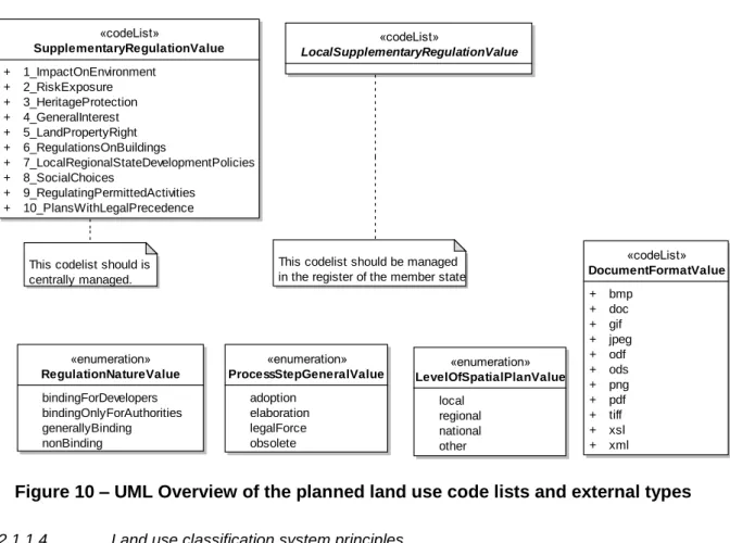
11.2.3 Styles for the layer LandUse.SupplementaryRegulation ... 68
Bibliography ... 70
Annex A (normative) Abstract Test Suite ... 71
Annex B (informative) Use cases ... 72
B.1 Introduction ... 72
B.2 Land Planning ... 72
B.2.1 Narrative description ... 72
B.2.2 Involved actors ... 74
B.2.3 Detailed description ... 74
B.3 Analysis of land consumption ... 76
B.3.1 Narrative description ... 76
B.3.2 Involved actors ... 76
B.3.3 Detailed description ... 77
B.4 Ecological network map ... 78
B.4.1 Narrative description ... 78
B.4.2 Involved actors ... 79
B.4.3 Detailed description ... 79
B.5 Land use and land-use change and forestry for greenhouse inventory reporting ... 80
B.5.1 Narrative description ... 80
B.5.2 Involved actors ... 83
B.5.3 Detailed description ... 83
B.6 Other use cases ... 84
B.6.1 Land use for environmental impact assessment ... 84
B.6.2 Land use for the flood directive... 84
B.6.3 Statistics for land use ... 85
B.6.4 Land use for soil management ... 86
B.7.1 Features ... 87 B.7.2 Nomenclature... 87 B.7.3 Temporal dimension ... 87 B.7.4 Identifiers ... 87 B.7.5 Portrayal ... 87 B.7.6 Metadata ... 88
B.7.7 Consistency with other themes ... 88
B.8 Planned land use data requirements ... 88
B.8.1 Features ... 88 B.8.2 Nomenclature... 89 B.8.3 Temporal dimension ... 89 B.8.4 Identifiers ... 89 B.8.5 Portrayal ... 89 B.8.6 Metadata ... 89
B.8.7 Consistency with other themes ... 89
B.9 Key aspects ... 89
Annex C (informative) Towards the Hierarchical INSPIRE Land Use nomenclature ... 90
C.1 Investigated classification systems ... 90
C.1.1 LUCAS (Land Use / Cover Area Frame Survey) ... 91
C.1.2 Urban Atlas ... 91
C.1.3 Plan4All ... 92
C.1.4 FR-CNIG – Plan local d‘urbanisme – Plan d‘occupation des sols ... 93
C.1.5 NL-BBG – Bestand Bodemgebruik ... 93
C.1.6 UK-National Land Use Database: Land Use and Land Cover Classification ... 93
C.1.7 US-LBCS (Land-Based Classification Standards)... 94
C.2 Conclusions ... 94
C.3 Proposed version of HILUCS ... 95
C.4 Mapping HILUCS with LUCAS, NACE and Urban Atlas... 99
Annex D (informative) Land use and Land Cover Relations ... 103
D.1 Land cover and land use definitions ... 103
D.2 Dependencies and consequences between land cover and land use ... 104
D.3 Land unit ... 104
Annex E (informative) Proposed changes to D2.3 V3.0 ... 107
E.1 Land use plans/ land use regulation ... 107
E.2 Functional land use – according to socio-economic purpose ... 108
E.3 Scope, use examples ... 108
E.4 Important feature types and attributes ... 109
E.5 Links and overlaps with other themes... 109
E.6 Reference documents ... 110
1 Scope
This document specifies a harmonised data specification for the spatial data theme Land Use as defined in Annex III of the INSPIRE Directive.
This data specification provides the basis for the drafting of Implementing Rules according to Article 7 (1) of the INSPIRE Directive [Directive 2007/2/EC]. The entire data specification will be published as implementation guidelines accompanying these Implementing Rules.
2 Overview
2.1 Name
INSPIRE data specification for the theme Land Use
2.2 Informal description
Definition:
Territory characterised according to its current and future planned functional dimension or socio– economic purpose (e.g. residential, industrial, commercial, agricultural, forestry, recreational). [Directive 2007/2/EC]
Description:
The definition of the INSPIRE spatial data theme ‗Land Use‘ stresses two important parts of this theme:
First of all Land Use is defined as the use and functions of a territory. It is the description of land in terms or its socio-economic and ecological purpose. Land use is different from Land Cover (Annex III, theme number 3), dedicated to the description of the surface of the earth by its (bio-)physical characteristics. Land Cover and Land Use are, however, related and often combined in practical applications. Data sets combining Land Use and Land Cover often emphasize land use aspects in intensively used areas and land cover aspects in extensively used areas. An example of the difference in description of the same piece of land would be an agricultural area with grass. In Land Cover it would be described as a pasture (the cover of the land is grass), while in Land Use it would be classified as agriculture (its use would be for grazing cattle).
Secondly Land Use is itself split up into two different types:
The Existing Land Use or ELU (Current Land Use in the above definition), which objectively depicts the use and functions of a territory as it has been and effectively still is in real life. The Planned Land Use or PLU (Future Planned Land Use in the above definition), which is
composed of spatial plans, defined by spatial planning authorities, depicting the possible utilization of the land in the future.
To accommodate the wide variety of spatial information that is already available on Land Use (both existing and planned Land Use), a data model is described in chapter 5 that is as open ended as possible. It consists of a core model which can be applied for ELU and PLU and supports two different systems of classification. First of all there is the (obligatory) Hierarchical INSPIRE Land Use Classification System or HILUCS. This is a new, multi-level, classification system that will apply to both
the ELU and the PLU. It will be general enough for the member states to map their specific classification system to the first (mandatory) level of HILUCS. This classification system will allow comparing the different data sets from different member states. The second (voidable) possibility is to add the local classification system of the member state. This system should however be well documented, allowing users to use the data and compare it with datasets from other sources. The core model can be extended with the specialised models for Existing Land Use and Planned Land Use.
The scope of the theme Land Use includes not only the earth's surface, but also what is below and above restricted to its physical impact at ground level. The inland water bodies as well as coastal waters are considered in the Land use theme as soon as they participate to the use of connected piece of land, e.g. a harbor includes the water that is inside the harbor.
2.2.1
Existing land use
Geographical data-sets that provide Land Use information, at the time of observation, are often organised as a partition (in the mathematical sense) of a given area (see Figure 1). Each element of the partition (polygon) is homogeneous regarding the dominant functional use of land. The fact that one dominant land use is defined does not mean only one land use exists, the model will provide the possibility to also map the other land uses in the same area. The polygons do not overlap each other and their union covers the given area (i.e. "polygons" are both collectively exhaustive and mutually exclusive). The area covered by a Land Use data set may differ from the area managed by an authority due to multiple reason including the data capture method (e.g. from imagery) or the legal context.
Geographical data-sets that provide Land Use information, at the time of observation, may also be organised as discrete set of points each of them being observed and associated with attributes describing the land use.
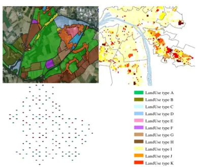
Figure 1 – example of existing Land Use datasets
left: Urban Atlas over Bruxelles, Belgium
right: Land Use over the city of Espoo, Finland
A nomenclature provides the functional uses that are taken into consideration; many nomenclatures exist in the world today, from those applicable at continental level, to those defined locally. For the INSPIRE Land Use theme the new HILUCS classification system (e.g. agriculture, forestry, industrial areas, networks and basic infrastructures, residential areas etc.) will be used. In most cases human activities on a homogeneous polygon includes the ―infrastructures‖ necessary for the activity to take place (e.g. for an industrial area the polygon includes car-parks necessary for the staff and clients, gardens necessary for the ―well fare‖, warehouses for the stocks, front office – back office).
Each separate dataset of Existing Land Use will be a snapshot of a certain moment in time, the added value of these separate datasets with different timestamps is the fact that Land Use changes over time can be monitored if they are put together.
Associated with the nomenclature, the minimum unit of interest (MUI, also called minimum mapping unit or observation unit) defines the level of detail for the partition, i.e. the minimum size of the polygons that are in the dataset.
2.2.2
Planned land use
In the context of INSPIRE, sharing land use information supports the requirements common in spatial planning. The spatial plans established at the various levels of administration need to be supported by other spatial plans made by public authorities at different levels or even with spatial plans across the border of a nation. Different zoning elements across borders can have a great influence on each other. Planned land use is regulated by spatial planning documents elaborated at various levels of administration.
Land use regulation over a geographical area (spatial planning documents resulting from the spatial planning process, once adopted and therefore which third parties must conform with) is often composed of three parts:
the overall strategic orientation that describes the development will of the competent administrative authority which is a textual document,
the textual regulation that affects each zone and orientates the planned land use. It is composed of articles and dictates what is possible and impossible with regard to the use of land,
the cartographic representation composed of elements that are binding (affecting the actual rights and constraints of cadastral parcels) or not binding (e.g. for illustration only).
The scope of the INSPIRE Land Use Data Specification is giving the exact spatial dimension of all the elements a spatial plan is composed of. These elements can be based on other INSPIRE spatial data themes, like Cadastral Parcels, Area Management Zones or Natural Risk Zones. The main spatial objects of a spatial plan will be the zoning elements and the supplementary regulations that add regulations to the zoning elements. Additional information like the exact textual regulation will be linked to these objects.
Until now, no nomenclatures have been agreed on at an international level regarding planned land use. Like for the Existing Land Use the new HILUCS nomenclature will be mandatory to use at least at its level 1. But besides this mandatory classification system, any other system like the local system which is supposed to be well documented can also be added.
Spatial planning is performed at several governmental levels and the cartographic expression of the regulation differs in its graphical expression as well as the concepts that are represented.
Structure plans. At a level of a wide area (several thousands of km², i.e. a country, a state, or a region), spatial planning documents outline the spatial structures and development in pursuance of spatial planning goals (see Figure 2). All public bodies and planning authorities must ensure that planning and measures affecting spatial structures are strictly compliant with the spatial planning goals. In the INSPIRE context, they are seen as geographic information. The concepts cartographically represented include ―areas loosing attractiveness‖, ―areas that requires controlled development‖, ―economic area of metropolitan importance‖, ―green heart‖, ―green belt around cities‖, ―peri-urban area with rural predominance‖, ―ecological corridors‖, ―liaison between ecological corridors‖ ―limits and intensity of potential areas of urban expansion‖, ―reinforcement project of public transportation networks‖. The cartographic expressions are not always binding when they are given for illustration only, although the textual parts are legally binding. In the INSPIRE context, these cartographic representation may be viewed as simple drawings, being either raster or vector.
Figure 2 – examples of cartographic representation of planned Land use for a wide
area
Top: Directive territoriale d’aménagement du départment du Rhône
Bottom: spatial structure plan of the federal state “Lower Saxony” and part of a
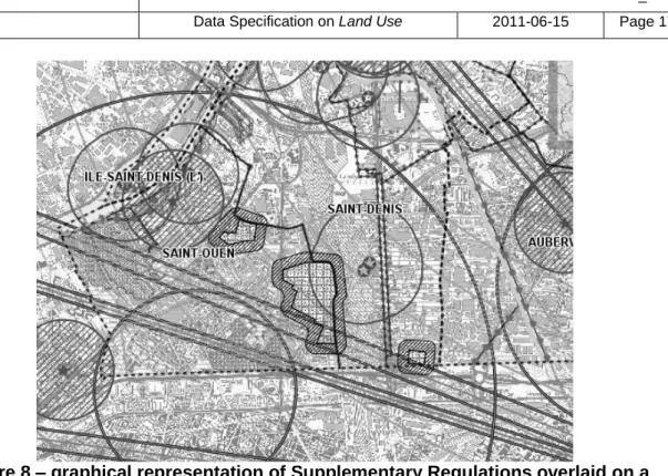
Zoning Plans. At a level of a municipality or group of municipalities (i.e. several hundred of km²), the concepts cartographically represented includes the zoning and supplementary regulations (such as easements) (see figure 3). Zoning refers to a partition where the planned land use is depicted. To each polygon are attached articles of the regulation that explicit the rights and prohibitions regarding new constructions or modification to existing constructions. Supplementary regulations overlap the zoning and provide additional information and/or limitations to the development of the area. The supplementary regulations can be for spatial planning reasons, or due to the need to formalise external regulations. They affect the constructability of cadastral parcels and therefore have ―well-defined‖ boundaries. In the INSPIRE context, they are seen as geographic information.
Figure 3 –examples of cartographic representation of zoning and supplementary
regulations
left: Green lines represent the zoning overlaid on cadastre
right: Supplementary regulations overlaid on cadastre and zoning
Construction Plans. At a development area level (i.e. few km²) the concept cartographically represented are the actual geographical objects that will be created such as building, parking lots, gardens (see figure 4). This detailed level is not really necessary to be exchanged on a European level, but may be exchanged between public authorities at a local level, perhaps even across borders of member states. In the INSPIRE context, they may be seen as geographic information or as simple drawings.
Figure 4 – examples of cartographic representation of planned development area
2.3 Normative References
[Directive 2007/2/EC] Directive 2007/2/EC of the European Parliament and of the Council of 14 March 2007 establishing an Infrastructure for Spatial Information in the European Community (INSPIRE)
[ISO 19108] EN ISO 19108:2005, Geographic Information – Temporal Schema
[ISO 19108-c] ISO 19108:2002/Cor 1:2006, Geographic Information – Temporal Schema, Technical Corrigendum 1
[ISO 19111] EN ISO 19111:2007 Geographic information - Spatial referencing by coordinates (ISO 19111:2007)
[ISO 19113] EN ISO 19113:2005, Geographic Information – Quality principles
[ISO 19115] EN ISO 19115:2005, Geographic information – Metadata (ISO 19115:2003)
[ISO 19118] EN ISO 19118:2006, Geographic information – Encoding (ISO 19118:2005)
[ISO 19123] EN ISO 19123:2007, Geographic Information – Schema for coverage geometry and functions
[ISO 19135] EN ISO 19135:2007 Geographic information – Procedures for item registration (ISO 19135:2005)
[ISO 19138] ISO/TS 19138:2006, Geographic Information – Data quality measures
[ISO 19139] ISO/TS 19139:2007, Geographic information – Metadata – XML schema implementation
[OGC 06-103r3] Implementation Specification for Geographic Information - Simple feature access – Part 1: Common Architecture v1.2.0
NOTE This is an updated version of "EN ISO 19125-1:2006, Geographic information – Simple feature access – Part 1: Common architecture". A revision of the EN ISO standard has been proposed.
[Regulation 1205/2008/EC] Regulation 1205/2008/EC implementing Directive 2007/2/EC of the European Parliament and of the Council as regards metadata
2.4 Terms and definitions
General terms and definitions helpful for understanding the INSPIRE data specification documents are defined in the INSPIRE Glossary14.
Specifically, for the theme Land Use, the following terms are defined: (1) Coverage
Any data representation that assigns values (attributes) directly to a spatial position with regard to spatial, temporal or spatiotemporal aspects. Commonly used coverage includes point sets, grids, collections of closed rectangles and other collections of geometric objects whereas all the geometric objects may exhaustively partition the coverage. A coverage may be a discrete
coverage consisting of a finite collection of geometric objects and the direct positions contained in these geometric objects (e.g. polygons of land use classification) or a continuous coverage which maps direct spatial positions to value records (e.g. raster data that has been
georeferenced).
14
The INSPIRE Glossary is available from
(2) Easements
Rights to use someone else's land for a public utility specified purpose (3) Existing Land Use
An objective depiction of the use and functions of a territory as it has been and effectively still is in real life.
(4) HILUCS
Hierarchical INSPIRE Land Use Classification System; A multi-level classification system for Land Use; its use is mandatory at least for the first level of hierarchy.
(5) Minimum Unit of Interest
The smallest size of the land use objects taken into consideration in the dataset. (6) Planned Land Use
Spatial plans, defined by spatial planning authorities, depicting the possible utilization of the land in the future.
(7) Supplementary regulations
Geographic features which overlap the land use polygons providing supplementary information and/or limitation of the use of land. The supplementary regulations can be for spatial planning reasons or due to the need to formalise external regulations.
(8) Zoning
A partition where the planned land use is depicted. To each polygon articles of the regulation are attached that explicit the rights and prohibitions regarding new constructions
NOTE ―Zoning is an important component of land-use planning. It commonly includes regulation of the kinds of activities which will be acceptable on particular lots (such as open spaces,
residential, agricultural, commercial or industrial), the densities at which those activities can be performed, the amount of space structures may occupy, etc.‖ : Spatial development glossary European Conference of Ministers responsible for Spatial/Regional Planning (CEMAT), http://www.coe.int/t/dg4/cultureheritage/heritage/cemat/VersionGlossaire/Bilingue-en-fr.pdf
2.5 Symbols and abbreviations
ELU Existing Land Use
HILUCS Hierarchical INSPIRE Land Use Classification System MUI Minimum Unit of Interest
PLU Planned Land Use
2.6 Notation of requirements and recommendations
To make it easier to identify the mandatory requirements and the recommendations for spatial data sets in the text, they are highlighted and numbered.
IR Requirement X Requirements that are reflected in the Implementing Rule on interoperability of
spatial data sets and services are shown using this style.
DS Requirement X Requirements that are not reflected in the Implementing Rule on interoperability of spatial data sets and services are shown using this style.
Recommendation X Recommendations are shown using this style.
2.7 Conformance
DS Requirement 1 Any dataset claiming conformance with this INSPIRE data specification shall pass the requirements described in the abstract test suite presented in Annex A.
3 Specification scopes
This data specification has only one scope, the general scope.
4 Identification information
NOTE Since the content of this chapter was redundant with the overview description (section 2) and executive summary, it has been decided that this chapter will be removed in v3.0.
5 Data content and structure
IR Requirement 1 Spatial data sets related to the theme Land Use shall be provided using the
spatial object types and data types specified in the application schema(s) in this section.
IR Requirement 2 Each spatial object shall comply with all constraints specified for its spatial object type or data types used in values of its properties, respectively.
Recommendation 1 The reason for a void value should be provided where possible using a listed value from the VoidValueReason code list to indicate the reason for the missing value.
NOTE The application schema specifies requirements on the properties of each spatial object including its multiplicity, domain of valid values, constraints, etc. All properties have to be reported, if the relevant information is part of the data set. Most properties may be reported as ―void‖, if the data set does not include relevant information. See the Generic Conceptual Model [INSPIRE DS-D2.5] for more details.
5.1 Basic notions
This section explains some of the basic notions used in the INSPIRE application schemas. These explanations are based on the GCM [DS-D2.5].
5.1.1 Stereotypes
In the application schemas in this sections several stereotypes are used that have been defined as part of a UML profile for use in INSPIRE [INSPIRE DS-D2.5]. These are explained in Table 1 below.
Table 1 – Stereotypes (adapted from [INSPIRE DS-D2.5])
Stereotype Model
element Description
applicationSchema Package An INSPIRE application schema according to ISO 19109 and the Generic Conceptual Model.
featureType Class A spatial object type.
type Class A conceptual, abstract type that is not a spatial object type. dataType Class A structured data type without identity.
union Class A structured data type without identity where exactly one of the properties of the type is present in any instance.
enumeration Class A fixed list of valid identifiers of named literal values. Attributes of an enumerated type may only take values from this list.
codeList Class A flexible enumeration that uses string values for expressing a list of potential values.
placeholder Class A placeholder class (see definition in section 5.1.2).
voidable Attribute,
association role
A voidable attribute or association role (see definition in section 5.1.3).
lifeCycleInfo Attribute, association role
If in an application schema a property is considered to be part of the life-cycle information of a spatial object type, the property shall receive this stereotype.
version Association
role
If in an application schema an association role ends at a spatial object type, this stereotype denotes that the value of the property is meant to be a specific version of the spatial object, not the spatial object in general.
5.1.2 Placeholder and candidate types
Some of the INSPIRE Annex I data specifications (which were developed previously to the current Annex II+III data specifications) refer to types that thematically belong and were expected to be fully specified in Annex II or III spatial data themes. Two kinds of such types were distinguished:
Placeholder types were created as placeholders for types (typically spatial object types) that were to be specified as part of a future spatial data theme, but which was already used as a value type of an attribute or association role in this data specification.
Placeholder types received the stereotype «placeholder» and were placed in the application schema package of the future spatial data theme where they thematically belong. For each placeholder, a definition was specified based on the requirements of the Annex I theme. The Annex II+III TWGs were required to take into account these definitions in the specification work of the Annex II or III theme.
If necessary, the attributes or association roles in the Annex I data specification(s) that have a placeholder as a value type shall be updated if necessary.
Candidate types were types (typically spatial object types) for which already a preliminary specification was given in the Annex I data specification. Candidate types did not receive a specific stereotype and were placed in the application schema package of the future spatial data theme where they thematically belong. For each candidate type, a definition and attributes and association roles were specified based on the requirements of the Annex I theme. The Annex II+III TWGs were required to take into account these specifications in the specification work of the Annex II or III theme.
If the type could not be incorporated in the Annex II or III data specification according to its preliminary specification, it should be moved into the application schema of the Annex I theme where it had first been specified. In this case, the attributes or association roles in the Annex I data specification(s) that have the type as a value type shall be updated if necessary.
Open issue 1: For all Annex II+III themes for which placeholders and candidate types were specified in an Annex I data specification, it should be clearly indicated in the data specification, how the placeholder and candidate types were taken into account. If the proposed solution would require any changes to an Annex I data specification (and the corresponding section in the IR for interoperability of spatial data sets and services), this should also be clearly indicated.
A thorough investigation of the implications of the proposed changes of candidate types (in particular related to requirements of Annex I maintenance) will have to be performed for v3.0 of the data specifications.
5.1.3 Voidable characteristics
If a characteristic of a spatial object is not present in the spatial data set, but may be present or applicable in the real world, the property shall receive this stereotype.
If and only if a property receives this stereotype, the value of void may be used as a value of the property. A void value shall imply that no corresponding value is contained in the spatial data set maintained by the data provider or no corresponding value can be derived from existing values at reasonable costs, even though the characteristic may be present or applicable in the real world. It is possible to qualify a value of void in the data with a reason using the VoidValueReason type. The VoidValueReason type is a code list, which includes the following pre-defined values:
Unpopulated: The characteristic is not part of the dataset maintained by the data provider. However, the characteristic may exist in the real world. For example when the ―elevation of the water body above the sea level‖ has not been included in a dataset containing lake spatial objects, then the reason for a void value of this property would be ‗Unpopulated‘. The characteristic receives this value for all objects in the spatial data set.
Unknown: The correct value for the specific spatial object is not known to, and not computable by the data provider. However, a correct value may exist. For example when the ―elevation of the water body above the sea level‖ of a certain lake has not been measured, then the reason for a void value of this property would be ‗Unknown‘. This value is applied on an object-by-object basis in a spatial data set.
NOTE It is expected that additional reasons will be identified in the future, in particular to support reasons / special values in coverage ranges.
The «voidable» stereotype does not give any information on whether or not a characteristic exists in the real world. This is expressed using the multiplicity:
If a characteristic may or may not exist in the real world, its minimum cardinality shall be defined as 0. For example, an if an Address may or may not have a house number, the multiplicity of the corresponding property shall be 0..1.
If at least one value for a certain characteristic exists in the real world, the minimum cardinality shall be defined as 1. For example, if an Administrative Unit always has at least one name, the multiplicity of the corresponding property shall be 1..*.
In both cases, the «voidable» stereotype can be applied. A value (the real value or void) only needs to be made available for properties that have a minimum cardinality of 1.
5.1.4 Code lists and Enumerations
5.1.4.1. Style
All code lists and enumerations use the following modelling style: No initial value, but only the attribute name part, is used.
The attribute name conforms to the rules for attributes names, i.e. is a lowerCamelCase name. Exceptions are words that consist of all uppercase letters (acronyms).
5.1.4.2. Governance of code lists
Two types of code lists are defined in INSPIRE. These two types are distinguished using the tagged value ―extendableByMS‖ in the UML data model:
Code lists that may not be extended by Member States. For these code lists, the tagged value is set to ―false‖. They shall be managed centrally in the INSPIRE code list register, and only values from that register may be used in instance data.
Code lists that may be extended by Member States. For these code lists, the tagged value is set to ―true‖.
5.2 Application schema Land Use
5.2.1 Description
5.2.1.1. Narrative description and UML overview
There is a multitude of different ways to describe land use. This is partly due to the wide range of aspects of the functional use of land embraced by land use (including both existing land use and planned land use), partly due to the versatility of the land use data, and partly due to the confusion between land use and land cover in existing datasets. There is only one "real world" but many different descriptions of this world circulate (depending on the aims, methodology and terminology of the observer). A common application schema cannot support all uses across all computer environments. Therefore many, sometimes incompatible, ways of describing land use will continue to exist. Land use classification starts from a universe of discourse – ―the real world‖. This universe is analyzed according to a set of rules in order to establish a classification system. A selected list of classes, also named LUTypes (possibly parameterized) from the classification system, generates a nomenclature (analogous to a Feature catalogue) as part of any particular Application schema.
Different classification systems can be matched and compared when they are well documented. The solution used in this INSPIRE data specification is therefore to create an application schema (named Land Use) that defines feature types but is as open ended as possible with respect to particular classification systems. This approach assures that a wide range of data based on different land use classification systems can co-exist in INSPIRE, as long as these systems are sufficiently well documented. The model provides mechanisms to document several classification systems. In order to allow progress in the area of semantic interoperability, i.e. the capacity to compare datasets natively connected to various classification systems, the model proposes a hierarchical INSPIRE Land Use classification system (HILUCS), general enough to allow any Land Use feature to be linked to a Land use type from the classification system. This applies to both the existing and the planned land use. This HILUCS is hierarchical in order to allow semantic generalisation and flexibility.
For building the Land Use application schema a core model is first defined for Land Use (see section 5.2.1.1.1). The specialisation of the core model defines the existing land use model (see section
5.2.1.1.2) and the planned land use model (see section 5.2.1.1.3). The HILUCS principles are then presented (see section 5.2.1.1.4)
5.2.1.1.1. Core model
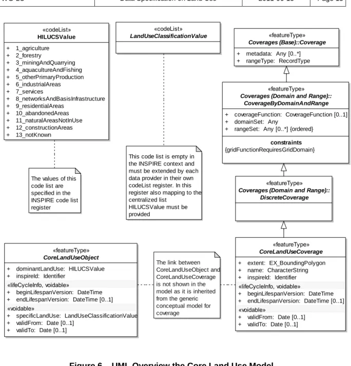
The core model for Land Use corresponds to a Land Use dataset that covers an area and provides a partition of that area with polygons (either vector of raster) that are mutually exclusive and collectively exhaustive, i.e. they cover the whole area (see Figure 5). The area covered by a Land Use data set may differ from the area managed by an authority due to multiple reasons including the data capture method (e.g. from imagery) or the legal context. The core model also corresponds to a Land Use dataset that provide Land use information attached to a discrete set of location (samples) as shown in Figure 5. These polygons and locations are named CoreLandUseObject in the UML overview in Figure 6. Each of them is described by a dominant land use category. The covered area can be irregularly shaped and multipart.
LandUse type A LandUse type B LandUse type C LandUse type D LandUse type E LandUse type F LandUse type G LandUse type H LandUse type I LandUse type J LandUse type K
Figure 5 – showing three types of datasets containing Land use information:
Top left polygons overlaid on an orthophotography,
Top right pixels overlaid on administrative boundaries and water bodies,
Down left set of discrete location,
«codeList» HILUCSValue + 1_agriculture + 2_forestry + 3_miningAndQuarrying + 4_aquacultureAndFishing + 5_otherPrimaryProduction + 6_industrialAreas + 7_services + 8_networksAndBasisInfrastructure + 9_residentialAreas + 10_abandonedAreas + 11_naturalAreasNotInUse + 12_constructionAreas + 13_notKnown
This code list is empty in the INSPIRE context and must be extended by each data provider in their own codeList register. In this register also mapping to the centralized list
HILUCSValue must be provided
The values of this code list are specified in the INSPIRE code list register «codeList» LandUseClassificationValue «featureType» CoreLandUseCoverage + extent: EX_BoundingPolygon + name: CharacterString + inspireId: Identifier «lifeCycleInfo, voidable» + beginLifespanVersion: DateTime + endLifespanVersion: DateTime [0..1] «voidable» + validFrom: Date [0..1] + validTo: Date [0..1] «featureType» CoreLandUseObject + dominantLandUse: HILUCSValue + inspireId: Identifier «lifeCycleInfo, voidable» + beginLifespanVersion: DateTime + endLifespanVersion: DateTime [0..1] «voidable» + specificLandUse: LandUseClassificationValue + validFrom: Date [0..1] + validTo: Date [0..1] «featureType»
Coverages (Domain and Range):: DiscreteCoverage
«featureType»
Coverages (Domain and Range):: CoverageByDomainAndRange
+ coverageFunction: CoverageFunction [0..1] + domainSet: Any
+ rangeSet: Any [0..*] {ordered} constraints {gridFunctionRequiresGridDomain} «featureType» Coverages (Base)::Coverage + metadata: Any [0..*] + rangeType: RecordType
The link between CoreLandUseObject and CoreLandUseCoverage is not shown in the model as it is inherited from the generic conceptual model for coverage
Figure 6 – UML Overview the Core Land Use Model
and the Land Use classification systems
The core model enables the assignment to each polygon or location of a land use category (attribute dominantLandUse of the «featureType» CoreLandUseObject in the UML overview in Figure 6) from the hierarchical INSPIRE Land Use classification system (HILUCS, see section 5.2.1.1.4). HILUCS will gradually evolve in a consistent way. The responsible body guiding this evolution is yet to be defined. The objective is to move towards a stable classification system at the European level. In order to ensure a minimum level of interoperability, it is mandatory to use the first level of HILUCS.
IR Requirement 1 Any Land use Datasets shall assign to each CoreLandUseObject a land
use type from the Hierarchical INSPIRE Land Use Classification System (HILUCS) at least at the level 1 of the hierarchy.
The mandatory HILUCS level 1 will allow to consistently visualise datasets from diverse sources with the same legend.
The core model also enables the assignment of a land use category (specificLandUse in the UML overview in Figure 6) from at least one classification system that is stable and well-defined either at an international (such as SEEA from the UN, LUCAS from Eurostat), national or local level. Mapping such a specific land use classification system with HILUCS will improve interoperability. Examples of such mapping is provided in annex C
LandUseClassificationSystemValue has a data type «codeList» in order to connect to a register managed by the member states.
IR Requirement 2 The authority managing a specificLandUse Classification system should
document a mapping with the Hierarchical INSPIRE Land Use Classification System (HILUCS).
The CoreLandUseObject are grouped in a coverage («featureType» CoreLandUseCoverage in the UML overview in Figure 6). Coverage inherits the properties from the coverage («featureType» CoverageByDomainAndRange) that is described in the INSPIRE document Proposed Changes to the Generic Conceptual Model and Encoding Guidelines. Only the following subtypes of CoverageByDomainAndRange are permitted: MultiPointCoverage, MultiSurfaceCoverage and GridCoverage.
IR Requirement 3 The «featureType» CoverageByDomainAndRange must only be of subtypes
MultiPointCoverage, MultiSurfaceCoverage or GridCoverage The definitions below are exported from the above mentioned document:
CoverageByDomainAndRange: coverage which provides the domain and range as separate properties.
MultiPointCoverage: coverage characterized by a finite domain consisting of points. Usually the domain is a set of irregularly distributed points
MultiSurfaceCoverage: coverage whose domain consists of a collection of surfaces. In most cases, the surfaces that constitute the domain are mutually exclusive and exhaustively partition the extent of the coverage. Surfaces or their boundaries may be of any shape. GridCoverage : coverage whose domain consists of a collection of grid points
Open issue 2: The use of the «featureType» CoverageByDomainAndRange (described in document ‗Proposed Changes to the Generic Conceptual Model and Encoding Guidelines‟) is limited to MultiPointCoverage, MultiSurfaceCoverage and GridCoverage sub-types. One can argue that their implementation is not fully supported by current software. The Testing process may end up with a recommendation of simplifying the MultiSurfaceCoverage by an "old-fashioned" polygon overlay mechanism.
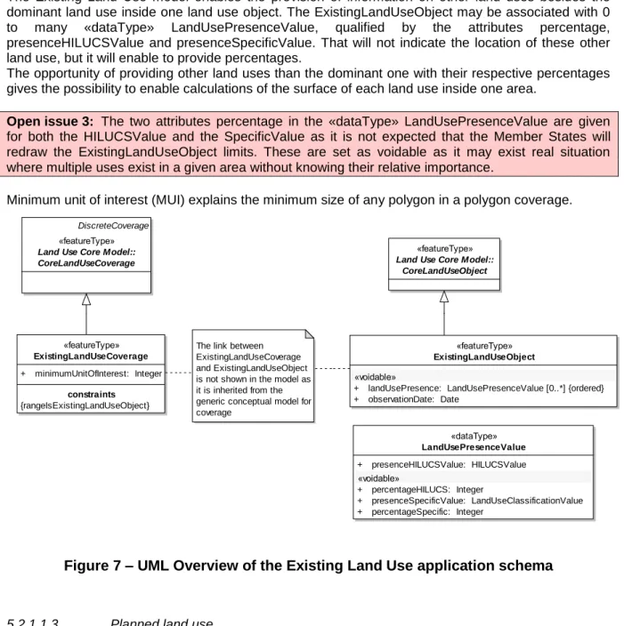
5.2.1.1.2. Existing land use
The Existing Land use model corresponds to a dataset that depicts the reality of the land surface at a certain point or period in time. Usage of dataset depicting existing land use may require providing information on the same piece of land at different time. The model does not implement this requirement. It means that the existing land use on the same area at two different times will be provided as two different datasets.
The «featureType» ExistingLandUseCoverage inherits properties from the CoreLandUseCoverage defined in the Land Use Core Model as well as the ExistingLandUseObject inherits from the CoreLandUseObject. Thus the link between the coverage and the land use objects is implemented by the constraints {rangeIsExistingLandUseObject} (see UML overview in Figure 7).
A coverage may be created from several sources. Thus each land use object may be associated with the time the documented land use corresponds to (attribute observationDate of «featureType» ExistingLandUseObject in Figure 7).


![Table 1 – Stereotypes (adapted from [INSPIRE DS-D2.5])](https://thumb-us.123doks.com/thumbv2/123dok_us/9647064.2844846/20.892.105.808.56.782/table-stereotypes-adapted-inspire-ds-d.webp)