University of Tennessee, Knoxville
Trace: Tennessee Research and Creative
Exchange
Masters Theses Graduate School
8-2011
Design and Implementation of an Object-Oriented
Space-Time GIS Data Model
Ziliang Zhao
University of Tennessee - Knoxville, [email protected]
This Thesis is brought to you for free and open access by the Graduate School at Trace: Tennessee Research and Creative Exchange. It has been accepted for inclusion in Masters Theses by an authorized administrator of Trace: Tennessee Research and Creative Exchange. For more information,
Recommended Citation
Zhao, Ziliang, "Design and Implementation of an Object-Oriented Space-Time GIS Data Model. " Master's Thesis, University of Tennessee, 2011.
To the Graduate Council:
I am submitting herewith a thesis written by Ziliang Zhao entitled "Design and Implementation of an Object-Oriented Space-Time GIS Data Model." I have examined the final electronic copy of this thesis for form and content and recommend that it be accepted in partial fulfillment of the requirements for the degree of Master of Science, with a major in Geography.
Shih-Lung Shaw, Major Professor We have read this thesis and recommend its acceptance:
Bruce Ralston, Liem Tran
Accepted for the Council: Dixie L. Thompson Vice Provost and Dean of the Graduate School (Original signatures are on file with official student records.)
Design and Implementation of an Object-Oriented
Space-Time GIS Data Model
A Thesis Presented for the
Master of Science
Degree
The University of Tennessee, Knoxville
Ziliang Zhao
August 2011
Copyright © 2011 by Ziliang Zhao All rights reserved.
ACKNOWLEDGEMENTS
I am grateful to my advisor, Dr. Shih-Lung Shaw, for his continuous and patient guidance and support on my study. The research idea of this research came originally from Dr. Shaw. I further explored and implemented this idea in the past 2 years through numerous meetings with Dr. Shaw. He also helped me a lot on thesis writing, which turned me from a pure technician toward a serious researcher. Although my work is still not perfect, I am already on the right track.
Many thanks go to Dr. Bruce Ralston and Dr. Liem Tran. They always offered me help and suggestions. The knowledge I gained from Dr. Ralston and Dr. Tran was beneficial to the model design and prototype system development in my thesis research.
I really appreciate my parents and grandparents in China. Although they could not help me on my research, their warm and valuable encouragements support me to reach this point.
ABSTRACT
Geographic data are closely related to both spatial and temporal domains. Geographic information systems (GIS) can capture, manage, analyze, and display spatial data. However, they are not suitable for handling temporal data. Rapid developments of data collection and location-aware technologies stimulate the interests of obtaining useful information from the historical data. Researchers have been working to build various spatio-temporal data models to support spatio-temporal query. Nevertheless, the existing models exhibit weaknesses in various aspects. For instance, the snapshot model is plagued with data redundancy and the event-based spatio-temporal data model (ESTDM) is limited to raster dataset. This study reviews existing spatio-temporal data models in order to design an object-oriented space-time GIS data model that makes additional contributions to processing spatio-temporal data. A binary large object (BLOB) data type, labeled Space-Time BLOB, is added to ArcGIS geodatabase data model to store instantiated space-time objects. A Space-Time BLOB is associated with an array that contains the spatial and temporal information for an object at different time points and time intervals. This study also implements a space-time GIS prototype system, along with a set of spatio-temporal query functions, based on the proposed space-time GIS data model.
TABLE OF CONTENTS
Chapter 1 Introduction ... 1
1.1 Research Background ... 1
1.1.1 Time as an essential property ... 1
1.1.2 Relationships between space and time ... 2
1.1.3 The need to address spatio-temporal queries related to both space and time .... 2
1.1.4 The limited capability of the current space-time GIS data model in addressing spatio-temporal queries ... 3
1.2 Research Objectives and Research Questions ... 4
1.2.1 Research objectives ... 4
1.2.2 Research questions ... 4
1.3 Organization of the Thesis ... 5
Chapter 2 Literature Review... 6
2.1 Spatio-temporal Query ... 6
2.2 Spatio-temporal Data Models ... 8
2.2.1 The snapshot model ... 10
2.2.2 The simple time-stamping model... 11
2.2.3 The space-time composite model... 12
2.2.4 The amendment model ... 14
2.2.5 The grid model ... 14
2.2.6 Event-based spatio-temporal data model (ESTDM) ... 15
2.2.7 Three-domain model ... 16
2.2.8 Object-oriented model ... 17
2.2.9 The extended dynamic GIS model (EDGIS) ... 18
2.2.10 ESRI parcel model ... 19
2.2.11 The TimeObject in the national cooperative highway research program (NCHRP) and other types of time ... 21
2.3 Spatio-temporal Visualization ... 23
2.4 Moving Objects Database ... 24
Chapter 3 An Object-Oriented Space-Time GIS Data Model ... 27
3.1 Relevant Conceptualization of Space and Time ... 27
3.1.1 The prevalence of the snapshot model and its limitation ... 27
3.1.2 Object-oriented view of space and time... 28
3.2 Design of the Object-oriented Space-Time Class ... 29
3.3 Creation of Space-Time Object ... 33
3.3.1 Creation of Space-Time BLOB for snapshots with entity identity ... 33
3.3.2 Incorporation of new data into the Space-Time BLOB of object with entity identity ... 37
3.3.3 Creation of Space-Time BLOB for snapshots without entity identity ... 39
3.3.4 Incorporation of new data into the Space-Time BLOB of object without entity identity ... 41
3.4 Storage of the Space-Time BLOB ... 42
Chapter 4 A Space-Time GIS Prototype System... 44
4.2 System Overview ... 47
4.3 Tools for Space-Time BLOB Creation in Geodatabase ... 48
4.3.1 Data Preparation before processing ... 48
4.3.2 Tools to Create Space-Time BLOB for snapshots with entity identity ... 49
4.3.3 Tools to Create Space-Time BLOB for snapshots without entity identity ... 52
4.4 Functions of Spatial-temporal Query ... 57
4.4.1 Interface design of Spatio-temporal query ... 57
4.4.2 What -> When + Where ... 58
4.4.3 When -> What + Where ... 60
4.4.4 Where -> What + When ... 62
4.4.5 What + When -> Where ... 63
4.4.6 What + Where -> When ... 63
4.4.7 Where + When -> What ... 65
Chapter 5 Conclusions ... 67
5.1 Summary of the Study ... 67
5.2 Future Research Directions ... 68
5.2.1 Incorporating other forms of time ... 68
5.2.2 System implementation for point, polyline and raster ... 69
5.2.3 Incorporation with analytical time-geographic framework ... 70
5.2.4 Spatio-temporal analysis ... 70
5.2.5 Processing power on very large dataset ... 70
REFERENCES ... 72
LIST OF TABLES
Table Page
Table 2.1 Sinton's measurement framework (Sinton 1978) ... 8 Table 2.2 Classification of spatio-temporal data model ... 9 Table 3.1 The generated table of greatest common units ... 40
LIST OF FIGURES
Figure 2.1 Temporal topology ... 7
Figure 2.2 Snapshot model ... 11
Figure 2.3 The time tab in the layer properties dialog in ArcMap 10 ... 12
Figure 2.4 The space-time composite model ... 13
Figure 2.5 The amendment model ... 15
Figure 2.6 The grid model ... 15
Figure 2.7 Event-based spatio-temporal data model ... 16
Figure 2.8 Object-oriented model ... 18
Figure 2.9 The data structure of EDGIS ... 19
Figure 2.10 ESRI parcel model ... 20
Figure 2.11 Time object in NCHRP 20-27(3) ... 22
Figure 2.12 Different types and structures of time ... 22
Figure 2.13. Four representation methods in ESTAT ... 24
Figure 3.1 The UML diagram of the proposed space-time GIS design ... 30
Figure 3.2 The flowchart of creating Space-Time BLOBs for snapshots with entity identity ... 34
Figure 3.3 The flowchart of incorporating new data into Space-Time BLOBs with entity identity ... 38
Figure 3.4 An example of generating greatest common units ... 40
Figure 3.5 The process of serialization ... 43
Figure 4.1 Historical Chinese province maps ... 45
Figure 4.2 Historical land use parcels on UT campus ... 46
Figure 4.3 The interface of the prototype system ... 48
Figure 4.4 The organization of the space-time Geodatabase ... 50
Figure 4.5 The tab of Space-Time BLOB creation ... 50
Figure 4.6 Beijing’s Space-Time Point in 1953... 51
Figure 4.7 Beijing’s Space-Time Interval from 1964 to 2000 ... 51
Figure 4.8 Chongqing’s Space-Time Point in 2000... 53
Figure 4.9 Fujian’s Space-Time Interval from 1953 to 2000 ... 53
Figure 4.10 Heilongjiang’s Space-Time Point in 1953 ... 53
Figure 4.11 Heilongjiang’s Space-Time Point in 1964 ... 53
Figure 4.12 Heilongjiang’s Space-Time Point in 1982 ... 53
Figure 4.13 Heilongjiang’s Space-Time Point in 1990 ... 53
Figure 4.14 Heilongjiang’s Space-Time Point in 2000 ... 54
Figure 4.15 The generated greatest common units ... 54
Figure 4.16 An example of a greatest common unit with a Space-Time Interval from 1998 to 2008 ... 55
Figure 4.17 Another example of a greatest common unit with a Space-Time Interval from 1998 to 2003 and a Space-Time Point in 2008 ... 56
Figure 4.18 An example of the lineage of a greatest common unit ... 56
Figure 4.19 Another example of the lineage of a greatest common unit ... 58
Figure 4.20 Interface design of spatio-temporal query ... 58
Figure 4.22 The settings of spatio-temporal query “What -> When + Where” ... 60
Figure 4.23 The result of spatio-temporal query “What -> When + Where” ... 60
Figure 4.24 The settings of spatio-temporal query “What -> When + Where” ... 60
Figure 4.25 The result of spatio-temporal query “What -> When + Where” ... 61
Figure 4.26 The settings of spatio-temporal query “When -> What + Where” ... 62
Figure 4.27 The result of spatio-temporal query “When -> What + Where” ... 62
Figure 4.28 The settings of spatio-temporal query “Where -> What + Where” ... 63
Figure 4.29 The result of spatio-temporal query “Where -> What + When” ... 64
Figure 4.30 The settings of spatio-temporal query “What + When -> Where” ... 64
Figure 4.31 The result of spatio-temporal query “What + When -> Where” ... 64
Figure 4.32 The settings of spatio-temporal query “What + Where -> When” ... 65
Figure 4.33 The result of spatio-temporal query “What + Where -> When” ... 66
Figure 4.34 The settings of spatio-temporal query “Where + When -> What” ... 66
CHAPTER 1
INTRODUCTION
Both space and time are key properties of geographic data. Geographic information systems (GIS) handle the spatial domain of the geographic data very well in data management, data analysis, and data visualization. However, it is well known that GIS have very limited capabilities in answering the question with temporal domain, such as “how does the boundary of Beijing change over time.” The goal of this study is to design a space-time GIS model to organize the spatio-temporal data in a way so that certain kinds of spatio-temporal queries could be easily addressed. Chapter 1 presents research background, research questions, and objectives. The organization of the thesis is outlined at the end this chapter.
1.1 Research Background
This section demonstrates the background of the research. The importance of time and its relationship with space is clarified first, followed by the need to answer different types of questions related to both space and time based upon spatio-temporal dataset. How current GIS can do this and its limitations are also discussed.
1.1.1 Time as an essential property
Everything in the universe is associated with time, whether that “thing” is tangible or intangible. Tangibles are substances that we can see, touch, and feel; they exist everywhere in the world. Human beings are a typical example of this category in that they possess substance, and experiences like birth, graduation, marriage, death can all be stamped with time. One may not remember the exact times of these events, but they do exist. Land use parcel is another example of tangibles that change over time. When people enter the parcel transactions in the database, for example, parcel owner change, the subdividing of a piece of property, the time when these transaction take place must be recorded.
Intangibles do not physically exist in the real world, but they are closely related to our lives, usually referring to activities or events. An activity is a process, such as a colloquium in the Geography Department, which is associated with a start time and an end time. An event is an occurrence or an outcome that has significance. We refer to an event when we encounter an old friend on the way to class. An event can sometimes be the start or end of an activity, and it sometimes triggers another, subsequent,
activity. The submission of an order to Amazon is an event and triggers the packaging and shipment of the ordered items.
1.1.2 Relationships between space and time
In fact, the data we capture in the real world are closely related to both spatial and
temporal domains because things change in space over time (Peuquet 2002). Most living things, such as human beings, keep changing location in order to conduct different activities to meet their needs. The position at one time point is probably not the same as the location at the next. Non-living things may move through time, or may not. The former involves vehicles, satellites, and so forth. The latter includes buildings, land parcels, and so on. In this case, even if the position could be consistent, properties such as physical existence and attributes change through time: a new building could be
dismantled after fifty years; a land parcel’s appraisal might change frequently (Arctur and Zeiler 2004).
However, a large number of GIS students and experts pay attention only to the spatial representation without realizing the importance of the temporal information. When using a digital map for analysis in the GIS lab class, very few students would ask at what time the features in the map were captured and digitized. The majority of students take for granted that the data they use represent the “correct” state of the world, while in fact this assumption might not be correct even if the data is the latest released version. Thus, the conclusions drawn from the spatial analysis might be inaccurate.
In short, space and time are both key properties possessed by each object in our world. On the one hand, if we ignore space, we lose the most significant geographic information, that is, location. On the other hand, if we ignore time, we cannot understand when a particular state exists or when a spatial change takes place, making location information less meaningful.
1.1.3 The need to address spatio-temporal queries related to both space and time
Many people are very interested in the performing queries in order to find historical information. They expect GIS to provide the answer not only in spatial, but also in temporal domains. Consider the following scenarios.
A historian uses GIS to study the historical change of Chinese province boundaries. He has the static maps of Chinese province boundaries in each year during 1950 to 2000, suggesting about 50 layers in total. To study the stability of Chinese province, the historian is curious about how many provinces had boundary changes between 1950 and 1960, 1960 and 1970, and so forth. He is also interested in how Rehe Province changed in 1950s, what adjacent provinces merged its land after Rehe Province was removed. Also, the historian wants to know how Beijing’s boundary changed over time and what adjacent provinces were influenced.
In the past 20 years, Knox County Metropolitan Planning Commission (MPC) has been maintaining the land use data in Knox County. A land use analyst obtains this dataset in order to study the land use change in Knox County in the past 20 years. He wants to know how many land use parcels changed from residential to commercial between 2000
and 2005. Among these parcels, which changed back to commercial land parcel again in 2008 and were these land use type changes associated with land owner changes?
These are two typical examples which illustrate that the information many people are interested in are related to the temporal domain. In fact, such spatio-temporal query capability could benefit many other areas, such as human migration, environmental evolution, and so forth.
In recent years, developments in data collection technologies have produced huge
amounts of spatio-temporal datasets. Compared with previous decades, people now have more and more spatio-temporal data, which enable researchers to dig out hidden
information accumulated over time to unveil the changes, patterns, and processes. Therefore, the needs for powerful spatio-temporal query functions are even stronger.
1.1.4 The limited capability of the current space-time GIS data model in addressing spatio-temporal queries
GIS can capture, manage, analyze, and display spatial data. However, they are not well suited for handling data with temporal domain. The most prevalent and widely applied is the snapshot data model (Armstrong 1988). This model is simple and easy to use. To address the foregoing mentioned spatio-temporal queries, people often use snapshot model in commercial GIS packages, such as ArcGIS. Snapshots which represent the states of the study area at different times are stacked as layers. People have to extract relevant information layer by layer. After then, they have to compare the objects from consecutive time points to determine if changes occur. Since snapshot model does not explicitly maintain the information about how things change over time, people have to do it manually. Imagine if one has 10,000 layers, answering the questions, such as “how did object A change” leads to tremendous workload. Even if a script could be developed to automate this process, selecting and comparing objects layer by layer is inefficient. From the data storage perspective, snapshot model has data redundancy problem. In the land use scenario, each land parcel has to be recorded again and again, even if no change occurs on this parcel during that time. Therefore, the data redundancy could be huge when people try to use snapshot model to record relatively stable area every short period. Researchers have made considerable effort to design new space-time GIS data models to replace the snapshot model, such as event-based, object-oriented, and three-domain models. Nevertheless, existing models exhibit weaknesses, such as data redundancy, implementation difficulties, and so forth. Moreover, in most studies, the proposed space-time GIS models only deal with hypothetical data. Their ability to handle large real-world historical dataset is questionable. In summary, current space-time GIS data models are far from satisfactory. Snapshot model is still the dominant one.
1.2 Research Objectives and Research Questions
A series of research challenges are involved in this study. In this section three major objectives of this study are listed. To achieve these objectives, five research questions are also identified and discussed.
1.2.1 Research objectives
The proposed study aims to pursue three main research objectives: (1) design a space-time GIS model to store the spatio-temporal data to facilitate the capability and
performance on certain spatio-temporal queries, such as how does an object change over time. This data model would be object-oriented which explicitly records the spatio-temporal change of the object. Using this model, an object does not need to be recorded if no change occurs; (2) to design a workflow to organize historical data which have been accumulated for some time, as well as a workflow to incorporate new data. Object with or without entity identity are both considered; (3) to implement a prototype system based on the designed data model, which includes the automatic historical data processing (i.e., automatically loads objects from snapshots into Geodatabase), the storage of the space-time objects, and the establishment of spatio-temporal query functions.
1.2.2 Research questions
The following research questions are addressed to achieve the above objectives:
1. Spatio-temporal queries: Peuquet (Peuquet 1994) suggested three types of spatio-temporal queries: “when + where what,” “when + what where,” and “where + what when.” In addition, the following three types of spatio-temporal queries are possible: (a) “when what + where,” (b) “what when + where,” and (c) “where what + when.” In these queries, only one of the components is controlled so more results could fit the requirement. For instance, when
conducting the “when what + where” query on travel diary data, the system may generate a list indicating all individuals (what) and their corresponding locations (where) at the given time. A sound and efficient space-time GIS data model enables powerful spatio-temporal query functions. What information should be maintained in the proposed space-time GIS data model so that the change of objects over time could be tracked? How can a proper user interface be designed to facilitate spatio-temporal queries?
2. Time representation in GIS: The traditional snapshot model records the objects at a given time point. To reduce data redundancy, time interval is introduced. How can we integrate time interval and use it in conjunction with time point to
represent temporal information?
3. Management of different types of historical data: There are two kinds of historical spatio-temporal data. One is with entity identity, such as the historical Chinese province maps. The other is without entity identity, such as the land use data.
The key difference is that an object with entity identity is associated with a persistent ID that distinguishes one object from another, while the object without entity identity simply occupies some space in the real world within which the attributes are the same. How can we preserve the spatio-temporal information for both types of object? What do the differences of object with/without entity identity imply in the space-time GIS data model design? Can we use the same mechanism for both situations?
4. Storage and access of space-time objects: After creating a space-time object using the proposed data model, it must be stored for future access and analysis. How can this space-time object be transferred to a binary file and stored in the Geodatabase? How can the binary file be resurrected back into a space-time object when needed?
1.3 Organization of the Thesis
This thesis is organized into five chapters. Chapter 2 reviews the literature covering what have been done related to this study, including temporal data models, spatio-temporal query and other related topics. In Chapter 3, the limitation of the dominant space-time GIS data model, snapshot model, is discussed, followed by the idea of object-oriented view of space and time. This chapter also illustrates the design of the proposed object-oriented space-time GIS data model, as well as the workflows to organize and maintain the spatio-temporal data based upon the suggested model. Chapter 4 demonstrates the implemented prototype system: organizing historical data using the proposed object-oriented space-time GIS data model, accessing and interpreting the spatio-temporal information, conducting spatio-temporal queries and understanding the result. Chapter 5 summarizes the achievements and contributions of this study. This study serves as an important part of ongoing development of a comprehensive space-time GIS framework led by my advisor, Dr. Shih-Lung Shaw.
CHAPTER 2
LITERATURE REVIEW
A GIS serves as a powerful platform for dealing with spatial data. However, it lacks the ability to handle temporal information. Goodchild (1992) posed several challenges that constituted important research areas in geographic information science. Among these challenges is the modeling of time-dependent data. Some research has actively focused on this area, and many creative approaches have been proposed during the past two decades.
It should be noted that there is no perfect data model. Each spaito-temporal data model exhibits strengths when answering certain types of spatio-temporal query, while for other types of queries it might be inefficient. This chapter starts from spatio-temporal query, followed by the review of several data models which are used to support the query. Spatio-temporal visualization which could be used to better demonstrate the result is also discussed in this chapter.
2.1 Spatio-temporal Query
Spatio-temporal query dig out information from the spatio-temporal dataset and provide useful information to the user. The capability of spatio-temporal query varies in terms of the underlying spatio-temporal data model. This section discusses several topics relevant to spatio-temporal query.
The most important feature that distinguishes a spatio-temporal query from traditional spatial query in current commercial GIS package is that a spatio-temporal query contains a temporal component, which is either specified in the condition or reflected from the result. When constructing the spatial component, people use spatial topology to specify the location with reference to a known position, such as “within 100 meters of I-40,” “inside the Knox County.” This is very similar to specifying the temporal component. Allen (1984) proposed a temporal topology, including seven temporal relations: before, equal, meets, overlaps, during, starts, and ends (Figure 2.1). These seven scenarios are used to describe the conditions of temporal information when performing queries. In this thesis research, the prototype system is able to select all objects whose times of existence “overlap” or “during” the specified start and end times. In overlap relationship, the object with start time or end time of the existence between the specified time period would be selected, while the object with start time and end time both between the specified period would be selected in the “during” relationship. The mechanism of spatio-temporal query with temporal relationships other than “overlap” and “during” can be implemented by comparing the start time and end time that an object exists with the specified time period in different ways.
Figure 2.1 Temporal topology (Allen 1984)
Spatio-temporal queries are composed in different forms. Peuquet (1994) classified data types into three categories: where, when, and what. Accordingly, any spatio-temporal query can be categorized into one of the following types of questions:
(1) when + where what (2) when + what where (3) where + what when
This thesis research extends this classification by incorporating the following three types of spatio-temporal queries:
(1) what when + where (2) when what + where (3) where what + when
Sinton (1978) proposed a framework for spatio-temporal query. In Sinton’s framework, location, time, and attribute are treated as “fixed,” “controlled,” and “measured”
components, respectively (Table 2.1). Six types of spatio-temporal queries were suggested in terms of these three components. Shaw and Xin (2003) used Sinton’s framework to study land use and transportation interactions. Several spatio-temporal queries have been proposed in Shaw and Xin’s article, such as “Which street segments that are adjacent to commercial land use in the study area had a traffic volume/capacity ratio greater than 1 in 1998?” This is a “when + what where” question and the “during” relationship is involved. Moreover, in the query given above, time is fixed and the attribute is controlled while the location is measured. In their transportation demand modeling study, Wang and Cheng (2001) organized queries into four groups—time based, person based, activity based, and location based—which somewhat resemble Peuquet’s classification.
Table 2.1 Sinton's measurement framework (Sinton 1978)
Fixed component Controlled component Measured component
Scenario 1 Location Time Attribute
Scenario 2 Location Attribute Time
Scenario 3 Time Location Attribute
Scenario 4 Time Attribute Location
Scenario 5 Attribute Location Time
Scenario 6 Attribute Time Location
Temporal logic, which is used to describe any system of rules and symbolism for representing, and reasoning about, propositions qualified in terms of time, serves as a flexible temporal notation to describe the process (Hodkinson and Reynolds 2006). Temporal logic also has a series of temporal operators to represent the temporal relationship such as until, next, future, and so on.
To accommodate the needs of spatio-temporal query, structured query language (SQL) has been extended to TSQL, which incorporates the temporal domain (Snodgrass 1995). Aufaure-Portier and Bonhomme (1999) introduced a visual language denoted as Lvis to query spatial data. Instead of generating an SQL sentence, predefined icons modeling spatial objects and operators are applied to build the query. In addition, Lvis is extended to incorporate data with temporal information. New visual metaphors were proposed to express spatial and temporal criteria. These visual queries are implemented by
translation into an SQL language with spatio-temporal extensions. In this thesis research, an interactive approach is adopted to conduct spatio-temporal query. The list of query parameters is populated with all possible values for the user to select the desired one. The prototype can return the query result based upon the SQL sentence which is automatically built by the system.
2.2 Spatio-temporal Data Models
A spatial data model abstracts the objects in the real world into digital representation in the computers. However, only the information at a specific moment is recorded. The states of objects at different times are unknown. Thus, spatio-temporal query cannot be supported. On the contrary, spatio-temporal data model records the objects through time. Current spatio-temporal data models all exhibit strengths and weaknesses. The
characteristics of these data model lead to varied performances on different spatio-temporal queries. These section reviews 10 most representative spatio-spatio-temporal data models by classifying them into 4 groups: oriented and event-based, object-oriented and non-event-based, class-object-oriented and event-based, and class-object-oriented and non-event-based. Each spatio-temporal data model belongs to one or more classes in terms of its characteristics (Table 2.2). Before discussing these 10 spatio-temporal data models in detail, it is important to understand the differences between object-oriented and class-oriented, and between event-based and non-event-based.
Table 2.2 Classification of spatio-temporal data model
Event-based data model Non-event-based data model Object-oriented
data model
Space-time composite model Amendment model
Grid model
Object-oriented model
Space-time composite model Amendment model
Grid model Class-oriented
data model
Snapshot model
Simple time-stamping model Space-time composite model Event-based spatio-temporal data model
Three-domain model
Extended dynamic GIS model ESRI parcel model
Snapshot model
Space-time composite model Extended dynamic GIS model
Object-oriented vs. Class-oriented
Event-based model and non-event-based model are two different approaches regarding how the spatio-temporal information of objects would be stored.
Object-oriented data model focuses on each individual object. How this object changes through time is recorded encapsulated with the object, rather than being mixed with the data of other objects. As a result, the spatio-temporal information of the target can be easily extracted by accessing this object. The spatio-temporal query with “what”
component in the condition, such as “how does object A change between 2000 and 2010”, can be addressed very efficiently. However, it will not be that efficient if “what” is not a component in the condition. For example, people may be interested in finding all
buildings that exists in 1998 (when what + where). To handle this query, each building object has to be accessed. Its spatio-temporal information encapsulated within the object will then be analyzed.
Class-oriented data model aggregates all spatial objects and manages them in a single feature class or relational table. An object at different times would have different records, each of which represents its state at a time period. It is not as efficient as object-oriented approach when performing query to track changes on one or more objects. On the contrary, the class-oriented approach is convenient when “what” is not a component that needs to be specified, since the spatio-temporal information of all objects are within one table. For example, to find all provinces with population larger than one million, cycling through the attribute table is convenient. However, if object-oriented approach is adopted, each object should be accessed and then its population property would be analyzed.
Event-based vs. Non-event-based
Event-based model and non-event-based model are two different approaches regarding when the area under study would be recorded.
An event refers to a change in geometry or attribute of an object. An event could trigger a new record for the changed object (in object-oriented approach) or new records for all objects in the study area (in class-oriented approach). An event-based model makes sure that the exact time when changes occur could be stored in the database. Nevertheless, data volume could be tremendous if such event occurs too frequently.
Non-event-based model does not record the study area when events occur. Instead, it could be based on regular intervals, or even random time points. The weakness of this approach is obvious: the event times when the states of objects change are unknown. The remainder of this section reviews 10 spatio-temporal data models with reference to the foregoing mentioned classification.
2.2.1 The snapshot model
The snapshot model is one of the simplest spatio-temporal data models (Armstrong 1988). With this model, spatio-temporal data consist of a series of snapshots (Figure 2.2). A snapshot records the state of a certain area under study at a specific time point. On the one hand, the snapshot model could be event-based (i.e., a snapshot is taken when change occurs) or non-event-based (e.g., every Monday). On the other hand, the
snapshot model is class-oriented. Each object that exists at the same time point would be recorded.
The snapshot model is the most widely used spatio-temporal data model since it is easy to use. Even if other spatio-temporal data models are available, such as the data model proposed by this study, historical data recorded as snapshots must be transferred to the new spatio-temporal data model. Chapter 3 proposes complete workflows for importing data from snapshots. This is implemented by the prototype system discussed in Chapter 4.
However, the snapshot model does have some shortcomings. First, snapshot is not used for change tracking, since how things change between two snapshots is not recorded explicitly. Second, if the snapshots are taken at regular intervals, the status of an object between two snapshots is unknown; hence, its value can only be interpolated. Third, redundancy impedes the model’s storage efficiency because an object must be recorded when a snapshot is taken, even if nothing changed on this object.
Figure 2.2 Snapshot model (Peuquet and Duan 1995)
In Geodatabase, a scheme referred to as versioning allows users to edit the same data without applying locks or duplicating data (Zeiler 2000). A version represents a snapshot in time of the entire Geodatabase. A Geodatabase can have many versions in the same way that it is possible to have multiple snapshots to represent the study area at different times. Every ArcSDE Geodatabase has a default version— known as DEFAULT—that is the published version of the database, representing the current state of the study area being modeled.
2.2.2 The simple time-stamping model
Another simple approach is to tag every object with pairs of timestamps that indicate the time of creation and cessation of a state of this object. A special value, such as “NOW,” “CURRENT,” or “NULL,” can be assigned to the cessation time of an object if it exists currently (Renolen 1996). This is similar to the time interval concept (Frank 1998) that records the duration for which an object maintains the same state. By applying the time interval concept, data redundancy can be largely reduced. This study proposes a Space-Time Interval class using an approach similar to that of the time-stamping model, except that a Space-Time Interval holds both the spatial and temporal information of an object. Simple time-stamping model is class-oriented. Different states of objects at different time periods are stored in a common feature class. When people need to specify the “what” component in the spatio-temporal query, all records that belong to this “what” have to be selected first. The geometry or attributes will then be analyzed. In addition, simple time-stamping model is event-based. An event could trigger a new record of the changed object in the feature class.
The time-stamping model is applied in ArcGIS 10 released by ESRI in 2010 (Otto 2010). In this version, a layer can be specified as a time-awareness layer. A time stamp, or time interval, can be added to each feature indicating its duration of existence (Figure 2.3). This is actually an application of the simple time-stamping model. Users could use a time
Figure 2.3 The time tab in the layer properties dialog in ArcMap 10 (Otto 2010)
slider to view all features that exist at the specified time point or time interval. However, spatio-temporal query and analysis are not available in ArcGIS 10.
One major shortcoming of the simple time-stamping model is that it stores different objects and different versions of the same object over several non-related tuples in the same table, which is insufficient for tracking the history of one single object since the program would have to select all records of this object at the beginning. This thesis research solved this problem by adopting the object-oriented approach; different versions of an object are stored within a Space-Time BLOB of this object, instead of being
managed with other objects under a common attribute table.
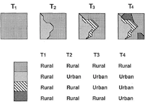
2.2.3 The space-time composite model
Langran (1992) proposed the space-time composite model based on the principle that objects in space at different times can be projected down to a spatial plane and intersect with one another to generate the greatest common units. Each greatest common unit stores the attributes within its boundary over time (Figure 2.4). Changes can be easily
Figure 2.4 The space-time composite model (Langran 1992)
tracked at the greatest common unit level. However, since objects in space at different times might need to be split into smaller units with new IDs, change tracking at the object-level is difficult (e.g., how land parcel A changes between 2000 and 2010). The space-time composite model is could be implemented using either object-oriented approach (i.e., the spatio-temporal information of an object is aggregated and associated with the greatest common unit) or class-oriented approach (i.e., the spatio-temporal information of a greatest common unit is stored in a common attribute table with other greatest common units. Furthermore, this model could be event-based or non-event-based in terms of whether the objects are recorded by event or not.
The space-time composite model was adopted in this study to handle objects without entity identity. Identity is a unique character that distinguishes one object from another; land use data is an example of objects without entity identity. This kind of data does not keep a consistent ID through time for each object so it cannot be recorded at object-level. However, managing spatio-temporal information and tracking changes at the greatest common unit level is simple and straightforward.
Nevertheless, the space-time composite model is cumbersome when dealing with data that is continuously updating. The reason is that the previous greatest common units layer has to be projected and intersected with the latest layer to generate a new greatest common units layer. When handling very large real-world data that update at a high frequency, the space-time composite model is inefficient. However, addressing this issue is beyond the scope of this thesis research.
2.2.4 The amendment model
The key concept in amendment model (Langran 1992) involves the “amendment vectors” that explicitly record spatial changes over time. Any increment is stored based on the status of previous time point (Figure 2.5). The temporal information of this change is stored as attributes of the increment vector. This approach satisfies a variety of spatio-temporal query functions by retrieving and manipulating recorded amendment vectors, such as how a polygon changes at a given time point.
Since the amendment model explicitly records the geometry change of an object over time, the object-oriented approach could benefit its performance by recording the changed geometry in sequence for each object. Also, it could be event-based or non-event-based in terms of whether each object is recorded by event or not.
The amendment model is not suitable for objects without entity identity since the state of each object at each time point must be known in order to calculate the amendment vectors. Furthermore, the amendment model cannot store attribute change that occurs without spatial change since attribute change does not generate amendment vectors. In this thesis research, the proposed space-time GIS model gives attention to this issue so that changes in space, attributes, or both space and attributes can be captured.
2.2.5 The grid model
Langran (1992) proposed a grid model for raster type data. Every cell has a list of historical values in this approach. A new value is added to this list only if change occurs (Figure 2.6). The latest value is always on top, so the current status of the study area can easily be accessed.
The grid model applies the object-oriented approach. The changed value of a pixel is stored with the pixel. As a result, tracking the change of the pixel is efficient. Whether it is event-based or non-event-based depends on how the images are captured (i.e., by event or regularly).
This approach improves on the snapshot model in that unchanged pixels are not recorded so that the data redundancy is greatly reduced. However, the time point at which change occurs for each pixel cannot be determined precisely if data are recorded at regular intervals, unless event-based approach is taken such that data can be recorded when change occurs. Therefore, the grid model is only a somewhat an improved version of the snapshot model. This thesis research proposes a method for spatio-temporal raster data storage in which each pixel is associated with a Space-Time BLOB that precisely records the attribute changes of this pixel over time.
Figure 2.5 The amendment model (Peuquet and Duan 1995)
Figure 2.6 The grid model (Peuquet and Duan 1995)
2.2.6 Event-based spatio-temporal data model (ESTDM)
Peuquet (1994) suggested a TRIAD database framework to integrate time into GIS with an implementation designated as the event-based spatio-temporal data model (ESTDM) (Peuquet and Duan 1995). ESTDM uses concepts from the snapshot (Armstrong 1988) and grid model (Langran 1992). Dual run-length-encoding is applied in ESTDM to maximize storage efficiency. To cover both temporal and spatial domains, ESTDM only records the study area when a specific event happens (e.g., land use change), and keeps track of each new cell value and the pixel location where a specific new value is assigned (Figure 2.7). Therefore, the total amount of storage is determined by the number of events and the number of new values at each event. The event-based concept makes change tracking with ESTDM highly efficient. ESTDM applies the class-oriented approach. Instead of storing new values at the pixel level, the whole area with the same new value is recorded together.
Nevertheless, ESTDM is not applicable to vector-based data; in addition, only one variable can be represented because a raster layer is associated with only one theme. The space-time GIS data model suggested by this thesis research has the potential to
Figure 2.7 Event-based spatio-temporal data model (Peuquet and Duan 1995)
overcome this shortcoming by assigning a separate array for each theme at each pixel. An array records how the value of a theme at this pixel changes over time.
2.2.7 Three-domain model
Yuan’s three-domain (Yuan 1999) representation covers the semantic, temporal, and spatial domains, along with domain links. The semantic domain represents entity classes with unique identifiers throughout the transition, the temporal domain records the time point or time interval instance, and the spatial domain represents spatial configurations of the study area over time. Domain links connect these three domains to convey
meaningful information. Three-domain model uses class-oriented approach since spatio-temporal variation of object is kept using common domain tables and domain links, rather
than being stored separately with object itself. Also, it is event-based. The exact time when a specific change happens is recorded in the temporal domain.
Yuan (1999) used a hypothetical scenario to illustrate how the three-domain model works. However, it would be very complex to maintain the links between different domains for a large amount of data.
2.2.8 Object-oriented model
Worboys (1992) proposed an object-oriented spatio-temporal data model. It consists of two-dimensional spatial objects and a third temporal dimension associated with each object. The basic element in this model is the spatio-temporal atom. This
object-oriented model is also event-based. New spatio-temporal atoms can be stacked on top of existing ones when events occur (Figure 2.8). However, non-spatial changes (i.e.,
attributes changes) cannot be recorded unless they are associated with changes in both space and time. Worboys (1995) later incorporated both event time (i.e., real-world time when something happens) and database time (i.e., time when something is entered into the database) to form a spatio-bitemporal model that records the existence of an object in the real world and database, respectively. He further investigated the difference and relationships of “change”, “event” and “process” associated with the object-oriented modeling constructs (Worboys 1998). According to Worboys, an event is an occurrence or an outcome that has significance, while a process involves a series of activities, events, and interactions so that a goal can be achieved.
The data model proposed by this thesis research is also object-oriented. The identity information of the object that remains consistent over time is used to track object changes. Moreover, it supports recording attribute change without spatial change, since the attribute change can trigger an event as well.
Figure 2.8 Object-oriented model (Yuan 1999)
2.2.9 The extended dynamic GIS model (EDGIS)
Some researchers view the world as being composed of atoms, and space-time
information can be derived using geo-atoms (Goodchild, Yuan et al. 2007; Pultar, Cova et al. 2010). An extended dynamic GIS (EDGIS) model was proposed predicated on this concept. Using EDGIS, the real world is abstracted as themes, features, and space-time points (STP, based on the concept of geo-atoms). An example of how real-world objects are organized using the EDGIS model designates Unita Lakes as a theme is recorded in the Theme table, which is linked with the Feature table (Figure 2.9). Each feature table contains all the features (e.g., Mirror Lake, Red Castle Lake) included in a specific theme. A feature consists of many space-time points, which are recorded in the Space Time Point table, along with the spatial location, temporal and attributes information of this space-time point. In this example, the links between these tables shows how theme, feature and STP are connected. Take Mirror Lake for example, it is a feature of the Unita Lakes theme. Mirror Lake has three STPs, each of which is a record in the Space Time Point table. Since all STPs are managed in the Space Time table, EDGIS uses the class-oriented approach. Moreover, it could be event-based or non-event-based depending on whether STPs are recorded by event or not.
Figure 2.9 The data structure of EDGIS (Pultar, Cova et al. 2010)
The major contribution of EDGIS is that it abstracts the objects in the real-world from both discrete and continuous perspectives, since STPs are more fundamental than objects or fields and represent a key element of either. However, such a revolutionary design requires new data collection method that is able to simultaneously capture discrete and continuous information. In addition, all STPs are stored in a common Space Time Point table. It is sufficient for the small datasets tested in the prototype system. However, large dataset could lead to very long Space Time Point table. This is inefficient when performing spatio-temporal queries.
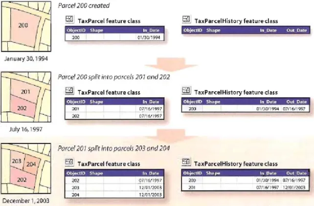
2.2.10 ESRI parcel model
ESRI parcel model is designed for archive parcel transactions. It can also be used for other similar scenarios. Parcel maps in database are continuously updated over time. Real estate transactions, parcel merges and splits occur frequently. This model is able to accurately track the lineage or history of a parcel as it changes by storing changes in additional tables, which allow the historical representation of the updated features. Figure 2.10 illustrate how this parcel model works. The TaxParcel feature class represents the latest state of land use parcels, while the TaxParcelHistory feature class records the historical land use parcels. In_Date is the time when a land use parcel was created, while Out_Date is the time when it was removed. In January 30, 1994, a land use parcel with ID 200 existed. In July 16, 1997, parcel 200 split into parcels 201 and 202. Parcel 200 is recorded in the TaxParcelHistory feature class with an Out_Date
Figure 2.10 ESRI parcel model (Arctur and Zeiler 2004)
07/16/1997. Land use parcel 201 further split into parcels 203 and 204 in December 1, 2003 (Arctur and Zeiler 2004).
ESRI parcel model is class-oriented. All current objects are stored in a feature class which represents the latest state of the study area, while all objects that have been removed are archived in a historical feature class. This model applies the event-based approach. Changes in the database can be made once the real-world transaction occurs. One major shortcoming of ESRI parcel model is that people might need to spend a lot of time in switching between current table and historical table in order to track changes of a certain object. For example, to understand the history of parcel 204, we need to know the In_Date of parcel 204 (12/01/2003) in the current feature class, and then access all
records in historical feature class with Out_Date 12/01/2003. That is parcel 201. After that, we have to access the “current” feature class with the same In_Date as parcel 201(07/16/1997) and use the same procedure to know the history of parcel 201. This process is cumbersome, especially when an object has a long change history.
2.2.11 The TimeObject in the national cooperative highway research program (NCHRP) and other types of time
The previous 10 spatio-temporal data models handle both spatial and temporal domains. The TimeObject and other related topics in this section consider only temporal domain, with a great emphasis on different forms of time.
NCHRP is a program involving problem areas of highway planning, design, construction, operation, and maintenance in the US (Adams, Koncz et al. 2001). In NCHRP 20-27(3), recording and making use of temporal information with spatial object is one of the key topics. The storage of the temporal element of phenomena and its behavior is represented as a time object (Figure 2.11). In NCHRP 20-27(3), time object is the temporal
equivalent of a spatial object, where the time object provides the quantitative description of temporal characteristics of transportation features and events.
The time object in NCHRP 20-27(3) is far more complex than a time stamp (time point). Other forms of time are considered and incorporated, such as time interval consisting of a start time, an end time, and the length between them. Time aggregate is a combination of time objects to form a temporal group. Time aggregate is inherited by four subclasses: time cycle, time break, time stage, and time sequence. A time cycle has its end point connected with its beginning point to represent repeating behaviors, such as a weekly class schedule. A time break consists of the period of time represented by the difference in two disjointed, non-overlapping intervals. A time stage is made of two or more
intervals that can meet, overlap, equal, start, end, or be disjoint. A time sequence consists of two of more time intervals that meet.
This study is inspired by NCHRP 20-27(3) in terms of different forms of time and their relationships. Although temporal structures, such as time cycle, have not been
implemented, they will be incorporated within the proposed space-time GIS data model in the future. Instead of considering time object as separated from spatial object, the data model in this thesis research stores both spatial and temporal information together as Space-Time Elements within the Space-Time BLOB.
Similar temporal forms were proposed by Frank (Frank 1998), who also suggested the time branch (Figure 2.12). Time branches are useful in representing more than one temporal arrangement. For example, a student may have three different plans after 6 pm: studying, exercising, and playing. Consequently, his timeline bifurcates into three time branches after 6 pm. Similarly, time branches can also be used to depict possible historical periods. Incorporating time branches in the proposed data model is discussed in Chapter 5.
As basic temporal components, time points and time intervals can be definite or
indefinite. According to Young and Ziman (Young and Ziman 1971), an indefinite time point or time interval does not have a quantitative measure. We only know its previous and next time points or time interval. This is not uncommon in daily life; for example, one knows that he or she encountered a friend on the way to class but cannot remember
Figure 2.11 Time object in NCHRP 20-27(3) (Adams, Koncz et al. 2001)
Figure 2.12 Different types and structures of time (Frank 1998)
exactly what time it was and how long their conversation lasted. In this case, the encounter may still be incorporated in the time line using the concept of indefinite time
point or time interval. Consideration of indefinite time types is not a feature of this thesis research, but they will be incorporated in a future study due to its importance.
2.3 Spatio-temporal Visualization
Spatio-temporal data, which involves the variation in both spatial and temporal
dimension, are usually far more dynamic and complex than static data. People might be easily confused by the overloaded spatio-temporal data using the traditional visualization approach. On the other hand, a dynamic, interactive visualization approach could benefit research and facilitate understanding of the overall processes, patterns, and trends of spatio-temporal data, as well as the result of the spatio-temporal query.
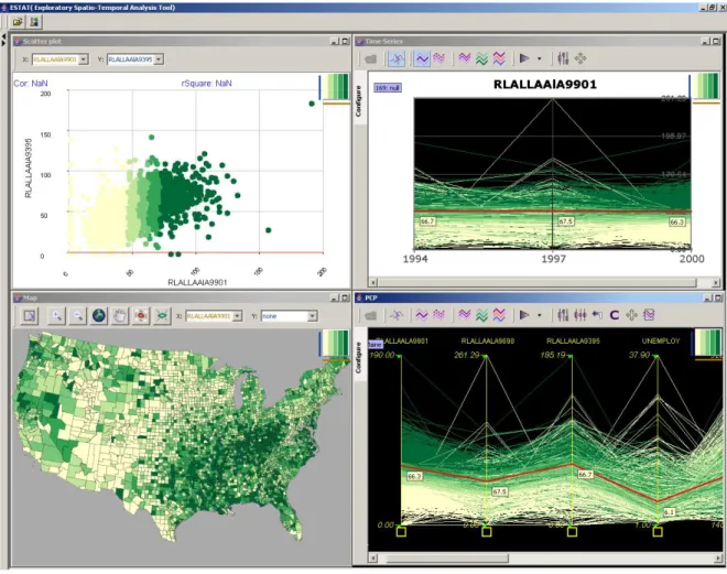
The Exploratory Spatio-Temporal Analysis Toolkit (ESTAT) developed by the
GeoVISTA Center at the Pennsylvania State University (Robinson 2005) supports the visualization of spatio-temporal data using several representation methods (Figure 2.13). A scatterplot can be used to compare the values of two variables, with one plotted against the other, in order to disclose the correlation. By assigning each location in the
scatterplot a color, ESTAT could draw a bivariate map to represent the characteristics of the study region. A parallel coordinate plot (PCP) is designed to display
multi-dimensional data by converting data categories into axes and then drawing lines from one category to another based on the values at each category. A time series graph illustrates the variation of a single variable over time. The most attractive feature of ESTAT is that these four elements are not isolated; instead, they are dynamically linked. If user brushes over a point on the scatterplot, a feature on the map, or a line on the PCP or the time series graph, the corresponding subjects in all other elements are automatically highlighted.
Another challenging topic in geo-visualization is how to represent spatio-temporal multivariate data in a way that people can understand. Guo et al. (2006) applied the self-organizing map (SOM) to transform multivariate data into a two-dimensional space. A two-dimensional color scheme was utilized in conjunction with the SOM to provide meaningful information, upon which it is possible to discern the temporal pattern of multiple variables.
This thesis research focuses on the spatio-temporal data model and spatio-temporal query. However, an interactive representation of the spatio-temporal phenomenon is extremely helpful to suggest ideas about the patterns, trends, and processes of the themes and variables under consideration. This could provide a topic for future research.
Figure 2.13. Four representation methods in ESTAT (Robinson 2005)
2.4 Moving Objects Database
Research on moving objects has been popular in computer science since the late 1990s, especially when location-aware devices began producing a wealth of position data
(Schneider 2009). Challenging moving objects database research topics involve updating continuously changing data in a database efficiently, designing a capable query language (Wolfson, Xu et al. 1998), and discovering hidden patterns in the behavior of multiple objects in large data sets (Laube, Imfeld et al. 2005), among others.
In some cases, only time-dependent locations are of interest, in reference to moving points. Typical examples of this include persons, vehicles, aircrafts, and so on. Such types of moving objects change positions continuously in space over time; hence, Hägerstrand’s time geography concepts (Hägerstrand 1970) could be useful, especially when there is a need to represent the constraints of individuals (Shaw and Yu 2009). The classical space-time prism can be refined or coarsened in terms of the granularities forming threads, trace, and necklaces (Hornsby and Egenhofer 2002). A thread refers to
an ordered sequence of space-time samples that resembles space-time path in time geography. A trace is a coarsened thread with only one start point and one end point. A necklace is a version of space-time prism refined by adding intermediate sample points inside the prism.
In other cases, time-dependent shapes and/or areal extents that grow or shrink through time, namely moving regions, must be handled, examples of which include hurricanes, forest fires, and so forth. In rare cases, time-dependent shapes and/or linear extents (moving lines) that can lengthen or shorten, exhibited by snakes and streams, is of interest. The spatial dynamics of linear and polygon objects are more difficult to
represent in the traditional non-spatial relational database since such objects could not be recorded by a single coordinate pair. Erwig et al. (1999) proposed a new line of research to incorporate moving regions as 3D (2D space and 1D time) entities. These types of entities are abstracted as data types supported by a variety of database management systems (DBMS).
On the other side, moving objects research could be classified as historical moving objects research or predictive moving objects research. The former aims to describe the continuous, dynamic, and time-dependent behavior and location change of spatial objects over time. Thus, spatio-temporal analysis could be performed. The latter intends to predict the temporal evolution of spatial objects at the present time and in the future. The moving objects spatio-temporal model (MOST) is the only model so far to describe future location of the moving objects (Prasad Sistla, Wolfson et al. 1997; Prasad Sistla, Wolfson et al. 1998). Using this model, the predicted position of the moving objects is represented by motion vectors. An update is only needed when the object’s deviation is beyond the specified threshold. A query language, future temporal logic (FTL), which includes both spatial operators (e.g., object INSIDE polygon) and temporal operators (e.g., UNTIL, EVENTUALLY in the future), makes it possible to conduct spatio-temporal queries on this model (Wolfson, Xu et al. 1998).
Both moving objects databases and GIS-based spatio-temporal data models are intended to store the spatial and attribute information of the real-world objects over time. The most significant difference is that the former uses commercial DBMS, while the latter is based on GIS data structure and database, such as Geodatabase. In addition, the GIS-based spatio-temporal data model can take advantage of various spatial analysis functions in GIS platform. Queries that require geometric operation, such as “what is the geometric difference of land parcel A between 2000 and 2010” could be easily conducted with GIS-based spatio-temporal data models. In this thesis research, the proposed data model is GIS-based. As a result, time-dependent locations and shapes are all addressed since points, lines, and polygons are all recorded as Geometry type in GIS packages. This thesis focuses on historical objects. In the future, predictive research of the object could be conducted based on the understanding of the trend and process derived from the historical data.
In conclusion, this chapter explores topics relevant to this study that have been amassed from previous research. Different types of spatio-temporal query were reviewed first, followed by a detailed discussion of spatio-temporal data models which are used to support spatio-temporal query. Spatio-temporal visualization methods which benefit the understanding of the spatio-temporal data and spatio-temporal result were also reviewed in this chapter. Moving object databases study that shares some similarities of spatio-temporal data models are investigated in the final part of this chapter.
CHAPTER 3
AN OBJECT-ORIENTED SPACE-TIME GIS DATA
MODEL
Many efforts have been made to achieve a powerful space-time GIS data model in
previous decades, such as the snapshot model, event-based spatio-temporal data model to support various kinds of spatio-temporal queries. Current space-time GIS models all exhibit some strengths and weaknesses. Some models can handle only vector or raster data, some models have serious data redundancy, while others might be too difficult to implement so as to solve real-world problems. In this chapter, a conceptual model is proposed for processing spatio-temporal datasets and to organize features that evolve over time in the Geodatabase. The specific design in unified modeling language (UML) and the processing flowchart are presented in this chapter. This study focuses on polygon type data; however, this space-time GIS data model is capable of processing data types other than polygons, such as points, polylines, and rasters.
3.1 Relevant Conceptualization of Space and Time
3.1.1 The prevalence of the snapshot model and its limitationTime-stamping is a traditional way to introduce the temporal dimension into GIS. A snapshot records the state of a certain area under study at a specific time point. However, the snapshot model can result in serious data redundancy, especially when the number of snapshot is large. In order to store data covering 50 years in the land use scenario, the analyst might need to deal with about 2,600 layers. It is not uncommon that many parcels do not change for a very long period, while they are still recorded as standalone features in each snapshot layer. Although storing hundreds of thousands of layers is not a problem for Geodatabase, such data structure in itself is inefficient, which may lead to poor performance in spatio-temporal query and analysis. There is no reason to store a feature each time a snapshot is taken of the entire study area when this feature remains exactly the same between two snapshots. In fact, it is more efficient to store a feature only once until a change of either geometry or attribute occurs.
Another reason that the snapshot model is not appropriate for space-time GIS is that it is impossible to keep track of spatio-temporal changes when the snapshot model simply records an object without maintaining its lineage. Even if we have a snapshot at each point in time when a change occurs, the lineage of information is still lost since the snapshot model does not explicitly store which object changes at which point in time. The essential reason of the incapability of snapshot model is that it records data according to a specific division scheme of the timeline, either periodically or in response to an event, rather than focusing on the object itself. This current study refers to that method as a timeline-oriented approach due to the fact that it emphasizes the lapse of time but ignores how things evolve over time. Each object is not considered to be a continuation
of its ancestor’s existence. Consequently, recorded data cannot track how objects change over time.
3.1.2 Object-oriented view of space and time
This study adopts an object-oriented event-based approach that concentrates on variation in objects rather than on the lapse of time as the timeline-oriented snapshot model does. Each object in the real world would be recorded when a significant change applies on it, rather than being recorded again and again with the advancement of the time.
A more efficient way to store continuous and consistent spatio-temporal information is to assign a start time and an end time for the feature during which its geometry and
attributes do not change given the specific spatial and temporal resolutions. The resolution concept is very important: If the resolution becomes finer, there is no guarantee nothing would happen. For example, if we observe a student each hour, we may find out that he was in the classroom at 8:00 am, 9:00 am, and 10:00 am. When the temporal resolution is set to 5 minutes, the result might not be the same. He could go to the room, leave to grab some snacks from the shop, and return during that time. This is similar to the modifiable areal unit problem (MAUP) in spatial analysis research (Dark and Bram 2007). Therefore, when using the approach proposed in this study, it is important to pay particular attention to the temporal resolution.
A start time and an end time, which together constitute a time interval, are the key attributes in tracking spatio-temporal changes. A start time specifies the beginning time point of a new state of the feature, while an end time indicates the time point when it acquires a new status. No record would be created for a feature again during a start time and an end time. However, this approach is not that efficient when people need to retrieve a snapshot at a given time point. The state of each object at the specified time point needs to be generated by figuring out which time interval this time point falls on. It is not easy to access the status of each feature in the snapshot layer method because the intermediate status of a feature is probably unknown. However, retrieving states from time intervals is relatively simple as long as the time interval that the specified time falls in can be found. This is identical to the “during” operation in the temporal topology proposed by Allen (1984).
However, it is not possible to use only time intervals to represent the existence of the object. In many cases we may know an object exists at one time point without having any idea about whether it does thereafter. Thus, both time point and time interval data are necessary. For example, if a pop star was spotted at an airport at 9:00 pm and he took part in an activity from 10:00 pm to 11:00 pm. To record his presence into a database, both time point and time interval data structures are useful.
Since object-oriented space-time GIS design focuses on each object, it can record spatio-temporal changes precisely. Different objects might have different configurations of time