ISSN: 1992-8645 www.jatit.org E-ISSN: 1817-3195
ROAD EXTRACTION IN A VERY HIGH RESOLUTION
IMAGE BASED ON HOUGH TRANSFORMATION AND
LOCAL BINARY PATTERNS
1 ZAAJ IBTISSAM, 2 BRAHIM EL KHALIL CHAOUKI3
, LHOUSSAINE MASMOUDI
1
PhD.Std, LG2I/Laboratory of industrial and computer engineering,National School of Applied Sciences, Ibn Zohr University-Agadir, Morocco
2
Prof, LG2I/Laboratory of industrial and computer engineering. National School of Applied Sciences, Ibn Zohr University-Agadir, Morocco
3
Prof, LETS/Geomat Laboratory, Physics Dept. Faculty of Science, Mohammed V University-Agdal, Morocco
E-mail: [email protected], [email protected],3 [email protected]
ABSTRACT
Recently, many approaches have been presented for automatic urban road extraction. Most of these approaches are based on line detecting algorithms. This paper present a new method of road extraction from high resolution image in urban areas, based on Hough Transformation and Local Binary Patterns. The Hough Transformation method has proven important results to straight line extraction, but it still not sufficient to distinguish between road and others objetcs are similar spectral reflectance (building, parking lots, square and other built-up areas) making road extraction intrinsically difficult. However the Local Binarry Patterns (LBP) seems to be a promising method, it compare the luminance level of a pixel with the levels of its neighbors. This therefore reflects information on regular patterns in the image what is called a texture. The main contribution of this work is using the LBP operator in the road extraction.
We applied our system on a set of satellite imagery, the combination of the LBP operator and Hough transformation provide empirical results illustrating the effectiveness of our approach.
Furthermore, we compared the proposed method with other existing method in the literature.
We conclude that the proposed method can provide an effective means for extracting roads over densely populated urban areas from VHR satellite images.
.
Keywords:Road detection, Local Binary Patterns, Hough transformation, Contour.
1. INTRODUCTION
In recent years, the road extraction from high resolution image has become an increasingly interesting field of research in solving such challenging real-world problem in several areas as military decision, urban planning, emergency management, and vehicle navigation.
The automatic extraction of road networks is an interesting and challenging task. In spite of significant research efforts this problem remains largely open. Many methods are proposed in this field of research.
Research into automated road extraction from
ISSN: 1992-8645 www.jatit.org E-ISSN: 1817-3195
that their method works reliably on challenging urban datasets that are an order of magnitude larger than what was used to evaluate previous approaches. Ünsalan and Sirmacek [6] detected the road networks using a probabilistic framework, consists of three phases: probabilistic road centre detection, road shape extraction, and graph-theory-based road network formation. After graph refinement process, they calculate completeness, correctness. In [7] a proposed algorithm for road networks detection and extraction, based on the combination of perceptual grouping theory (Gabor filtering, tensor voting) and optimized segmentation techniques (global optimization using graph-cuts). A stereoscopic aerial images is using in object-space to extract roads in rural areas, particle filtering and extended Kalman Filtering were used to extract roads from satellite images [8].
This paper presents a new system of road extraction from high resolution image in urban areas. This system is based on the application of the Hough transformation method and Local Binary Patterns descriptor to detect the road located on the image.
The results obtained are not sufficient, street and similar object are shown as a straight lines, we can't differentiate between them. Our proposed idea is to add the LBP operator to hough transformation, for better results. Using LBP operator serves to describe the texture and shape of a digital image. This is done by dividing an image into several small regions from which the features are extracted these features consist of binary patterns that describe the surroundings of pixels in the regions.
• Compared with the work of Örsan Aytekın and all.
Since we will compare our approach with [9] approach, we will briefly describe its : [9] propose en approach to detect buildings and roads. Their approach was based on segmentation, and the regions belonging to buildings and roads were separated using very primitive morphological processing.
The proposed method mainly consists of three steps: First, vegetation and shadow areas are masked and man-made segments are obtained. Next, main roads are detected. Finally, thin and long artefacts are filtered by principal component
analysis (PCA) and small segments are eliminated by morphological operations. The main steps of the method are given in figure 1.
Figure1 : Flow chart of the method [9]
2. PROPOSED APPROACH
The first phase of our proposed system is the preprocessing, Canny edge detection [10] is used to reduce and connect the number of edge in this step. we applied the Hough transformation in the seconde phase.
ISSN: 1992-8645 www.jatit.org E-ISSN: 1817-3195
Figure 2: Overall scheme of the method
2.1 Preprocessing
Canny’s edge detection algorithm [10] is well known as the optimal edge detection method, based on three main principles:
• Low error rate: Meaning a good detection of only existent edges.
• Good localization: The distance between edge pixels detected and real edge pixels have to be minimized.
Cannys edge detection algorithm has been used in this phase to delineate objects in the image. It detects the contours from the derivates method based on the gradient. Due to the resolution of high spatial resolution satellite imagery, edge detectors may not work properly to detect road edges. They can also detect very small noisy terms in the image. These redundant edges may give rise to false alarms and increase the complexity of the problem.
To address this problem we will apply a thinning algorithm based on contours, which is to isolate the local maxima of the derivative image, to reduce the contour points to a curve of a single pixel thick.
Figure3: Canny Edge Detection with Thinning
2.2 Hough Transformation
The Hough Transform (HT) is a robust method developed by Paul Hough [12], to finding straight lines, circles or ellipses.
The HT is employed when gathering the extracted edges into a structure (straight line) is not possible, due to the image criteria or the edge detection performance. It considers a collection of parameterized structure candidates. It then groups the image edges (extracted by Canny edge detector) into an appropriate structure candidate through a voting procedure. Assume detecting a straight line is required.
Each line is defined by the slope parameter α and the y-intercept parameter b, y = αx + b. However, in practice, according the infinite value of the slope parameter for the vertical lines causes computational burden, using Hessen normal form of the line is suggested in [13] as the following, ρ = x cos(θ) + y sin(θ) [12]
where ρ is the distance of the line from origin, and θ is the angle between the x-axis and the line’s normal vector which passes through origin
ISSN: 1992-8645 www.jatit.org E-ISSN: 1817-3195
for each parameter considers a bin in a histogram. Then for every pixel, it tries to find evidences of a straight line and assign it to one of the histogram bins. After that, the bins with higher values are selected as the parameters of the existing straight lines. Finally, depending on the line lengths are not determined, the lines are localized on the image.
2.3 Local Binary Patterns (LBP)
Local Binary Patterns (LBP) is very powreful means of feature description. The LBP operator was originally designed for texture description. Ojiala et al. [14] introduced the Local Binary Pattern operator in 1996 to summarizing local gray-level structure. LBP takes a local neighbourhood around each pixel, thresholds the pixels of the neighbourhood at the value of the central pixel and uses the resulting binary-valued image patch as a local image descriptor.
A local binary pattern is called uniform if the binary pattern contains at most two bitwise transitions from 0 to 1 or vice versa when the bit pattern is considered circular. In the computation of the LBP histogram, the patterns used are uniform so that the histogram has a separate bin for every pattern which is uniform and all non-uniform patterns are assigned to a single bin[15].
It was originally defined for 3×3 neighbourhoods, giving 8 bit codes based on the 8 pixels around the central one. Formally, the LBP operator takes the form LBP.
[15]
where in this case n runs over the 8 neighbours of the central pixel c, ic and in are the gray-level values
at c and n, and s(u) is 1 if u ≥ 0 and 0 otherwise. We can present LBP Algorithm into three steps:
- Step 1: The LBP histogram method, each pixel of an image is labelled with an LBP code.
- Step 2: Then it will first divide the image in several blocks.
- Step 3: For each block the LBP Histogram of an image is calculated and after that all histograms will be combined of that image. Then we will get all histograms into one vector.
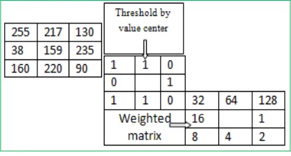
[image:4.612.313.523.120.233.2]The LBP encoding process is illustrated in fig.4.
Figure 4: The basic operator LBP
2.4. Combination of the LBP operator and Hough transformation
After the application of Hough Transformation and Local Binary Patterns on the several High resolution satellite images separately, the obtained results still not significant. we have to determine hypothesis to operate and enhance these results. LBP descriptor output showing the Texture value, So how we will benefit from these results to extract the road network on the high resolution images? And, how to separate the pixels between the road and other similar objects?
Based on the assumption that the road is uniform, means all the pixels which belong to the same road have approximately the same value of the LBP (texture), and these values are different starting from the edges of the road, and applying this approach on the LBP resulting image (fig. 7). We obtained very interesting results.
To validate our approach, and obtained the total detection of roads. We take the line obtained by Hough transformation that we have similar value of LBP (According to our hypothesis these lines corresponds to roads), we combine and compare the resultant image of LBP descriptor and the resultant image of Hough Transformation. Then we applied the subtraction to eliminate the spectral confusion between roads another ground objects (buildings, shadows…)
In the beginning of our simulation, we take two points randomly from the straight line P (x, y, Vp), and Q (x, y , Vq). Where Vp and Vq represent the value of LBPdescriptor.
ISSN: 1992-8645 www.jatit.org E-ISSN: 1817-3195
descriptor should be the same for all the straight line points.
To verify and validate the effectiveness of our approach, we tested the values of LBP descriptor for each points belonging to the window of the tow selected points.
• If the LBP values are uniform (almost the same values of LBP) in at least one perpendicular direction to the detected straight line P (x, y, Vp) = Q (x, y , Vq). So the points are belonging to a road.
• If the uniformity of the points selected was not verified on the right, or on the left of the selected points, P (x, y, Vp) ≠ Q (x, y , Vq), so this straight line not represent a road, it is another similar object.
Which will be eliminated by a filter between the straight lines that contain the same values of LBP descriptor, and the straight lines founded by Hough transformation.
3. EXPERIMENTS ON REAL IMAGES
All experiments are performed on 2.60GHZ Pentium [R] Dual-Core CPU with 0.99 GB of memory, running Microsoft Windows XP Professional Version 2007. For software development, we use Opencv. The evaluation of each method is performed and measured by the quality and the accuracy of road extraction.
The table below presents the result of our approach, applied on the High resolution satellite image.
Table1: Rate of lines road detection of our approach.
Number of lines detected
by Hough Transformation
Number of road
in the image
Number of road detected
by our approach
Detection rate of the road
by our approach 126 40 36 85%
We have 40 real roads on the original image. After the application of Hough Transformation we obtained 126 straight lines, which are higher values due to a very important number of similar objects on the resultant image. However, after applying our approach we found 34 roads, which is an efficient result compared to the number of roads on the original image.
We got a very important value of road detection rate on the high resolution satellite image, which reached 85%. According to the relevant result, our approach is able to extract almost all roads found in the image.
FIGURE 3:INITIAL IMAGE FIGURE 4:CANNY EDGE
FIGURE 5:HOUGH
TRANSFORMATION
FIGURE 6:LOCAL
ISSN: 1992-8645 www.jatit.org E-ISSN: 1817-3195
FIGURE 7:FINAL RESULT FIGURE 8:RESULT OF [9]
The proposed approach has been tested on several real images. An example of the results obtained from the road extraction process is proposed in Fig. 7.
It's clear that it is able to correctly extract all the relevant roads in the image. The results also show the efficiency and the performance of our new approach based on the combination of LBP descriptor and Hough Transformation.
Comared with the result in [9], give acceptable results but fail to obtain an ideal result (figure8), particularly in complex urban areas where road obstacles, e.g. from building, trees and shadows are commonly found, thus affecting the accuracy of road extraction.
4. CONCLUSION
The main contribution of the proposed approach is to address the major issues that have caused all existing extraction approaches to fail, such as: separation of objects, inconsistent road profiles, roadside detection, etc.
Our automatic approach is developed to extracting roads from high resolution aerial and satellite images using characteristic of roads. Three stages are used to implement road extraction: edge detection, Hough Transformation, and LBP descriptor. Simulation results confirm the effectiveness of our work. The combination of Hough Transformation and the LBP operator has given efficient results reached 85% as rate detection. It has a great ability to extract the texture and better recognition accuracy of the lines. Our approach implemented is fast, robust and easy to understand and implement.
The Hough transformation is effective for detecting contours describable by few parameters, which makes the increase of these parameters a major challenge to optimize the calculation time. As a future work, we intend to apply our approach to detect non-linear roads, (circle ...), and look is that it shows the same good performance under these new conditions.
REFRENCES:
[1] M. Tavakoli, A. Rosenfeld, Building and road extraction from aerial photographs, IEEE Trans. Syst. Man Cybern. 12 (1982) 84–91 [2] Xu, G., Zhang, D., & Liu, X. (2009). Road
extraction in high resolution images from Google Earth. Proceedings of International Conference on Information, Communications and Signal Processing (pp. 1-5).
[3] V. Pandit, S. Gupta and K. S. Rajan, “Automatic road network extraction using high resolution multitemporal satellite images”, Proceedings of IEEE IGARSS 2009.
[4] J. Hu, A. Razdan, J. Femiani, P. Wonka and M. Cui, “Fourier shape descriptors of pixel footprints for road extraction from satellite images”, Proceedings of ICIP 2007, pp. 49-52.
[5] Mnih, V., Hinton, G.E., 2010. Learning to detect roads in high-resolution aerial images. In: Computer Vision–ECCV 2010. Springer, 2010, pp. 210–223.
[6] Sirmacek, B., Ünsalan, C., 2011. A probabilistic framework to detect buildings in aerial and satellite images. IEEE Transactions on Geoscience and Remote Sensing, 49(1), pp. 211-221.
[7] Poullis, C., & You, S. (2010). Delineation and geometric modeling of road networks. ISPRS Journal of Photogrammetry and Remote Sensing, 65(2), 165-181.
[8] A. P. Dal Poz, R. A. B. Gallis, J. F. C. da Silva, and E. F. O. Martins, “Objectspace road extraction in rural areas using stereoscopic aerial images,” IEEE Geosci. Remote Sens. Lett., vol. 9, no. 4, pp. 654–658, Jul. 2012. [9] Aytekin, Ö., Erener, A., Ulusoy, İ., Düzgün, Ş.,
2012. Unsupervised building detection in complex urban environments from
ISSN: 1992-8645 www.jatit.org E-ISSN: 1817-3195
[10] P. Bao, L. Zhang, X. Wu, Canny edge detection enhance- ment by scale multiplication, IEEE Trans. Pattern Anal. Mach. Intell. 27 (9) (2005) 14851490.
[11] Y. Rianto, Road network detection from SPOT satellite image using Hough Transformation and Optimal Search, Circuits and Systems,2002, APCCAS 2, 2002, Asia Pacific Conference on, Volume 2, Pages 177-180 vol.2 .
[12] Hough, P.V.C. Method and means for recognizing com- plex patterns. U.S. Patent 3,069,654, Dec. 18, 1962.
[13] Duda, R. O. and P. E. Hart, "Use of the Hough Transformation to Detect Lines and Curves in
Pictures,"Comm. ACM, Vol. 15, pp. 11–15
(January, 1972)
[14] Ojala T, Pietikinen M & Menp T (2002) Multiresolution gray-scale and rotation invariant texture classification with local binary patterns. IEEE Transactions on Pattern Analysis and Machine Intelligence, 24(7):971-987.
[15] F. Tajeripour, E. Kabir, A. Sheikhi, Fabric Defect Detection Using Modified Local Binary Patterns. EURASIP Journal on Advances in Signal Processing, Article ID 783898, 2006.
[16] T.R Mangala. An Effective ANN-Based Classication System for Rural Road Extraction in Satellite Imagery. European Journal of Scientic Research, vol. 47, pages 574585, 2010.