* Corresponding author: B.O Ubechu
International Journal of
Current Multidisciplinary Studies
Available Online at http://www.journalijcms.com Vol. 3, Issue,03, pp.647-663, March, 2017
RESEARCH ARTICLE
LANDSLIDE: CAUSES, EFFECTS AND CONTROL
B.O Ubechu and O.C. Okeke
Department of Geology, Federal University of technology, Owerri Nigeria. Country is Nigeria
A R T I C L E I N F O A B S T R A C T Received 18th December, 2016
Received in revised form 8th January, 2017 Accepted 5th February, 2017
Published online 28th March, 2017
Landslide occurs in various forms and vary in mode, scale and frequency. It also occurs in different environments. The various types of landslide can be differentiated by the kinds of material involved and the mode of movement. The primary cause of landslide is the influence of gravity on weakened material that make up a sloping area of land. Other factors that may cause landslide can be categorized in the following areas: geological factors, morphological factors, physical factors and factors associated with human activities. The impacts of landslide is felt on our natural environment which includes, the topography/morphology of both the sub-aerial and submarine surfaces of the earth, rivers, streams forest and grassland and the habitats of native fauna both on the Earth and in the streams and oceans. The effects of landslide on humans and engineering structures can be lessened by total avoidance of landslide hazard areas or by restricting, prohibiting or imposing safety conditions on hazard – zone activity. Land policies and regulations can also be used to reduce the effects of landslides. Education on past hazard history, consultation with engineering departments and planning unit of the government agencies can help in reducing landslide effects. Prevention of landslide can be achieved by constructing various man made structures on slopes which are vulnerable to landslides. This mitigative measures must be designed to fit the condition of the specific slope under study.
Keywords:
Landslide, geological factors, human activities, pollution and slope stabilization.
INTRODUCTION
A landslide, also known as a landslip, slumps or slope failure, is a geological phenomenon that includes a wide range of ground movements, such as rock-falls, deep failure of slopes and shallow debris flows. In other words, it is the movement of rock, debris or earth down a slope. They result from the failure of the materials which make up the hill slope and are driven by the force of gravity. (Geoscience Australia).
Landslides can occur in offshore, coastal and onshore environments. Although the action of gravity is the primary driving force for a landslide to occur, there are other contributing factors affecting the original slope stability. Typically, pre-conditional factors build up specific sub-surface conditions that make the area/slope prone to failure, whereas the actual landslide often requires a trigger before being released.
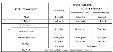
The various types of landslides can be differentiated by the kinds of material involved and the mode of movement. Landslides or slope movements can be classified in many ways. There are many attributes used as criteria for identification and classification including:
Rate of movement: This ranges from very slow creep (millimetres/year) to extremely rapid (metres/second).
Type of material: Landslides are composed of bedrock, unconsolidated sediment and/or organic debris.
Nature of movement: The moving debris can slide, slump, flow or fall.
Although landslides are primarily associated with mountainous regions, they can also occur in areas of generally low relief. In low-relief areas, landslides occur as cut-and-fill failures (roadway and building excavations), river bluff failures, lateral spreading landslides, collapse of mine-waste piles (especially
IJCMS
Copyright © 2017 B.O Ubechu and O.C. Okeke., This is an open access article distributed under the Creative Commons Attribution License, which permits unrestricted use, distribution, and reproduction in any medium, provided the original work is properly cited.
INTERNATIONAL JOURNAL OF CURRENT MULTIDISCIPLINARY RESEARCH STUDIES
coal), and a wide variety of slope failures associated with quarries and open-pit mines. The most common types of landslides are described below.
Types and causes of landslides
Types of landslides
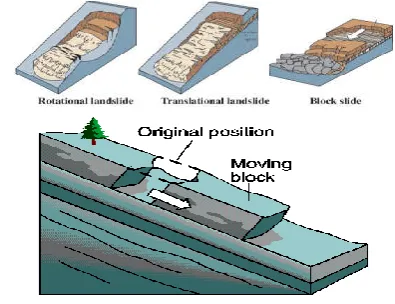
Slides
These are movement parallel to planes of weakness and occasionally parallel to slope. Although many types of mass movements are included in the general term "landslide," the more restrictive use of the term refers only to mass movements, where there is a distinct zone of weakness that separates the slide material from more stable underlying material. The two major types of slides are rotational slides and translational slides. Rotational slide: This is a slide in which the surface of rupture is curved concavely upward and the slide movement is roughly rotational about an axis that is parallel to the ground surface and transverse across the slide (Fig. 1A). Translational slide: In this type of slide, the landslide mass moves along a roughly planar surface with little rotation or backward tilting (Fig. 1B). A block slide is a translational slide in which the moving mass consists of a single unit or a few closely related units that move downslope as a relatively coherent mass (Fig. 1C).
Falls
Falls are abrupt movements of masses of geologic materials, such as rocks and boulders,that become detached from steep slopes or cliffs and falls freely. (Fig.1D).
Separation occurs along discontinuities such as fractures, joints, and bedding planes, and movement occurs by free-fall, bouncing, and rolling. Falls are strongly influenced by gravity, mechanical weathering, and the presence of interstitial water.
Topples
These are rock falls that involve the forward rotation of a detached block above a pivotal point located in the lower part of the detached material under the actions of gravity and forces exerted by adjacent units or by fluids in cracks (Fig. 1E).
Flows
There are five basic categories of flows that differ from one another in fundamental ways.
Debris flow
A debris flow is a form of rapid mass movement in which a combination of loose soil, rock, organic matter, air, and water mobilize as a slurry that flows downslope (Fig. 1F). Debris flows include <50% fines. Debris flows are commonly caused by intense surface-water flow, due to heavy precipitation or rapid snowmelt that erodes and mobilizes loose soil or rock on steep slopes. Debris flows also commonly mobilize from other types of landslides that occur on steep slopes, are nearly saturated, and consist of a large proportion of silt- and sand-sized material. Debris-flow source areas are often associated with steep gullies, and debris-flow deposits are usually indicated by the presence of debris fans at the mouths of gullies. Fires that denude slopes of vegetation intensify the susceptibility of slopes to debris flows.
Debris avalanche
This is a variety of very rapid to extremely rapid debris flow (Fig. 1G) below.
Earthflow
Earthflows have a characteristic "hourglass" shape (Fig. 1H) below. The slope material liquefies and runs out, forming a bowl or depression at the head. The flow itself is elongate and usually occurs in fine-grained materials or clay-bearing rocks on moderate slopes and under saturated conditions. However, dry flows of granular material are also possible.
Figure 1 (A) Rotational Slide, (B) Translational Slide, (C) Block Slide. (Source: http://pubs.usgs.gov/fs/2004/3072).
Figure 1D Fall: material free falls
Mudflow
A mudflow is an earthflow consisting of material that is wet enough to flow rapidly and that contains at least 50 percent sand-, silt-, and clay-sized particles. In some instances, for example in many newspaper reports, mudflows and debris flows are commonly referred to as "mudslides." If slopes are covered by water‐saturated soils or fine‐grained sedimentary deposits, then following an intense rainfall or the melting of large amounts of snow and ice, such material may become liquefied resulting in a mudflow (Fig1K). Of the solid material incorporated into such flows more than 80% are less than silt size (~0.06 mm). Mudflows are generally faster than earthflows and are finer grained than debris flows.
Creep
Creep is the imperceptibly slow, steady, downward movement of slope-forming soil or rock. Movement is caused by shear stress sufficient to produce permanent deformation, but too small to produce shear failure. There are generally three types of creep: (1) seasonal, where movement is within the depth of soil affected by seasonal changes in soil moisture and soil temperature; (2) continuous, where shear stress continuously exceeds the strength of the material; and (3) progressive, where slopes are reaching the point of failure as other types of mass movements. Creep is indicated by curved tree trunks, bent fences or retaining walls, tilted poles or fences, and small soil ripples or ridges (Fig. 1I).
Causes of Landslide
General Treatment
The primary cause of a landslide is the influence of gravity acting on weakened materials that make up a sloping area of land. In general, the factors which influence whether a landslide will occur typically include slope angle, slope stability, climate, weathering, water content, vegetation, overloading, and geology.
How these factors interrelate is important in understanding what causes landslides along with an understanding of the impact humans have on these factors by altering natural processes.
Typically, a number of elements will contribute to a landslide, but often there is one which triggers the movement of material. The difference between these two concepts is subtle but important. The landslide causes are the reasons that a landslide occurred in that location and at that time.
Causes may be considered to be factors that made the slope vulnerable to failure, that predispose the slope to becoming unstable. The trigger is the single event that finally initiated the landslide. Thus, causes combine to make a slope vulnerable to failure, and the trigger finally initiates the movement. Landslides can have many causes but can only have one trigger as shown in the next figure.
(G) (H)
(I) Flow Viscous to Fluid-Like motion Of Debirs
(J) Creep:Gradual movement of slope materials (F) Debris Flow (K) Mudflow
INTERNATIONAL JOURNAL OF CURRENT MULTIDISCIPLINARY RESEARCH STUDIES
Usually, it is relatively easy to determine the trigger after the landslide has occurred (although it is generally very difficult to determine the exact nature of landslide triggers ahead of a movement event). Landslides can be triggered by gradual processes such as weathering, or by external mechanisms. In the majority of cases the main trigger of landslides is heavy or prolonged rainfall.
Factors Influencing Occurrence of Landslides
The main Landslide triggering factors include
i. Rainfall
ii. Earth movement – earthquakes, volcanism, faulting and thunder
iii. Human activities - farming, building, blasting construction, quarrying and other engineering works.
Three distinct physical events occur during a landslide: the initial slope failure, the subsequent transport, and the final deposition of the slide materials.
Landslide causes are listed below, and include geological factors, morphological factors, physical factors and factors associated with human activity.
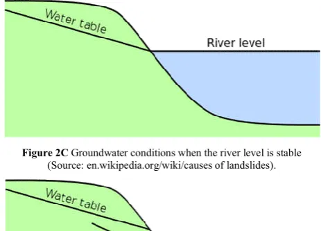
Rainfall/Water
Slope saturation by water is a primary cause of landslides. This effect can occur in the form of intense rainfall, snowmelt, changes in ground-water levels, and water level changes along coastlines, earth dams, and the banks of lakes, reservoirs, canals, and rivers.
Rainfall drives an increase in pore water pressures within the soil. The Figure A illustrates the forces acting on an unstable block on a slope. Movement is driven by shear stress, which is generated by the mass of the block acting under gravity down the slope. Resistance to movement is the result of the normal load. When the slope fills with water, the fluid pressure provides the block with buoyancy, reducing the resistance to movement. In addition, in some cases fluid pressures can act down the slope as a result of groundwater flow to provide a
hydraulic push to the landslide that further decreases the stability.
In some situations, the presence of high levels of fluid may destabilize the slope through other mechanisms, such as:
• Fluidization of debris from earlier events to form debris flows;
• Loss of suction forces in silty materials, leading to generally shallow failures (this may be an important mechanism in residual soils in tropical areas following deforestation);
• Undercutting of the toe of the slope through river erosion.
Snowmelt
In many cold mountain areas, snowmelt can be a key mechanism by which landslide initiation can occur. This can be especially significant when sudden increases in temperature lead to rapid melting of the snow pack. This water can then infiltrate into the ground, which may have impermeable layers below the surface due to still-frozen soil or rock, leading to rapid increases in pore water pressure, and resultant landslide activity. This effect can be especially serious when the warmer weather is accompanied by precipitation, which both adds to the groundwater and accelerates the rate of thawing.
Water-level change
This is probably the most important mechanism by which river bank materials fail, being significant after a flood as the river level is declining (i.e. on the falling limb of the hydrograph) as shown in the following figures.
Table 2 Causative factors of Landslide
Geological Causes Morphological
Causes Human Activities Physical Causes
Weathered Materials e.g. heavy rainfall
Slope angle Excavation Intense rainfall
Sheared materials Uplift Loading Rapid snow melt Jointed or fissured
materials Rebound Draw-down
Prolonged precipitation Adversely
orientated discontinuities
Fluvial erosion
Land use (e.g. construction of roads, houses etc.)
Rapid drawdown
Permeability
contrasts Wave erosion
Water
management Earthquake Material contrasts Glacial erosion Mining Volcanic eruption Rainfall and snow
fall
Erosion of lateral
margins Quarrying Thawing
Earthquakes Subterranean
erosion Vibration Freeze-thaw
Slope loading Water leakage Ground water changes
Vegetation change Deforestation Soil pore water pressure
Erosion Land use pattern Surface runoff/ Soil erosion Pollution Seismic activity
Figure2A Diagram illustrating the resistance to, and causes of, movement in a slope system consisting of an unstable block.
(Source: en.wikipedia.org/wiki/causes_of_landslides).
Figure 2B Diagram illustrating the resistance to, and causes of, movement in a slope system consisting of an unstable block.
Groundwater conditions on the falling limb of the hydrograph. If the fall in river levels is sufficiently rapid then the high water levels in the slope can provide a hydraulic push that destabilizes the slope, sometimes triggering bank collapse It can also be significant in coastal areas when sea level falls after a storm tide, or when the water level of a reservoir or even a natural lake rapidly falls.
Rivers
In some cases, failures are triggered as a result of undercutting of the slope by a river, especially during a flood. This undercutting serves both to increase the gradient of the slope, reducing stability, and to remove toe weighting, which also decreases stability. For example, in Nepal this process is often seen after a glacial lake outburst flood, when toe erosion occurs along the channel. Immediately after the passage of flood waves extensive land-sliding often occurs. This instability can continue to occur for a long time afterwards, especially during subsequent periods of heavy rain and flood events.
Earth Movement
Seismicity
The second major factor in the triggering of landslides is seismicity. Landslides occur during earthquakes as a result of two separate but interconnected processes: seismic shaking and pore water pressure generation. Many mountainous areas that are vulnerable to landslides have also experienced at least moderate rates of earthquake. The occurrence of earthquakes in steep landslide-prone areas greatly increases the likelihood that landslides will occur, due to ground shaking alone or shaking- caused dilation of soil materials, which allows rapid infiltration of water. Worldwide, landslides caused by earthquakes kill people and damage structures.
Liquefaction
The passage of the earthquake waves through a granular material such as a soil can induce a process termed
liquefaction, in which the shaking causes a reduction in the pore space of the material. This densification drives up the pore pressure in the material. In some cases this can change a granular material into what is effectively a liquid, generating 'flow slides' that can be rapid and thus very damaging. Alternatively, the increase in pore pressure can reduce the normal stress in the slope, allowing the activation of translational and rotational failures.
Volcanic activity
Landslides due to volcanic activity are some of the most devastating types. Volcanic lava may melt snow at a rapid rate, causing a deluge of rock, soil, ash, and water that accelerates rapidly on the steep slopes of volcanoes, devastating anything in its path. These volcanic debris flows (also known as lahars) reach great distances, once they leave the flanks of the volcano, and can damage structures in flat areas surrounding the volcanoes. These can occur either in association with the eruption of the volcano itself, or as a result of mobilization of the very weak deposits that are formed as a consequence of volcanic activity. Essentially, there are two main types of volcanic landslide: lavas and debris avalanches.
Environmental Effects and Impacts of Landslide
General Treatment
Landslides impact the following aspects of the natural environment of the earth:
(1) topography/morphology of both the sub-aerial and submarine surfaces of the earth,
(2) rivers, streams, forests and grasslands, and
(3) the habitats of native fauna, both on the Earth’s surface and in its streams and oceans.
Mass movements are part of a natural process that endeavours to equalize differences in elevation in the landscape. Type of soil, the soil’s water content and the inclination of the slope are some of the parameters that govern this process.
The effect of precipitation on groundwater level has a direct effect on the soil's water content and thus the pore pressure. This reduces the strength of the soil and therefore it has a negative effect on stability. Precipitation also impacts the flows in our rivers, and, depending on the river’s geometry, there is a risk of changes regarding erosion, both surface, bank and bottom erosion. And, as a result, the stability of the banks is affected.
Topography/morphology of both the subaerial and submarine surface of the earth
The surface of the Earth, both on the continents and beneath the oceans is continually modified by internal forces and the forces of gravity; both, particularly the latter, produce landslides. The net morphologic effect of landslides is to reduce slopes to angles at which they possess long-term stability. “The processes involved vary enormously from extremely large rapid movements to extremely slow micro-displacement. The result is denudation in the source area, frequent erosion along the transport path, and then deposition, the degree of whose permanence varies widely.” (Small and Clark,1982, p. 27).
Figure 2C Groundwater conditions when the river level is stable (Source: en.wikipedia.org/wiki/causes of landslides).
INTERNATIONAL JOURNAL OF CURRENT MULTIDISCIPLINARY RESEARCH STUDIES
Landslide experts have a reasonable understanding of the volumes of many individual large landslides, and they know that landslides associated with large earthquakes or major volcanic eruptions can denude areas of hundreds to thousands of square kilometers, thus greatly altering the characteristics of mountain slopes and drainage basins. However, much less is known about rates of denudation of slopes that are affected by many small landslides that impact large areas, particularly those caused by heavy rainfall.
Submarine landslides are an important natural slope process by which great masses of sediment move from shallower to deeper regions of the ocean floor. In doing so, they affect major changes in submarine topography. The morphology and mechanics of landslides above and beneath the surface of the sea have many similarities, as well as significant differences. Enormous size is one way that submarine mass movements differ from those above sea level; volumes as large as 20,000 km3 have been reported for submarine landslides (Hampton et al. 1996). The world’s largest submarine landslides (mostly prehistoric) lie off the coasts of South Africa and Norway. However, there are a few very large landslides in the oceans of the Western Hemisphere.
Contributions of Landsliding to Development of Submarine Canyons – Huge submarine canyons incise many of the world’s continental slopes, and the presence of large submarine fans at the mouths of these canyons attests to their importance as major conduits of sediment transport (Hampton et al., 1996), much of which probably occurs as landslides, particularly flows and avalanches. Slope failures may be the dominant process that enlarges and sculpts certain submarine canyons. As an example, Carlson and Karl (1988) have speculated that large submarine canyons along the Beringian margin west of Alaska originated during Pleistocene submarine landslide activity.
Impacts of Landslides on Stream Environments
The main types of landslides that affect streams are debris flows, which may follow the stream channel for great distances (occasionally 100 km or more). Debris flows provide important sediment transport links between hillslopes and alluvial channels, and thus are an important factor in drainage-basin sediment budgets (Benda and Dunne, 1987). In addition, debris flows influence the spatial and temporal distributions of sediment in stream channels, either because they deposit sediment in the channels or because the deposits provide a source for accelerated transport of sediment farther downstream (Benda, 1990).
Swanston (1991) noted the types of stream sediment and channel changes that occur due to introduction of materials by different types of landslides. Slumps and earth flows cause low-level, long-term contributions of sediment and large woody debris to channels; partial channel blockages; local channel constriction below the point of landslide entry; and shifts in channel configuration. Debris avalanches and debris flows cause large, short-term increases in sediment and large woody debris; channel scour; large-scale redistribution of bed-load gravels; damming and constriction of channels; accelerated channel erosion and bank undercutting; and alteration of channel shape by flow obstruction.
As an outstanding example of a long-run out debris flow, remobilization of the already-saturated surface of the June 1980 Mount St. Helens debris avalanche formed a debris/mud flow that continued 95 km beyond the terminus of the debris avalanche (Schuster, 1989). This large flow filled and permanently modified the channels of the Toutle and Cowlitz Rivers and continued into the much larger Columbia River, which was partially blocked by the sediment.
Figure 3A Mount Shasta, California, and the ancestral debris avalanche (foreground) triggered by an eruption some 300,000 yrs B.P.
Figure 3B Destruction of port facilities at Valdez, Alaska, U.S.A., by a submarine landslide triggered by the March 1964 Alaska earthquake
(Coulter and Migliaccio, 1966). (Sketch by David Laneville, U.S. Geological Survey).
Figure 3C Longitudinal profile of the bottom of the Columbia River where sediment resulting from the 18 May 1980 mudflows entered from the Cowlitz River.
Note that most of the sediment was deflected upstream (Schuster, 1989; modified from Bechly, 1980).
Figure 3D Mount St. Helens debris avalanche in valley of North Fork Toutle River, State of Washington, U.S.A.: view east from terminus of avalanche toward
Today, nearly 20 years after the eruption of Mount St. Helens, the Toutle River still is receiving large amounts of sediment that is eroded from the debris avalanche and downstream debris flow. According to the U.S. Geological Survey, sediment levels in the Toutle currently range from 10 times to more than 100 times the amount before the eruption (Bernton, 2000). Sediment levels may remain high for decades, increasing flood risks for downstream communities and threatening efforts to restore salmon and steelhead trout runs that were nearly wiped out by the original debris avalanche and debris flows.
Impacts of Landslides on Forest Cover
Widespread stripping of forest and jungle cover by mass movements has been noted in many parts of the world, but particularly in tropical areas as a result of large-scale, earthquake-induced landslide activity. In September 1935, two shallow earthquakes (M=7.9 and 7.0) in the Torricelli Range, north coast of Papua New Guinea, caused “hillsides to slide away, carrying with them millions of tons of earth and timber, revealing bare rocky ridges completely void of vegetation”
(Marshall, 1937). Approximately 130 km 2
(8 percent of the region affected) was denuded by the landslides (Simonett, 1967; Garwood et al., 1979). On the south slope of the Torricelli Range, Montgomery and Eve (1935, p. 14) reported: “Soil and sub-soil with their covering of tropical jungle had disappeared from 60% of the slopes, baring the underlying bedrock.” In November 1970, a M=7.9 earthquake triggered landslides along the north coast of Papua New Guinea removed shallow soils and tropical forest vegetation from steep slopes in the Adelbert Range (Pain and Bowler, 1973). Vegetation was stripped from about 25 percent of the slope surfaces in the
240-km 2
area that was affected by landsliding. Similarly, in 1976 two shallow earthquakes (M=6.7 and 7.0) struck the sparsely populated, jungle-covered, southeast coast of Panama, causing huge areas of landsliding. Garwood et al. (1979) estimated that the slides removed approximately 54 km2of jungle cover (12 percent of the affected region of 450 km2).
In a detailed study of revegetation patterns of landslide-destroyed forests by Smith et al. (1986), found that forest cover returned to landslide areas more slowly than to logged areas; forest productivity of landslide areas was reduced by about 70 percent when compared to similarly-aged logged areas.
Impacts of Landslides on Wildlife
Although most kinds of wildlife are able to retreat fast enough to prevent injury from all but the fastest-moving landslides, all wild creatures are subject to landslide-caused habitat damage and destruction. Fish are probably most affected because they are dependent on stream access and water quality for their livelihood, both of which are often affected by landslides. Thus, although landslides, on one hand, create a hostile stream environment for fish, on the other they may provide long-term stream refuges that aid survival. From the hostile environment point of view, Swanston (1991) noted that storm flows and landslides are the dominant random events that cause physical habitat deterioration in streams.
Especially susceptible to stream environment changes are anadromous fish (such as salmon), which live in the oceans but return to fresh-water streams to spawn. Their passages can be blocked by landslide dams or their spawning beds can be damaged or destroyed directly by landslide deposits or by sediment washed into the streams by landslides.
Stream sediment, from landslides or other sources, contributes to the deterioration of fish habitat and affects downstream water quality (Sidle et al., 1985, p. 9). When sediment is suspended: (1) it blocks the transmission of light, thus reducing algae production, and (2) it damages the gill membranes of the fish, causing death where concentrations are high and exposure is prolonged (Phillips, 1971). When sediment settles onto gravel beds, it is harmful in the following ways: (1) it fills the gravel interstices, reducing the supply of dissolved oxygen to the fish eggs; (2) it forms a barrier to fry emergence; and (3) survival after fry emergence is impaired because of loss of escape cover and reduction of aquatic organisms that are food for the fry. Excess sediment can also damage rearing habitat, areas where young fish feed and grow, by creating unfavorable conditions for growth of aquatic insects (Meehan, 1974).
Major debris flows, most certainly killed a large percentage of the fish populations in streams. However, within a few years stream regimens would have improved, and at least some species would have returned to the formerly barren stretches of river.
As an example of stream-habitat deterioration, in their study of irrigation-induced landslides in south-central Washington State, U.S.A., Schuster et al. (1989) noted severe landslide-caused siltation of spawning beds for anadromous fish in the last free-flowing stretch of the Columbia River in the United States.
Although wild animals and birds are usually less likely than fish to be directly affected by landslide activity, the senior author noted a case of destruction of a bird habitat due to landslide activity during his study of irrigation-induced landslides in fluvial-lacustrine sediments along the Columbia River in south-central Washington State. In the spring of 1981, hundreds of cave nests had been excavated by cliff swallows into the 25-m-high silt/sand head scarp of a major slide.
Figure 3E Destruction of vegetative cover on valley walls of the upper Río San Vicente, a tributary of the Río Paez, southwestern Colombia, by
INTERNATIONAL JOURNAL OF CURRENT MULTIDISCIPLINARY RESEARCH STUDIES
During the visit, the swallows’ eggs were in the process of hatching. A few days later, the slide reactivated and the scarp retrogressed catastrophically. Undoubtedly, nearly all of the newly-hatched birds and some of their parents were killed by the sudden habitat destruction.
Although there is general agreement that landslides result in short-term deterioration of mountain-stream fish habitat, there is a growing feeling among ecologists that landslides may increase the quality of fish habitat in the long-term by breaking up stream flow. For example, landslides may deliver large boulders to a stream, thus forming downstream pools that provide quality habitat (Sedell et al, 1990). As noted by Reeves et al. (1995, p. 717): “When intense rainstorms saturate soils during periods of low root strength, concentrated landsliding
into channels and debris flows may result. Such naturally occurring disturbances in stream channels can have both immediate impacts on and long-term implications for anadromous salmonids. Immediate impacts include direct mortality, habitat destruction, elimination to access to spawning and rearing sites, and temporary reduction or elimination of food resources.
Longer-term effects may be positive, however; landslides and debris flows introduce essential habitat elements, such as large wood and sediment, into channels and affect storage of these materials. The configuration of channel networks, the delivery, storage, and transport of sediment and wood, and the decomposition of woody debris interact to create, maintain, and distribute fish habitat over the long term.” Montgomery et al. (2003) generally agree with the surmise that landslides can improve fish habitat in streams over the long term.
Spread Environmental Pollutants By Landslides
Mass movements of soil could act as an effective route of dispersal for pollutants from the soil to surface waters. Landslides and slips, when they occur along coastal areas, lakes and river can cause environmental pollutants from contaminated ground to be dispersed.
Both contaminated areas and areas at risk of mass movements are found to a large extent along our major surface water systems. Where these areas overlap, there is a risk of increased dispersion of contaminants through slides and slips. Through mass movements, contaminated soil can be moved up to the ground surface, which increases the risk of exposure.
Large quantities of contaminated soil can be moved out into the surface water. The surges formed can carry along material for some kilometers upstream and ten of kilometers downstream, over a time scale from minutes to hours. These surges can also cause further mobilization of material, sediment as well as contaminants, when they reach and erode surrounding areas of river bank.
Should the mass movement result in damming up, the flooding caused can give rise to leaching and mobilization of contaminants in areas upstream.
Loss of Soil Resources By Landslides
In major landslides, all of the soil/colluvium down to bedrock is carried downslope, taking all of the trees and other vegetation with it. Because no soil is left for new plants to grow on, the bare tracks of landslides can remain visible for hundreds of years. There have been a few attempts to quantify losses of soil resources due to landslide activity. Noteworthy is the study by Wright and Mella (1963) of the effects of the1960 earthquake-induced landslides in south-central Chile on the soil resources of the area. They noted the complete destruction of: “steep land soils that plunged, in the form of landslides, debris avalanches, and mudflows, directly into the depths of various lakes. The total area involved is probably in the neighborhood of 20,000 hectares. Practically none of this land was well adapted to agriculture, although about 10% (2,000 hectares) of the lower slopes had been partly cleared by farmers living along the lake margin, in an effort to provide additional grazing for the livestock on their small farms.” (Wright and Mella, 1963, p. 1395). Also noted was the “partial destruction” of some 15,000
Figure 3F Irrigation-caused landslides have badly damaged salmonid spawning grounds in the last free-flowing stretch of the Columbia River,
Washington State, U.S.A.
Figure 3G April 1981 aerial oblique view of the 12-million-m3,
irrigation-induced Savage Island landslide on the Columbia River, south-central Washington State, U.S.A. In the spring of 1981, hundreds of baby
cliff swallows were killed when their nests in the 25-m-high main scarp were destroyed because of catastrophic headward recession of the
ha of steep-land soils that were “transported” from hillslopes to valley floors by mudflows and debris flows where they formed a: “rumpled heap of soil and forest debris of far lower agricultural value, for the moment, than the original valley soils that they overwhelmed. In some places the debris is spread out more evenly and in time may rapidly be developed into useful farmland. Some of the area damaged by this type of transportation was of little real agricultural value, but of the total area involved, some 10% (or 1,500 hectares) represents useful agricultural land now buried under debris.” (Wright and Mella,1963, p. 1397).
It should be noted that some of the soil lost from hill slopes because of landslide activity with the passage of time may be reconstituted as usable agricultural soil in the valleys below. This is especially true in the case of debris-flow deposits in the form of debris fans or terraces, which with time may provide excellent agricultural conditions, either for pastureland or for crop production.
Retreat of Coastal Cliff Due to Landslides
With wave action serving as the primary trigger, landslide activity is the main process in the retreat of coastal cliffs. The most common landslide types in the failure of coastal cliffs are rock-and-soil fall, slides, and avalanches. However; topples and flows also occur occasionally. Many examples of coastal cliff retreat have been documented in the literature. The amount of cliff retreat is based primarily on the type of geologic material from which the cliff is composed and the strength of wave action.
Landslide Stabilization and Mitigation
General Treatment
Vulnerability to landslide hazards is a function of location, type of human activity, use, and frequency of landslide events. The effects of landslides on people and structures can be lessened by total avoidance of landslide hazard areas or by restricting, prohibiting, or imposing conditions on hazard-zone activity. Local governments can reduce landslide effects through land-use policies and regulations. Individuals can reduce their exposure to hazards by educating themselves on the past hazard history of a site and by making inquiries to planning and engineering departments of local governments. They can also obtain the professional services of an engineering geologist, a geotechnical engineer, or a civil engineer, who can properly evaluate the hazard potential of a site, built or unbuilt.
The hazard from landslides can be reduced by avoiding construction on steep slopes and existing landslides, or by stabilizing the slopes. Stability increases when ground water is prevented from rising in the landslide mass by (1) covering the landslide with an impermeable membrane, (2) directing surface water away from the landslide, (3) draining ground water away from the landslide, and (4) minimizing surface irrigation. Slope stability is also increased when a retaining structure and/ or the weight of a soil/rock berm are placed at the toe of the landslide or when mass is removed from the top of the slope.
Landslide mitigation also refers to lessening the effect of landslides by constructing various man made projects on slopes which are vulnerable to landslides. The stability of any slope
will be improved if certain actions are carried out. To be effective, first one must identify the most important controlling process that is affecting the stability of the slope; second, one must determine the appropriate technique to be sufficiently applied to reduce the influence of that process.
The mitigative prescription must be designed to fit the condition of the specific slope under study. For example, installation of drainage pipes into a slope that has very little ground water is pointless.
The selection of appropriate mitigation measures should be based on an assessment of risk, uncertainty, possible consequences, constructability, environmental impacts and costs. A final mitigation approach usually consists of a creative combination of several methods.
Within a risk-based approach to landslide management, the classification of mitigation measures is usefully related to the terms of the “risk equation”
R = (E)·(H·V) ……….(1)
• Measures to reduce HAZARD
• Measures to reduce VULNERABILITY to landslides
• Measures to reduce the ELEMENTS at risk
• Measure to SHARE RESIDUAL RISK
Slope stabilization measures operate by increasing the resisting forces and/or by decreasing the driving forces. They can be subdivided in relation to the physical process involved:
• Surface protection and erosion control
• Modifying the geometry and/or mass distribution • Modifying the surface water regime; surface drainage • Modifying the groundwater regime; deep drainage • Modifying the mechanical characteristics of the
unstable mass
• Transferring loads to more competent strata
Retaining structures are described as an additional class of hazard mitigation measures, even though they do not address a specific physical process
Slope stabilization efforts take place during construction or when stability problems develop unexpectedly following construction. Most slope engineering techniques require a detailed analysis of soil properties and a sound knowledge of the underlying soil and rock mechanics.
In so far as landslides are typically the result of several concurrent factors, it is often necessary to implement different stabilization measures. Appropriate measures will be selected taking into account:
• factors which determine the Hazard: stratigraphy, mechanical characteristics
• of materials, surface and underground water regime, morphology, processes;
• factors which affect the nature and quantification of Risk for a given hazard,
• such as the presence, vulnerability and value of elements at risk;
INTERNATIONAL JOURNAL OF CURRENT MULTIDISCIPLINARY RESEARCH STUDIES
phase and rate of movement, accessibility, environmental constraints, preexisting structures and infrastructure, capital and operating cost, maintenance
Therefore, slope stabilization methods in rock or in earth, can be collocated into three types of measure:
• Geometric methods, in which the geometry of the hillside is changed (in general the slope);
• Hydrogeological methods, in which an attempt is made to lower the groundwater level or to reduce the water content of the material;
• Chemical and mechanical methods, in which attempts
are made to increase the shear strength of the unstable mass or to introduce active external forces (e.g. anchors, rock or ground nailing) or passive (e.g. structural wells, piles or reinforced ground) to contrast the destabilizing forces.
Surface Protection and Erosion Control
Slope Stabilization Using Vegetation
Seeding with grasses and legumes reduces surface erosion, which can under certain conditions lead to landslides. Planting with shrubs adds vegetative cover and stronger root systems, which in turn will enhance slope stability. If not controlled, surface erosion and small, shallow slope failures can lead to larger problems that cannot be controlled.
Planning is required for the successful implementation of a re-vegetation program. Before undertaking seeding, a person with local experience should be consulted for advice. Local knowledge based on successes and failures of projects is invaluable. Seed application should begin immediately following a disturbance, at a minimum of approximately 6 weeks before periods of drought or damaging frost.
A slope made as stable as possible before seeding will be of benefit in making the slope resistant to future erosion and failure. Controlling surface-water drainage, removing cut-bank overhangs, reducing slope angles, and benching all should be done before seeding begins.
There are two basic types of seeding: dry seeding and hydraulic, also known as hydroseeding:
Types of seeds
A combination of two to five species is the normal grass-legume mix used for erosion control. Suitability of seeds depends on soil type, climatic conditions, species compatibility, and species replacement. Local conditions will vary, and no universal type of grasses or legumes can be recommended. The types of vegetation can vary from locality to locality, and it is best to get advice from locals who are familiar with local growing conditions.
Mulching
Mulch is a nonliving material spread over the soil surface to provide protection from surface erosion by rain and retention of soil moisture. Various types of mulches will work—straw, grass fibers, wood fibers, seaweed, and paper products.
Biotechnical Slope Protection
This type of slope protection is used to reduce the environmental consequences of landslide-mitigation measures.
When used for landslide remediation or mitigation,
conventional earth-retaining structures made of steel or concrete usually are not visually pleasing or environmentally friendly. These traditional “hard” remedial measures are increasingly being supplanted by vegetated composite soil/structure bodies that are environmentally more friendly. This process has come to be known as biotechnical slope protection. Common biotechnical systems include geonets anchored by soil nails that hold in place soil seeded with grass and geocells with seeded soils in the interstices.
Research has been done on using plants to stabilize soil to prevent excessive erosion and also to mitigate the effect of landslides. One of the most promising types of plants is Vetiver,
Figure 4A Some influences of vegetation on the soil. (Coppin & Richards, 1990)
Figure 4B Change in erosion rate due to increasing vegetative cover (soil loss ratio: soil losses measured on cropped area / corresponding loss from clean-tilled area, canopy cover: the percentage of planted area). (source:
Coppin and Richards, 1990)
a type of grass that works very well in many different environ-ments, to stabilize slopes against erosion.
Biotechnical slope protection consists of two elements:
biotechnical stabilization and soil bioengineering stabilization, both of which entail the use of live materials—specifically, biotechnical vegetation stabilization uses mechanical elements (structures) in combination with biological elements (plants) to prevent and arrest slope failures and erosion. Mechanical and biological elements must function together in a complementary manner. Soil bioengineering stabilization, on the other hand, can be regarded as a specialized subset of biotechnical stabilization in which live plant parts, that is, roots, stems, and branches, serve as the main structural/mechanical elements in the slope protection system. Biotechnical slope-protection systems blend into the landscape. They emphasize the use of natural, locally available materials, such as soil, rock, timber, and vegetation, in contrast to manufactured materials such as steel and concrete. The structural or mechanical components do not visually intrude upon the environment as much as
conventional earth-retaining structures. Examples of
biotechnical vegetation structures, which commonly
incorporate vegetation into the structure itself, include log and timber cribs, gabion and rock-breast walls, welded wire walls, and reinforced earth. Internal, tensile reinforcements using the principles of bioengineering permit construction of over-steepened fill slopes to as much as 70º.
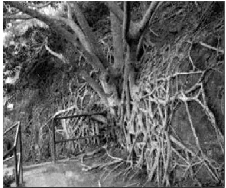
Nature’s concept of soil reinforcement shown to good effect in the root network of a banyan tree, stabilizing a near-vertical cut
Excavation
Figures below provide a cross-sectional view, in schematic form, of general principles for slope excavation, showing the effects and consequences of where on a slope the excavation takes place.
Removal of soil from the head of a slide
This method reduces the driving force and thereby improves stability. This method is suitable only for cuts into deep soil where rotational landslides may occur. It is ineffective on translational failures on long, uniform or planar slopes or on flow-type landslides.
Total or partial removal of the actually or potentially unstable mass, toe weighting and more generally modification to the geometry and/or mass distribution of slopes are widely used techniques to mitigate the hazard, and to some extent the consequences, of landsliding.
Possible modifications to the geometry of the slope include:
Figure 4D A Vetiver grass system is being used in the Democratic Republic of the Congo for gully control in urban areas and for highway
stabilization. These gullies are a major problem in this area and other West African countries (top); the same slope now has improved drainage, and the slope has been planted in Vetiver grass (middle); this
planting of Vetiver grass is about 3 months old.
Figure 4E Stabilization of a slope by the root system of a banyan tree, Hawaï (source: Google Books Result,
INTERNATIONAL JOURNAL OF CURRENT MULTIDISCIPLINARY RESEARCH STUDIES
• Total removal by mass excavation of the actually or potentially unstable soil and/or rock mass; a special case is representated by trimming and scaling to remove individual hoverhangs, bulges or loose blocks which pose a rockfall hazard on otherwise stable rock slopes.
• Partial removal by mass excavation of soil and/or rock from the driving area (or more in general, regrading or flattening slope angle) to reduce the driving forces, thereby improving overall slope stability.
• Where necessary, for example to preserve the integrity of infrastructure, the excavated mass may be substituted, in whole or in part, by lightweight fill using naturally occurring (geological) materials such as pumice or shells, manufactured materials, such as expanded clay, polystyrene slabs, cellular concrete, and waste materials or by-products, such as soil mixed with shredded tyres (‘pneusol’), pulverized fly ash, slag, woodchips or logging slash.
Lightweight fill is also used to minimize the extent and cost of other mitigation measures by minimizing the adverse effect of construction, for example where alignment constraints may dictate that fills for a new highway be placed in a potentially destabilizing position across an actual or potential landslide.
• Addition of material to the toe or resisting area (or more in general, buttressing, counterweight fills and toe berms), which operates by increasing the resisting forces, thereby improving overall slope stability, by providing sufficient dead weight or restraint near the toe of the unstable slope.
Reducing the height of the slope
Reducing the height of a cut bank reduces the driving force on the failure plane by reducing the weight of the soil mass and commonly involves the creation of an access road above the main road and the forming of a lower slope by excavation.
Figure 4F Illustration of the differences in stability resulting in excavation at the head and toe surfaces of a slope. (htpp://pubs usgs.gov>pdf>sections).
Also, it is possible to excavate deeply and lower the main road surface if the right-of-way crosses the upper part of a landslide. This method is only moderately efficient in increasing stability, and a complete solution may involve additional modification of the land. According to Chatwin, it usually increases the Factor of Safety by only 10 or 15 percent. (“Factor of Safety” in its simple definition is the ratio of the maximum strength of a piece of material or a part to the probable maximum load to be applied to it.)
Backfilling with lightweight material
A technique related to height reduction is to excavate the upper soil and replace it with a lightweight backfill material such as woodchips or logging slash. Then, covered with a thin layer of coarse aggregate, the backfilled material can form a foundation for limited-use traffic.
Drainage Techniques
Ground water probably is the most important single contributor to landslide initiation. Not surprisingly, therefore, adequate drainage of water is the most important element of a slope stabilization scheme, for both existing and potential landslides. Drainage is effective because it increases the stability of the
soil and reduces the weight of the sliding mass. Drainage can be either surface or subsurface. Surface drainage measures require minimal design and costs and have substantial stability benefits. They are recommended on any potential or existing slide.
The two objectives of surface drainage are to prevent erosion of the face, reducing the potential for surface slumping, and to prevent infiltration of water into the soil, thereby reducing ground-water pressures. Subsurface drainage also is effective but can be relatively expensive.
]
It is therefore essential that ground water be identified as a cause of the slide before subsurface methods are used. The various methods of drainage include the following:
Drainpipes
Horizontal drainpipe is a widely used device for landslide prevention in highway construction (Fig. 4J). It is most effective when installed during initial excavation. Because of the long lag times to lower ground-water tables, the drains are effective only if the pipe is carefully installed, the failure surface is intersected, and the pipe actually drains the soil. As most slopes have varying soil and hydraulic and geometric conditions, drainage systems must be individually designed. After drilling has been carried out to the desired depth and the casing installed, the latter is cleared of soil, and sections of slotted PVC drainpipe are covered with filter cloth, then pushed into the casing and coupled together. The casing is then withdrawn and screen is installed over the end of the drain. Drain holes must be thoroughly cleaned of drill cuttings and mud. Uncleaned holes may be only 25 percent effective.
In clay soils, the full change in ground-water tables can take up to 5 years, with 50 percent of the improvement taking place in the first year. Once water tables are lowered in clay soils, the change is fairly permanent; however, seasonal fluctuations can occur: rainfall will not alter the ground-water level in the slope provided the drains do not clog. In sandy soils, the ground-water table will lower within a few months but will also fluctuate with rainfall.
Figure 4H Illustration of the importance of water in the stability of a slope. ((htpp://pubs usgs.gov>pdf>sections).
INTERNATIONAL JOURNAL OF CURRENT MULTIDISCIPLINARY RESEARCH STUDIES Retaining Walls
For all types of retaining walls, adequate drainage through the structure is essential because very high ground-water pressure can build up behind any retaining wall, leading to its failure. Drainage can be provided simply with a coarse backfill and foundation material.
Gabion walls
Gabions are wire mesh, boxlike containers filled with cobble-sized rock that are 10 to 20 centimeters (4 to 8 inches) size. A gabion retaining wall can also be constructed from stacked gabions. Gabion walls usually are inexpensive and are simple and quick to construct. Due to their flexibility, they can withstand foundation movement, and they do not require elaborate foundation preparation. Because of their coarse fill, they are very permeable and thus provide excellent drainage.
Reinforced earth wall
Reinforced Earth is a patented system for constructing fills at very steep to vertical angles without the use of supporting structures at the face of the fill. The system uses horizontal layers of flexible metal strips within the fill to form a composite earth-metal system with high strength.
Case Histories of Some Landslides Occurrences In Nigeria
Case History 1: The study of Landslide using Rock Aggregates
Landslides in Nigeria are geologically controlled. In the work titled “The Geotechnical Characteristics of Landslide on the Sedimentary and Metamorphic Terrain South-East Nigeria West Africa”. The landslides on the sedimentary terrain were mainly shallow, low-volume movements, material slumps and short runout slides some of which activated on slopes that followed the dip of strata, along wavy shear surfaces controlled by impermeable bedding planes. Runoff-triggered movements caused by erosion of channel bed and banks and failures caused by sediment bulking of runoff with material eroded from headwater slopes are also common on the sedimentary terrain. In comparison, the landslides on the metamorphic terrain were complex translational and rotational movements and mudslides on steep slopes sometimes involving a combination of slide and flow with curved headscarps and slickensided shear surfaces. The looseness of slope materials and their relatively low strength parameters account for the dominance of landslides on the sedimentary zone.
The results showed that landslide in Enugu area, being a sedimentary environment are mainly slumps and short runout debris of limited volume despite their low elevation and slope angle. In this region, the slow to rapid unsaturated movements usually initiate within the loose friable sandy body of high permeability or on clay/shale interlayer. Landslides occur when soil thickness accumulating at sufficient depth are saturated by rain infiltration.
From his findings, the sedimentary area are more susceptible to landsliding than the areas within the metamorphic locality. This is as a result of human activities like deforestation, climatic conditions and erosion in the study area. These accelerate weathering and influence landslide occurrence. In the metamorphic terrain, the sliding material is dominated by finer fraction (71.5%) of micaceous silty sand and coarser fraction of gravel to boulder size. This material is poorly-sorted matrix colluviums supported by about 43% clay matrix. Saturation of the residual soil, weak bedrock and high slope angle are the primary factors in the slide-trigger in this area. Heavy rains during the peak season induced mass movements on the mountainous metamorphic terrain. The characteristics clay matrix probably contributed to the rapid movement and longer travel distance on this terrain. (Igwe, 2015).
Case History 2: The Study of Landslide Susceptibility Using Remote Sensing Images
Land slide occur in different parts of Southeastern Nigeria due to widespread impact of golly erosion resulting from subsequent flooding. In this area, landslide occurs mostly as earth movement, rock and debris flows on slopes previously weakened by floodwater.
Figure 4J Schematic of drainpipes. (htpp://pubs usgs.gov>pdf>sections)
The purpose of the study is to map the landslide potential areas of Anambra State in Southeastern Nigeria. The study is to classified the area into landslide potentials according to their degree of susceptibility. For this five classes were identified;
1.Least susceptible Area 2.Less
3.Average 4.More
5.Most susceptible Areas.
Remotely Sensed Images combined with field observation were used in the study to map potential areas of landslides in South-Central parts of Nigeria. From the result, most susceptible areas to landslide are where the terrain undulation is high. In these areas, the impact of rainfall induced flood water is high and slope failures are very predominant. Here , there are occurrence of deep and wide gullies as more and more sloppy grounds cave in after being weakened by the impact of rainfall.
Areas that are area of average, less or least susceptible are found mainly in the low lying grounds.
Table 3 shows the different areas of susceptibility and the percentage of the total areas occupied. The table revealed that most susceptible areas occupy 11.98% of the area studied or 9827.088 Hectares, while more susceptible areas are found in 29.58% of the study area. The average susceptible areas occupy a total of 25.74% of the study area or about 21104.772 Hectares.
The less and least susceptible areas occupy 31.43% of about 25771.475 Hectares.
The implication of these findings is that the areas is densely populated with extensive network of roads and dense concentration of residential houses. Therefore slope failure and landslides causes extensive damage with each rainy season. This sometimes leads of loss of life. Also, medium scaled remotely sensed data can be used to analyse areas susceptible to landslide in the southeastern part of Nigeria as high resolution remote sensing data are difficult to access. (Igbokwe et al, 2008).
CONCLUSION
Landslides are a significant component of many major natural disasters and are responsible for greater losses than is generally recognized.
The term Landslide describes many types of downhill earth movement, ranging from rapidly moving catastrophic rock avalanches and debris flows in mountainous regions to more slowly moving earth slides and other ground failures.
Landslides are a significant component of many major natural and are responsible for greater than is generally recognized.
The various types of landslide can be differentiated by the kinds of material involved and the mode of movement Causative factors of landslides include Geology, Morphology and human causes.
The main triggers are rainfall, earth movement, and human activity.
Landslide has been on the increase in the recent past. Landslide tend to burry all that is on their way, resulting in loss of life and property.
The effects of landslide on people and structure can be lessened by total avoidance of Landslide hazard areas, avoiding construction on steep slopes and existing landslides or by stabilizing the slopes.
References
Åkesson, M (2010). Mass movements as contamination carriers in surface water systems – Swedish experiences and risks, Examensarbete i geologi vid Lunds Universitet, Kvartärgeologi, no. 253, Institutionen för geo- och ekosystemvetenskaper, Enheten för geologi, Lunds universitet.
Benda, L. (1990) . The influence of debris flows on channels and valley floors in the Oregon Coast Range, U.S.A.,
Earth Surface Processes and Landforms, Vol. 15, pp. 457-466.
Benda, L. and Dunne, T. (1987). Sediment routing by debris flows. In R.L. Beschta, T. Blinn, G.E. Grant, G.G. Ice and F.J. Swanson, eds., Erosion and sedimentation in the Pacific Rim, IAHS Publ. 165, pp. 213-223.
Bernton, H. (2000). Mount St. Helens’ debris still sullies Toutle River, The Oregonian, Portland, Oregon, 16 January, pp. D1.
Caine, N., (1980). The rainfall intensity-duration control of shallow landslides and debris flows. Geografiska Annaler, 62A, pp. 23-27.
Carlson, P.R. and Karl, H.A. (1988). Development of large submarine canyons in the Bering Sea, indicated by morphologic, seismic, and sedimentologic characteristics,
Geol. Soc. Am. Bull., Vol. 100, pp. 1594-1615.
Chatwin, S.C., Howes, D.E., Schwah, J.W., and Swanston, D.N., (1991), A guide for management of Landslide-Prone terrain in the Pacific Northwest, Britisa Columba Ministry of Forest, Land Management Handbook, 18, 212pp.
Chatwin, S.C., Howes, D.E., Schwah, J.W., and Swanston, D.N., (1991), athe Landslide Handbook – A guide to understanding Landslides. Appendix C pdf. Introduction to Landslide Stabilization and Mitigation. Retrieved from http://pubs.usgs.gov>pdf>sections
Coates, D. R. (1977). Landslide prospectives. In: Landslides (D.R. Coates, Ed.) Geological Society of America, pp. 3– 38.
Corominas, J. and Moya, J. (1999). Reconstructing recent landslide activity in relation to rainfall in the Llobregat River basin, Eastern Pyrenees, Spain. Geomorphology, 30, pp.79-93.