Northeast Historical Archaeology
Volume 2Special Issue on Fortifications Article 4
1972
Fort Bull
Gilbert HagertyFollow this and additional works at:http://orb.binghamton.edu/neha Part of theArchaeological Anthropology Commons
This Article is brought to you for free and open access by The Open Repository @ Binghamton (The ORB). It has been accepted for inclusion in Northeast Historical Archaeology by an authorized editor of The Open Repository @ Binghamton (The ORB). For more information, please contact
Recommended Citation
Hagerty, Gilbert (1972) "Fort Bull,"Northeast Historical Archaeology: Vol. 2 2, Article 4.
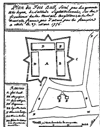
Fig. 6- A page from de Lery's journal provides the only detailed plan of Fort Bull as it was actually constructed. -Counesy, Mowbray Company-Publishers.
\
\.
FORT BULL: A PRE-ARCHAEOLOGICAL STUDY
by
Gilbert Hagerty
21
The bitter competition between the French and the English for the fabulous wealth in fur in the Great Lakes basin had been raging for over fifty years. By 1755 open armed hostilities Had again erupted and spread across the frontier. The French and Indian War had begun, though it was not officially declared until1156.
Intensified military action set in motion a British overall plan to close in on 1he french from the lower St. Lawrence, the Ohio, Lake Ontario, and Lake
Cham-plain. Ontario and Champlain, being close to the main French bases on the upper St. Lawrence, were practically French lakes.
With the exception of their post at Oswego.on the eastern end of the lake-their most important fur trading post in America- the Britfsh had no base from ·which to operate on Lake Ontario. Though geographically strategic, it was weak
militarily.
Major General Johnson's expedition against Crown Point on Lake Champlain
had been launched and forts were started on· ~he upper Hudson (Ft. Edward) and
on Lake George (Ft. William Henry). Though logistics were still a major problem in this sector, General Shirley, then in command of all British military operations, turned his attention to Oswego and Niagara in a desperate attempt to gain control of Lake Ontario.
Not until this time were the British faced with the real necessity of protecting and storing military supplies on their way to Oswego. Oneida Portage, located mid-way between Oswego and Schenectady, the source of supplies, was the only break in the long water route between these two points. Here the shallow Mohawk swung east to join the Hudson, and the narrow Wood Creek sprawled through swamps and waterways to the west, eventually to reach Lake Ontario.
Small forts were built on either end of Oneida Portage in the fall of 1755 to guard the passage and storage of munitions enroute to Oswego. The fort built on Wood Creek at the western end of the Carry was officially called Fort Wood Creek, but it was commonly called Fort Bull in deference to the name of the officer who commanded it then.
On March 27, 1756 Gaspard Joseph Chaussegros de Lery, a French officer, with 362 men made an eleven day march from the present location of Ogdensburg, N.Y. through 130 unexplored miles on the western slopes of the Adirondack wilder-ness to Oneida Carry and struck at Fort Bull. He completely destroyed the fort with its bulging stores, devastating it with the explosion of its powder magazines.
'22
Creek. Soon after the building of the second fort, Oswego fell to Montcalm, and General Webb, who had replaced General Shirley in command of the British forces on Oneida Carry, was overcome by panic at the news. He ordered all fortifications on the Carry destroyed, then retreated to German Flatts.
The sites of the two forts on Wood Creek form an archaeological puzzle. In order to avoid confusion, let us ·identify the original fort, destroyed by de Lery, as Fort Bull and the replacement fort, destroyed by Webb, as Fort Wood Creek.
The exact location of Fort Bull has never been determined. Fort Wood Creek, the ruins of which one' can see today, was erected either completely or partially over the ruins of Fort Bull or on another site altogether, but there is presently no known documentation to establish which of these choices was made.
De Lery left a plan of the fort he destroyed. Since he was a military engineer
of some consequence, it may be assumed that he was familiar with fort plans and
that he can be relied upon to be as accurate as possible under the conditions in
. :whith he teCOrded his data. ·+tis =ale is 41t·the -bottom of ttis:plan ffig. · 6).
The common French unit of measurement generally used was the.'toise. On de Lery's plan he shows a scale consisting of three large and equal units. The first large unit is divided into ten equal sub-units. ·Each of the sub-units has a value of one toise, and each of the large units, a value of ten toises, making a total of thirty toises for the entire length of the scale.
A French toise is equal to six French pieds or 6.4 English feet. Hence the value of each sub-unit is 6.4 English feet, and each of the large units, 64 English feet The total length of the seale would then be equal to 192 English feet
The total length of this scale fits exactly between each of the corner points of de . Lery's fort outline. This scale, when applied to these distances, would make Fort Bull 192 feet square with triangular jogs extending out on each side to form the shape of a star.
Similarly, the distance between the fort gate and the bank of Wood Creek would be a little over 172 feet In this distance and space is a roadway across the front of the fort, a spacious area in which two guard houses are located, and a beach. The beach is scaled to a width of about 45 feet.
In all, the fort and its outside components would occupy 364 feet between the bank of the creek and the fort wall farthest from the creek. There was no moat
shown in de Lery's plan, nor was there a dam shown in the creek.
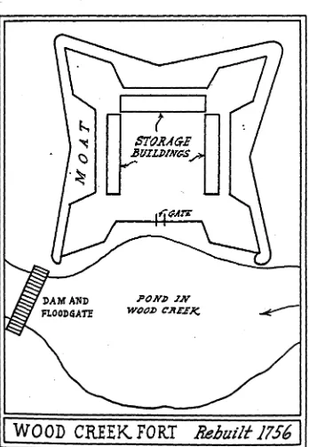
According to de Lery's account, a row of "high pointed stakes with a double row on the inside as high as a· man" enclosed the fort area. There was a wooden gate on wooden hinges which took de Lery's men an hour to chop down before entry. The plan of Fort Wood Creek given in the Crown Collection shows a palisad· ad enclosure with a moat around it on three sides. The fourth side in which the
23
flooding the lowland along the creek by a dam and sluice gate just off the south-west bastion.
Today the outline of this fort and its moat is intact, but the pond area is a pulpy swamp as it has been since the upper waters of Wood Creek were diverted into the Erie Canal at the time of its construction.
The outside points of the bastions on the north, east, and west sides are 180 feet apart and the points of the bastions on the pond side span 200 feet In the northeastern bastion is a circular hole 17 feet in diameter and 4% feet deep. On the Crown map nothing is shown in this bastion.
If we assume that Fort Wood Creek was built directly over Fort Bull, then the latter's outline would have been encompassed by the moat of Fort Wood Creek and most of the subsoil traces would have been destroyed by the digging of the moat . Jf,.we.continue on .this. assumption, we would also have to accept the pond area as containing the beach, the wide open area for the guard huts, and space for the roads since, as mentioned previously, de lery had noted no dam.
At its widest point, the pond basin extends 110 feet from the wall of the fort to the creek bed. This area would be slightly above water level if there were water in the creek. The creek bed is about 35 feet wide and extremely shallow all the
way upstream. .
The 110 foot space in the pond area could not accommodate the 172 feet de Lery estimated between the. creek and the fort wall. Even if it were possible to put all the components de Lery recorded in this space, a more unlikely place could hardly be found. This would be the most undesirable and the least satisfactory place in the entire area for carrying on transportation activities. This land is low
and marshy today and was most assuredly so in 1756. No road could possibly have
existed over this area. At most times of the year the guard huts would have been in water. There would have been no useful purpose served in locating these working areas here when high, dry, solid ground was conveniently accessible nearby.
Immediately bey_ond the present north moat is wet marshy land which would have precluded the erection of Fort Bull on this spot if it were to be placed farther back from the pond area.
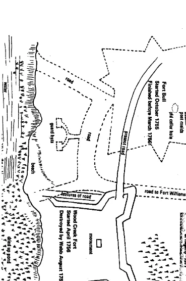
If we look directly west of the Fort Wood Creek ruins, from the southwest
bastion, we see a solid level strip of firm ground slightly above water level,
extend-ing westerly along the creek. Where this level strip of beach tapers and rises to form a high bank there is a large and pronounced indentation in the shoreline of the creek. The indentation is about 130 feet from the southwest bastion of the present
fort ruins. Its topographical nature is such that it can be presumed to have been
Fig. 7- Following de lery's attack on Fort Bull, the Wood Creek Fort was constructed and subsequently destroyed by British General Webb in fear of another French attack. -Courtesy, Mowbray Company- Publishers.
PONJJ JN
W()tJ~ C.RE.EJ'<.
25
Near the southwest baStion a ramp of solid ground ~ises from the flat and
firm shore along the creek and takes on the characteristics of a road running parallel to the western moat. It is not much inore than 12 feet wide and would be an obvious approach to the beach with a wagon or sled. It bears the same relationship to the beach as does the road on de Lery's plan. The vestiges apparent in this junc-tion of a road and the beach offer the most acceptable spot for unloading batteaux from wagons; launching them, and reloading them .for passage down Wood Creek. Along this extended beach would be ample space for 100 feet to accommodate the · sixteen batteaux de Lery found at the water side and destroyed.
While the old pond bed just upstream from this beach is now but a damp, spongy pulp, the creek immediately below this for several hundred feet is filled with water at all times of the year because of the abundant and perennial springs in the creek bed. Here the creek bed appears to be deeper than at any other point in the area The creek widens out and offers plenty of space to handle a batteau with ease.
All the space requirements and topographical features shown on de Lery's plan are found in this open space extending back from the creek immediately to the west of the present ruins of Fort Wood Creek.
In 1~59 some limited exploratory work was done in this area back from the creek and in line with the beach indentation .. Eight postmolds were discovered in a line except the last one, ·which was off at an angle to the northwest. This line of molds was 300 feet from the creek bank, and conforms with that part of de Lery's plan showing the angle which forms the triangular jog or point of the star at mid· section of the north fort wall. On de Lery's plan this star point is shown nearly in a direct line with the beach indentation.
If this line of postmolds is indeed a section of the north fort wall, the angle formed, if extended to the northwest, should continue out for another 32 feet and terminate at the point of the star. This point then would be 332 feet from the creek and 290 feet from the indentation on the creek bank. The location of the postmolds would be then off but 32 feet from the distance de Lery calculated.
In the careful removal of the dark earth from these postmolds, slabs and lumps of clay appeared at irregular levels, mixed with dark soil, extending the entire depth of the mold. The fill was packed loosely and the clay mixed in it was streak-ed with a rstreak-eddish tinge. The tops of the holes were much larger than at mid-section or the bottom. Grains and flecks of charcoal were embedded in the clay, and char· coal was found at the bottom of some holes.
In several instances, the walls of the holes did not go down symetrically, but expanded and undercut the surface outline of the mold to meet the fill in the adjacent holes. The average depth was 26 inches.
iii
~ in
tc- i~i
c:r _. 7t"
oC - on
~ ... 0
...
~is:
~ c !=
9 0 :0 c: i a I.
.
\ \ ',-. ...0
Fig. 8-Counesy, MowbfBY Compsny- Pub/imen.
--
..
-'Old to Fon-Wi;;i~~
.. . ... ....
-
--
-
--
-.
-
-
-
-
-
--
..... ':. ",
on o :I ~ CD c: ~ ~ Born
,
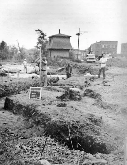
that excav·showing Ci map, show that the fo were looki photos (fig: In H rooms, relT curb and s.
Park Setvic fort leveled ed all too r pltinning fo
In a I
the Nations original fea' we began e: material. 0 who sketch new source of Fairleigh panoramic! National Par It WOI
hand, but, u to the ravagl late 19th ce been moved
alt~ough it a
On thE
~
I
'-i
27
belief that the posts causing these holes were set in a trench (the common method of enclosing an area with pickets) and that the clay dug from the trench was mixed with the dark topsoil and was packed around the base of the posts. When the posts were destroyed or removed, by whatever agency, the resulting holes would, through time, be filled with a mixture of clay and topsoil from the surface. The earth packed between and around the posts at the time of their placement would also be a mixture of clay and topsoil.
With this as a start, further exploration of the Fort Bull area should deter-mine conclusively the exact location of the original fort and end the confusion that presently exists between the sites of Fort Bull and Fort Wood Creek.
28