The Spatial and Temporal Dynamics of Commuting: Examining
the Impacts of Urban Growth Patterns, 1980-2000
by Jiawen Yang
Master of science in Human Geography, Beijing University, 2000
Bachelor of science in Economic Geography, Beijing University, 1997
Submitted to the Department of Urban Studies and Planning in Partial Fulfillment of the Requirements for the Degree of
Doctor of Philosophy MASCHUSEMS INSTJTE
In OF TECHNOLOGY
In
Urban and Regional Planning
At
Massachusetts Institute of Technology
LIBRARIES
September 2005
02005 Jiawen Yang. All rights reserved
The author hereby grants to MIT permission to reproduce
!ROTCH
and to distribute publicly paper and electroniccopies of this thesis document in whole or in part
Signature of author
Departent of ban Studies and Planning r--7 Ti- Ir")005 Certified by
J osef Ferreira Jr Professorf rban Planning and Operations Research
Accepted by TThesis Supervisor
Frank Levy Chair, the Ph.D. committee
The Spatial and Temporal Dynamics of Commuting: Examining
the Impacts of Urban Growth Patterns, 1980-2000
by Jiawen Yang
Submitted to the Department of Urban Studies and Planning on June 1 5th, 2005
in Partial Fulfillment of the
Requirements for the Degree of Doctor of Philosophy in
Urban and Regional Planning at Massachusetts Institute of Technology
ABSTRACT
The dissertation is broadly concerned with the issues of urban transportation and urban spatial structure change. The focus of the research is to interpret the increase in commuting time and distance in the last two decades. The major hypothesis is that a significant proportion of commuting length increase can be explained by land development patterns, particularly the spatial relationship between workplace and residence.
The biggest challenge to address the above problem is to design a method that characterizes job-housing proximity and correlates commuting with job-housing proximity consistently across space, over time and among different regions. A thorough evaluation of existing measures, including ratios of jobs to employed residents, gravity type accessibility and minimum required commuting, shows that all have serious problems.
The dissertation presents a new approach - the commuting spectrum - for measuring and interpreting the commuting impacts of metropolitan changes in terms of job-housing distribution. This method is then used to explain commuting in two sizable but contrasting regions, Boston and Atlanta. Journey-to-work data from Census Transportation Planning Packages (CTPP) over three decades (1980,
1990 and 1990) are utilized. Results indicate that the configuration of commuting
spectrums mirror the changes in urban spatial structure in terms of job-housing proximity. In addition, the spatial variation, temporal change and regional differences in commuting can be significantly explained with job-housing proximity.
Empirical results suggest that spatial decentralization pathways in Atlanta and Boston change the regional patterns of job-housing proximity, attracting people to commute longer distances. The relatively constrained spatial decentralization in Boston results in shorter commuting time and distance than in Atlanta. The empirical results point to a constrained and balanced vision of urban growth for achieving a commuting economy. Both urban growth management and transportation policies are needed to help achieve this vision.
Thesis Supervisor: Joseph Ferreira Jr
ACKNOWLEDGEMENTS
I wish to thank many individuals for their help in bringing this thesis to
completion. Particular thanks are due to the committee members: Professor Joseph Ferreira (Chair and supervisor), Professor Ralph Gakenheimer and Professor Moshe Ben-Akiva. During my five years study at MIT, I had great opportunities to study and work with them. They have helped me a great deal in my academic training, in formulating this research, in securing research resources, and in developing my future teaching career.
My advisor Professor Ferreira has advised me on topic selection and proposal
writing since the very beginning of the dissertation research. He has monitored the research progress carefully. I am also grateful to Professor Qing Shen, who is now working at the University of Maryland. His previous work at MIT has inspired me to start this dissertation topic.
Many thanks to the following people, who have generously provided time in assembling and supplying data used in this research. Paul Reim at Boston Central Transportation Planning Staff (CTPS) has always responded to my data request timely. He sent me detailed documentation of the CTPP data. Nanda Srinivasan at Federal Highway Administration kindly provided the UTPP data of 1980 for both Boston and Atlanta, which is very important to this search. I also thank Tomer Toledo at MIT's intelligent transportation lab, Jeeseong Chung at MIT's department of civil engineering, and Vijay Mahal at Boston CTPS for sharing their data with me.
Several students who took the advanced GIS class studied a topic relevant to this research, using the same datasets. Their experience helps me clarify the goal and the methodology of the dissertation research. I own thanks to these students: Hongliang Zhang, Mi Diao, Zhijun Tan, and Janine Waliszewski. I also thank Raj Singh, Philips Thompson and Peter Maloof for managing the bullfinch oracle server, where the data sets are stored and major spatial analysis is done.
During the long process of my dissertation research, I feel very lucky to have a group of close friends who are always behind me with strong and constant support, which made my life at MIT much easier. I am particular thankful to Yong Shi, Xuan Chen, Ming Zhang, and Xing Wu.
I am deeply indebted to my parents for their love and encouragement. This
dissertation is dedicated to them.
The U.S. Department of Transportation through the Region One (New England) University Transportation Center financially supported this research in the first year. The Brookings Institute urban market initiative's project "Intelligent Middleware for Understanding Neighborhood Markets" provided partial support to the research in the second year. The Transportation Center at the University of Minnesota funded a trip to present part of the research results. Any remaining error is the responsibility of the author alone.
TABLE OF CONTENTS
ACKNOWLEDGEMENTS ...
5
TABLE OF CONTENTS ...
7
LIST OF FIGURES... 10 LIST OF TABLES... 12 CHAPTER 1: INTRODUCTION... 13 1.1 PROBLEM S TATEMENT ... 131.2 OBJECTIVES AND RESEARCH QUESTIONS ... 14
1.3 DISSERTATION STRUCTURE... 16
CHAPTER 2: LITERATURE REVIEW ... 17
2.1 URBAN SETTLEMENT PATTERNS IN SPATIAL DECENTRALIZATION ... 17
2.2 LAND USE STRATEGIES FOR TRAVEL DEMAND MANAGEMENT ... 20
2.3 RESEARCH NEEDS OF COMMUTING IMPACTS OF SPATIAL DECENTRALIZATION ... 2 3 CHAPTER 3: RESEARCH DESIGN... 27
3.1 H YPOTHESES... 27
3.2 STUDY CASES, DATA ... 28
3.3 M AJOR TA SKS ... 29
3.4 H YPOTHESIS TESTING ... 32
CHAPTER 4: BASIC TRENDS OF URBAN GROWTH AND COMMUTING ... 34
4.1 G ROW TH TRENDS... 34
4.2 C OM M U TIN G ... 44
4 .3 SU M M ARY ... 52
CHAPTER 5: EVALUATING MEASURES OF JOB-HOUSING PRO XIM ITY ... 55
5.1 MEASURES OF JOB-HOUSING PROXIMITY ... 55
5.3 METHODOLOGICAL IMPROVEMENT FOR USING MRC... 72
5.3 SU M M A R Y ... . 75
CHAPTER 6: THE COMMUTING SPECTRUM: A NEW METHOD...76
6.1 BA SIC CO N CEPTS... 76
6.2 A MATHEMATIC PRESENTATION ... 79
6.3 COMMUTING IN A STYLIZED REGION ... 82
6.4 SU M M AR Y ... 89
CHAPTER 7: COMMUTING IMPLICATIONS OF JOB-HOUSING BALANCE ... 91
7.1 COMPUTATION OF M EASURES ... 91
7.2 JOB-HOUSING BALANCE AT NEIGHBORHOOD LEVEL ... 92
7.3 COMMUTING AND JOB-HOUSING BALANCE ... 100
7.4 SPATIAL DECENTRALIZATON PATHWAY... 109
7 .5 SU M M AR Y ... 119
CHAPTER 8: COMMUTING IMPACTS OF DECENTRALIZATION PATH W AY ... 120
8.1 V ARIABLES CONSIDERED ... 120
8.2 SPATIAL DIMENSION OF COMMUTING... 122
8.3 IMPACTS OF CHANGING SPAITAL STRUCUTRE ... 126
8.4. IMPACTS OF CHANGING SOCIO-ECONOMIC FACTORS ... 130
8.5 SU M M A R Y ... 132
CHAPTER 9: TOWARD A NEW VISION OF REGIONAL STRUCTURE ... ... .. .... ... ... . ... 133
9.1 CONSTRAINTED AND BALANCED SPATIAL DECENTRLAZATION ... 133
9.2 UNDERSTANDING DECENTRALIZATION CONTEXT ... 137
9.3 STRATEGIES FOR THE PROPOSED VISION... 140
9.4 POLITICAL PICTURE OF THE REGION... 143
9 .5 SU M M A R Y ... 15 1 CHAPTER 10: CONCLUSIONS ... 152
10.1 DISSERTATION C ONTENT ... 152
10.2 RESEARCH CONTRIBUTIONS ... 154
10.3 IMPLICATION FOR METROPOLITAN GROWTH STRATEGIES ... 156
10.4 N EXT STEP RESEARCH ... 157
REFERENCE ... 158
APPENDIX 0: URBAN GROWTH MANAGEMENT IN BOXBOROUGH ... 166
APPENDIX 1. DATABASE DOCUMENTATION ... 174
APPENDIX 2: DICTIONARY OF THE INDICATORS... 176
APPENDIX 3. DATA PROCESSING AND COMPUTATION DIAGRAM ... 185
LIST OF FIGURES
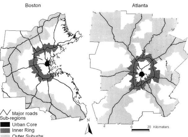
FIGURE 4-1 1990 METRO BOUNDARY AND MAJOR ROADS FOR THE
TW O METROPOLITAN AREAS ... 35
FIGURE 4-2 JOB AND WORKER GROWTH 1980-2000: BOSTON AND A T L A N T A ... 36 FIGURE 4-3 THE URBAN CORE, INNER RING, AND OUTER SUBURB
SU B -R E G IO N S ... 38 FIGURE 4-4 JOB AND WORKER GROWTH BY SUB-REGIONS ... 40 FIGURE 4-5 COMMUTING TIME BY WORKPLACE, 1980-2000 ... 45 FIGURE 4-6 COMMUTING TIME BY WORKPLACE FOR THE BOSTON
M ETROPOLITAN AREA... 47
FIGURE 4-7 COMMUTING TIME BY WORKPLACE FOR THE ATLANTA
M ETROPOLITAN AREA... 48
FIGURE 4-8 COMMUTING DISTANCE BY WORKPLACE IN BOSTON AND A TL A N T A ... 50
FIGURE 5-1 JOB HOUSING PROXIMITY BY JER ... 57
FIGURE 5-2 JOB-HOUSING PROXIMITY BY DEMAND JUSTIFIED
A C CE SSIB ILITY ... 59
FIGURE 5-3 JOB HOUSING PROXIMITY BY MRC... 61 FIGURE 5-4 TRACT LEVEL ACTUAL COMMUTING TIMES FOR BOSTON
20 0 0 ... . . 64 FIGURE 5-5 DEMAND JUSTIFIED ACCESSIBILITY IN A HYPOTHETICAL
CIRCU LAR REG IO N ... 68 FIGURE 5-6 AC VS. MRC IN DIFFERENT MOBILITY SECTORS ... 74 FIGURE 6-1 COMMUTING FOR A HYPOTHESIZED JOB-HOUSING
D ISTR IB U TIO N ... 84
FIGURE 6-2 COMMUTING SPECTRUM FOR BALANCED
DECENTRALIZATION ... 86 FIGURE 6-3 COMMUTING SPECTRUM FOR JOB DECENTRALIZATION
WITH NO RESIDENCE DECENTRALIZATION ... 87 FIGURE 6-4 COMMUTING WITH IMBALANCED DECENTRALIZATION 88 FIGURE 7-1 BOSTON RESIDENCE MRC BY TRACT IN 2000 ... 92
FIGURE 7-2 BOSTON RESIDENCE PMC BY TRACT IN 2000 ... 92
FIGURE 7-3 BOSTON RESIDENCE COMMUTING TIME BY TRACT IN 2000 ... . . 9 5 FIGURE 7-4 BOSTON RESIDENCE COMMUTING DISTANCE BY TRACT IN 2000 FIGURE 7-5 FIGURE 7-6 FIGURE 7-7 FIGURE 7-8 FIGURE 7-9 FIGURE 7-1 FIGURE 7-1 FIGURE 7-1 FIGURE 7-1 FIGURE 7-1 FIGURE 7-1 ... 9 5 ATLANTA COMMUTING TIME BY TRACT IN 2000 ... 97
ATLANTA COMMUTING DISTANCE BY TRACT IN 2000 .... 97
ATLANTA MRC BY TRACT IN 2000 ... 97
ATLANTA PMC BY TRACT IN 2000 ... 97
PLOTS OF MRC, AC & PMC (BOSTON 1980)... 101
1 PLOTS PLOTS PLOTS PLOTS PLOTS OF MRC, OF MRC, OF MRC, OF MRC, OF MRC, AC & PMC AC & PMC AC&PMC AC & PMC AC & PMC COMMUTING AND SPATIAL BOSTON 1990)... 102 BOSTON 2000)... 103 ATLANTA 1980)... 106 ATLANTA 1990)... 107 ATLANTA 2000)... 108 DECENTRALIZATION IN B O S T O N ... 110
FIGURE 7-16 CORRELATING THE TEMPORAL CHANGE OF AC AND MRC, PMC FROM 1980 TO 2000 (BOSTON)... 113
FIGURE 7-17 COMMUTING AND SPATIAL DECENTRALIZATION IN A T L A N T A ... 114
FIGURE 7-18 CORRELATING THE TEMPORAL CHANGE OF AC AND MRC, PMC (ATLANTA)... 117
FIGURE 9-1 SENSITIVITY OF COMMUTING TO TRAVEL DISTANCE (PA R A M E TE R U )... 139
FIGURE 9-2 LOCATION OF SELECTED FOUR MUNICIPALITIES IN THE B O STO N R EG IO N ... 144
FIGURE 9-3 COMMUTING IN ESTABLISHED SUBURBAN ECONOMIC C E N T E R S ... 146
FIGURE 9-4 MUNICIPALITIES WITHIN NEW SUBURBAN ECONOMIC C E N T E R S ... 14 8
LIST OF TABLES
TABLE 4-1 THE SPATIAL ANALYSIS UNITS FOR BOSTON AND
A T L A N T A ... 37
TABLE 4-2 NUMBER OF JOBS AND WORKERS BY SUB-REGIONS... 41 TABLE 4-3 DENSITY OF JOBS AND WORKERS IN BOSTON AND
ATLANTA (PERSON / SQ KM)... 43
TABLE 5-1 CORRELATION COEFFICIENTS FOR BOSTON 2000... 62 TABLE 5-2 CORRELATION BETWEEN PROXIMITY MEASURES AND
C O M M U T IN G ... 66
TABLE 5-3. REGRESSION MODEL FOR ACTUAL WORKPLACE
COM M UTING TIM ES ... 67
TABLE 7-1 AC, MRC AND PMC FOR DIFFERENT SUBREGIONS
(B O S T O N )... ... 110
TABLE 7-2 AC, MRC AND PMC FOR DIFFERENT SUBREGIONS
(A T L A N T A )... 115
TABLE 8-1 INTERPRETING THE SPATIAL VARIATION OF COMMUTING
(1 ) ... 1 2 3
TABLE 8-2 INTERPRETING THE SPATIAL VARIATION OF COMMUTING (2 ) ... 12 4 TABLE 8-3 INTERPRETING THE SPATIAL VARIATION OF COMMUTING
(3 ) ... 12 5
TABLE 8-4 REGRESSION RESULTS OF COMMUTING IMPACTS OF
DECENTRALIZATION (TIME)... 128
TABLE 8-5.REGRESSION RESULTS OF COMMUTING IMPACTS OF
DECENTRALIZATION (DISTANCE)... 130
TABLE 8-6 COMMUTING IMPACTS OF DECENTRALIZATION
(SOCIO-ECON OM IC V ARIA BLES) ... 131
TABLE 9-1 COMMUTING IMPACTS OF DECENTRALIZATION (TEST JER M E A SU R E S)... 136 TABLE 9-2 JOB AND WORKER COUNTS IN REPRESENTATIVE
CHAPTER 1: INTRODUCTION
1.1 PROBLEM STATEMENT
Pubic concerns about congestion, environment quality and energy consumption are motivating planner to seek better visions for growing the metropolitan areas smartly (Wheeler, 2000, Public Policy Institute, 2000, 2002a, 2002b). More specifically, studies of urban commuting trends have debated on the commuting impacts of spatial decentralization. Broadly speaking, two schools of though emerge in the literature. The first school regards spatial decentralization as one of the major causes that lengthen commuting (Cervero, 1989, 1991, 1996a). The second school argues spatial decentralization actually helps shorten commuting. They argue that, although commuting time is the same or even increasing over time, without spatial decentralization, commuting time would increase even more
(Guiliano and Small, 1993; Crane and Chatman, 2005).
No matter what the conclusion is, these studies follow the same line of reasoning, that is they employ the same general understanding of the relationship between commuting and urban spatial structure - urban transportation is the demand derived from the underlying activity system and urban spatial structure should be an important determinant of urban transportation. The changing spatial relationship between workplace and residence, therefore, has significant impacts on commuting. Whether commuting in the real world increases or decreases depends on how urban spatial structure evolves over time, and consequently what commuting impacts it actually has. From this perspective, many questions have been debated but without any clear answer.
First, from a cross-sectional spatial perspective, quantitative studies of the relationship between urban spatial structure and commuting lead to entirely different conclusions on the need for balanced urban growth to shorten commuting and relieve congestion. Researchers can't agree with each other on whether urban spatial structure can explain patterns of journeys to work. Second, from a temporal perspective, researchers can't agree with each other whether current urban growth trends actually imply more commuting. Neither can they agree with each other how current urban growth trends change actual commuting
patterns.
The lack of agreement in the research leaves a great information gap in developing urban growth strategies for a transportation benefit in today's metropolitan area. As debates go on from 1980s, urban spatial decentralization has continued, and commuting time has kept on increasing. More recently, census data shows that from 1980 to 2000 commuting time keeps on increasing in the presence of continual spatial decentralization. The increase of commuting time is much more significant from 1990 to 2000 than that in the previous decade (Rossetti and Eversole, 1993; McGuckin and Srinivasan, 2003).
Research opportunities of commuting impacts of spatial decentralization are emerging. First, with the newly available data of CTPP 2000, three consistent census packages for transportation planning are available to examine the commuting behavior and urban growth trends at fine detailed geographical level. Second, urban growth management has been implemented in the last two decades, creating both successful and unsuccessful stories. More research effort is needed to inform the policy-making for a better urban growth strategy.
1.2 OBJECTIVES AND RESEARCH QUESTIONS
Taking these opportunities, this project revisits the debate on the commuting impacts of urban growth trends. The project is centered on one question on the American urban growth process: To what extent do urban growth patterns contribute to the spatial variation and the temporal trends of commuting in the last two decades? The purpose of this project is (1) to reveal the link between the increase of commuting time and the spatial and temporal processes of job decentralization; (2) to evaluate the evolving urban spatial structure in the light of job-housing balance; (3) to clarify the potential effectiveness of urban growth management that aims to achieve balanced urban growth for shortening commuting and relieving congestion.
To achieve these objectives, the research asks the following four specific questions:
1. Are current job-housing balance measures sufficient enough
to represent the spatial relationship between workplace and residence? The measurement problem is important not because different measures show different numeric correlation between commuting and land use patterns, but because not all
aspects of land use patterns are equivalent in inducing commuting change. A job-housing balance program guided by an inferior land use measure will be ineffective to correct the transportation problem. Therefore, before we ask the questions whether a certain job-housing balance strategy is effective, we should ask the question what indicator is used to measure job-housing balance and whether this indicator represents the essential commuting-inducing aspects of land use patterns. 2. From a temporal perspective, have current urban development
trends increased job-housing imbalance? In a monocentric region, commuting length is completely determined by job-housing distribution. As urban spatial structure moves from monocentrality to polycentrality and even to dispersal, the perfect correlation between job-housing distribution and commuting length disappears. The spatial proximity between workplace and residence can increases or decreases, resulting in different transportation outcomes.
3. From a temporal perspective, to what extent can the change of
commuting duration be explained by current urban development patterns? In the decentralization process, many socio-economic variables are changing besides the change in job-housing balance. These factors include the increase in female participation in the workforce, the concentration of multiple worker families in the suburbs and emergence of high-income community in the outer suburbs. Even for job-housing balance, both the local proximity and regional patterns of job-housing distribution are changing. One must be careful in evaluating the commuting impacts of spatial decentralization.
4. To what extent is balanced growth a plausible solution to shortening commuting and relieving congestion in today's metropolitan area? Current discussion of job-housing balance mainly focuses on the need of balancing employment and housing at various localities. Stemming from this, locally balanced growth has been proposed to emphasize the need of a fair share of affordable housing. Market-oriented growth has been proposed to exclude any additional planning intervention. Based on the answers to the above three questions, these existing strategies will be evaluated and possible new strategies will be emphasized.
1.3 DISSERTATION STRUCTURE
This dissertation is divided into ten chapters. Chapter 1 presents research problems and questions. Chapter 2 presents existing literature of urban transportation and land use planning, particularly the literature of commuting impacts of spatial decentralization. Research needs are identified in this chapter. Chapter 3 presents the research design. Specific hypotheses and tasks are described. Chapter 4 examines the spatial decentralization pathways in Boston and Atlanta in terms of job and worker decentralization, mobility, and commuting. Chapter 5 offers a comparative evaluation of existing measures of job-housing balance. Chapter 6 develops the new commuting spectrum method to measures the relationship between workplace and residence in a setting of spatial decentralization. Chapter 7 examines the spatial decentralization pathways with an eye to its commuting impacts. Chapter 8 estimates the contribution of spatial decentralization to the increase in commuting time and distance. Chapter 9 proposes a new vision of urban growth for shortening commuting and relieving congestion. The concluding chapter 10 summarizes the key points of the dissertation research and describes contribution of this research.
CHAPTER 2: LITERATURE REVIEW
Three bodies of literature address the questions raised in this research. Economics and geography literature of urban development patterns provides general insight into the dynamic relationship between urban spatial structure and commuting behavior. Studies of transportation demand management in general and land use strategies in particular direct our attention to how alternative spatial processes of urban development result into different transportation outcomes, both at the local and regional scale. Recent planning literature on the relationship between urban spatial structures and commuting patterns demonstrates the frontier of the research and the focus of the policy debate in this area, and offers valuable perspectives and tools to tackle this problem.
2.1 URBAN SETTLEMENT PATTERNS IN SPATIAL
DECENTRALIZATION
The importance of transportation in shaping urban spatial patterns are particularly addressed in the classic urban economic models, which are built upon the assumption that location decisions are mainly determined by a desire to reduce the sum of land cost and transportation cost, resulting in the minimization of total commuting cost in the urban area. In a monocentric urban space, the intensity of land use and length of trips is primarily a function of the mobility condition (Alonso, 1964, Herbert and Stevens, 1960; Wheaton, 1974; Senior and Wilson, 1974). High density of land utilization and short trip length is associated with a high cost for per unit of travel distance. Lowering travel cost increases land consumption when the population is given. Simple as it was, this ideal has survived to today, when urban decentralization, congestion, land and energy consumption, and the associated deterioration of environmental quality have become a critical issue for public policy.
2.1.1 Spatial decentralization of urban space
One well-known phenomenon in American urban growth history is the increase in private ownership of automobiles and the corresponding spatial decentralization of households. The causal relationship between the dispersion of urban activities
and the changing mobility conditions that evolves from streetcars to automobiles generally fits the standard economic model of a monocentric city. However, further decentralization of manufacturing industry and retail industry, followed by office construction in the suburbs have created centers beyond the central city, thus moving the urban space into a polycentric spatial structure, which is fundamentally different from the monocentric urban space.
The rich landscape in the process of decentralization is described by the growing geography literature, which depicts urban spatial structure with the spatial concentration or dispersion of business, residence and other activities. With this approach, studies of Los Angles, Atlanta, Chicago, and Milwaukee generally describe the modern metropolis with a polycentric framework (White, Binkley and Osterman, 1993; McDonald and Prather, 1991; Clark and Kuijpers-Linde, 1994; Ingram, 1997). Waddell and Shukla (1993) in a study of Dallas, describe a polycentric structure that emphasizes the role of corridors along major arteries. Gordon and Richardson's study of the spatial structure of Los Angles depicts this region as a dispersed metropolitan area that is eventually evolving beyond polycentricity (1996). Their study finds that the share of employment in the metropolitan area in job centers is declining. Besides the effort to describe the urban spatial structure, researchers have also listed factors driving the spatial process of urban decentralization, to name a few, auto mobility, central city crime, education quality, and technology innovation of the manufacturing industry (O'Sullivan, 2000; Holzer, 1991; Cultler, Glaeser and Vidgor, 1999).
Underlying these efforts to describe the spatial patterns of urban decentralization are researches' concerns about the side impacts of current urban growth trends, which is well documented by the increasing smart growth literature. Nation wide studies of the consequences of urban sprawl finds that more sprawling regions have more problems in urban transportation, air quality as well as health conditions of their residents (Ewing, Pendall and Chen, 2003; McCann and Ewing, 2003). A report published by the Brookings Institution's Center on Urban and Metropolitan Policy (2000) summarizes studies of urban growth patterns in the Atlanta metropolitan area. The work outlines the imbalance of growth in the light of the spatial distribution of population, income, race, schools, employment, housing and transportation. It also links urban congestion, poor air quality and racial segregation in this metropolis to the imbalanced development patterns.
2.1.2 Job-housing balance in the decentralized urban space
Job-housing balance is a particular perspective to view land development patterns. Broadly speaking, job-housing balance examines the spatial distribution of jobs
and housing with respect the spatial relationship between workplace and residence.
Two issues stand out in the existing patterns of job-housing distribution in the metropolitan areas of the USA. On the one hand, zoning for large lot size and single use lowers land use density, increasing spatial separation of workplace and residence. On the other hand, there are affordability and desirability problems. The housing close to the job location may not be affordable for a certain group of low-income workers or the neighborhood is not desirable for a certain group of high-income workers. So there are both spatial and social aspects of job-housing balance (Cervero, 1989). While researchers mention the spatial and social aspects in the research, there is no commonly accepted definition for such terms as job-housing balance and job-job-housing mismatch. One cannot tell the exact meaning of the term until reading the arguments following it. Some researchers use job-housing balance referring to both the spatial and social dimensions (Guilano and Small, 1993). However, some other researchers use job-housing mismatch to represent both of them (Cervero, 1991). For the convenience of discussion, in this thesis, the spatial dimension is referred to as job-housing separation, and the social dimension, housing mismatch. The terms housing balance and job-housing imbalance include both the spatial and social dimensions.
Job-housing balance is a particularly useful way to represent the decentralized urban space. It describes urban spatial structure by measuring the location of jobs and housing units relative to each other, rather than defining centers or sub-centers. This approach has been adopted in a great number of studies to help understand the relationship between urban transportation and the spatial distribution of jobs and housing. Researchers construct indicators of job-housing ratios or job/worker accessibility with detailed spatial disaggregation and use the indicators for travel demand modeling (Cervero, 1989; Shen, 2000). The measurable feature of job-housing balance enhances its role as a workable urban growth strategy, as what gets measured gets attention (Sawicki and Flynn, 1996). The evolving urban spatial structure, however, has never been empirically examined systematically in the light of job-housing balance with measures of explicit transportation dimensions. Two hypotheses have been developed, namely, the co-locate hypothesis and the fiscal zoning hypothesis. The co-locate hypothesis is advanced in an effort to explain the commuting paradox by Gordon, Richardson and Jun (1991). They remark that the stable or even decreasing commuting time in the presence of increased congestion is primarily because employment and housing location are self-adjustable once commuting pressure increases. The spatial decentralization process actually implies a commuting
economy. Therefore, policies should be designed to break down the barriers to spatial decentralization. The fiscal zoning hypothesis is also advanced as a response to region wide concern about transportation. Unlike the co-locate hypothesis, it argues that jobs and housing are farther separated from each other or becomes more mismatched because of low-density development, reliance on auto usage, and exclusionary zoning practice. Though commuting pressure has the potential to motivate balanced urban growth, the market mechanism to ascertain the self-adjustment may not be available because local communities control land development, thereby creating quantitative and qualitative mismatches of jobs and housing (Cervero, 1989, 1991, 1996a). The co-location of jobs and housing may not happen owing to another reason, which is hypothesized by Timothy and Wheaton (2001), that the increased commuting cost is sustained by increased wages, which comes from the economy of spatial agglomeration. The co-locate hypothesis and its opponents point to very different direction of urban growth trends in the light of job-housing distribution and contrasting arguments about the need for job-housing balance programs.
Therefore, there is a need to examine the urban growth trends in the light of job-housing balance in the American metropolitan areas. It is not only for the purpose of confirming one of the hypothesis, but also to identify the need for job-housing balance programs, one of the most important concepts for accessibility oriented planning (Cervero, 1996b). This is one of the goals this dissertation will address.
2.2
LAND USE STRATEGIES FOR TRAVEL DEMAND
MANAGEMENT
Travel demand management marks a new era of transportation planning. Among its various approaches, strategic land management invites special interest not just because transportation investment to build more capacity is subject to more environmental and financial constraints, but also because travel demand is essentially a derived demand to take part in the various urban activities dispersed across the region (Altshuler, Womack, and Pucher, 1981; Won, 1990; Weiner,
1992; Willoughby, 2000; Ashford, 2002). Therefore, urban growth management
and strategies are really long term and could possibly change travel patterns to an extent that can never be achieved through other approaches (TRB, 1997; WBCSD
2.2.1 Land use strategies in general
The attention to land use strategies for transportation demand management arises from the concern about the negative transportation impacts of the sprawling development patterns. Studies of the relationship between travel demand and land development patterns show that in the USA there is a significant difference in mode share, VMT and energy use between people living in the traditional neighborhoods and those living in the new suburban areas. International studies comparing USA with other developed countries also point out significant differences in urban transportation between USA and Western European cities and identify land development patterns as the leading factor creating the difference (Newman and Kenworthy, 1992). The concerns about the negative transportation and environmental outcome of current urban development patterns, together with other social concerns about the spatial segregation by race and income, have motivated policy-makers to formulate land use strategies to move the metropolitan areas in alternative directions.
In today's USA, notable among the land use approaches are the pedestrian and transit oriented development of 'new-traditional' communities, and regional wide strategies such as urban growth boundary and job-housing balance (Hirasuna,
1999). The first approach emphasizes the neighborhood level land development
patterns. It proposes densification, mixed land use, friendly pedestrian environment, as apposed to the low-density, separated land use patterns and road network designed exclusively for auto mobility (Friedman, Gordon, and Peers, 1994). The application of GIS technology enables researchers to measure neighborhood land use patterns with various indicators and then use them in travel demand models (Hess, etc, 2001; Srinivasin, 2000; Krizek, 2001).
The second approach is more regional, aiming to reduce the imbalance in growth
by adjusting locations of housing, working, entertainment and shopping (Frost
and Spence, 1995; Kuhl and Anderson, 2000; Business, Transportation and Housing Agency, 2002). Studies of the second approach generally adopt accessibility measures to present the spatial proximity of various activities and use them in statistical models to evaluate its transportation impacts (Wachs and Kumagai, 1973; Ben-Akiva and Lerman, 1985; Hansen and Schwab, 1987, Shen, 2000). Studies on travel impacts (such as trip length, trip frequency and mode choice) of land development patterns are well summarized by Crane (2000), who concludes that the results are not conclusive and further studies with refined measurement of land use patterns and better statistical models are needed.
2.2.2 Job-housing balance strategy
The strategy of job-housing balance stands out as an urban growth strategy for a better transportation and environmental outcome. It promotes a region wide management of urban growth to achieve a balanced spatial distribution of jobs and housing. It occupies the middle ground between constrained visions of metropolitan development, and dispersing visions of rapid spatial decentralization. Supporters of the strategy believe that, within the framework of jobs-housing balance, many of the negative consequences of spatial decentralization are avoidable if work sites and home sites are closer to each other (Downs, 1994).
For some scholars, the job-housing balance programs are a practical option that makes urban growth pattern more compatible with transportation capacity in the long run (Cervero and Landis, 1995). In some cases, jobs and home sites may be close enough together to facilitate walking and bicycling; in others, jobs and residential clusters may become large enough for public transit to be effective. In general, however, individual and social benefits of location are presumed to accrue even if the commuter drives the short distance to work (Hansen, 1989; Cervero, 1989; Allen, 1993; Shen, 2000, Wang, 2001; Landis, Deng and Reilly, 2002). Besides asserting the significance of job-housing balance, researcher even point out different aspects of job-housing balance. Levinson (1996) in his study of Washing D.C., points out that making job closer to residence is more significant than moving the housing units. Shen (2000) in his study of Boston reveals that the transportation impacts of the social and spatial factors are actually mixed together. Land use programs promoting job-housing balance are now incorporated as key components of "smart growth" initiatives. Sprawling states such as California and Georgia have pushed job-housing balance programs into planning practices (Binger, 2001; LeGates, 2001; Atlanta Regional Commission, 2002).
The support for these programs, however, is still limited. For example, Guiliano
(1991, 1995) remarks that job-housing balance may not be the right solution for
the current transportation and environment problems because commuting cost is not the determinant factor of residential location choice. The linkage between transportation and land use is weakening owing to the fact of the declining real cost of commuting, and the stability of urban infrastructure investment and housing stocks. In a quantitative study on Los Angles, Guiliano and Small (1993) conclude that urban spatial structure can explain only a limited portion of commuting and they hypothesize, without proving, that other factors overshadow transportation cost in residential location decision. Peng (1997), generally supports land use strategies for transportation demand management, but argues
that a balanced strategy may actually not do any good because it works only when imbalance is at an extreme. What's more, too much of a balanced job-housing distribution makes transit unsurvivable. Therefore, policies favoring sub-centering and transit-oriented development are more desirable.
Guiliano and Small's study on Los Angles is later explained by Levin (1998) in a different way. The fact that required commuting accounts for about 50% of real commuting means that job-housing balance programs have real potential to address the commuting problem. The existence of these conflicting viewpoints, however, does invite deeper studies on the transportation impacts of land use programs. The question to be addressed is not only whether land use programs are significant, but also how significant they are when compared to other factors such as mobility and the social-economic status of the commuter, and how effective they are when compared to other strategies. In this research, we deal with the normative strand, which focuses on the need of the job-housing balance strategies,
by investing in the positive strand, which aims to correctly quantify the magnitude
of relationship between commuting and job-housing distribution.
2.3 RESEARCH NEEDS OF COMMUTING IMPACTS OF
SPATIAL DECENTRALIZATION
Commuting was the dominant trip for urban passenger transportation. After the significant increase of the non-work trips since the last several decades, commuting trips still accounts for 15% of total trips (Bureau of Transportation Statistics, 2003). Commuting patterns (including the origin and destination, the duration and mode share) have changed significantly as urban space decentralizes (Rossetti and Eversole, 1993; McGuckin and Srinivasan, 2003). Today, commuting trips by automobile is the major source of congestion (Bureau of Transportation Statistics, 1997, 2003).
2.3.2 Job-housing balance debate
Researcher have devoted significant effort to understand why people need to commute much more than what is required by the urban spatial structure and why commuting duration varies among different parts of a region. Studies joining the debate on the significance of job-housing balance can be broadly divided into two groups, those asserting the significance of job-housing balance and those not. For example, Cervero's study on San Francisco (1991, 1996), Wang's study on Columbus (2003), and Shen's study on Boston (2000) are on the supporting side. These studies argue that urban spatial structure in the light of job-housing
distribution has significant impacts on commuting behavior. The relationship between commuting and job-housing distribution is well implied by the definition of commuting, the journey between residence and workplace. In a monocentric urban space, particularly commuting length is determined by the residence location with a reference to the sole employment center. As urban space moves toward or even beyond polycentricity, this perfect relationship does not exist anymore. But one should still expect a significant relationship.
Guiliano and Small' study on Los Angles (1993), Wachs' study on southern California (1993), and Peng's study on Portland, Oregon (1997) are on the disapproving side. They point out job-housing balance is not significant in explaining commuting duration and job-housing balance programs are not effective to shorten commuting duration. For example, Guiliano (1995) points out that the required commuting implied by job-housing distribution is usually less than 50% of the actual commuting. Studies also reveal various other factors contributing to commuting duration. There has been an increase of woman participation in the workforce. Women usually have more housing care responsibility, resulting in more trip chaining during commuting. There is also the increase of households with multiple wage earners, which make it hard to locate home close to multiple job locations. Further more, the rate of job turnover and business relocation is also beyond the pace of housing adjustment (Hozler, 1991).
After many studies, the situation today fits the comments made by Cervero (1996a) eight years ago, for studies saying job-housing balance is not important, there is at least the same number of studies saying it is.
2.3.2 Methodological problems
While each research has its own merit, significant improvement still can be made if more effect can be devoted to address the following methodological problem. They are the problem of indicator selection, the problem of location inertia in residential location decision, and the inadequate treatment of mobility conditions. First, there is a problem of indicator selection. Researchers have developed mainly three kinds of measurement for housing distribution: namely job-housing ratios, gravity-type accessibility and minimum required commuting. Job-housing ratio is computed at the town or county level or with floating catchment areas (Cervero, 1989; Landis, etc, 2002, Peng, 1997). It is easy to compute. However, job-housing ratio doesn't measure the spatial separation of jobs and housing. The same set of ratios may result in very different commuting patterns, depending on how the analysis units are spatially arranged. As for job
accessibility, it considers job-housing balance as a function of the underlying transportation system and the geographical distribution of job and housing (Morris, etc, 1977; Hansen, 1987; Shen, 2000). However, it cannot distinguish the impact of job-housing distribution from that of the underlying transportation system. As for minimum required commuting, it adopts an optimization approach and has the conceptual advantage by directly measuring job-housing separation (Hamilton, 1989; Guiliano and Small, 1993). However, the ways to set up the objective function and constraints are arbitrary. Given the fact that these indicators are so different from each other, different research can hardly be compared meaningfully. Therefore, it is necessary to offer a comparative evaluation of the existing indicators and develop methodologies that can interpret commuting in relation to settlement patterns.
The location inertia problem is another issue not well addressed in the existing literature. Location inertia problem happens when households continue to live with congestion and long commuting rather than move to another residence location because of moving cost or the lack of information. Cross-sectional models adopted by existing studies derive the benefit of job-housing balance strategy by comparing commuting patterns among areas with different levels of job-housing balance. The implication of this approach is that once job-housing balance is improved in a neighborhood, location adjustment of residence or workplace will follow. However, many researchers point out, without proving, that immobility of residence or workplace is significant in weakening the impact of job-housing balance strategies (Rouwendal, 1998; Cervero, 1989). Therefore, cross-sectional models tend to overestimate commuting impacts of job housing balance. To present it in another way, the significance of the relationship between housing distribution and commuting duration does not necessarily mean job-housing balance strategies are effective solutions to the transportation problem.
A temporal perspective therefore is needed. The temporal perspective has firstly
been presented in the "commuting paradox" (Gordon, etc, 1991), which hypothesizes, without proving, that spatial decentralization brings jobs and workers closer to each other, thereby shortening commuting length. Several empirical studies have been carried out to examine the commuting - land use connection over time. Wachs, etc (1993) studies the changing commuting in relation to job-housing balance for a specific job center in a multi-centric region
and concludes that the increased commuting time can be attributed to congestion rather than job-housing imbalance. The research, however, does not examine whether the increase in congestion has something to do with the changing job-housing patterns across the region. A more recent paper (Crane and Chatman, 2004) uses seven waves of American housing survey (1985-1997) to research the
commuting impacts of employment decentralization across the USA. It finds that workers in regions with more employment decentralization have shorter commuting distance. However, this research does not measure household decentralization. Therefore, it only proves that employment decentralization tends to shorten commuting when households are already decentralized. Considering the fact that employment decentralization and household decentralization are two chained processes and decentralized employment enables households to live farther away from the urban core, the commuting impact of spatial decentralization would not be clear until suburban household and employment
growth has been considered simultaneously.
Commuting and urban development information at different time points is essential to obtain a better estimation of the commuting effectiveness of a
job-housing balance strategy.
The existing studies usually either study spatial aspects or the temporal aspects. For studies of the spatial variation of landuse patterns and their transport implication, they usually neglect the fact that the revealed spatial variation of commuting is a snapshot of changing commuting behavior conditioned on the evolving mobility conditions in the process of spatial decentralization. The revealed patterns are likely at a status of disequilibria. Therefore, studying the spatial aspects of commuting without sufficient consideration on the temporal trends provides biased answer to the effectiveness of job housing balance for transport and environment benefits, as is already argued above. For studies of the temporal trends of commuting, the richness of the social and economic setting of the urban spatial structure, such as imbalanced growth of business, housing and the uneven distribution of mobility conditions in a fine detailed geographical framework, is missing. However, these factors are very important for policy-making on urban growth management for shortening commuting and relieving congestion. Therefore, an integration of the above concerns about the spatial and temporal features of the problem, that is an analysis of commuting in relation to urban growth patterns at different geographical scales within a multiple year context, is essential to provide a robust answer the commuting impacts of spatial decentralization.
CHAPTER 3: RESEARCH DESIGN
The research hypothesizes that job-housing balance can interpret a significant portion of commuting time and distance. If measured correctly, job-housing balance can interpret not only the spatial variation of commuting from one neighbourhood to the other, but also the temporal change of commuting from one decade to the other, and the regional differences from one region to the other. Toward this end, the research examines commuting impacts of urban growth trends in two contrasting metropolitan areas over a period of twenty years.
3.1 HYPOTHESES
The research has the following four intertwined hypotheses, which are associated with the four research questions respectively.
Hypothesis 1: MRC is the best measure among the three to link job-housing balance and commuting. Yet new measures still needs to be developed to sufficiently reveal the commuting -land use linkage. Among the three categories of measures, MRC is the only one measuring job-housing balance with an explicit commuting distance. The value of MRC tells the minimum effort for commuting based on a given job-housing distribution. It is reasonable to expect that a higher MRC for a locality would result in a higher actual commuting. An increase in MRC over time would like in a longer actual commute. In addition, a region with a high MRC will have a longer commuting time and distance. However, the workplace-home relationship presented by MRC may not be enough to represent the commuting-job/housing linkage. By matching jobs and closest available workers, MRC leaves out the regional configuration of job-housing balance, which is important in the decentralized region.
Hypothesis 2: Over the study period (1980-2000), spatial decentralization decreases job-housing balance and implies longer commuting. Keep household decentralization constant, employment decentralization would increase job-housing balance. However employment and household decentralization are actually two chained processes. Employment decentralization is encouraged by household decentralization and employment decentralization further enables
household decentralization. When the mobility condition is high, households may have no desire to locate homes closer to jobs in a decentralized region.
Hypothesis 3: Over the study period (1980-2000), the regional dispersal of jobs and workers, rather than the local balance of jobs and workers, increases commuting. As urban spatial structure moves from monocentrality to polycentrality and even to dispersal, an increasing proportion of households and firms are located at less dense and higher mobility areas, commuting cost is taking a decreasing role in location decisions. Although the local balance of jobs and workers still have some influence on commuting, the reliance on geographical proximity decreases obviously. For an average household, its workers are more likely to seek for jobs far away. Therefore, the spatial patterns of jobs and labor force in the vast region, compared to local separation of workplace and residence, are gaining more affluence on commuting. In addition, the local balance of jobs and workers is mainly determined by zoning regulations, which has long been in place long before the 1990s. Over the last two decades, the major changes come in the regional, rather than the local, aspects of job-housing distribution. Therefore, commuting time can be attributed mainly the regional change of job-housing patterns.
Hypothesis 4: Constrained and balanced spatial decentralization can shorten commuting. In areas with higher job-housing separation at the local level, an increase in local job-housing balance reduces the minimum standard for commuting, thereby, potentially reduces commuting. The improvement of job-housing balance with affordable job-housing programs, therefore, should help shorten commuting to some extent. While in areas with higher mobility, the improvement of local job-housing balance may not be so effective because people's commuting are less constrained by the local imbalance. Other urban growth management programs that change the regional patterns of job-housing distribution, such as suburban clustering, should be more effective in shortening commuting.
3.2 STUDY CASES, DATA
3.2.1 Boston and Atlanta
The research selects two metropolitan areas, Boston and Atlanta. This selection is justified by the growth history of these two regions. They are both at the second tier of the USA's urban system hierarchy. The complexities of their commuting and geographical variation are much more manageable than metropolitan areas
such as New York and Los Angeles. They both have experienced increased commuting duration while the economy and population have grown and their urban areas have expanded in the last two decades. Atlanta has experienced intensive urban sprawl in the last several decades, which has resulted in serious congestion and air pollution. Consequently, a metropolitan authority has been established and granted the power to monitor transportation investment and to encourage land development that fits better the transportation and environment goals. The Boston metropolitan area is somewhat different. It has kept a prosperous central city while new development disperses to Route 128 and further to 1-495. Studying commuting behavior in two metropolises with comparable size but different urban growth trends tests the transferability of major observations while maintaining a meaningful comparison.
3.2.2 Data
The key data sets are the urban transportation planning packages from the last three censuses, including UTPP 1980, CTPP 1990 and CTPP 2000. Every CTPP data contains information of three categories. A residence table summarize housing, labor force, commuting, and other socio-economic information with places viewed as residence sites. A workplace table summarizes employment and commuting information by workplace. In addition, a commuting table summarize the commuting information (count, mode and time) between origin and destination. The data is detailed in terms of geography, geo-coded at the level of block groups, census tracts, or transportation analysis zones. The associated zonal data boundaries help to visualize and analyze spatial patterns. In this research, census tracts are the basic analysis units.
This time span of 20 years allows the proposed project to examine the commuting impacts of job-housing distribution with location inertial problem accounted. The census data used in the study are spatially fine-grained, which makes it possible to examine the growth-commuting linkage with flexible spatial framework.
3.3 MAJOR TASKS
The major research activities can be divided into four categories: 1) data process and indicator computation; 2) Indicator evaluation and methodology development; 3) Evaluation of growth trends and commuting patterns; 4) Estimating commuting impacts of spatial decentralization.
3.3.1 Data process and indicator computation
The research is mainly quantitative and relies on computation and modeling. GIS, RDBMS and optimization procedures will be utilized in this study. CTPP data contain commuting matrixes of a large volume. Relational database managers such as Oracle are used to process the gigantic datasets, storing temporary results and implementing procedures to generate indicators. GIS is utilized to derive spatially related commuting information such as commuting route distance, which is not available in the census data. It is also used to visualize commuting patterns and job-housing distribution. Another key computational component is the optimization procedure, which is used to construct minimum required commuting, a refined series of indicators proposed to measure the spatial structure and derive indicators of mobility conditions. Algorithms for large-scale optimization models with several million variables are written in Cplex and implemented on multi-processor Unix machines with 4 GB of memory. A region with a thousand-TAZ area can be handled adequately. MIT's computing infrastructure provides the core technology.
This project examines trends of job-housing distribution and commuting behavior. For this purpose, it develops the same set of indicators of job-housing distribution, mobility conditions and socio-economic stratification for the two metropolitan areas at the three time points. All indicators start from the census tract level. They can be aggregated by subregion and even further to the metropolitan level. The flexibility of the indicators enables the research to evaluate urban growth trends with various geographical configurations. Major socio-economic indicators include percentage of female workers, minority workers, percentage of multi-worker households. Major mobility indicators include average travel speed and mode share. Particularly, the research computes average travel speed for commuters by auto. This indicator is used as the measure of mobility condition in this study. Most important of all, the project constructs all three categories of job-housing balance measures, namely job-job-housing ratios, gravity type job/worker
accessibility and minimum required commuting.
3.3.2 Indicator evaluation and method development
A comparative evaluation will be carried out to reveal the difference and
similarities among the housing balance measures. Weakness of the above job-housing balance indicators will be discussed by comparing them with each other and by comparing them with commuting indicators.
Based on the empirical evaluation of the existing measures, the research further looks for improvement for the measure of job-housing balance. A new method called the 'commuting spectrum' method is developed. With this method, the spatial relationship between workplace and residence within a metropolitan region can be characterized in terms of commuting possibilities ranging from the minimum required amount of commuting (MRC) to the commuting resulting from proportionally matched jobs and residences (PMC). Insights into the commuting impacts of job-housing proximity at both the local and regional levels can be developed by examining actual commuting in relation to MRC and PMC. The method is first conceptualized and applied in a hypothetical region. Next, CTPP data of multiple years will be used to examine the urban growth trends in terms of the changing job-housing balance.
3.3.3 Examine patterns and consequences of urban growth
Using the above indicators, the project evaluates urban growth trends, mobility conditions and commuting behavior from 1980 to 2000. Both the spatial variation and temporal trends are considered. While the temporal scale is subject to the limit of the data, which provides only three discrete time points, the spatial analysis capability of the GIS enables the research to set up a flexible spatial framework for the two study regions. The commuting spectrum method is applied to evaluate the urban growth trends and their commuting implications.
The research first evaluates the temporal trends of urban growth, mobility conditions and commuting behavior at the region level. Comparing the indicators of different years at these levels can tell the growth rate of population and employment, the change of mobility conditions and the evolving commuting behavior. The increase or decrease in job-housing balance can tell whether co-location of jobs and workers happens in decentralization. The difference between actual commuting behavior and required commuting effort tells the extent of excessive commuting.
The research also evaluates the spatial patterns and temporal trends of urban growth and commuting behavior at the sub-region and job center level. By dividing the metropolitan areas into sub-regions, the analysis is able to reveal a certain spatial pattern. A GIS-database integration prototype is developed to facilitate this process. The research defines subregions or job centers based on development reality and transport corridors for each metropolitan area. Particularly, three subregions - urban core, inner suburbs and outer suburbs will be selected to show how urban growth happens unevenly at different parts of a region.
In addition, Boston and Atlanta are compared in many land use aspects such as growth rate, decentralization trends, and land use intensity. By doing this, we will see how different spatial decentralization pathway point to different transportation outcomes. All the above descriptive analysis will point out possible linkage between land use patterns and commuting behaviour.
3.3.4 Quantify the growth-commuting linkage
Regression models are developed to estimate the commuting impacts of spatial decentralization. First, cross-sectional models are developed to see how the linkage between commuting and land use pattern is embedded within today's urban spatial structure. Tract level commuting and job-housing balance indicators will be compared to show how MRC and PMC mirror the spatial variation of commuting from one neighbourhood to the other. Second, the changes of commuting over time in relation to the change of settlement patterns are examined in regression models. This temporal analysis reveals how spatial decentralization contributes to commuting time increases over time. Third, a comparison of Boston and Atlanta will be done. This comparison will show how different spatial decentralization pathways can result in different transportation outcomes.
3.4 HYPOTHESIS TESTING
To test hypothesis one, thematic mapping, correlation analysis and regression will be combined with qualitative evaluation to test the suitability of different indicators. I expect a suitable measure should have an expected correlation with commuting, that is to say, areas are better supplied with jobs, represented by the measure value, should be associated with a shorter residential commuting and longer workplace commuting. This relationship should hold across space, over time and between different regions. An unsuitable measure will yield inconsistent relationship at different circumstances.
To test hypothesis two, urban spatial structure will be evaluated in terms of its temporal and spatial commuting spectrums. Major items include MRC, PMC and the span of the commuting spectrum. The MRC values tell how much people have to commute and the PMC values tell how much people would like to commute if they are not constrained by commuting cost. The span of the commuting spectrum tells what kind of location flexibility people have.
To test hypothesis three, I will relate commuting to the MRC and PMC measures in multiple years. Both correlation and regression analysis will be done to see whether commuting change over time can be explained by MRC, PMC, both of them or neither of them.
To test hypothesis four of the effectiveness of job-housing balance strategies, I will compare the job-housing balance and commuting in different regions and different parts of a single region. The comparison between the relatively constrained and balanced urban growth in Boston and the more dispersed and more imbalance spatial decentralization in Atlanta tells how alternative urban growth trends can lead to different transportation outcomes. The comparison of transportation outcomes at different localities can tell communities' potential attitude toward urban strategies for a commuting economy.
Note that the methodological problems in the existing studies, which are pointed out in the literature review, are addressed with the following methods. The research solves the problem of indicator selection by comparing multiple indicators of job-housing balance for two different metropolitan areas and developing a new method. The research addresses case selection by comparing the relationship between commuting and job-housing distribution between two metropolitan areas with different urban growth trends and different transportation outcomes. The research circumvent the problem of location inertia by studying same metropolitan areas over three different time points. With the above improvement in methodology, the project aims to draw a more complete picture of the effectiveness of job-housing balance strategies for congestion relief in American metropolitan areas.
CHAPTER 4: BASIC TRENDS OF URBAN
GROWTH AND COMMUTING
This chapter describes urban growth trends in terms of growth rates, decentralized development, and density. It also describes transportation consequences in terms of commuting length (time and distance) and driving speed. A comparison of the indicators at different years reveals the growth trends of the two regions. A comparison of Boston and Atlanta reveals their differences in