F U L L P A P E R
Open Access
Preparatory process preceding the 2014
eruption of Mount Ontake volcano, Japan:
insights from precise leveling
measurements
Masayuki Murase
1*, Fumiaki Kimata
2, Yoshiko Yamanaka
3, Shinichiro Horikawa
3, Kenjiro Matsuhiro
3,
Takeshi Matsushima
4, Hitoshi Mori
5, Takahiro Ohkura
6, Shin Yoshikawa
6, Rikio Miyajima
2, Hiroyuki Inoue
6,
Taketoshi Mishima
6, Tadaomi Sonoda
7, Kazunari Uchida
4, Keigo Yamamoto
7and Harushisa Nakamichi
7Abstract
Preparatory activity preceding the 2014 eruption of Mount Ontake volcano was estimated from vertical deformation detected using a precise leveling survey. Notable uplift (2006–2009) and subsidence (2009–2014) were detected on the eastern flank of the volcano. We estimated pressure source models based on the vertical deformation and used these to infer preparatory process preceding the 2014 eruption. Our results suggest that the subsidence experienced between 2009 and 2014 (including the period of the 2014 eruption) occurred as a result of a sill-like tensile crack with a depth of 2.5 km. This tensile crack might inflate prior to the eruption and deflate during the 2014 activity. A two-tensile-crack model was used to explain uplift from 2006 to 2009. The geometry of the shallow crack was assumed to be the same as the sill-like tensile crack. The deep crack was estimated to be 2 km in length, 4.5 km in width, and 3 km in depth. Distinct uplifts began on the volcano flanks in 2006 and were followed by seismic activities and a small phreatic eruption in 2007. From the partially surveyed leveling data in August 2013, uplift might continue until August 2013 without seismic activity in the summit area. Based on the uplift from 2006 to 2013, magma ascended rapidly beneath the summit area in December 2006, and deep and shallow tensile cracks were expanded between 2006 and 2013. The presence of expanded cracks between 2007 and 2013 has not been inferred by previous studies. A phreatic eruption occurred on 27 September 2014, and, following this activity, the shallow crack may have deflated.
Keywords:Mount Ontake volcano, Preparatory process, Precise leveling survey, Vertical deformation, Pressure source
Introduction
On 27 September 2014, a sudden phreatic eruption occurred at the summit of Mount Ontake volcano, located at the southern end of the Northern Japan Alps, central Japan. The eruption took 63 lives and represented the worst volcanic disaster in post-World War II Japanese history.
Mount Ontake volcano is the second highest stratovol-cano in Japan. Throughout its eruption history, it has pro-duced mainly andesite lavas and pyroclastics, including minor amounts of rhyolite, dacite, and basalt. The volcano was considered to be dormant since its last eruptive activity
approximately 23,000 years ago (Yamada and Kobayashi 1988); however, recent studies indicated that phreatic erup-tions have occurred during the past 6000 years (Kimura and Yoshida 1999; Matsumoto and Kobayashi 1995).
Volcano research and monitoring are important for the understanding volcanic activity and for the mitigation of volcanic hazards. Geodetic, geophysical, and geochemical monitoring techniques are commonly used for detecting signs of volcanic unrest. Seismic monitoring has recently revealed micro-seismic activity, including volcano-tectonic (VT) earthquakes, tremors, long-period (LP) earthquakes, and very long-period (VLP) earthquakes, in the summit area of Mount Ontake volcano (Nakamichi et al. 2009). In addition, geochemical monitoring (e.g., δ13C of CO2and 3He/4He ratios) has focused on the hot springs of the
* Correspondence:[email protected]
1Department of Geosystem Sciences, College of Humanities and Sciences,
NIHON University, 3-25-40, Sakurajosui, Setagaya-ku, Tokyo 156-8550, Japan Full list of author information is available at the end of the article
eastern flank of the volcano (Sano et al. 1984). However, deformation in the area around Mount Ontake volcano has not been extensively studied.
Continuous global navigation satellite system (GNSS) benchmarks detected deformation on the volcano flanks prior to a small 2007 eruption, and pressure source models were proposed (Geospatial Information Authority of Japan (GSI) 2008; Ishikawa 2008; Meteorological Re-search Institute, Japan (MRI) and Japan Meteorological Agency (JMA) 2007). Before the 2014 eruption, deform-ation initiated from early September 2014 and was de-tected by a tiltmeter at Tanohara (4 km southeast of the summit; JMA 2014). However, the GNSS data did not show clear precursory deformation between 2007 and September 2014. Volcanic-hydrothermal activity is com-monly thought to cause phreatic eruptions, but the associ-ated deformation can be difficult to detect using GNSS measurements, as variations are too small and too local-ized oftentimes (Daita et al. 2009; Murase et al. 2014). While tiltmeters are sensitive enough to detect early signs of volcanic unrest, they are not adequate for monitoring long-term deformation.
Some studies have reported ground deformation de-tected using precise leveling surveys on active volcanoes, with the results allowing for the prediction of eruptive activity. On Sakurajima Island, Japan, uplift was detected on Sakurajima volcano, while around the Aira Caldera, deformation in the center of the caldera can be explained by the inflation of a spherical source (Yamamoto et al. 2013). Yamamoto et al. (2013) used this data to suggest the imminent potential of new and intensive eruptive activity at Sakurajima volcano. In the Campi Flegrei caldera, Italy, the geometry and density of a deformation source has been estimated from leveling, electronic distance measurement (EDM), and gravity surveys. The estimated density of the source was considered to be almost the same as that of water, unambiguously suggesting the presence of geother-mal fluid (Battaglia et al. 2006). At the Tatun Volcano Group, Taiwan, a shallow spherical source was proposed as a plausible model to explain small uplift in a fumarolic area, and the imminent potential of phreatic activity was also suggested (Murase et al. 2014).
In this study, notable uplift (2006–2009) and subsidence (2009–2014) on the eastern flank of Mount Ontake volcano were detected using precise leveling surveys. Based on this deformation pattern, we suggest that magma intruded the shallow plumbing system between 2006 and 2014.
Previous geodetic and seismic studies of Mount Ontake volcano (2006–2014)
In data from the continuous GNSS survey, a rapid change was first detected on the baseline between both flanks of Mount Ontake volcano between December 2006 and January 2007, while a minor change was detected from
January 2007 to February 2007 (GSI 2008). A small phre-atic eruption was identified by ash-fall deposits in the fu-marolic region of the southern part of the summit in late March 2007 (JMA 2008b). However, from March 2007 to September 2014, no clear deformation associated with volcanic-hydrothermal activity was detected by the con-tinuous GNSS survey. However, MRI and JMA (2007) re-ported GNSS data that showed a minor inflation (~5 mm) in a very small region of the summit area from February 2007 to April 2007. At the beginning of September 2014, a slight increase was detected on some baselines between both flanks of Mount Ontake volcano. This continued into mid-September, after which slight contraction was ob-served between mid-September 2014 and December 2014 (GSI 2015).
To explain the deformation signal observed from far-field observations between 2006 and 2007, GSI (2008) proposed a model consisting of a dike at a 5.4-km depth and a spher-ical source at a 10-km depth. In contrast, MRI and JMA (2007) and Ishikawa (2008) used data including near-field observations for their modeling. MRI and JMA (2007) pro-posed a spherical source at a 0-km depth and a dike at a 2.5-km depth. Ishikawa (2008) proposed a two-dike model with depths of 0 and 4 km.
At the end of December 2006, seismic activity increased beneath the summit area (JMA 2008a). VT earthquakes oc-curred beneath the summit at depths between 1 km above sea level and 3 km below sea level (Nakamichi et al. 2009). A VLP earthquake occurred on 25 January 2007, when VT activity had almost ceased; thus, VT activity was followed by the occurrence of LP earthquakes and tremors.
Seismic activity peaked in March 2007 when the small phreatic eruption occurred but subsided to almost no activity by mid-2007. Seismicity continued at a low level until September 2014. From 10 to 11 September 2014, VT earthquakes increased rapidly. Subsequently, LP earth-quakes occurred five times from 14 to 24 September. Finally, the phreatic eruption occurred on 27 September 2014. Pre-eruptive seismic activity was low and of short duration, as compared with that preceding the 2007 eruption.
On the other hand, earthquake swarms have been observed continuously on the south-southeastern flank of Mount Ontake volcano since 1978. The epicenter of the swarm migrated from the southern flank to the eastern flank in 1993 (Nagoya University 1999), and swarm activity still continues today. Our repeated pre-cise leveling survey, conducted since 1999, revealed
uplift of 3–6 mm/year in and around the swarm region
Methodology
Data collection
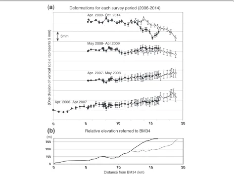
We established leveling routes on the eastern flank of Mount Ontake volcano in 1999 (Fig. 1) in order to detect deformation resulting from seismic swarm activity (Kimata and Miyajima 2001). The first route was extended to Yashikino village in 2002. In order to im-prove the spatial layout of the benchmarks, a branched leveling route was established in 2004 (the Kiso-Onsen route). Together, these routes are 23 km in length and include a total of 60 benchmarks. The cumulative height difference along the leveling routes is ~350 m (Fig. 2b). Benchmarks consist of small brass nails installed on concrete bases at intervals of ~300 m. Precise leveling was conducted using DNA03 (Leica Geosystems) and NA3003 (Leica Geosystems) and SDL1 (Sokkia Topcon) digital levels with bar-coded spear invar leveling rods. Precise leveling surveys were conducted along these routes in April 2006, April 2007, May 2008, April 2009, August 2013, and October 2014 (Fig. 2a). In April 2006, April 2007, and October 2014, all of the routes were measured, while the routes from benchmark BM25 to the west were measured in April 2008 and April 2009. In August 2013, a short distance between benchmarks BM205 and BM310 was measured. Short bridges and tunnels were not surveyed along the level-ing route because of road construction and traffic. De-formation resulting from these points was assumed to
be negligible, because construction covered only short distances (less than 100 m). Survey results prior to 2006 were discussed in Kimata et al. (2004, 2011). De-formation was calculated using benchmarks BM34 (April 2006 and April 2007), BM25 (April 2008, April 2009, and October 2014), and BM205 (August 2013) as reference points.
Leveling survey errors
In general, the error of precise leveling increases with the square of the distance of the observed route. The Geospatial Information Authority of Japan defines the threshold for closure of a round-trip survey as
e¼2:5pffiffiffiS; ð1Þ
where e is the threshold for closure of a round-trip
survey (mm) and S is the distance (km) between two
benchmarks. On this basis, measurements were repeated until the value of closure became smaller than the threshold given by Eq. (1). In most cases, the value of closure was sufficiently smaller than the threshold.
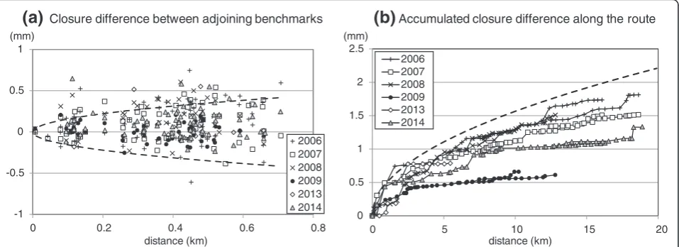
Leveling routes are usually laid out in the form of a loop, in order to check for survey errors. However, we could not adopt a looped leveling route because of road conditions in the mountainous study area. To define the survey error (σ) of a non-loop leveling route, Pelton and Smith (1982) presented the following equation:
σ¼pβffiffijpffiffiffiS; ð2Þ
whereσis the random error of a non-loop leveling route (mm),βis a constant related to accuracy,jis a constant related to the number of measurements (here, j is 2), and S is the distance (km) from the reference bench-mark. From leveling data at the Long Valley Caldera, Vanicek et al. (1980) calculated the value ofβto be 0.7.
We therefore checked the survey error by using the closure difference of the round-trip survey on the Yashikino and Kiso-Onsen routes. The total of all the closure differences was found to be less than 2 mm (Fig. 3). Most of the closure differences were smaller than the curve (82 %) calculated from Eq. (2) using β= 0.7 (Fig. 3).
We also considered the scale error, which is consid-ered to be the main factor involved in systematic
errors from leveling surveys. A significant cause of such errors is the shift in scale due to thermal expan-sion of the leveling rod. However, in our survey, we used spear invar rods to minimize thermal expansion. In addition, we made a correction for thermal expan-sion using the linear expanexpan-sion coefficient of spear invar. We also took temperature measurements at the time of the leveling surveys in order to estimate the correction value. We additionally checked the influ-ence using a case where the linear expansion
coeffi-cient had an uncertainty of 5.0 × 10⁻⁷/°C, where the
temperature difference was 10 °C and where the maximum relative height from benchmark BM34 was approximately 350 m. A scale error of only 1.75 mm was estimated, and this value was considered sufficiently small as to not signifi-cantly affect the results. Therefore, we concluded that the results were accurate enough to detect a deformation of greater than a few millimeters.
0 5 10 15 20
Apr. 2006- Apr.2007
Apr. 2007- May 2008 May 2008- Apr.2009 Apr. 2009- Oct. 2014
Deformations for each survey period (2006-2014)
(One division of vertical scale represents 5 mm)
5mm
Distance from BM34 (km)
0 100 200 300
0 5 10 15 20
Relative elevation referred to BM34 (m)
(a)
(b)
Fig. 2Vertical deformation and route profiles.aVertical deformation (mm) for each survey period, as detected by precise leveling of the Yashikino route (black circles) and the Kiso-Onsen route (white circles), from April 2006 to October 2014. Deformation was calculated using benchmarks BM34 (for data between April 2006 and April 2007) and BM25 (for all other data periods) as references (See Fig. 1 for locations of BM34 and BM25). Eachdivision
Model selection
While a number of models have been proposed to ex-plain the deformation observed in GNSS data from 2006 to 2007, a unified model has not been developed. Based on previous studies and leveling results, we hypothesized that the magma intruded the shallow system from 2006 to 2009 but that the 2014 eruption and aftermath were characterized by deflation. In this study, we considered four models (spherical source, tensile crack, spherical source with tensile crack, and two tensile cracks) as can-didates for the source model.
We began by modeling the period between 2009 and 2014 because the geometry of the 2014 eruptive fissure pro-vided a useful reference for modeling the shallow source during this period. Our leveling data were insufficient to estimate all parameters of the above models because they were acquired only on the eastern flank of the volcano. In particular, it was difficult to determine an exact geometry of the shallow source. Therefore, the location of the spherical source model was assumed to be beneath the center of the 2014 eruptive fissure, while the location, length, and strike angle for the tensile crack model were assumed from the geometry of the eruptive fissure.
For modeling the period between 2006 and 2014, the geometry of a shallow crack and spherical source was
as-sumed to be the same as that of the 2009–2014 models.
For the other models (spherical source with tensile crack, and two tensile cracks), the shallow spherical source or shallow tensile crack assumed the same geometry as in the 2009–2014 models, and all parameters of the deep tensile crack were estimated.
Model parameters were optimized using a genetic algorithm (GA) in order to conform to the deformation observed from 2009 to 2014 and 2006 to 2009. The GA
method employs a random walk, and, unlike the conven-tional Monte Carlo method, it uses a probability rule for searching (Goldberg 1989). The GA method is an effective approach to the volcano deformation modeling (e.g., Irwan et al. 2006). Optimal parameters are selected on the basis of minimizing the fitness function, which is defined as the weighted residual sum of squares. The deformation at each benchmark was calculated using an elevation-modified Mogi model (Fukui et al. 2003; Mogi 1958) and dislocation model (Okada 1992). Details of the GA method were described by Winter et al. (1996).
The four examined models have the trade-off between the goodness-of-fit of the model and the complexity of the model. The goodness for the four examined models
was determined based on Akaike’s information criteria
(AIC; Akaike 1973) calculated as
AIC¼Nln 2π^σ2þ1þ2K; ð3Þ
where N is the total number of benchmarks, K is the
total number of model parameters, and Vobsn and Vcaln are the observed and calculated vertical deformations at the nth benchmark, respectively. The AIC index, where the model with the lowest AIC value is defined as the best solution, can be used for comparisons between models with different numbers of parameters.
Horizontal deformation
In this study, the model was estimated based on vertical deformation; however, horizontal deformation should be also considered. We verified our model, estimated from
0
(a)
Closure difference between adjoining benchmarks(b)
Accumulated closure difference along the route(mm)
distance (km) distance (km)
(mm)
Fig. 3Closure differences in precise leveling on the Yashikino and Kiso-Onsen routes.aClosure differences in precise leveling on the Yashikino and Kiso-Onsen leveling routes. The distribution of the closing errors between adjoining benchmarks from 2006 to 2014 are plotted.Dashed lines
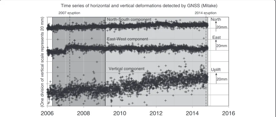
the vertical deformation detected by leveling data, using horizontal deformation detected by GNSS. GSI estab-lished a dense nationwide GNSS network (GEONET), which began its formal operation in 1996. F3 solutions, provided as daily coordinates by GSI, were used in four GEONET benchmarks (Hagiwara, Takane, Mitake, and Outaki) around Mount Ontake volcano (Fig. 1). The Hagiwara benchmark was used as a reference point for the deformation. We selected data for 10 days in April 2006, April 2009, and October 2014 and calculated the deformation from the differences between the 10-day averages. In the period from April 2009 to October 2014, we removed the coseismic offsets resulting from the 2011 M9 Tohoku earthquake and then estimated and removed postseismic deformation using an expo-nential function. Time series of the Mitake GEONET benchmark after removal of the coseismic and postseis-mic effects is shown in Fig. 4. In the vertical component of GNSS (not used here), clear coseismic and postseis-mic deformation could not be confirmed. Horizontal deformation was calculated according to the models esti-mated using the precise leveling data and was compared with the observed deformation detected by GNSS in the periods of April 2006 to April 2009 and April 2009 to October 2014.
Results and discussion
Vertical deformation
From April 2006 to April 2007 (during which time the 2007 phreatic eruption occurred), relative vertical deform-ation between BM34 and BM25 was considered to be negligible (~0.8 mm; Fig. 2); however, on the Yashikino
and Kiso-Onsen routes, ~8 mm of uplift was detected, followed by a smaller amount of uplift between April 2007 and May 2008 (Fig. 2). From May 2008 to April 2009, a minor uplift was detected only on the Yashikino route. To emphasize the uplift before the 2014 eruption, we stacked the 2006–2009 results (Fig. 5b).
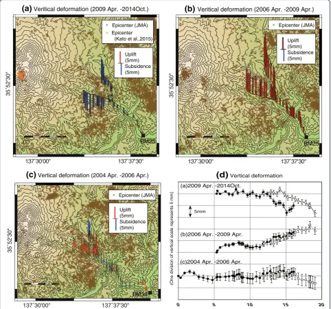
From April 2009 to October 2014, a time period that included the 2014 eruption, ~8 mm of subsidence was detected on the Yashikino and Kiso-Onsen routes (Figs. 2 and 5), with deformation concentrated in the area to the west of BM205. It is notable that the uplift from 2006 to 2009 was larger than the subsidence from 2009 to 2014. Furthermore, the spatial distribution of deformation from 2009 to 2014 and 2006 to 2009 differed from that of previ-ous periods of deformation (Fig. 5c; Kimata et al. 2011).
Pressure source models and pre-eruptive processes before the 2014 eruption
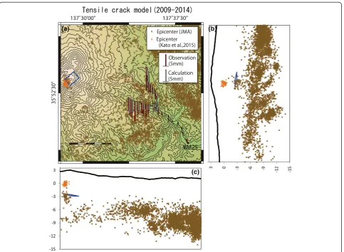
For 2009–2014, optimal parameters for the four models
(spherical source, tensile crack, spherical source with tensile crack, and two tensile cracks) were estimated on the basis of AIC values (Table 1). Among all the candi-dates, the sill-like tensile crack model provided the best fit (Table 2). Although the sill-like tensile crack model was chosen as the best model based on AIC, the differ-ence in AIC number for the tensile crack model and the spherical source model is very small. We consider that our study represents the initial stage of precise leveling survey in the Ontake volcano and that establishing new dense leveling routes to definitely distinguish between the tensile crack model and spherical source model will be needed.
2006 2008 2010 2012 2014 2016
(One division of vertical scale represents 20 mm)
North North-South component
East
Uplift Time series of horizontal and vertical deformations detected by GNSS (Mitake)
East-West component
Vertical component
20mm 20mm 20mm
2007 eruption 2014 eruption
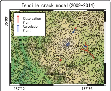
Observed and calculated vertical deformations are shown in Fig. 6, and horizontal deformation based on the sill-like tensile crack model was compared with the deformation detected by GNSS (Fig. 7). Observed horizontal deform-ation was very small (within a few millimeters). From the time series of the Mitake GEONET benchmark, although the deformation trend seems to be changed from inflation to deflation after the 2014 eruption, the amount of change is as small as that of the observation error (Fig. 4). We believe that the locations of GEONET benchmarks were
0 5 10 15 20
(c)2004 Apr. -2006 Apr. (a)2009 Apr. -2014Oct.
(b)2006 Apr. -2009 Apr.
(d)
Vertical deformation(One division of vertical scale represents 5 mm)
Distance from BM34 (km) 5mm
137˚30'00" 137˚37'30"
35˚52'30"
0 5
(c)
Vertical deformation (2004 Apr. -2006 Apr.)Uplift
(a)
Veritical deformation (2009 Apr. -2014Oct.)(b)
Veritical deformation (2006 Apr. -2009 Apr.)Fig. 5Location maps of observed deformation. Location maps of observed deformation for the periodsaApril 2009 to October 2014,bApril 2006 to April 2009, andcApril 2004 to April 2006. Epicenter distributions are denoted bybrown x marks. Redandblue barsdenote uplift and subsidence, respectively.Black squaresdenote reference points of deformation.Error barsdenote the cumulated closing errors from reference points for the deformation in each period.dVertical deformation (mm) during the periods of (a), (b), and (c)
Table 1Akaike’s information criteria (AIC) values for each model (2009–2014)
AIC
Tensile crack model 159.2
Spherical source model 160.7
Two-tensile-crack model 175.2
Table 2Tensile crack model (2009–2014)
Bound interval Grid interval Optimal value Errorsa
Lower Upper
Latitude (degree)b 35.8973
Longitude (degree)b 137.4838
Length (m)b 1000
Strike (degree)b 140
Width (m) 500 5000 500 1500 −300/+550
Depth (m) 0 5000 500 2500 −510/+1100
Dip (degree) 0 −90 1 −15 −15/+6.8
Opening (m) −4.7 −2.6/+1.1
Volume (m3) −7.0 × 10⁶ −3.9 × 10⁶/+1.7 × 106
a
95 % confidence level estimated fromF-tests (Arnadottir and Segall1994) b
Parameters assumed by the approximately linear distribution of volcanic events in 2014
(a) (b)
(c)
too far to detect the deformation of the 2014 eruption. The calculated horizontal deformations were also very small, and differences between the observed and calculated
hori-zontal deformations were within the 3σ error ellipses
(Fig. 7). In addition, the vertical deformation of the Mitake GNSS benchmark was shown uplift for 2009–2014 (Fig. 4). The vertical deformation of the Mitake GNSS benchmark is entirely different from that of our leveling survey. In order to detect clear horizontal deformations, the continu-ous GNSS observation in the summit area will be needed.
The depth of the top of the deflated crack is just beneath precursory activity of VT events (Kato et al. 2015). Yamamoto (2014) reported that thick white fumes and pyroclastic density currents were produced from the 2014 eruptive fissure. GSI (2015) reported that a slight
contraction was detected on the GNSS’s baselines
between both the flanks of Mount Ontake volcano from mid-September 2014 to December 2014. Although the timing of deflation cannot be identified from the leveling data, the deflation of a crack could be caused by the emis-sion of volcanic gases and fluids involving the eruption. VT and LP events might occur by the rising volcanic gases and fluids just above the deflated crack before the eruption. We believe that an increase in magma density was caused by the emission of volcanic volatiles from magma, which was followed by magma drain-back.
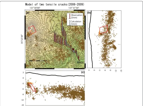
For 2006 to 2009, the two-tensile-crack model provided the best fit based on the AIC values (Tables 3 and 4). Ob-served and calculated vertical deformations are shown in
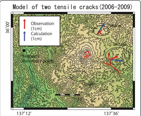
Fig. 8, and horizontal deformation calculated using the two-tensile-crack model was compared with the deform-ation detected by GNSS (Fig. 9). Observed horizontal deformation showed a slight inflation. From the time series of the Mitake GEONET benchmark, the East-West compo-nent was shown a rapid inflation about half year before the 2007 eruption (Fig. 4). The temporal change of the horizon-tal deformation on the Mitake GEONET benchmark seems to be consistent with that of the vertical deformation detected by the leveling survey in the period of 2006 to 2009. Although the observed and calculated vertical de-formations indicated a similar tendency, the horizontal deformation is not fully explained on the basis of the two-tensile-crack model (Fig. 9). Our leveling data, as we have mentioned before, were insufficient to estimate all parameters of the model because they were acquired only on the eastern flank of the volcano. Therefore, several parameters of the model were assumed from the geometry of the eruptive fissure on the surface. We believe that the mismatch between the observation and the calculation is caused by these doubtful assumptions and that establishing new dense leveling routes and GNSS surveys will be needed for the estimation of all model parameters.
The occurrence of a shallow crack was supported by its inferred depth, which overlapped with that of the VT events associated with the 2007 eruption (JMA 2008a). Therefore, the shallow crack may have existed from at least 2006. As a possible objection of the crack model, volume change of the crack may be difficult to continue for a long period from 2006 to 2014 because a crack shape is easy to cool and become solidified. In order to avoid the solidifica-tion of the crack, it may be necessary to supply hot magma continuously from the deeper part and/or to have a thick body of the crack. Within the shallow crack, there is a mismatch between the increasing volume change (0.9 × 10⁶
m3 from 2006 to 2009) and the decreasing volume
change (−7.0 × 10⁶m3from 2009 to 2014). It may be diffi-cult to estimate the accurate volume changes of the two-crack model because of insufficient data in the mountain area. We believe that the increasing volume change is underestimated in our model. On the basis of our results, we believe that a pre-eruptive magma intrusion mainly fed into the shallow crack from 2006 to 2009, representing the main preparatory process of the 2014 eruption.
Fig. 7Horizontal deformation from the tensile crack model. Observed (red arrows) and calculated (blue arrows) horizontal deformations from April 2009 to October 2014 based on the tensile crack model.Error ellipseswere described by 3σ. Theblue rectangledenotes the location of the shrunken tensile crack. The
red linesandblack squaredenote the locations of the leveling routes and the reference point of the global navigation satellite system (GNSS), respectively
Table 3Akaike’s information criteria (AIC) values for each model (2006–2009)
AIC
Tensile crack model 174.9
Spherical source model 178.2
Two-tensile-crack model 155.5
Table 4Two-tensile-crack model (2006–2009)
Bound interval Grid interval
Optimal value
Errors
Lower Upper
Shallow tensile crack Opening (m) 0.6 −1.9/+2.1
Volume (m3) 0.9 × 10⁶ −2.9 × 10⁶/+3.2 × 106
Deep tensile crack Latitude (degree) 35.8689 35.9049 0.0045 35.8869 −0.0126/+0.0293 Longitude (degree) 137.4735 137.4847 0.0056 137.4791 −0.0121/+0.0362
Length (m) 1000 5000 500 2000 −400/+600
Strike (degree) 120 180 1 155 −9/+28
Width (m) 500 8000 500 4500 −800/+1500
Depth (m) 2000 10,000 500 3000 −1300/+5000
Dip (degree) 0 −90 1 −70 −10/+29
Opening (m) 0.7 −0.2/+1.0
Volume (m3) 6.3 × 10⁶ −1.7 × 10⁶/+9.4 × 106
(a) (b)
(c)
From the above discussion, more dense and precise deformation data is prerequisite for detailed discussion. Therefore, we installed new leveling routes on the mountain area in October 2014 and April 2015 (Murase et al. 2015). Based on the improved data, the remaining issues will be performed in future studies.
Based on the GNSS data, MRI and JMA (2007) pro-posed a spherical source at a 0-km depth and a dike at a 2.5-km depth. In contrast, Ishikawa (2008) proposed a model of two dikes at depths of 0 and 4 km. Since the observation period for each model was different, they produced different results. Our preferred model was es-timated using deformation data from the longest period; thus, we believe that our modeling represents a suitable estimate for the stable source. However, deformations from short-lived shallow sources, as detected by MRI and JMA (2007) and Ishikawa (2008), could not be de-tected. The sill-like crack may have existed in a stable configuration in the shallow crust from 2006 to 2014. For this period, all models are consistent with the neces-sary deep dike.
A tensile crack model has already been estimated as a magma source at Mount Asama volcano, Japan (Murakami 2005). A tensile crack with a depth of about 2 km below the surface was estimated by continuous GNSS measure-ments around Mount Asama volcano from 1996 to 2004. Murakami (2005) proposed that buoyant bubble-rich magma surges episodically into the crack-shaped magma reservoir, then it loses the buoyancy through degassing process, and it finally drains back to the further depth. Such activity has a strong resemblance to that occurring at Mount Ontake volcano.
In addition, a spherical source with a depth of about 8 km below the surface was estimated based on the pre-cise leveling surveys in Mount Asama volcano (Murase et al. 2007). The buoyant bubble-rich magma may supply episodically from the deep spherical source to the shal-low tensile crack in Mount Asama volcano. In Mount Ontake volcano, a spherical source with a depth of about 10 km and a shallow dike were estimated based on GNSS in the period from November 2006 to January 2007 (GSI 2008). The magma may supply from the deep spherical source to the shallow tensile cracks in Mount Ontake volcano.
Temporal changes in pre-eruptive processes before the 2014 eruption
Distinct uplift began on the Kiso-Onsen and Yashikino routes in 2006 (Fig. 10a, c) and continued until at least 2009. Although a phreatic eruption occurred in Mount Ontake volcano in March 2007, the magnitude of eruption is really small. We believe that uplift continued after the 2007 eruption because the amount of volcanic gas emitted by the 2007 eruption may be too small to have a loss of the magma’s buoyancy. From 2009 to 2014, the leveling survey was not conducted on the Yashikino route (Fig. 10b), while in August 2013, the leveling survey was conducted only on
a part of the Kiso-Onsen route (BM205–BM310). The
results suggest that the uplift trend continued between April 2009 and August 2013 (Fig. 10a). Therefore, the uplift may continue until at least August 2013, albeit without seis-mic activity at the summit area, after the small eruption event in 2007 (Fig. 10c).
From the results between August 2013 and October 2014, the subsidence occurred after August 2013 (Fig. 10a). We, however, found no evidence to decide the exact occurrence time of subsidence from the leveling result because the leveling surveys were only conducted in August 2013 and October 2014. We believe that the subsidence mainly occurred during the 2014 eruption because the record of the tiltmeter located in about 3 km southeast part of the eruptive fissures suddenly showed a decrease in the slope angle or deflation in the 2014 eruption (JMA 2014).
We compared the temporal changes in vertical deform-ation to baseline change detected by GNSS (Fig. 10e). A rapid expansion of the baseline was detected from December 2006 to March 2007. However, a significant change was not detected from March 2007 to September 2014. On the other hand, a minor inflation of the summit area was detected by the campaign GNSS survey from February 2007 to April 2007 (MRI and JMA 2007). The locations of GEONET benchmarks were too far to detect clear deformation, as the latter was localized to a very small region of the study area. Using campaign GNSS data from February 2007 to April 2007, MRI and JMA (2007) Fig. 9Horizontal deformation from the two-tensile-crack model.
(a)
(b)
(c)
(d)
(e)
proposed a shallow inflation source at a 0.1-km depth. Up-lift was only detected by the leveling survey from 2007 to 2013. This result is particularly important for the under-standing of the preparatory process of the 2014 eruption.
We also briefly addressed deformation along the Yashikino route from 2002 to 2006. It was challenging to consider the preparatory process during the above period using a quantitative approach because deformation was affected by the seismic swarm activity that occurred close to the leveling routes (Fig. 10d). However, minor up-lift can be roughly estimated from 2002 to 2006 (Fig. 10b), suggesting the preparatory process may have initiated prior to 2006.
Possible scenarios of the preparatory process preceding the 2014 eruption
Based on the rapid uplift from 2006 to 2007, magma may have ascend beneath the summit in December 2006, while deep and shallow tensile cracks rapidly expanded from December 2006 to March 2007. VT, LP, and VLP events may have been caused by the rapid expansion of cracks (Fig. 11a; Nakamichi et al. 2009).
Based on the smaller amount of uplift between 2007 and 2009, we inferred that a minor amount of magma was supplied continuously, allowing tensile cracks to slightly expand. The shallow source may have inflated during this period (MRI and JMA 2007). Based on the Kiso-Onsen route time series (Fig. 10a), we believe that this trend continued until August 2013. After the 2007 eruption, a minor inflation of the summit area was detected, not only by the leveling survey but also by the campaign GNSS (MRI and JMA 2007). How-ever, the presence of expanded cracks from 2007 to 2013 had not been inferred until now.
The phreatic eruption occurred on 27 September 2014, and the shallow tensile crack may have deflated at this activity (Fig. 11c). VT and LP events might occur by the rising volcanic gases and fluids just above the deflated crack (Kato et al. 2015). From the leveling result, clear deformation caused by volume change of the deep crack was not detected. The deep crack may not change during this time.
We could not detect what kind of crustal deformation occurred immediately before, during, or after the 2014 phreatic eruption because the leveling surveys were only conducted in August 2013 and October 2014. Based on the continuous GNSS survey, clear deformations were not detected on GEONET benchmarks in the 2014 phreatic eruption because these locations are too far to detect it (Fig. 10e). In order to detect small deformation localized to a very small region around eruptive fissures, continuous GNSS surveys on the mountain area will be needed.
Conclusions
Significant uplift (~10 mm) and subsidence (~8 mm) were detected from 2006 to 2009 and 2009 to 2014, respectively, on the eastern flank of Mount Ontake volcano using pre-cise leveling surveys. The most suitable model to explain the subsidence (2009–2014) was a sill-like tensile crack esti-mated to be−4.7 m in opening, 1.5 km in width, 2.5 km in depth, and dipping at−15°. A two-tensile-crack model best accounts for the uplift between 2006 and 2009. The geom-etry of the shallow crack was assumed to be the same as that of the sill-like tensile crack. The opening of the shallow crack was modeled to be 0.6 m. The deep crack was esti-mated to be 0.7 m in opening, 2 km in length, 4.5 km in width, 3 km in depth, and with a dip of 70°.
Distinct uplift began in 2006 and was followed by seis-mic activity and a small phreatic eruption. This uplift
-9
(a)
Stage One (Preparatory stage) 2006-2007(b)
Stage Two (Preparatory stage)2008-2013
(c)
Stage Three (phreatic eruption stage) 2014
trend may have continued until August 2013; however, after the 2007 event, deformation was aseismic. The up-lift from 2006 to 2013 suggests that magma ascended rapidly beneath the summit area in December 2006 and that deep and shallow tensile cracks expanded between 2006 and 2013. The results suggest that concurrent with the phreatic eruption of 27 September 2014, the shallow crack may have deflated.
The results of this study demonstrate that minor deform-ation detected by highly accurate and dense geodetic obser-vations (e.g., precise leveling surveys) in mountainous areas can provide useful information for understanding prepara-tory activity preceding phreatic eruptions.
Competing interests
All authors declare that they have no competing interests.
Authors’contributions
MM carried out the leveling surveys and analysis of the leveling data and drafted the manuscript. FK designed the leveling routes, carried out the leveling surveys, and helped to draft the manuscript. YY carried out the leveling surveys and helped to draft the manuscript. SH and KM carried out the leveling surveys. TM, HM, and TO carried out the leveling surveys and helped to draft the manuscript. SY, RM, HI, TM, and KU carried out the leveling surveys. KY and HN helped to draft the manuscript. All authors read and approved the final manuscript.
Acknowledgements
We thank two anonymous referees for their careful reading of our manuscript and their numerous constructive suggestions that helped to improve this paper. We would like to thank the staff and students of Nagoya University for their support during the surveys. We gratefully acknowledge the Geospatial Information Authority of Japan for providing the F3 solutions from the GEONET benchmarks. We are also grateful to the Japan Meteorological Agency for providing the hypocenter catalogs. This research was partially supported by JSPS KAKENHI (26900002) and the Collaborative Research Program of Disaster Prevention Research Institute, Kyoto University (27G-03). Some figures were prepared using the generic mapping tools (GMT) package (Wessel and Smith 1995).
Author details
1Department of Geosystem Sciences, College of Humanities and Sciences,
NIHON University, 3-25-40, Sakurajosui, Setagaya-ku, Tokyo 156-8550, Japan.
2Tono Research Institute of Earthquake Science, Association for the
Development of Earthquake Prediction, 1-63, Yamanouchi, Akiyo-cho, Mizunami, Gifu 509-6132, Japan.3Research Center for Seismology,
Volcanology and Disaster Mitigation, Graduate School of Environmental Studies, Nagoya University, D2-2(510), Furo-cho, Chikusa-ku, Nagoya 464-8601, Japan.4Institute of Seismology and Volcanology, Faculty of
Sciences, Kyushu University, 2-5643-29 Shinyama, Shimabara 855-0843, Japan.
5
Institute of Seismology and Volcanology, Graduate School of Science, Hokkaido University, Kita 10 Nishi 8, Kita-ku, Sapporo 060-0810, Japan.6Aso
Volcanological Laboratory, Graduate School of Science, Kyoto University, Kumamoto 869-1404, Japan.7Sakurajima Volcano Research Center, Disaster
Prevention Research Institute, Kyoto University, 1722-19 Sakurajimayokoyama-cho, Kagoshima 891-1419, Japan.
Received: 6 October 2015 Accepted: 13 January 2016 Published: 22 January 2016
References
Akaike H (1973) Information theory and an extension of the maximum likelihood principle. In: Petrov BN, Csaki F (eds) 2nd International Symposium on Information Theory. Akademoai Kiado, Budapest., pp 268–281 Arnadottir T, Segall P (1994) The 1989 Loma Prieta earthquake imaged from
inversion of geodetic data. J Geophys Res Solid Earth 99(B11):21835–21855
Battaglia M, Troise C, Obrizzo F, Pingue F, De Natale G (2006) Evidence for fluid migration as source of deformation at Campi Flegrei caldera (Italy). Geophys Res Lett 33, L01307, http://dx.doi.org/10.1029/2005GL024904
Daita Y, Tanada T, Tanbo T, Ito H, Harada M, Mannen K (2009) Temporal change of the pressure source estimated by tilt records during the 2001 Hakone swarm activity. Bull Volcanol Soc Jpn 54(5):223–234 (In Japanese with English abstract) Fukui K, Sakai T, Yamamoto T, Fujiwara K, Takagi A, Churei M (2003) Availability
and limitations of an elevation-modified Mogi model to estimate the pressure source from volcanic crustal deformation. Paper presented at the Volcanological Society of Japan 2003 Fall Meeting 35
Geospatial Information Authority of Japan (2008) Crustal deformation around Ontake volcano. Report of the Coordinating Committee for Prediction of Volcanic Eruption 96:36–39 (In Japanese)
Geospatial Information Authority of Japan (2015) Ontake volcano. Coordinating Committee for Prediction of Volcanic Eruption (In Japanese)
Goldberg DE (1989) Genetic algorithms in search, optimization, and machine learning. Addison Wesley, Reading, MA, p 401
Irwan M, Kimata F, Fujii N (2006) Time dependent modeling of magma intrusion during the early stage of the 2000 Miyakejima activity. J Volcanol Geoth Res 150:202–212
Ishikawa K (2008) Observation and examination of the crustal deformation around Ontake volcano and Tatun Volcano Group, Taiwan. MS Thesis, Nagoya University., p 37
Japan Meteorological Agency (2008a) Volcanic activity of Ontakesan Volcano—from December 2006 to February 2007. Report of the Coordinating Committee for Prediction of Volcanic Eruption 96:18–35 (In Japanese)
Japan Meteorological Agency (2008b) Volcanic activity of Ontakesan (from March 2007 to June 2007). Report of the Coordinating Committee for Prediction of Volcanic Eruption 97:14–29 (In Japanese)
Japan Meteorological Agency (2014) Volcanic activity of Ontakesan. Coordinating Committee for Prediction of Volcanic Eruption, (In Japanese)
Kato A, Terakawa T, Yamanaka Y, Maeda Y, Horikawa S, Matsuhiro K, Okuda T (2015) Preparatory and precursory processes leading up to the 2014 phreatic eruption of Mount Ontake, Japan. Earth Planets Space 67:111. doi:10.1186/ s40623-015-0288-x
Kimata F, Miyajima R (2001) Ground deformation detected by precise leveling around Ontake earthquake swarm area in September 1999 to April 2000. Bulletin of Tono Earthquake Science Institute 6:91–96 (In Japanese) Kimata F, Miyajima R, Murase M, Irwan M, Darmawan D, Solim D, Ohta Y (2003)
Vertical movements detected by precise leveling at the Ontake earthquake swarm area in the period of 1999–2003: upheaval at Yashikino Area. Bulletin of Tono Earthquake Science Institute 10:69–75 (In Japanese)
Kimata F, Miyajima R, Murase M, Darwaman D, Ito T, Ohata Y, Irwan M, Takano K, Ibrahim F, Koyama E, Tsuji H, Takayama T, Uchida K, Okada J, Solim D, Anderson H (2004) Ground uplift detected by precise leveling in the Ontake earthquake swarm area, central Japan in 2002–2004. Earth Planets Space 12:E45–E48
Kimata F, Miyajima R, Murase M, Ishikawa K (2011) Vertical deformation detected by precise leveling at the earthquake swarm area of eastern Ontake volcano in 2000–2009. Bulletin of Tono Earthquake Science Institute 27:67–72 (In Japanese) Kimura J, Yoshida T (1999) Magma plumbing system beneath Ontake Volcano,
central Japan. Island Arc 8:1–29
Matsumoto A, Kobayashi T (1995) K–Ar age determination of late Quaternary volcanic rocks using the“mass fractionation correction procedure”: application to the Younger Ontake Volcano, central Japan. Chem Geol 125:123–135
Meteorological Research Institute of Japan, Japan Meteorological Agency (2007) Ontake volcano. Coordinating Committee for Prediction of Volcanic Eruption. (In Japanese)
Mogi K (1958) Relations between the eruptions of various volcanoes and the deformation of the ground surface around them. Bull Earthquake Res Inst 36: 99–134
Murakami M (2005) Magma plumbing system of the Asama Volcano inferred from continuous measurements of GPS. Bull Volcanol Soc Japan 50(5):347–361 (In Japanese, with English abstract)
Murase M, Ono K, Ito T, Miyajima R, Mori H, Aoyama H, Ohshima H, Yoshida Y, Terada A, Koyama E, Takeda T, Watanabe H, Kimata F, Fujii N (2007) Time-dependent model for volume changes in pressure sources at Asama volcano, central Japan due to vertical deformations detected by precise leveling during 1902–2005. J Volcanol Geoth Res 164:54–75
Murase M, Kimata F, Miyajima R, Mori H, Yamanaka Y, Horikawa S, Matsuhiro K, Ohkura T, Yoshikawa S, Inoue H, Mishima T, Sonoda T, Matsushima T, Uchida K (2015) Preparatory process for the 2014 eruption in Ontake Volcano estimated from precise leveling (2006–2014). Presented at the Japan Geoscience Union Meeting 2015, SVC45-15
Nagoya University (1999) Temporal variations of seismic activity in the southeastern Ontake volcano (1977–1998). Report of the Coordinating Community for Volcanic Eruption Prediction 74:64–68 (In Japanese) Nakamichi H, Kumagai H, Nakano M, Okubo M, Kimata F, Ito Y, Obara K (2009)
Source mechanism of a very-long-period event at Mt Ontake, central Japan: response of a hydrothermal system to magma intrusion beneath the summit. J Volcanol Geoth Res 187:167–177
Okada Y (1992) Internal deformation due to shear and tensile faults in a half-space. Bull Seism Soc Am 82:1018–1040
Pelton JR, Smith RB (1982) Contemporary vertical surface displacements in Yellowstone National Park. J Geophys Res 87:2745–2761
Sano Y, Nakamura Y, Wakita H, Urabe A, Tominaga T (1984) Helium-3 emission related to volcanic activity. Science 224:150–151
Vanicek P, Castle RO, Balazs EI (1980) Geodetic leveling and its applications. Rev Geophys 18:505–524
Wessel P, Smith WHF (1995) New version of the Generic Mapping Tools released. Trans Am Geophys Union 76:329
Winter G, Periaux J, Galan M, Cuesta P (1996) Genetic algorithms in engineering and computer science. Wiley, 480.
Yamada N, Kobayashi T (1988) Geology of the Ontakesan district. With geological sheet map at 1:50,000. Geol. Surv. Jpn., p 136, In Japanese, with English abstract
Yamamoto T (2014) The pyroclastic density currents generated by the September 27, 2014 phreatic eruption of Ontake Volcano, Japan. Bull Geol Surv Japan 65:117–127
Yamamoto K, Sonoda T, Takayama T, Ichikawa N, Ohkura T, Yoshikawa S, Inoue H, Matsushima T, Uchida K, Nakamoto M (2013) Vertical ground deformation associated with the volcanic activity of Sakurajima Volcano, Japan during 1996–2010 as revealed by repeated precise leveling surveys. Bull Volcanol Soc Japan 58(1):137–151
Submit your manuscript to a
journal and benefi t from:
7Convenient online submission
7Rigorous peer review
7Immediate publication on acceptance
7Open access: articles freely available online
7High visibility within the fi eld
7Retaining the copyright to your article