Environment Friendly Predictive Farming
Using IOT and Cloud Computing
Siddu Srinadh1,M.V.Pavan Kumar2
M.Tech Student, Department of Computer Science and Engineering, Sri Mittapalli College of Engineering,
Tummalapalem, Andhra Pradesh, India
Assistant Professor, Department of Computer Science and Engineering, Sri Mittapalli College of Engineering,
Tummalapalem, Andhra Pradesh, India
ABSTRACT: paper presents Internet of Things (IoT) resolution applied to prognostic Agriculture (PA) it's the aptitude of grouping real-time information on totally different parameters associated with agriculture. The technological advances associated with this activity are of nice importance since agriculture is taken into account associate economic and social pillar essential for the well being of society. Additionally, the growing demand for period info within the agriculture field has driven the event of economical wireless communications via detector networks. Wireless detector Network (WSN) provides low price, low energy consumption, straightforward to implement resolution in places of inauspicious access for the implementation of wired networks. Prognostic agriculture may be thanks to optimizing resources and improve cultivation through the gathering of relevant info through the preparation of detector networks, providing farmers with applied mathematics info to create applicable selections supported reliable information. the current analysis describes the look, implementation and validation method of an IoT victimization WSN technological resolution which may collect info associated with surroundings humidness, Soil Temperature, air pressure, Level of luminance and ultraviolet radiation; this info has relevancy to work out optimum parameters for cultivation and farming strategies.
KEYWORDS: IOT, Cloud Computing, Wireless Sensor Network, Predictive Agriculture, WIFI, MQTT.
I. INTRODUCTION
provides farmers with valuable info geared toward creating higher selections. Many services implement the processes for desegregation advanced info and communications technologies (ICT) [4]. Wireless device Network (WSN) may be a technological resolution a part of associate ICT framework presently being applied in areas associated with medical [5], biotechnology [6], natural disasters [7], health [8], [9], public safety [10], and national defense [11]. WSN technology support farmer activities by optimizing resources, raising the standard of merchandise, making ready the surroundings for agriculture and reducing the prices related to the management of crops. Environmental applications for WSN embrace hearth detection [12], [13], agriculture [14], among others. IoT victimization WSN square measure supported low energy consumption components that square measure ready to collect info, a method such info and transmit it by suggests that of wireless communications to a central process unit known as organizer Node. A WSN rule was developed [15] for cluster head section. Thanks to the characteristics of wireless device networks, its use within the agriculture field may be a valuable technological resolution since it will collect info on completely different parameters with its sensors. The WSN resolution delineates during this paper implements MQTT may be a consumer Server publish/subscribe electronic communication transport protocol. Its lightweight weight, open, simple, and designed thus on is straightforward to implement. These characteristics build it ideal to be used in several things, together with affected environments like for communication in Machine to Machine (M2M) and Internet of Things (IoT) contexts wherever any low code footprint is needed and/or network information measure is at a premium. The protocol runs over TCP/IP, or over alternative network protocols that offer ordered, lossless, bi-directional connections. Its options include:
Use of the publish/subscribe message pattern that provides one-to-many message distribution and decoupling of applications. An electronic communication transport that's agnostic to the content of the payload. Three qualities of service for message delivery: "At most once", wherever messages square measure delivered per the simplest efforts of the operative surroundings. Message loss will occur. This level can be used, as an example, with close device information wherever it doesn't matter if a private reading is lost because the next one is revealed shortly once. "At least once", wherever messages square measure assured to arrive however duplicates will occur. "Exactly once", wherever message square measure assured to arrive specifically once. This level can be used, as an example, with charge systems wherever duplicate or lost messages could lead on to incorrect charges being applied.
Fig. 1. System interconnection diagram
data, it saves all the information in a very remote information wherever all the data are often held on in the cloud (Cayenne) displayed through a Graphic interface to completely different users together with call manufacturers.
Each node is capable of searching the best way to send the information to the Coordinator Node In [16] a region-based static clustering protocol is applied in order to provide an efficient coverage in a defined agricultural area. The sleeping mode feature reduces power consumption and increases battery life. The aforementioned features highlight the reasons why the MQTT protocol represents a robust solution for the implementation of WSN in addition to its simplified network configuration and large frame payloads. The WSN proposed in this paper consists of the following components:
3 main nodes, Coordinator node, Software Management System (SMS) with a Cayenne Cloud plat form. The first node contains luminosity, UV radiation, and pressure sensors; the second node has relative humidity and temperature sensors for both soil and environmental conditions. A third node provides routing functionalities, establishing a mesh network with alternative routes in case of the collapse of any of the aforementioned nodes. The sensor node data reaches the Coordinator Node where it is then stored in a Cayenne Cloud plat form and displayed to the user via a Graphic User Interface (GUI) as shown in Figure 1.
The paper is organized as follows: in section 2, the design of the WSN network is presented. Section 3, describes the user interface. In section 4, the validation test results are presented and discussed. Finally, in section 5, the work is concluded with some remarks.
II. RELATEDWORK
The WSN solution proposed in this paper consists of three nodes, one coordinator node which acts as a gateway and software management systems. A sensor node is comprised by the following hardware components: Sensing unit, Processing Unit, Communication Unit, and Power unit [17].
A. Node Structure :
Node 1 consists of the following components:
• BH1750 light sensor it is a digital light sensor displaying values of measurements in Lux (lumen/m2), which represents the intensity of light per square meter. The sensor has a measuring range from 1 to 65535 Lux, and delivers a digital output in I2C format.
• BMP085 pressure sensor The BMP085 module is a sensor that provides measurements of atmospheric pressure. There are various factors that influence the air such as temperature, humidity and wind pressure. The module presents a great immunity to electromagnetic noise, high accuracy and linearity, an ADC, a temperature sensor (used to compensate for pressure measurements) and a control unit which utilizes an E2PROM memory from which you can include values of compensation to increase the predictive of the measurements made.
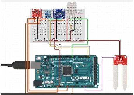
Fig. 2. WSN interconnection diagram
• The Arduino Mega 2560 may be a microcontroller board supported the ATmega2560. it's fifty-four digital input/output pins (of that fourteen will be used as PWM outputs), sixteen analog inputs, four UARTs (hardware serial ports), a sixteen rate oscillator, a USB association, an influence jack, Associate in Nursing ICSP header, and a button. It contains everything required to support the microcontroller; merely connect it to a pc with a USB cable or power it with Associate in Nursing AC-to-DC adapter or battery to induce started. The Mega is compatible with most shields designed for the Arduino and therefore the former boards Duemilanove or Diecimila.
• GPS NEO- half dozen Module belongs to the family of receivers GPS NEO-6, that area unit characterized by its sensible performance. It comes with Associate in Nursing antenna and it doesn't want additional accessories to figure. It provides data like latitude, longitude, date and time.
• Li-ion 18650 Batteries the facility for each of the nodes is given reversible Li-ion 18650 batteries, with a capability of 5000 mA.
Node a pair of contains:
• Soil SHT11 wetness Associate in Nursing temperature sensing element This sensing element carries with it a microcircuit for top prophetical measurements of temperature and ratio, that provides a digital output for simple reading and interpretation, so the obtained measurements area unit quick and proof against external conditions.
• DTH22 it's a digital temperature and wetness sensing element. It uses an electrical phenomenon wetness sensing element and a thermostat to live the encompassing air and displays the info employing a digital signal on the info pin (no analog input pin). it's quite straightforward to use, however, it needs careful synchronization to require knowledge. solely the sole} downside of this sensing element is that you just will only get new knowledge once each a pair of seconds.
B. organizer Node
This node is chargeable for receiving the data from the opposite 3 sensing element nodes, stores {the data|the knowledge the data} during a Cayenne Cloud Platform and displays such information to the tip user via the graphical user interface. Figure a pair of depicts the interconnection options between the UV, Lux, air pressure, Temperature, and wetness sensors and therefore the Arduino Mega microcontroller.
III.USER INTERFACE
CAYENNE CLOUD PLATFORM SYSTEM
Once the program is end, the port connected to the organizer node, and so it starts receiving frames. The sensing element tab presents data on the measurements performed by the sensors within the Cayenne Cloud Platform graphical user interface and is delineated in figure.3. The request for data was created in seven seconds for every node; but, this worth will be changed, taking into consideration the time it takes every sensing element to form As a result, every one of the data of the node is going to be updated every fourteen seconds.
IV.RESULTS
To verify the correct operation of the sensors, several tests were conducted as follows:
UV Radiation : The ML8511 could be a ultraviolet light detector, that is appropriate for getting intensity of ultraviolet light (mW/cm2) inside or outdoors. The ML8511 is provided with indoor electronic equipment that converts photo-current to voltage reckoning on the ultraviolet light intensity. This distinctive feature offers a straightforward interface to external circuits like ADC. Within the power down mode, typical standby current is zero.1 A, therefore facultative an extended battery life.
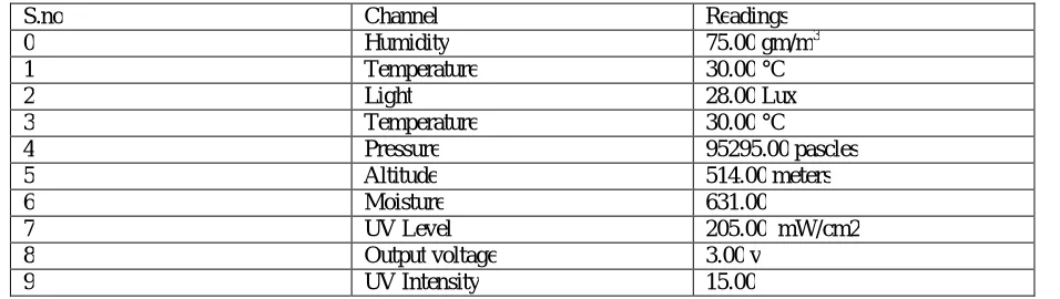
Lu minous intensity : In order to validate the data acquired by the BH1750 Sensor which is integrated in node 1, it is necessary to make a comparison with other calibrated equipment; The measurement unit is expressed in Lux; it should be remembered that the luminous intensity results depends on the intensity, area, and angle of incoming light. The lab 850007 sensor outputs luminous intensity (Iv) data in foot-candle units, so it is necessary to perform the Conversion to Lux (Ev - Illuminance Index) for comparison purposes with the BH1750 sensor; the distance is measured in meters. The conversion formula is as follows: Eυ = Iυ D2 (1) ,Where: Eυ is the illuminance index Iυ is the luminous intensity D is the distance Table 1 shows the results obtained after comparing the lab equipment sensor 850007 and the node sensor BH1750. The variation margin goes up to 6%.
S.no Channel Readings
0 Humidity 75.00 gm/m3
1 Temperature 30.00 °C
2 Light 28.00 Lux
3 Temperature 30.00 °C
4 Pressure 95295.00 pascles
5 Altitude 514.00 meters
6 Moisture 631.00
7 UV Level 205.00 mW/cm2
8 Output voltage 3.00 v
9 UV Intensity 15.00
TABLE I : SENSOR TEST CHARACTERISTICS
Atmospheric pressure: Atmospheric pressure is measured by the BMP085 sensor and the results are delivered in Pascal (Pa) units. At sea level, atmospheric pressure is typically higher; the atmospheric pressure is 101200 Pa. On the other hand, if the altitude increases, atmospheric pressure decreases. In Mount Everest, the atmospheric pressure is 38200 Pa. In this atmospheric pressure typically ranges between 91500.00-95295.00 Pa, The measurements obtained with the BMP085 sensor reflect an atmospheric pressure of 95295.00 Pa; It can be inferred that the sensor is operating properly.
condensation from occurring. The DHT twenty-two device measurements square measure correct. Low price three to 5V power and I/O a pair of.5mA gamma hydroxybutyrate current use throughout conversion (while requesting data) smart for 0-100% wetness readings with 2-5% accuracy smart for -40 to 80°C temperature readings ±0.5°C accuracy No quite zero.5 rate (once each a pair of seconds) Body size fifteen.1mm x 25mm x seven.7mm four pins with zero.1" spacing.
Moisture and soil temperature: Node 2 integrates the SHT11 sensor family of surface mountable relative humidity and temperature sensors. The sensors integrate sensor elements plus signal processing on a tiny foot print and provide a fully calibrated digital output. A unique capacitive sensor element is used for measuring relative humidity while temperature is measured by a band-gap sensor. The applied CMOSens® technology guarantees excellent reliability and long term stability. Both sensors are seamlessly coupled to a 14bit analog to digital converter and a serial interface circuit. This results in superior signal quality, a fast response time and insensitivity to external disturbances (EMC). The node SHT11 sensor is working properly. In terms of the relative soil moisture, it is necessary to perform a technical procedure to determine it as accurately as possible, by applying the following formula: H = Sw – Sd Sd .100 (2) Where: H is the humidity percentage Sw the mass of the wet sample Sd is the mass of the dry sample The water retention capacity is given by the ratio of the mass of the soil saturated with water and mass of the dry soil sample, for this reason it is necessary to carry out the tests with two samples and two iterations each.
V. CONCLUSION
With the implementation of a Wireless Sensor Network with a mesh configuration, information can be transmitted via wireless communications at a range of 100 meters outdoors and 20 meters indoors without loss of data from one node to another; the range can be extended by introducing more nodes configured as routers. The data presented in the GUI to the end user is provided in real-time. The only limitation is given by the time it takes the sensors to perform measurements, and transmit to a Cayenne cloud plat form to store information. The WSN system was implemented to allow the end user to perform statistical analysis on the obtained measurements and derive useful information about environmental conditions. It was verified that the GPS NEO - 6M module has a latency of 12 minutes to acquire information related to the location of the nodes in an indoor setup; this despite the fact that the manufacturer indicates that the sensor takes about 27 seconds before it presents the first measurements. Although the sensor is accurate, it has difficulties to connect with satellites when it is setup indoors, being far more effective in outdoor conditions. To confirm that accuracy of the data obtained by the node 1 and node 2 sensors, it was necessary to compare the results with predictive equipment available in the environmental engineering lab as described in section IV. All the WSN sensors obtained measurements with a minimal difference compared with the reference laboratory sensors with the exception of the SHT11 sensor which presented a 11.25% variation with respect to calibrated laboratory sensor. As a result, it is concluded that the reliability of the results depends on the number of samples taken, requiring a minimum of 10 samples and 10 iterations for different types of soils.
REFERENCES
[1] S. F. Di Gennaro, A. Matese, B. Gioli, P. Toscano, A. Zaldei, A. Palliotti, and L. Genesio, “Multisensor approach to assess vineyard thermal dynamics combining high-resolution unmanned aerial vehicle (UAV) remote sensing and wireless sensor network (WSN) proximal sensing,” Scientia Horticulturae, vol. 221, no. April, pp. 83–87, 2017. [Online]. Available: http://dx.doi.org/10.1016/j.scienta.2017.04.024
[2] I. Mat, M. R. M. Kassim, and A. N. Harun, “Precision agriculture applications using wireless moisture sensor network,” 2015 IEEE 12th Malaysia
International Conference on Communications (MICC), pp. 18–23, 2015. [Online]. Available: http://ieeexplore.ieee.org/document/ 7725400/ [3] L. Zheng, H. Zhang, W. Han, and X. Zhou, “Technologies, applications, and governance in the Internet of Things,” In proceedings of the Internet of things-Global technological and societal trends, pp. 141–175, 2011.
[4] J. Granda Cantuna, S. Solorzano, and J.-M. Clairand, “Noise Pollution Measurement System using Wireless Sensor Network and BAN sensors,” 2017 Fourth International Conference on eDemocracy & eGovernment (ICEDEG), pp. 125–131, 2017. [Online]. Available: http://ieeexplore.ieee.org/document/7962522/
[5] G. Sahitya, N. Balaji, C. Naidu, and S. Abinaya, “Designing a Wireless Sensor Network for Precision Agriculture Using Zigbee,” IEEE 7th International Advance Computing Conference (IACC), pp. 287–291, 2017. [Online]. Available: http://ieeexplore.ieee.org/document/7976803/ [6] M. Qiu, Z. Ming, J. Wang, L. T. Yang, and Y. Xiang, “Enabling Cloud Computing in Emergency Management Systems,” Cloud Computing, IEEE, vol. 1, no. 4, pp. 60–67, 2014.
systems for health monitoring and prognosis,” IEEE Transactionson Systems, Man and Cybernetics Part C: Applications and Reviews, vol. 40, no. 1, pp. 1–12, 2010.
[8] H. Alemdar and C. Ersoy, “Wireless sensor networks for healthcare: A survey,” Computer Networks, vol. 54, no. 15, pp. 2688–2710, 2010. [Online]. Available: http://dx.doi.org/10.1016/j.comnet.2010.05.003
[9] T. D. R¨aty, “Survey on contemporary remote surveillance systems for public safety,” IEEE Transactions on Systems, Man and Cybernetics Part C: Applications and Reviews, vol. 40, no. 5, pp. 493–515, 2010.
[10] I. Bayir, “A glimpse to future commercial spy satellite systems,” RAST 2009 - Proceedings of 4th International Conference on Recent Advances Space Technologies, pp. 370–375, 2009.
[11] P. Ji, C.Wu, Y. Zhang, and H. Chu, “AWireless Sensor Network Routing Protocol for Fire Estimation in Building,” Energy, 2009.
[12] J. Granda Cantu˜na, D. Bastidas, S. Sol´orzano Lescano, and J.-M. Clairand, “Design and Implementation of a Wireless Sensor Network to Detect Forest Fires,” 2017 Fourth International Conference on eDemocracy
& eGovernment (ICEDEG), vol. 2, pp. 15–21, 2017.
[13] Aqeel-Ur-Rehman, A. Z. Abbasi, N. Islam, and Z. A. Shaikh, “A review of wireless sensors and networks’ applications in agriculture,” Computer Standards and Interfaces, vol. 36, no. 2, pp. 263–270, 2014. [Online]. Available: http://dx.doi.org/10.1016/j.csi.2011.03.004
[14] J. Jeromina and K. V. Anusuya, “Energy efficient cluster formation algorithm and sink relocation algorithm for precision agriculture,” Proceedings of 2016 Online International Conference on Green Engineering and Technologies, IC-GET 2016, 2017.
[15] S. Maurya and V. K. Jain, “Energy-Efficient Network Protocol for Precision Agriculture: Using threshold sensitive sensors for optimal performance,” IEEE Consumer Electronics Magazine, vol. 6, no. 3, pp. 42–51, 2017.
[16] A. Chauhan, S. Semwal, and R. Chawhan, “Artificial neural network-based forest fire detection system using wireless sensor network,” in 2013 Annual IEEE India Conference (INDICON), 2013, pp. 1–6. [Online]. Available:
http://ieeexplore.ieee.org/ielx7/6712175/6725842/06725913.pdf?tp={&}arnumber=6725913{&}isnumber=6725842{%}5Cnhttp://ieeexplore.ieee.or g/xpls/abs{ }all.jsp?arnumber=6725913