Result Analysis on Detection of Places Based on
Place Extraction Algorithm using Hidden Markov
Model
Mrs. Shilpa Tuteja1, Mrs. R. B. Talmale2
1
Final Year M. Tech CSE, Tulsiramji Gaikwad Patil College of Engineering & Technology Nagpur 2
HOD of CSE Department Tulsiramji Gaikwad Patil College of Engineering & Technology Nagpur Email: [email protected] ; [email protected]
Abstract –
Research on place extraction has been of interest for the detection of meaningful places that users visit. According to location-based applications interpretations of meaningful places may be different, a universal place extraction algorithm that is able to detect all kinds of meaningful places needs to be
developed. Unfortunately, previously
proposed place extraction algorithms are not able to generate accurate result and also failed to perfectly detect meaningful places. This work proposes a new place extraction algorithm that can significantly enhance the accuracy of place extraction. The basic concept used in system is a hidden markov model. It is model used to find nearest possible location from irrelevant information return from yahoo API. Our algorithm shows remarkable detection accuracy in place extraction, significantly higher than any other previously proposed algorithms. Furthermore, the proposed algorithm can efficiently operate
in mobile environments because its
computations are simple.
I. Introduction
The move from location to place requires
interactions between location sensing
technologies (e.g. GPS or GSM positioning) algorithms that identify places from location
data and applications and services that utilize place information. These interactions can be facilitated using a mobile platform, i.e., an application or framework that runs on a mobile phone. The actual place identification process can be understood as a data analysis task where the goal is to analyze (location) measurements and to identify areas that are meaningful to the user. Mobile devices have fundamentally changed the way people interact with computing devices. Nowadays people are no longer tied to a specific usage situation, but they can use computing services wherever, and whatever they do. In mobile environments, the information needs of the user often depend on the user's situation.
Location also plays a fundamental role in our daily lives. For example, location information is widely used in human communication .The location systems that mobile devices support typically provide location information as a pair of coordinates
(e.g., latitude and longitude).However,
humans do not refer to locations as a pair of coordinates, but using semantic expressions that are imbued with meanings, such as at home or in a library .Thus there is more to location than mere coordinates. The notion of place provides a way to represent location information that is consistent with the way
information. Places are roughly defined as physical locations that are linked with semantically descriptions and meaningful activities. This suggests that place information could be used, e.g., in applications and services that support social interactions. The rest of the paper is organized as follows. Section II surveys related work, Section III system model, Section IV Summary, Section V Conclusion, Section VI Future work, Section VII References.
II.Related Work
In this paper K-means clustering algorithm is used to extract place, a system that automatically clusters GPS data taken over an extended period of time into meaningful locations at multiple scales. These locations are then incorporated into a Markov model that can be consulted for use with a variety of
applications in both single user and
collaborative scenarios [1].
In DJ-Cluster algorithm various methods are available to discover places. It is also defined as a set of essential evaluation metrics and an interactive evaluation framework. K-Means clustering algorithm is used for place discovery with reasonable accuracy.
Partitioning Clustering method is used K-Means clustering algorithm to learn a user’s significant locations from location history data. K-Means clustering algorithm is efficient and iterative. It minimizes an error term which is the sum of the squared distances of each point to its cluster center ,a mean vector. The algorithm initially assigns all points to a predefined number of clusters randomly. Then it iterates through each point, finds the cluster center nearest that point, and assigns the point to the cluster that the center belongs to. This iteration is repeated until the error term is deemed small or not decreasing much[2].The Beacon Print algorithm presented in this paper addresses the problem of automatically learning the places a person takes their mobile device and then being able to recognize whenever the device returns there. Beacon
Print uses 802.11 and GSM response-rate histograms to learn and recognize places using radio fingerprints. Using 802.11 and GSM radios as its sensors it allows Beacon Print to run on commodity hardware, since many mobile devices have these radios built in. Beacon Print helps to recognize a place after the first time the devices go there [3].
This paper helps in diversifying the radii used in the clustering algorithm. These two algorithms have adopted the clustering concept to place extraction, but their detection accuracy was relatively low because they ignored the coordinates’ time information in the clustering process [4].
III. System Model
Two techniques are used to developed system first is hidden markov model and k-means algorithm. After loading original image. First we find metadata from image i.e. we get GPS Position (GPS latitude and longitude) then we pass these GPS Coordinates to yahoo API for more information about places.
Yahoo API generate large amount of data but it may contain information which is irrelevant to the data that we have entered. So to find out the correct and relevant information we have to apply hidden markov model for finding nearest possible location related to that co-ordinate above.By applying hidden markov model we find some important places for user such as school, library, college, temple, hospitals, restaurant etc. After applying hidden markov model we get information related to that image. Using this information next step is to find out important place for user as shown in fig 1.To plot
location on graph k-means clustering
In result analysis first we find metadata from image i.e. we get GPS Position ( GPS latitude and longitude) then we pass these GPS Coordinates to yahoo API for more information about places .yahoo api generate large amount of data but it may contain information which is irrelevant to the data that we have entered. So to find out the correct and relevant information we have to apply hidden markov model for finding nearest possible location related to that co-ordinate above. By applying hidden markov model we find some important places for user such as school, library, college, temple, hospitals, restaurant etc.
Information Extraction Using Hidden Markov Model
Information extraction can be defined as the task of automatically extracting instances of specified classes or relations from text.
Hidden Markov models and related
probabilistic sequence models have been among the most accurate methods for learning information extractors. Most of the work in learning HMMs for information extraction has focused on tasks with semi-structured and other text sources in which English grammar
does not play a key role. After running system we get following result show in snapshot.
Fig 2: Image Selector
In the above snap we upload the path of image and send it to Exif data reader.jar file to extract the metadata from that image to find GPS Position (longitude and latitude).
Fig 3: Retrieved Metadata from Image
The Above snap gives the details idea about
metadata .metadata consist of various
Fig 4 : Retrieved Metadata From Yahoo
API
In above snap GPS coordinate retrieved through metadata passed to yahoo api for finding Related Latitude And Longitude .When you click on Dataset it will generate the list of all possible GPS information.
Fig 5: Retrieved Information after
Applying Hmm
In above snap it shows retrieved information after applying hidden markov model.
Fig 6: Image Related Specific Information
In above snap we get information after applying hmm model but still information retrieve from hmm model is not so clear. So for that we click on specific information button to get the information properly i.e. it show place name, country name, state name, district name, latitude and longitude.
Fig 7: Meaningful Information for User
In above snap to find out meaningful place for user example hotel, school, library, temple, and garden etc. For that you have to enter minimum distance and place name then click on go button. System will generate list of places entered.
In above snap the information extracted from image is shown on map.
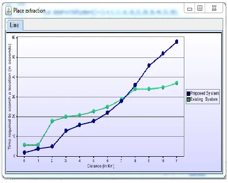
Fig 9: Graph on Place Extraction
IV. Summary
All above snapshot and graph indicates the process of system developed to extract meaningful information through images for that we demonstrated how locations of significance can be automatically learned from gps data at multiple scales. We have also shown a system that can incorporate these locations into a predictive model of the user's movements. In addition, we have described several potential applications of such models. Potentially such methodologies might be extended to other sources of context as well. The graph is giving the exact idea about time required to search location for user.
V.CONCLUSION
For some applications that require place logs, extremely high extraction accuracy may not be needed. However, regardless of the
applications, place extraction algorithm
extracts useful information from the raw location trajectories of the users. As supportive information process, therefore, the place extraction algorithm should provide high extraction accuracy, provide accurate path where the user want to visit.
In our proposed system user enter an image as input; calculate its latitude and longitude provide all possible paths & provide a shortest path from a given location to the destination. Our approach is build on previous work of HMMs and incorporating grammatical knowledge into information-extraction models. In particular, our method take into account that phrases and states must have matching types, and that phrase state must emit complete phrases.
VI. Future Work
In this system we are using a few images restricted to some known places to find the location. It can be further developed to find the places in more wide areas having even more distance than the local places. Again, we can enhance this project by including MUI (Many University Interpretation) while this is
based on Traditional Probabilistic
Interpretation. This will also allow us to search multiple places at the same time and pinpoint the locations of them on the map and then visit them one by one. Also it will help us to determine different locations with similar structures so that it will help the user to differentiate between them and find the exact location of the places.
VII. References
[1] D. Ashbrook and T. Starner, “Using GPS to Learn Significant Locations and Predict Movement across Multiple Users,” Personal Ubiquitous Computing, vol. 7, no. 5, pp. 275-286, Oct. 2003.
[2] C. Zhou, D. Frankowski, P. Ludford, S.
Shekhar, and L. Terveen,“Discovering
Personally Meaningful Places: An Interactive
Clustering Approach,” ACM Trans.
Information Systems, vol. 25, no. 3,article 12, 2007.
Varshavsky, “Identifying Important Places in People’s Lives from Cellular Network Data,” Proc. Ninth Int’l Conf. Pervasive Computing (Pervasive ’11), vol. 6696, pp. 133-151, June 2011.
[4] L. Liao, D. Fox, and H. Kautz, “Extracting Places and Activities from GPS
Traces Using Hierarchical Conditional
Random Fields,” Int’l J. Robotic Research, vol. 26, no. 1, pp. 119-134, Jan. 2007.
[5] K. Zhang, H. Li, K. Torkkola, and M. Gardner, “Adaptive Learning of Semantic Locations and Routes,” Proc. First Int’l Conf. Autonomic Computing Comm. Systems, pp. 3:1-3:10, Oct. 2007.
[6] P. Nurmi and S. Bhattacharya, “Identifying Meaningful Places: The Non-Parametric Way,” Proc. Sixth Int’l Conf. Pervasive Computing (Pervasive ’08), pp. 111-127, May 2008.
[7] P. Nurmi, “Identifying Meaningful Places,” PhD Thesis, Dept. of Computer
Science, Univ. of Helsinki, Finland,
http://urn.fi/URN:ISBN:978-952-10-5790-8, 2009.