ARCHAEOLOGICAL DATA RECOVERY AT 38BU833,
A ST. CATHERINES AND SAVANNAH SHELL MIDDEN SITE,
HILTON HEAD ISLAND, BEAUFORT COUNTY, SOUTH CAROLINA
~~
CHICORA FOUNDATION RESEARCH SERIES 27
~I
II
L~
ARCHAEOLOGICAL DATA RECOVERY AT 38BU833, A ST. CATHERINES AND SAVANNAH SHELL MIDDEN SITE, HILTON HEAD ISLAND, BEAUFORT COUNTY, SOUTH CAROLINA
RESEARCH SERIES 27
Michael Trinkley Debi Hacker Natalie Adams David Lawrence
Chicora Foundation, Inc. PO Box 8664 • 861 Arbutus Drive
Columbia, South Carolina 29202 803/787-6910
March 1992
Library of Congress Cataloguing-in-Publication Data
Archaeological data recovery at 38BU833 : a St. Catherines and Savannah shell midden site, Hilton Head Island, Beaufort County, South Carolina / Michael Trinkley ••• ret al.].
p. cm. -- (Research series / Chicora Foundation, ISSN 0882-2041 ; 27)
"March 1992."
Includes bibliographical references.
1. Skull Creek Site (S.C.) 2. Woodland culture--South Carolina--Hilton Head Island--Antiquities. 3. Hilton Head Island (S.C.)--Antiquities. I. Trinkley, Michael. II. Series: Research sereis
(Chicora Foundation) ; 27. E99.W84A69 1992
975.7'99--dc20 92-6719
The paper used in this publication meets the m~n~mum
requirements of American National Standard for
Information Sciences - Permanence of Paper for Printed Library Materials, ANSI Z39.48-l984 00.
i
Men are not machines • They are men - a tautology which is sometimes worth remembering.
ABSTRACT
This study presents the results of archaeological data recovery at a prehistoric shell midden site on Hilton Head Island (38BU833) by Chicora Foundation in January 1992. Excavation of 900 square feet revealed the presence of intact shell midden deposits, features, and an artifact assemblage incorporating the Deptford, St. Catherines, and Savannah phases. Also present is an eighteenth century low status occupation perhaps reflecting some of the earliest settlement on Hilton Head Island.
The Early Woodland Deptford component was found situated approximately 250 to 300 feet inland from Skull Creek. Although thoroughly disturbed by agricultural activities, the midden appears generally similar to that of the later St. CatherinesjSavannah phase.
The Late Woodland St. Cather ines and Savannah occupation was found adj acent to the marsh, overlooking Skull Creek. Excavations reveal a focal subsistence base, oriented almost exclusively to the collection of oysters. Other shellfish were rare, as were vertebrate fauna and ethnobotanical remains. Ceramics, while present, were not abundant. Other cultural remains were limited to a very small lithic assemblage. The co-occurrence of St. Catherines and Savannah ceramics at 38BU833 supports previous investigations in the region which have found the Late Woodland phases blending into one another, with no clear distinctions.
The historic remains identified at the site appears to represent an isolated structure, probably constructed of wattle and mortar daub. The artifacts are suggestive of a moderately low status household occupied about 1750.
TABLE OF CONTENTS List of Figures List of Tables. • Acknowledgements. Introduction. • • Background Goals Curation • • .' . • v • v .vi • 1 Natural Setting Physiographic Province Climate • • • • • • • • • • • • • • • • • • • • • • . • 5
Geology and Soils Floristics
Historical Overview . • . . • • . • • • . • . . • • • • • • • • • . . • 11 Previous Archaeological Studies
Prehistoric Archaeology
Research Strategy and Methods . . . . • • • • • • • • • • . . . • • . • • • • 19 Introduction
Excavations
Laboratory and Analysis Methods Excavations . . • • . • •
Introduction
Radiocarbon Dating Artifact Analysis
• • • • • . . • • • • • • • • • • • . .22
Shellfish Analysis . • David Lawrence • • • . . • . • . . . . • • . . • . . . . 31 Introduction
The Oysters Summary
Analysis of Subsistence Remains . • . . . • • • • • . • . • • • • • • • • • • 34
Faunal
Ethnobotanical Shellfish Summary
Summary and Synthesis . • • • • • • • . • • • • • . . • • • • • • • • • • • .37 Artifacts
subsistence Settlement
The Future of Middle and Late Woodland Shell Midden Archaeology
Hilton Head Island . . Area of 38BU833 • • • • LIST OF FIGURES • • • • • • • 3 • • • • • • • • 6 Figure 1. 2. 3. 4. 5. 6. 7. 8. 9.
Aerial view of 38BU833 • . . • • • • • . • • • • • • • 10
Table
Woodland Period phases . • • • • •
Site 38BU833 • • • • • • • • • •
View of site 38BU833 • • • • •
70-80R30, east profiles. • • • • .
70-80R30 profiles. . • • • • • • • • • •
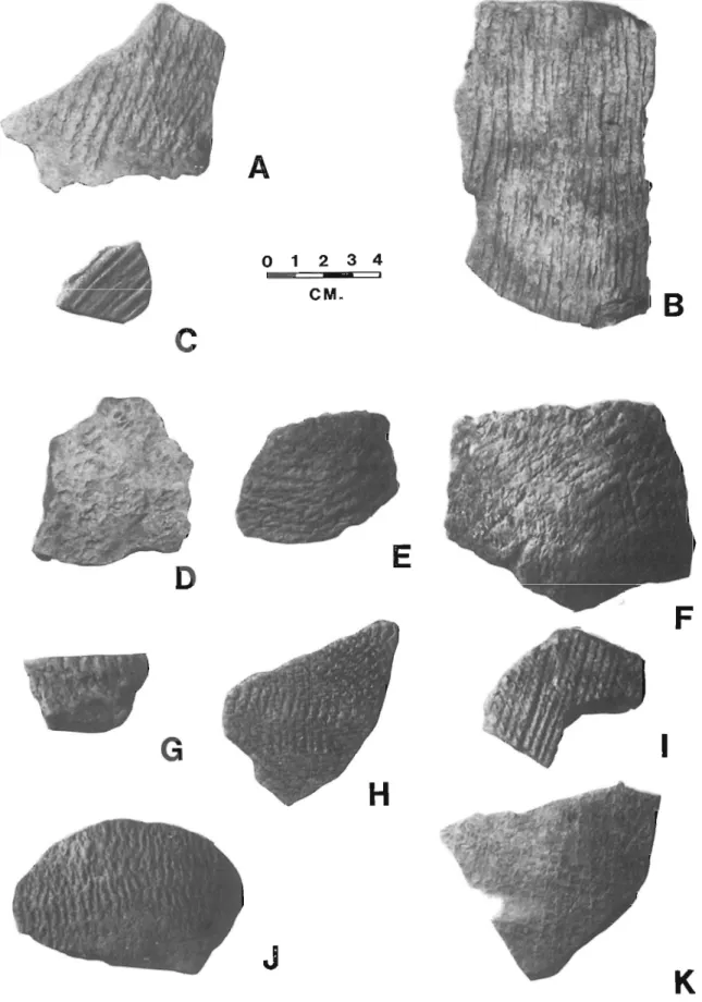
Pottery recovered from 38BU833 •
LIST OF TABLES
1. Recovered Prehistoric Pottery • •
2. Recovered Historic Remains • • • • • • • 3. Pattern Analysis • • • • • . . . • .
4. Mean Ceramic Date. 5. Faunal Remains • . v
...
• • • • • • • • • • 12 • • . • .23 • • • . • • .23 . . • • • .24 • • .24 • • • .26 .28 .29 .29 .29 • • .34ACKNOWLEDGEMENTS
These investigations were conducted through the auspices of The Melrose Company on Hilton Head Island, South Carolina. We wish to particularly thank Mr. Jack Best and Mr. Marty Colleran of The Melrose Company for the administration of the project, as well as Mr. Steve Kiser for his support of our efforts to better understand the prehistory of the Beaufort area.
We also wish to thank the Town of Hilton Head Island, and in particular, Ms. Jill Foster, for assistance in obtaining a permit (Permit Number 92-1) to conduct this research. Assistance in the curation of the collections was provided by Mr. Michael Taylor, Director of the Environmental and Historical Museum of Hilton Head Island. The report has benefitted from the careful and thorough reviews provided by the staff of the South Carolina State Historic Preservation Office, especially Mr. Lee Tippett.
Given the long hours and poor weather, we sincerely wish to thank those who worked with us on this project -- Ms. Mona Grunden and Ms. Liz Pinckney. Obviously, without careful and conscientious excavation, there is nothing worthy of analysis. We would also like to thank Mr. Richard Ellis, Chicora Foundation supporter and volunteer, who not only spend several days with us, but also made us feel welcome in his home.
And finally, we want to thank the numerous individuals who stopped by the site and expressed an interest in the archaeology and history of Hilton Head Island. This concern with the past is, ultimately, the reason that Chicora Foundation and The Melrose Company entered into this partnership. We hope that our efforts have made the past come alive, not only for those who visited us, but also for those who will read this study.
INTRODUCTION Background
Site 38BU833 was originally reported by Chicora Foundation, based on a reconnaissance level survey conducted for the Town of Hilton Head Island
(Trinkley 1987). The site was found to extend along the edge of Skull Creek for at least 800 feet and to extend inland for an undetermined distance. Large portions of the site were damaged by the construction of the Village at Skull Creek project, constructed about 1981. While the boundaries were not well established, i t appeared that the site extended at least as far south as the vicinity of the model condominium. Site 38BU833 recommended as potentially eligible, although insufficient information was generated by the study to document significance.
In accordance with the Coastal Zone Management Act of 1977, the South Carolina Coastal Council, in consultation with the South Carolina State Historic Preservation Officer (S.C. SHPO), stipulated in its permitting process that an archaeological survey of the proposed development incorporating Parcel 4 and 38BU833 should be conducted by The Melrose Company. The purpose of the survey was to identify Geographic Areas of Particular Concern (GAPC) listed on, eligible for, or potentially eligible for listing on the National Register of Historic Places.
This additional survey of the very southern portion of the site was conducted by Chicora Foundation in early 1992 (Adams 1991). Site 38BU833 was found situated along the bank of Skull Creek in the northwestern portion of the survey area. Thirty-two shovel tests were placed at 25 foot intervals in the site area. Fifteen (46.9%) evidenced moderate to heavy shell midden or artifacts, while 10 (31.3%) contained light shell. The remaining 21.8% of the shovel tests were negative. Shell was also found eroding from the creek bank.
While the structure and parking lot (representing the 1981 model condominium built by the Village at Skull Creek) on Parcel 4 destroyed portions of the site, the area between the creek and the building, as well as the area east of the parking lot near the large live oaks, evidenced buried intact shell middens. The site was found to continue about 300 feet inland, east of the creek edge. The central UTM coordinates were established as E524140 N3566850 and the soils are classified as excessively drained Wando fine sands. Soil profiles indicated that the top horizon was generally 0.5 feet in depth, the second zone was generally 0.4 feet thick consisting of shell midden and the same brown sands. subsoil consisted of a tan to yellow sand. Areas immediately around the structure were disturbed, although generally the site was in surprising good condition. Recovered artifacts consisted of two thin curved clear glass fragments, three unidentifiable prehistoric sherds, and one Caraway coastal plain chert projectile point.
The site was recommended eligible for inclusion on the National Register based on the presence of intact midden and probable features. Research questions centered on the continued exploration of Middle and Late Woodland settlement and subsistence systems in the South Carolina low country. This assessment was accepted by the S.C. SHPO. Design considerations revealed that the site could not be green spaced and data recovery excavations were necessary.
Chicora Foundation was requested by the developer's representatives, Mr. Jack Best and Mr. Marty Colleran, to prepare a technical and budget proposal for review and approval by the S.C. SHPO. A proposal for the investigations was
submitted by Chicora on December 20, 1991 and the work was approved by the developer on December 31, 1991. The research design was approved by the s.C. SHPO on January 7, 1992 (memorandum from Mr. Lee Tippett to Dr. Michael Trink1ey).
This property is situated on the northwest edge of Hilton Head Island, bordering Skull Creek to the west, the Village at Skull Creek to the north, Hilton Head Plantation parcels to the east, and the Bay Club to the south. Hilton Head is located about 30 miles from Savannah, Georgia, 90 miles from Charleston, South Carolina, and about 20 miles south of Beaufort (Figure 1).
The proposed development plan for the site involves a number of town house lots. This plan will involve the clearing, grubbing, filling, and paving of the road network; the construction of below ground utilities; and the development of
individual lots. These development activities will result in considerable land
alteration and damage to the archaeological site known to exist on the property. The historical research was previously conducted at the South Carolina Historical Society, the Charleston RMC, the South Caroliniana Library, and the
Beaufort County RMC by Ms. Mona Grunden and Dr. Michael Trinkley during
preparation for archaeological research at adjacent Cotton Hope Plantation (38BU96). The background research specific to this project was conducted by Ms. Natalie Adams at the S.C. Institute of Archaeology and Anthropology on November 13, 1991. The field work at 38BU833 was conducted from January 23, 1992 through January 31, 1992 by a crew of four. The principal investigator for this project
was Dr. Michael Trinkley. The report preparation (including the necessary
laboratory studies) was conducted intermittently from February 3 through February 20, 1992. A management summary was provided on February 4, 1992. A total of 244 person hours were devoted to the field work at 38BU833, while an additional 24 person hours were spent on initial field processing of specimens. All specimens
have been examined for conservation needs and are in the process of being
transported to the curatorial facility.
The survey investigations at 38BU833 found clear evidence of intact shell midden and probable features. One lithic specimen was recovered, although otherwise the artifact density appeared low. The site might easily have been discounted as "small" or "typical" and therefore unworthy of additional
attention. Yet, i t is just the commonness of such sites which gives them
importance.
When similar sites have been investigated (see, for example, Trinkley 1981) they traditionally have been subjected to "typical" archaeological analytical techniques. The results of such studies largely demonstrate that "traditional" archaeological techniques and questions which emphasize the recovery of
diagnostic cultural remains are largely unsuitable for anthropological
reconstructions.
Such sites frequently fail to yield large quantities of pottery, diagnostic lithics, or a large variety of archaeological specimens. The sites may also fail to produce other objects of traditional archaeological investigation and interpretation, such as abundant pits or post holes. While the absence of these features alone can be considered significant clues to the sites' functions, they must be coupled with a more intensive collection and analysis of subsistence remains. Of primary concern should be the collection of reliable subsistence information (including shellfish, ethnobotanical, and faunal remains).
Consequently, the data recovery excavations at 38BU833 attempt to integrate a number of recent recommendations for Woodland Period research developed by Chicora Foundation for the South Carolina Department of Archives and History (see Trinkley 1990:31-37). These include: typological and chronological analyses, subsistence studies, and settlement studies.
Figure 1.
1:, .,
Vicinity of Hilton Head Island, 38BU833. " .' .. : ... . ' .' 7
o
KILO'METERS 4 MILESshowing the location of
The typological and chronological questions involve primarily the St. Catherines and Savannah phases. Although no features were identified which encouraged radiometric dating and charcoal was exceeding sparse, one date was obtained from shell in the Late Woodland midden. While DePratter (1979) has provided useful and accurate information on the temporal periods along this part of the South Carolina coast, much of his synthesis is based on coastal Georgia with little or no independent verification at South Carolina sites. Relatively little research has been conducted on the Middle to Late Woodland pottery typology or ceramics, and research on the nature of the ubiquitous cord marking used as, surface treatment is virtually absent. Consequently, this research was directed at providing a detailed assessment of both paste and cordage. It was hoped that this research, however, tentative, might offer hope for unraveling the confusion surrounding Middle to Late Woodland Period cord marked ceramics. Similar research has been conducted by Chicora Foundation at sites on Spring and Callawassie island (see Trinkley 1991b).
The subsistence question~ involved the seasonality of the remains, the evidence they could provide regarding the habitats exploited and the intensity of that exploitation, and the methods of collecting being used. While determining the importance of each resource to the diet was also recognized as an extremely important research goal, i t was tempered by the recognition that many analytical techniques, such as biomass, diversity, and equitability determination, while relatively easily determined for faunal remains, are very difficult to apply to ethnobotanical and shellfish materials.
In the past Chicora has routinely used ~-inch mesh to screen shell midden soils to improve recovery. At many sites this has been difficult, but well worth the effort, dramatically improving recovery and hence the interpretative potential of the collection. Wing and Quitmyer (1985) have documented the usefulness of small screen size and, more recently, Shaffer (1992) has demonstrated the bias inherent in ~-inch screening.
During this research an effort was made to qualitatively compare several techniques: ~-inch dry screening, ~-inch dry screening, and 1~-inch water screening. The goal was not to offer any startling new conclusions, but to determine if further research at future sites might be appropriate.
Excepting some differences in the screening, efforts were made to consistently collect subsistence materials throughout the site. This included the collection of flotation samples and the use of 2.2 foot square shell columns in middens. In addition, all shell was quantified by weight, and the shell columns were used to provide soil:shell ratios.
The primary settlement question explored during this research.involved the potential to discover intra-site patterning. To this end, both midden and non-midden areas were excavated. While the site exhibited absolutely no evidence of vertical stratigraphy, some evidence of horizontal patterning was observed.
Although historic materials are found in the excavations, no associated features were encountered and no concentrations could be identified. Consequently, while these remains are briefly discussed in this study, they do not represent a major site component.
Curation
The field notes, photographic materials, and artifacts resulting from Chicora Foundation's investigations have been curated at The Environmental and Historical Museum of Hilton Head Island as Accession Number 1992.3. The artifacts from data recovery excavations at 38BU833 have been cataloged as ARCH 3263 through ARCH 3284 (using a lot provenience system). The artifacts have been cleaned and evaluated for conservation needs. All were found to be stable and no treatments were undertaken. All original records and duplicate copies were provided to the curatorial facility on pH neutral, alkaline buffered paper and the photographic materials were processed to archival permanence.
NATURAL SETTING Physiographic Province
Beaufort County is located in the lower Atlantic Coastal Plain of South Carolina and is bounded to the south and southeast by the Atlantic Ocean, to the east by St. Helena Sound, to the north and northeast by the Combahee River, to the west by Jasper and Colleton counties and portions of the New and Broad rivers. The mainland primarily consists of nearly level lowlands and low ridges. Elevations range from about sea level to slightly over 100 feet above mean sea level (MSL) (Mathews et al. 1980:134-135). Hilton Head is located between Port Royal Sound to the north and Daufuskie Island to the south. The island is separated from Daufuskie by Calibogue Sound and from the mainland by a narrow band of tidal marsh and Skull Creek. Between Hilton He.ad and the mainland are several smaller islands, including Pinckney and Jenkins Islands.
Hilton Head is about 11.5 miles in length and has a maximum width of 6.8 miles, incorporating just under 20,000 acres of highland and 2,400 acres of marsh. Elevations range from sea level to 21 feet mean sea level (MSL) at the top of the highest natural beach ridges (Mathews et al. 1980).
Hilton Head is situated in the Sea Island section of South Carolina's Coastal Plain province. The coastal plain consists of the unconsolidated sands, clays, and soft limestones found from the fall line eastward to the Atlantic Ocean, an area of more than 20,000 square miles or about two-thirds of South Carolina (Cooke 1936:1-3). Elevations range from just above sea level on the coast to 600 feet MSL adjacent to the Piedmont province. The coastal plain is drained by three large through-flowing rivers -- the Pee Dee, Santee, and Savannah -- as well as by numerous smaller rivers and streams. On Hilton Head there are two major drainages, Broad Creek which flows almost due west into Calibogue Sound, and Jarvis Creek which empties into Mackay Creek just north of Broad Creek.
From Bull Bay southward, the coast is atypical of the northern coastline. The area is characterized by low-lying, sandy islands bordered by salt marsh. Brown (1975) classes these islands as either Beach Ridge or Transgressive, with the Transgressive barrier islands being straight, thin pockets of sand which are rapidly retreating landward with erosion rates of up to 1600 feet since 1939. The Beach Ridge barrier islands, however, are more common and consist of islands such as Kiawah and Hilton Head. They are characterized by a bulbous updrift (or northern) end.
Kana (1984) discusses the coastal processes which result in the formation of barrier islands, noting that the system includes tidal inlets at each end of the barrier island with the central part of the island tending to be arcuate in shape while the ends tend to be broken. Hilton Head has the typical central bulge caused by sand wrapping around the tidal delta and then depositing midway down the island. Further, the south end has an accreting spit where sand is building out the shoreline. The central part of the island, however, has experienced a 25 year erosion trend averaging 3 to 10 feet a year (Kana 1984:11-12; see also U.S. Army Corps of Engineers 1971). More recent work by Kana et al. (1986) confirms considerable shoreline reorientation.
Hilton Head, however, is also a different shape than most of the other islands since i t has a Pleistocene core with a Holocene beach ridge fringe. To understand the significance of this situation, i t is important to realize that technically the sea islands and the barrier islands are different from a
historical perspective. The classic sea islands of colonial and antebellum fame (such as James, St. Helena, and Sapelo islands) are erosional remnants of coastal sand bodies deposited during the Pleistocene high sea level stands. They are crudely elongate, parallel to the present day shoreline, and rectangular in outline. Their topography is characterized by gentle slopes, poorly defined ridges and swales, and elevations from 5 to 35 feet MSL. Typical barrier islands include Pawleys, Kiawah, and Hunting islands. Some islands, such as Hilton.Head, Daufuskie, and St. Catherines, have an oceanward fringe of beach dune ridges which were constructed during the Holocene high sea level stands (Mathews et ale 1980:65-71; Ziegler 1959). Ziegler (1959:Figure 6) suggests that Hilton Head Island is composed of several sea or erosion remnant islands, joined together by recent Holocene deposits.
Site 38BU833 is situated on the northwestern shore of Hilton Head Island adjacent to Skull Creek (Figure 2). The topography is level, gently sloping inland from a high elevation of about 18 feet MSL overlooking the marsh. Erosion along Skull Creek is complex, associated with both seasonal tides and boat traffic using the Intracoastal waterway.
Climate
During the eighteenth century the Carolina low country was described as a paradise, but by the middle of the century South Carolinians had begun to reappraise their environment, seeing the connection between malaria and the low-lying swamps (Merrens and Terry 1984:548). A proverb current in England was "They who want to die quickly, go to Carolina", and a German visitor told his readers that "Carolina is in the spring a paradise, in the summer a hell, and in
...
---
. .....
.
"
,
,
-r-.>
-~,'.
.
~~\."1
\-j 1000 o 1000 2000 3000 4000 5000 6000 7000 FEET H H Hthe autumn a hospital" (quoted in Merrens and Terry 1984: 549) • The Beaufort climate in the early nineteenth century was described as "one of the healthiest" (Mills 1826:377), although Thomas Chaplin's antebellum journal describing life at nearby Tombee Plantation on St. Helena Island presents an entirely different picture (Rosengarten 1987).
The major climatic controls of the area are the latitude, elevation, distance from the ocean, and location with respect to the average tracks of migratory cyclones. Hilton Head's latitude of about 32°l3'N places i t on the edge of the balmy subtropical climate typical of Florida. As a result, there are relatively short, mild winters and long, warm, humid summers. The large amount of nearby warm ocean water surface produces a marine climate, which tends to moderate both the cold and hot weather. The Appalachian Mountains, about 220 miles to the northwest, block shallow cold air masses from the northwest, moderating them before they reach the sea islands (Landers 1970:2-3; Mathews et al. 1980:46).
Maximum daily temperatures in the summer tend to be near or above 90°F and the minimum daily temperatures tend to be about 68°F. The summer water temperatures average 83°F. The abundant supply of warm, moist and relatively unstable air produces frequent scattered showers and thunderstorms in the summer. Winter has average daily maximum and minimum temperatures of 63°F and 38°F respectively. Precipitation is in the forms of rain associated with fronts and cyclones; snow is uncommon (Janiskee and Bell 1980:1-2).
The average yearly precipitation is 49.4 inches, with 34 inches occurring from April through October, the growing season for most sea island crops. Hilton Head Island has approximately 285 frost free days annually (Janiskee and Bell 1980:1; Landers 1970). This mild climate, as Hilliard (1984:13) notes, is largely responsible for the presence of many southern crops, such as cotton.
It is difficult to evaluate the climate in terms of Native American health. Clearly the seasonal weather would have been attractive, although the location on the edge of Skull Creek would subject occupants to extremely bitter winds during a large part of the winter.
Hilliard also points out that "any description of climate in the South, however brief, would be incomplete without reference" to a meteorological event frequently identified with the region -- the tropical hurricane. Hurricanes occur in the late summer and early fall, the period critical to antebellum cane, cotton, and rice growers. These storms, however, are capricious in occurrence:
[i]n such a case between the dread of pestilence in the city, of common fever in the country, and of an unexpected hurricane on the island, the inhabitants • • • are at the close of every warm season in a painful state of anxiety, not knowing what course to pursue, nor what is best to be done (Ramsay, quoted in Calhoun 1983:2).
The coastal area is a moderately high risk zone for tropical storms, with 169 hurricanes being documented from 1686 to 1972 (0.59 per year) (Mathews et al.1980:56). The last Category 5 hurricane to hit this area was the August 27, 1893 storm which had winds of 120 miles and hour and a storm tide of 17 to 19.5 feet. Over 1000 people in South Carolina were reported killed by this storm (Mathews et al. 1980:55). Other notable historic storms have occurred in 1700, 1752, 1804, 1813, and 1885.
Geology and Soils
The Sea Island coastal region is covered with sands and clays originally derived from the Appalachian Mountains and which are organized into coastal, fluvial, and aeolian deposits. These deposits were transported to the coast during the Quaternary period and were deposited on bedrock of the Mesozoic Era
and Tertiary period. These sedimentary bedrock formations are only occasionally exposed on the coast, although they frequently outcrop along the fall line (Mathews et ale 1980:2). The bedrock in the Beaufort area is below a level of at least 1640 feet (Smith 1933:21).
The Pleistocene sediments are organized into topographically distinct, but
lithologically similar terraces parallel to the coast. The terraces have
elevations ranging from 215 feet down to sea level. These terraces, representing previous sea floors, were apparently formed at high stands of the fluctuating, although falling, Atlantic Ocean and consist chiefly of sand and clay (Cooke
1936; Smith 1933:29). More recently, research by Colquhoun (1969) has refined
the theory of formation processes, suggesting a more complex origin involving both erosional and depositional processes operating during marine transgressions and regression.
Cooke (1936) found that most of Hilton Head is part of the Pamplico terrace and formation, with a sea level about 25 feet above the present sea level.
Colquhoun (1969), however, suggests that Hilton Head is more complex,
representing the Princess Anne and Silver Bluff Pleistocene terraces with corresponding sea levels of from 20 to 3 feet.
Another aspect of Sea Island geology to be considered in these discussions is the fluctuation of sea level during the late Pleistocene and Holocene epochs. Prior to 15,000 B.C. there is evidence that a warming trend resulted in the gradual increase in Pleistocene sea levels (DePratter and Howard 1980). Work by Brooks et ale (1989) clearly indicates that there were a number of fluctuations during the Holocene. Their data suggest that as the first stallings phase sites along the South Carolina coast were occupied about 2100 B.C. the sea level was
about 3.9 feet lower than present. However, by 1600 B.C., when a number of
Thorn's Creek shell rings were occupied, the sea level had fallen to a level of about 7.2 feet lower than present levels. By the end of the Thorn's Creek phase, about 900 B.C., the sea level had risen to a level 2.6 feet lower than present, but over 4.5 feet higher than when the shell rings were first occupied. Quitmyer (1985a) does not believe that the lower sea levels at 2100 B.C. would have greatly altered the estuarine environment, although drops of 10 feet would have reduced available tidal resources.
Data from the nineteenth and twentieth centuries suggest that the level is
continuing to rise. Kurtz and Wagner (1957:8) report a 0.8 foot rise in
Charleston, South Carolina sea levels from 1833 to 1903. Between 1940 and 1950
a sea level rise of 0.34 feet was again recorded at Charleston. These data,
however, do not distinguish between sea level rise and land surface submergence. Within the Sea Islands section of South Carolina the soils are Holocene and Pleistocene in age and were formed from materials that were deposited during the various stages of coastal submergence. The formation of soils in the study area is affected by this parent material (primarily sands and clays), the temperate climate, the various soil organisms, topography, and time.
The mainland soils are Pleistocene in age and tend to have more distinct horizon development and diversity than the younger soils of the Sea Islands. Sandy to loamy soils predominate in the level to gently sloping mainland areas. The island soils are less diverse and less well developed, frequently lacking a well-defined B horizon. Organic matter is low and the soils tend to be acidic. The Holocene deposits typical of barrier islands and found as a fringe on some sea islands, consist almost entirely of quartz sand which exhibits little organic matter. Tidal marsh soils are Holocene in age and consist of fine sands, clay,
and organic matter deposited over older Pleistocene sands. The soils are
frequently covered by up to 2 feet of salt water during high tide. These organic
soils usually have two distinct layers. The top few inches are subject to
aeration as well as leaching and therefore are a dark brown color. The lower levels, however, consist of reduced compounds resulting from decomposition of
organic compounds and are black. The pH of these marsh soils is neutral to slightly alkaline (Mathews et al. 1980:39-44). Historically, marsh. soils have been used as compost or fertilizer for a variety of crops, including cotton (Hammond 1884:510) and Allston mentions that the sandy soil of the coastal region, "bears well the admixture of salt and marsh mud with the compost"
(Allston 1854:13).
There are three main soil associations on Hilton Head. The Wando-Seabrook-Seewee association consists of excessively well drained to somewhat poorly drained sands found on the interior. The Fripp-Baratari association consists of excessively drained and poorly drained sands found along the Atlantic shore of the island. The Bohicket-Capers-Handsboro association consists of very poorly drained mineral and organic marsh soils (stuck 1980).
The soils in the immediate vicinity of 38BU833 consist of excessively drained, rapidly permeable Wando Series soils that formed in thick sandy Coastal Plain sediment (Stuck 1980:Map 93).
Floristics
Hilton Head today exhibits four major ecosystems: the coastal marine ecosystem where land has unobstructed access to the ocean, the maritime ecosystem which consists of the upland forest area of the island, the estuarine ecosystem of deep water tidal habitats, and the palustrine ecosystem which consists of essentially fresh water, non-tidal wetlands (Sandifer et al. 1980:7-9).
Mathews et al. (1980) suggest that the most significant ecosystem on Hilton Head is the maritime forest community. This maritime ecosystem is defined most simply as all upland areas located on barrier islands, limited on the ocean side by tidal marshes. On sea islands the distinction between the maritime forest community and an upland ecosystem (essentially found on the mainland) becomes blurred. Sandifer et al. (1980:108-109) define four subsystems, including the sand spits and bars, dunes, transition shrub, and maritime forest. Of these, only the maritime forest subsystem is likely to have been significant to either the prehistoric or historic occupants and only i t will be further discussed. While this subsystem is frequently characterized by the dominance of live oak and the presence of salt spray, these are less noticeable· on the sea islands than they are on the narrower barrier islands (Sandifer et al. 1980:120).
The barrier islands may contain communities of oak-pine, oak-palmetto-pine, oak-magnolia, palmetto, or low oak woods. The sea islands, being more mesic or xeric, tend to evidence old field communities, pine-mixed hardwoods communities, pine forest communities, or mixed hardwood communities (Sandifer et al. 1980:120-121,437).
Several areas of Hilton Head evidence upland mesic hardwood communities, also known as "oak-hickory forests" (Braun 1950). These forests contain significant quantities of mockernut hickories as well as pignut hickory. Other areas are more likely to be classified as Braun's (1950:284-289) pine or pine-oak forest. Wenger (1968) notes that the presence of loblolly and short leaf pines is common on coastal plain sites where they are a significant sub-climax aspect of the plant succession toward a hardwood climax. Longleaf pine forests were likewise a common sight (Croker 1979).
Along Skull Creek, i t is likely that the highland vegetation was dominated by the Oak-Hickory Forest, although land use patterns in the historic period quickly changed the vegetation of the area through settlement and cultivation. A 1981 oblique aerial photograph (Figure 3) shows the site area in early stages of development -- the main Hilton Head Plantation road is paved, the Village at Skull Creek community dock has been built, and the cultivated field have just been converted to pine, but the areas of hardwood vegetation along the edge of Skull Creek are still intact, as are several small "islands" in the cultivated
fields.
The estuarine ecosystem in the Hilton Head vicinity includes those areas of deep-water tidal habitats and adjacent tidal wetlands. Salinity may range from 0.5 ppt at the head of an estuary to 30 ppt where it comes in contact with the
ocean. Estuarine systems are influenced by ocean tides, precipitation, fresh
water runoff from the upland areas, evaporation, and wind. The tidal range for Hilton Head Island is 6.6 to 7.8 feet, indicative of an area swept by moderately strong tidal currents. The system may be subdivided into two major components: subtidal and intertidal (Sandifer et al. 1980:158-159). These estuarine systems
are extremely important to our understanding of both prehistoric and historic
occupation because they naturally contain such high biomass (Thompson 1972:9).
The estuarine area contributes vascular flora used for basket making, as well as mammals, birds, fish (over 107 species), and shellfish.
The last environment to be briefly discussed is the freshwater palustrine ecosystem, which includes all wetland systems, such as swamps, bays, savannas,
pocosins and creeks, where the salinities measure less than 0.5 ppt. The
palustrine ecosystem is diverse, although not well studied (Sandifer et al.
1980:295). A number of forest types are found in the palustrine areas which
attract a variety of terrestrial mammals. On Hilton Head the typical vegetation
consists of red maple, swamp tupelo, sweet gum, red bay, cypress, and various
hollies. Also found are wading birds and reptiles. It seems likely that these freshwater environs were of particular importance to the prehistoric occupants, but probably of limited importance to historic occupants (who tended to describe them in the nineteenth century as "impenetrable swamps").
HISTORICAL OVERVIEW Previous Archaeological Studies
Hilton Head's prehistoric resources have received surprising little detailed archaeological attention. The earliest record of archaeological investigations at a prehistoric site on the island was perhaps Antonio Waring's excavations at the Sea Pines Shell Ring (38BU7) in the 1950s. Allen Calmes made modest collections made from Ford's Skull Creek Shell Ring (38BU8) and the Sea Pines Shell Ring sites in the late 1960s (Calmes 1967a, 1967b). Regrettably, no notes, photographs, or other field documentation survive from these investigations and the collections are, consequently, of little interpretative value.
In 1973 Stanley South conducted a four day project at the Indian Springs site (38BU24) on Hilton Head. Work at the site was limited to the excavation of a 2-foot wide trench bisecting the site north-south and east-west, with each axis a total of 100 feet in length. This work revealed 83 features, including both prehistoric pits, post holes, and a possible palisade line, as well as historic pits. The Indian Springs site, however, was destroyed by development activities before any additional research was conducted.
A 1982 study was conducted by Larry Lepionka in the vicinity of the Village at Skull Creek (Lepionka 1982). Although a copy of the report could not be immediately located, i t seems that i t failed to identify 38BU833.
Work at the Fish Haul site (38BU805) identified a major non-shell Stallings phase site dating from about 1700 to 1300 B. C. was conducted by Chicora Foundation in 1986 (Trinkley 1986). Work identified a Stallings phase structure, pits, a large assemblage of Stallings phase artifacts, and extensive subsistence information. In 1987 Chicora Foundation conducted a reconnaissance level survey of portions of Hilton Head Island for the Town (Trinkley 1987). This work identified a variety of previously unreported prehistoric sites spanning the period from about 2000 B.C. through A.D. 1400.
Work elsewhere in the vicinity, such as that on Pinckney Island (Trinkley 1981) and on Spring and Callawassie islands (Brooks et ale 1982; Trinkley 1991b), provides excellent comparative data.
The Callawassie work explored broad questions of artifactual remains, subsistence, and settlement (Trinkley 1991b). Greater variability in the paste of Deptford wares was found than in any of the following series. There is some evidence, however, that the variation originally seen on an intrasite basis during the Early Woodland, was slowly transformed to variation on an inter-site basis by the Late Woodland. The examination of cordage found that exclusively simple twisted cordage was used. The Z or left twist was consistently more common that the R or right twist and a soft twist was generally more popular than a hard twist. The cordage diameter seems to consistently fall within a range of 0.5 to 4.0 mm.
The radiocarbon dates taken from the sites found considerable overlap between the various typological entities. Deptford materials were found as late as A.D. 930, overlapping with the earliest St. Catherines date of A.D. 750, while the St. Catherines phase may continue to at least A.D. 1385, into the period often associated with Savannah.
Lithics are uncommon throughout these phases. Those identified tend to 11
1000 500 AD 0 BC ... ~ 500 1000 \500 2000
Georgia and Soutbern Soutb Carolina Coast
I
St. CatherinesI'
I
WillingtonI
DeptfordI
Central and Nortbern Soutb Carolina Coast
Santee/ McClellanville Hanover Kount Pleasant!
I
II
Deptford/Deep Creek.I
RefugeI
, I
rhol' 8 Creek I Stallings I \Georgia and Western South Carolina Piedaont
Napier
I
Svift Creek, Deptford/ Cartersville DunlapFigure 4. Woodland Period phases in the south Carolina locality.
Horth Carolina and Eastern South Carolina Piedlont
I
Uwbarrie II
I
Yadkin BadinI
Appalachian SUlit Connestee,
I
PigeonI
Svannanoareflect the use of locally available resources and evidence primarily re-working of existing tools. The Callawassie and Spring Island materials suggested the use of Roanoke Large Triangular points by the St. Catherines and Savannah peoples. The results of subsistence studies suggested that the sites were occupied during the spring and summer, perhaps extending into the fall. The work revealed a diffuse subsistence base, with some indication of increasing focus on fish resources through time. Plant foods, while probably used, are poorly represented in these collections. Shellfish are not only the most noticeable feature of these sites, but also appear to have made the greatest contribution to the diet in terms of biomass.
Prehistoric Archaeology
The Woodland Period archaeology of the coastal area of South Carolina recently has been summarized and briefly synthesized by Trinkley (1990) and there is no need to provide extensive detail in this study (see Figure 4). DePratter (1979) should also be examined for additional background on the ceramic typology of the region, while Brooks et al. (1982) provides a detailed discussion of the excavations at the Callawassie Island Burial Mound. The work of Wilson (1982) will also assist in placing the Middle Woodland burial mound tradition in a better regional framework. It is necessary, however, to briefly discuss the major Middle and Late Woodland phases which have been identified in the work on
-Callawassie and Spring islands.
The Deptford culture takes its name from the type site located east of Savannah, Georgia, which was excavated in the mid-1930s (Caldwell 1943:12-16). Deptford phase sites are best recognized by the presence of fine to course sandy paste pottery with a check stamped surface treatment. This pottery is typically in the form of a cylindrical vessel with a conoidal base. The flat bottomed bowl with tetrapodal supports found at Deptford sites along the Florida Gulf coast (Milanich and Fairbanks 1980:79) is very rare in South Carolina. Other Deptford phase pottery styles include cord marking, simple stamping, a complicated stamping which resembles early Swift Creek, and a geometric stamping which consists of a series of carved triangles or diamonds with interior dots (see Anderson et al. 1982:277-293; DePratter 1979).
The Deptford technology is little better known than that of the preceding Refuge phase, which may provide the antecedent (Peterson 1971:328; cf. Milanich 1971). Shell tools are uncommon, bone tools are "extremely rare" (Milanich and Fairbanks 1980:77), and stone tools are uncommon on Coastal Zone sites. All of this indicates to some researchers that "wood must have been worked into a variety of tool types" (Milanich and Fairbanks 1980:75). One type of stone tool associated with South Carolina Deptford sites is a very small, stemmed projectile point tentatively described as "Deptford Stemmed" (Trinkley 1980b:20-23). This point is the culmination of the Savannah River Stemmed reduction seen in the Thorn's Creek and Refuge phases. Similar points have been found at a variety of Deptford sites (see Milanich 1971:175-176; Stoltman 1974:115-116, Figure 20i-j, 40h-j) • Also found at Deptford sites are "medium-sized triangular points," probably similar to the Yadkin Triangular point (Coe 1964:45, 47, 49; Milanich and Fairbanks 1980:75-76). In the Savannah River area Sassaman et al. (1989:156-157) report that Deptford pottery appears much more strongly associated with triangular projectile points (Badin and Yadkin types) than with the small stemmed points. They note, "small stemmed bifaces are attributed to the Early Woodland period with the recognition that they probably persisted into the subsequent period but were rapidly and thoroughly replaced by triangular forms by 2000 B.P."
(Sassaman et al. 1989:157).
Perhaps of even greater interest is the co-occurrence of the larger
triangular points (such as Badin and Yadkin) with smaller triangular forms (such as Caraway or Roanoke) traditionally attributed to the Late Woodland and South
Appalachian Mississippian periods. This situation has been reported at Coastal Plain sites (Blanton et al. 1986:107), Savannah River sites (Sassaman et a1. 1989:157), and Coastal Zone sites (Trinkley 1990b). Blanton et al. (1986) suggest that these point types were used at the same time, but perhaps for different tasks.
Milanich (1971:Figure 12) illustrates a generalized distribution of this series, which is divided into the Gulf and Atlantic subregions. This distribution, however, should extend to the South Carolina Fall Line and probably as far north as the Neuse River in North Carolina. Anderson (1975:186) has found Deptford wares distributed throughout the South Carolina Coastal Plain, with major sites at the mouths of the Santee and Savannah Rivers. The earliest date for Deptford, 1045±110 B.C. (UGA-35l5), has been obtained from 38LX5 in Lexington County (Trinkley 1980b:11). The most recent date comes from St. Simons Island, Georgia, where a date of A.D. 935±70 (UM-673) was obtained. Milanich and Fairbanks (1980:60) suggest a tighter range of about 500 B.C. to A.D. 600, while Anderson et al. (1982:281) suggest a date range of about 800 B.C. to A.D. 500.
Deptford sites on the South Carolina coast are usually small, especially when compared to the earlier Thom's Creek middens, and they are usually multicomponent. Deptford Coastal Zone sites, while containing shell, do not represent massive mounds, but rather thin middens formed as series of small shell heaps which have been deposited adjacent to the marsh and gradually formed continuous masses. These heaps were the result of short periods of site use, perhaps as a base camp for shellfish collecting (see Milanich and Fairbanks 1980:72-73; Trinkley 1981). Results of soil chemical analyses from the Pinckney Island midden (Trinkley 1981:53-54) suggest less than intensive occupation. The chemical studies support Milanich's assessment that occupation was not on the shell piles, but adjacent to them (Milanich and Fairbanks 1980:72-73; Trinkley 1981:53-54).
Milanich (1971:192-198; see also Milanich and Fairbanks 1980:70-73) suggests that the Deptford phase settlement pattern involves both coastal (i.e., Coastal Zone) and inland (i.e., Coastal Plain) sites. The coastal sites, which are always situated adjacent to tidal creek marshes, evidence a diffuse subsistence system'. The inland sites are also small, lack shell, and are situated on the edge of swamp terraces. This situation is similar to that found in South Carolina, although there are Deptford middens which exhibit a very focal subsistence emphasis (Trinkley 1990b). Sites such as Pinckney Island (38BU67 and 38BU168; Trinkley 1981) and Minim Island (38GE46; Drucker and Jackson 1984; Espenshade and Brockington 1989) evidence large Coastal Zone Deptford occupations, while sites such as 38BU747 (Trinkley 1990b) evidence only small, focal shell midden occupations. Sites such as 38BK984 (Roberts and Caballero 1988) provide evidence of Coastal Plain non-shell midden Deptford occupation.
At Pinckney Island the bulk of the calories came from shellfish while mammals played a relatively insignificant role (Trinkley 1981:57-60). A similar situation occurs at Minim Island, where late spring and summer occupation is documented with a reliance on fishing, with mammals being a secondary, if not minor food source. In the fall there is evidence of intensive oyster gathering and possible use of nearby hickory masts (Drucker and Jackson 1984; Espenshade and Brockington 1989).
Inland, sites such as 38AK228-W, 38LX5, 38RD60, and 38BM40 indicate the presence of an extensive Deptford occupation on the Fall Line and the Coastal Plain, although sandy, acidic soils preclude statements on the subsistence base (Anderson 1979; Ryan 1972; Trinkley 1978, 1980b). These interior or upland Deptford sites, however, are strongly associated with the swamp terrace edge, and this environment is productive not only in nut masts, but also in large mammals such as deer. Perhaps the best data concerning Deptford "base camps" comes from the Lewis-West site (38AK228-W), where evidence of abundant food remains, storage pit features, elaborate material culture, mortuary behavior, and craft
specialization has been reported (Sassaman et ale 1989:96-98).
Milanich observes that "this dual distribution suggests a transhumant subsistence pattern," with inland sites occupied in the fall for the collection of floral resources and the hunting of deer (Milanich 1971: 194; Milanich and Fairbanks 1980:72). While such a subsistence round may have been practiced, i t cannot be documented from the available evidence. Some sites, such as Pinckney Island, were clearly occupied in the iate winter (Trinkley 1981:60). Minim Island, however, was apparently occupied in the summer (Drucker and Jackson 1984), although a fall or winter occupation cannot be precluded. 38BU747 was likewise occupied during the spring and summer (Trinkley 1990b).
A similar situation is observed along the Savannah drainage, where Stoltman (1974:237) observed both floodplain and upland Deptford sites. This duality, according to Stoltman, is "indicative of a gradually increasing dependence upon upland wild plant food" and eventually horticulture (Stoltman 1974: 237), although no archaeological evidence supports this speculation. Hanson (1982:21-23) sees settlement locations becoming more diverse as population pressures require that new food sources be identified and exploited. While this is similar to the explanation offered by Stoltman, Hanson does not imply or suggest that the alternate food source must be horticultural. .
This view of an estuarine Deptford adaptation with minor interior occupations must be re-evaluated based on the Savannah River drainage work of Brooks and Hanson (1987) and Sassaman et ale (1989:293-295) who suggest larger residential base camps and foraging zones along the Savannah River, coupled with smaller, household residences and foraging zones in the uplands along small tributaries. While i t is not yet clear if these upland sites represent a perennial settlement pattern or a seasonal fissioning typical of the Late Archaic, i t seems likely that the pattern was equally affected by demographic pressures and external socio-political influences (see Sassaman et ale 1989:303-304). Of considerable potential significance is evidence of trade between coastal and interior Deptford groups. For example, the Lewis-West site (38AK228-W) has produced evidence of sharks' teeth and whelk shells from the coastal region.
Although the Deptford phase is discussed as· part of the Early
Woodland, many authors place the phase intermediate between the Early and Middle Woodland (see, for example, Anderson et ale 1982:28, 250). Such an approach is not unreasonable, because Deptford exhibits considerable temporal range and cultural adaptations which are more characteristically Middle Woodland (see also Anderson 1985: 53). The Deptford phase, however, is still part of the early carved paddle stamped tradition which is replaced by the posited northern intrusion of wrapped paddle stamping during the Middle Woodland.
The Middle Woodland in South Carolina is characterized by a pattern of settlement mobility and short-term occupation. On the southern coast i t is ·
associated with the Wilmington phase, while on the northern coast i t is recognized by the presence of Hanover, MCClellanville or Santee, and Mount Pleasant assemblages. Wilmington and Hanover may be viewed as regional varieties of the same ceramic tradition. The pottery is characterized almost solely by its crushed sherd temper which makes up 30 to 40% of the paste and which ranges in size from 3 to 10 mm. Wilmington was first described by Caldwell and Waring (Williams 1968:113-116) from coastal Georgia work, while the Hanover description was offered by South (1960), based on a survey of the Southeastern coast of North Carolina (with incursions into South Carolina). The Wilmington phase was seen by Waring (Williams 1968:221) as intrusive from the Carolina coast, but there is considerable evidence for the inclusion of Deptford traits in the Wilmington series. For example, Caldwell and McCann (1940:n.p.) noted that, "the Wilmington complex proper contains all of the main kinds of decoration which occur in the Deptford complex with the probable exception of Deptford Linear Checkstamped" (see also Anderson et ale 1982:275). Consequently, surface treatments of cord marking, check stamping, simple stamping, and fabric impressing may be found with
sherd tempered paste.
Sherd tempered Wilmington and Hanover wares are found from at least the Chowan River in North Carolina southward onto the Georgia coast. Anderson (1975: 187) has found the Hanover series evenly distributed over the Coastal Plain of South Carolina, although i t appears slightly more abundant north of the Edisto River. The heartland may be along the inner Coastal Plain north of the Cape Fear River in North Carolina. Radiocarbon dates for Wilmington and Hanover range from
135±85 B.C. (UM-1916) from site 38BK134 to A.D. 1120±100 (GX-2284) from a
"Wilmington House" at the Charles Towne Landing site, 38CHl. Most dates, however, cluster from A.D. 400 to 900; some researchers prefer a date range of about 200 B.C. to A.D. 500 (Anderson et ale 1982:276).
The best data concerning Middle Woodland Coastal Zone assemblages comes from Phelps' (1983:32-33) work in North Carolina. Associated items include a small variety of the Roanoke Large Triangular points (Coe 1964: 110-111), sandstone abraders, shell pendants, polished stone gorgets, celts, and woven marsh mats. Significantly, both primary inhumations and cremations are known from the Mount Pleasant phase. Phelps notes that:
[a] distinctive cultural feature of Middle Woodland age in the South Coastal region is the rather extensive distribution of low, sand
burial mounds • • The high frequency of secondary cremation,
platform pipes, and other objects in the mounds, and the fact that
at least some of them seem to be placed away from their
contemporaneous habitation sites, points to southern influence during this period (Phelps 1983:35).
Phelps goes on to note that, "[t]heir known spatial extent is limited . • • , and no comparable structures have been reported from • . • South Carolina • •
Further research is needed to determine relationships [of North
Carolina mounds] with . . . those on the Georgia coast" (Phelps 1983:35). Sand burial mounds have been known from the Georgia and southern South Carolina Coastal Zone since C.B. Moore's investigations in 1898. Recent studies include those by the American Museum of Natural History on St. Catherines Island, Georgia, which document the Early to Late Woodland use of sand burial mounds (Larsen and Thomas 1982; Thomas and Larsen 1979), as well as the re-investigation
of the Callawassie Island burial mound (38BU19) in Beaufort County, South
Carolina (Brooks et ale 1982). The presumed burial mound gap between southern coastal South Carolina and southeastern coastal North Carolina has been filled by the 1983 excavations of the Buck Hall site in Charleston County (38CH644) where Trinkley and Zierden were able to determine that the low sand mounds were covering poorly preserved secondary burials (Trinkley 1991a). Rathbun has also identified an ossuary (38HR36) from Horry county, South Carolina (see Conner 1985; Hyman 1983).
Consequently, i t appears that both ossuaries and sand mounds are found along the entire South Carolina coast, although precise dating and thorough understanding of their cultural significance has yet to be achieved. As Wilson
notes, "the sand burial mounds cannot be associated with anyone
prehistoric physical type or aboriginal group," for in North Carolina they are found in the context of probable Iroquoian, Siouan, and Algonquin populations
(Wilson 1982:172). The available information, however, suggests a relatively
egalitarian society was common to all. Anderson suggests that, "these
mound/ossuary complexes appear to represent principal burial areas for local lineages or other currently unrecognized social entities" (Anderson 1985:56).
These Middle Woodland Coastal Plain and Coastal Zone phases continue the Early Woodland Deptford pattern of mobility. While sites are found all along the coast and inland to the Fall Line, shell midden sites evidence sparse shell and artifacts. Gone are the abundant shell tools, worked bone items, and clay balls.
Recent investigations at Coastal Zone sites such as 38BU747 and 38BU1214, however, have provided some evidence of worked bone and shell items at Deptford phase middens (see Trinkley 1990b, 1991b).
In terms of settlement patterns, several researchers have offered some conclusions based on localized data. Michie (1980:80), for example, correlates rising sea levels with the extension of Middle Woodland shell middens further up the Port Royal estuary. Scurry and Brooks (1980:75-78) find the Middle Woodland site patterning in the Wando River affected not only by the sea level fluctuations, but also by soil types (see also Trinkley 1980a:445-446). They suggest that the strong soil correlation is the result of upland sites having functioned as extraction areas, principally for exploitation of acorns, hickory nuts, and deer. Shell midden sites, they suggest, also represent seasonal camps and therefore exhibit small size, low artifact density, and infrequent re-occupation.
In many respects the South Carolina Late Woodland may be characterized as a continuation of previous Middle Woodland cultural assemblages. While outside the Carolinas there were major cultural changes, such as the continued development and elaboration of agriculture, the Carolina groups settled into a lifeway not appreciably different from that observed for the previous 500 to 700 years (cf. Sassaman et al. 1989:14-15). This situation would remain unchanged until the development of the South Appalachian Mississippian complex (see Ferguson 1971).
The Late Woodland on the extreme southern South Carolina Coastal Zone is characterized by the St. Catherines phase, first defined by Caldwell (1971) based on his St. Catherines Island, Georgia work. St. Catherines ceramics are characterized by fine clay tempering (obviously finer than the preceding Wilmington sherd temper) and by carefully smoothed or burnished interiors. Surface treatments include fine cord marked, burnished plain, and net impressed (DePratter 1979:119, 131-132), although sparse quantities of fabric impressed pottery are also observed from South Carolina (Trinkley 1981:82) and Georgia (Larsen and Thomas 1982:304-305). Caldwell viewed the St. Catherines pottery as a refinement of the Wilmington tradition of sherd tempering (Caldwell 1971:91), and sand burial mounds continue to be a significant aspect of the assemblage
(Brooks et al. 1982; Larsen and Thomas 1982; Trinkley 1981:90-92).
While a number of St. Catherines burial mounds have been studied, only one midden area, Victoria Bluff (38BU347), in Beaufort County, has been even briefly tested (Trinkley 1981:73-78). At this site the economy was based on shellfish collection and there is substantial evidence of a winter-early spring occupation. There is, as yet, no documentation of a seasonal round, although some large st. Catherines sites have been found which suggest at least semi-permanent villages
(Trinkley 1990b, 1991b).
The st. Catherines pottery, previously given a terminal date of about A.D. 1150 by DePratter (1979:111), probably dates into the fourteenth century, based on the Victoria Bluff (38BU347) and Pinckney Island (38BU67, 38BU168) work where dates of A.D. 1380±75 (UGA-3516) and A.D. 1535±65 (UGA-3514) were obtained (Trinkley 1981). The tenacity of this simple lifestyle suggests that the effects of the Gaule intrusion was relatively minor in many ways, or they at least co-existed with the native inhabitants whose lives were generally unchanged.
There is only somewhat vague and tantalizing evidence of agriculture or the use of domesticated plants during this period in South Carolina. Investigations at 38AN8 have yielded carbonized gourd rind, as well as a very small sample of squash and corn pollen (see Wood 1986:106). Agriculture, however, cannot be documented in any meaningful way until the rise of the South Appalachian Mississippian period, either in the Piedmont or on the coast.
The Savannah phase is traditionally accepted as the beginning of the South 17
Appalachian Mississippian along the Georgia and South Carolina coasts. The phase was defined by Caldwell and McCann (1941) from the work at the Irene Mound site in Georgia, although the Savannah ware was earlier described by Caldwell and Waring (1939). Dates of about A.D. 1150 to 1300 have been suggested by DePratter (1979:111), although Anderson et al. (1982:308) would extend the date range to about A.D. 1400.
The diagnostic feature of this· phase is the pottery, which is characterized by a fine sand to clay or silt paste with carefully smoothed interiors. Surface treatments include complicated stamped, check stamped, cord marked, and burnished plain. The pottery usually can be distinguished from the later Irene types by the abundant sand or grit in the latter. Although the Savannah pottery tends to be dominated by a variety of concentric circle stamp motifs, filfot, quartered-circle, and split diamond patterns are also found. Anderson et al. (1982: 309) correctly note that the Savannah motifs grade into the following Irene/Pee Dee designs.
Both Caldwell and McCann (1941) and Cook (1966) provide some general information on the nature of coastal Savannah sites, although these studies have examined rather large sites with associated mounds and burials. The work by Larsen and Thomas (1982) at Marys Mound and Johns Mound on St. Catheripes Island are of considerable interest since they document the presence of both St. Catherines and Savannah wares in the same stratigraphic context.
No Savannah period sites have been excavated in the Beaufort area, although Anderson notes that "classic Savannah Complicated Stamped pottery appears to be progressively uncommon to the northeast of the Savannah" (Anderson et al. 1982:311). The Savannah Check Stamped and Cord Marked types, while occasionally present as minority types, appear to also decline in frequency from Savannah northward to Charleston, South Carolina.
It is within this broad context of archaeological knowledge, speculation, and questions that the investigation of 38BU833 on Hilton Head Island was undertaken. The resulting research has offered some considerably new, and hopefully fresh, interpretations of the Woodland period along the southern South Carolina coast.