_____________________________________________________________________________________________________
*Corresponding author: E-mail: [email protected];
International
22(1): 1-15, 2019; Article no.JGEESI.49574 ISSN: 2454-7352
Measuring Hazard Vulnerability by Bank Erosion of
the Ganga River in Malda District Using PAR Model
Rubia Biswas
1*and A. K. M. Anwaruzzaman
11
Department of Geography, Aliah University, Kolkata-14, India.
Authors’ contributions
This work was carried out in collaboration between both authors. Author RB designed the study, performed the statistical analysis, wrote the protocol and wrote the first draft of the manuscript. Author AKMA managed the analyses of the study and the literature searches. Both authors read and approved the final manuscript.
Article Information
DOI: 10.9734/JGEESI/2019/v22i130136 Editor(s): (1) Dr. Suvendu Roy, Assistant Professor, Department of Geography, Kalipada Ghosh Tarai Mahavidyalaya, India. Reviewers: (1) Yongchun Zhu, Shenyang Normal University, China.
(2)Michael Adejare Adegboye, Federal College of Land Resources Technology, Nigeria.
Complete Peer review History:http://www.sdiarticle3.com/review-history/49574
Received 28 March 2019 Accepted 13 June 2019 Published 21 June 2019
ABSTRACT
River banks are characterised by dynamic environments that change in response to a variety of inputs. Bank erosion ordinarily means losses of bank materials and individual particles or aggregates by fluvial, sub-aerial and geo-tectonic processes. It is a common phenomenon of geomorphic hazard associated with flood plains and meandering or braided river system. The problem of bank erosion and shifting of the course of the river Ganga in certain C.D. blocks of Malda District is not purely an environment-related problem but a unique combination of both environment and ‘development’ project. The objective of the present paper is to measure the vulnerability of the villages that are situated adjacent to the Ganga River. Data was obtained from both primary as well as secondary sources. The primary data was collected through observation method and through informal interviews with the affected people. Secondary information was obtained from various research works encountered during the study. The study was framed on the lines of Pressure and Release (PAR) model developed by Wisner, Blaikie, Cannon and Davis (1994 & 2003). The inhabitants of these villages are facing serious problems related to employment, health, education, sanitation, drinking water supply and market due to the river bank erosion. In
some areas people suffer from the irony of dual citizenship. No remedial measures are seriously taken by concerned authorities to solve this problem. Thus, it is incumbent on the part of the government and NGOs to devise corrective mechanism to curb the threat to the existence of the affected people as well as to improve their quality of life.
Keywords: Vulnerability; hazards; river bank erosion; pressure and release mode; socio-economic problem.
1. INTRODUCTION
The word ‘vulnerability’ originated from the Latin root ‘vulnerare’, which meaning ‘to wound’ or in a broader perspective to be susceptible to any physical attack with the incapability to defend [1]. The concept of vulnerability originated in the 1970’s in the field of social sciences from the view point of disaster risk. Vulnerability is the degree of loss to an element or set of elements from any natural or man-made phenomena. Dow [2] enunciated that Vulnerability is the differential capacity of groups and individuals to deal with hazards, based on their positions within physical and social worlds. According to Blaikie (1994), vulnerability as the characteristics of a person or a group in terms of their capacity to anticipate, copes with, resist and recover from impacts of a hazard [1]. The concept of vulnerability implies some risk associated with the physical, social and economic liability and the ability to cope up with the resulting event. It has been defined as the degree to which a system or part of a system, may react adversely during the occurrence of a hazardous event [3]. So, it can be incidental that vulnerability is the community’s capacity to cope up with the undesirable effects of a disaster to prevent potential damage. Vulnerability differs from place to place and with changing nature and severity of hazard. It can be categorized into physical, social and economic vulnerability. Physical vulnerability includes who and what may be damaged or destroyed by any natural or
manmade hazard and socio-economic
vulnerability is the extent to which a population is affected by a hazard [1]. By vulnerability means actually “the characteristics of a person or group and their situation that influence their capacity to anticipate, copes with, resists and recover from the impact of a natural hazard (an extreme natural event or process)” [4]. It involves a combination of factors that determine the degree to which someone’s life, livelihood, property and other assets are put at risk by a discrete and identifiable event (or series or ‘cascade’ of such events) in nature and in society.
According to O’Neil [5] hazard by itself is not a disaster unless there are vulnerable populations
who do not have the capacity to absorb it and who are unable to cope with it. It is the social, cultural, economic and political environment that has made some people more vulnerable to disaster and displacement. In reference to natural hazards, vulnerability cans simply be defined as being exposed to natural hazards with insufficient coping capacity to overcome their
impacts. Riverbank erosion is generally
considered more dangerous than floods. Floods are short term events but bank erosion of river is a long term event lasting impact is examined. It turns ‘prince’ of a time into a ‘pauper’ overnight. It is one of the main causes of disasters that creates havoc to the life and property of the people living in the riverside areas [6].
1.1 Review of Literature
socio-demographic, economic and political conditions are influenced to a large extent due to the bank erosion of the Brahmaputra River. After the erosion, displacement is an immediate impact of such type of disasters. As a result, the resident of such areas face different problems like as identity crisis, risk of poverty, lack of education, improper health care, tendency of criminal activities and so on.
1.2 Objective
The study is aimed at achieving the objective of measuring hazard vulnerability by bank erosion
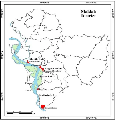
of the Ganga River of four selected C.D. blocks (Manikchak, English Bazar, Kaliachak II and Kaliachak III) in Malda District using PAR (Pressure and Release) model.
2. METHODOLOGY
Data used in the present study are obtained from both primary as well as secondary sources. The primary data was collected through observation method and through informal interviews of the affected people. Secondary sources of data and information are obtained from District Human Development Report (DHDR, 2016), Census
Fig. 1. Location of the study area
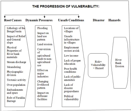
Fig. 2. Pressure and Release (PAR) Model: The progression of vulnerability to the river bank erosion in Malda District (Wisner, Blaikie, Cannon, & Davis, 2003, p. 50)
University of Texas map series no. U502, NG 45-15 (Prepared by the Army Map Service (RMS&H), Crops of Engineers, U. S. Army, Washington, D. C. Compiled in 1955 from: Survey of India 1924-26)
report (DCHB, 2001 and 2011), different occasional papers, articles and various local & national newspapers. Even the secondary information has been enhancement by various research works encountered during the study and also with the help of related books and magazines. Google Earth and satellite images have been used to show the changing variation of the river bank. The study was framed on the lines of Pressure and Release (PAR) model developed by Wisner, Blaikie, Cannon and Davis (1994 &2003). The PAR model delineates disaster as a product of physical exposure and socio-economic pressure (development). The model distinguishes between three components on the social side: root causes, dynamic pressures and unsafe conditions and one component on the natural side, the natural
hazards themselves. This model has been used to study the progression of vulnerability to erosion hazards in the riverine villages.
2.1 Study Area
The geographical extension of this district is from 25º32'80'' N to 24º40'20'' N latitude and 88º28'10''E to 87º45'50''E longitude with an area of 3733 sq. km. Malda district consists of two
sub-divisions, fifteen blocks and two
On the basis of topography and drainage pattern, the district can physiographically be divided into Barind region (eastern part of Mahananda River) and Tal (Western part of Mahananda River). Whereas the area south of the Mahananda is a very fertile land and is known as Diara. Majority of the population of the district depends on agriculture and other allied industry. Malda district is a low-lying plain, through which flow a number of rivers. Major rivers are the Ganga, Mahananda, Fulahar, Kalindri and Tangon all of them are in eastward motion. This district is highly flood and erosion prone. A large no of people of this area are put to hardship to such flood and erosion.
2.2 The PAR Model
The Pressure and Release model (PAR model) is a simple tool for showing how disasters occur when natural hazards affect vulnerable people. The vulnerability is rooted in social processes and underlying causes which may ultimately be quite remote from the disaster event itself. The basis for the PAR idea is that a disaster is the intersection of two opposing forces: those processes generating vulnerability on one side and the natural hazard event on the other. The ‘release’ idea is incorporated to conceptualise the reduction of disaster: to relieve the pressure, vulnerability has to be reduced [4].
Thus, the model concerns itself with identifying the conditions that make exposure unsafe leading to the construction of vulnerability and the causes that create these conditions.
3. RESULT AND DISCUSSION
3.1 Root Causes
The lithology of the Bengal basin is mainly very loose, less compact and has lower consolidation of Holocene sediments [10]. The Ganga is one of the most important rivers of this basin. The physical structure of both sides of the river Ganga is different. The left bank is composed of loose and alluvium components, whereas the right bank is mostly composed of hard rocks because of the presence of Rajmahal Hills. Consequently, unlike the right bank which has more resistive power against the river current, the left bank of the river Ganga has low shear resistance capability. Therefore, the left side of the river bank is more prone to erosion.
3.1.2 Impact of relief and general slope
Physiographic gradient of the Malda district is from north-west to south-east and the general slope is not more than 2º. The contour values at the Farakka Barrage have been found ranging between 15-28 m according to SOI sheets, 1971 (highest elevation is 39.7 m which is located in the middle portion of the district). There is a gap of 2.0 to 2.5m between downstream and upstream of Farakka Barrage. This situation forms curves in the river because of which there is a high concentration of water at one place beyond the required time near the channel [10]. This delay in water flow force the river to erode the eastern bank of the river and on the other bank (the Jharkhand side) alluviation is operative. This trend is continued almost every year on both sides of the river Ganga.
3.1.3 Physical properties of river bank materials
Characteristics of soil such as its physical, chemical properties (particle size distribution, root content etc.) and management practice (crop management and land management) affect the soil erodibility and determine the nature and magnitude of soil erosion. Bank erosion is related to the erodibility of the bank material. Soil texture is an important physical character of soil. Textural classes of the selected zone are 7-8 per cent sandy, 15-16 per cent sandy loam, 45-47 per cent loam, 13-56 per cent clay loam, 11-12 per cent silt loam and 5-6 per cent clay [10]. When a river bank consists of high amount of sand and less amount of clay, the bank material is less cohesive and more susceptible to bank erosion. Thus, the entire bank line starting from Manikchak to Farakka is affected by heavy attacks of erosion due to its unconsolidated and loose constituent materials [11].
3.1.4 Stream discharge
the same time, the heavy discharge of water forcefully hits the river banks and accelerates the disbanding of the bank material and creation of large caves in the river bank. Consequently, the recession of high volume water forces along the bank of river to collapse due to the imbalanced pressure.
3.1.5 Meandering and radius of meander curve of the channel
Meandering is most pronounced in those regions which are characterized by even surface, gentle slope, alluvial deposits and sufficient stream discharge. Radius of meander curves plays a vital role both in erosion as well as in bank line shifting. If the meander bend is sharper and the radius of curvature is smaller, it escalates erosion of the river bank. Furthermore, in case if the meander bend is wider and the radius of curvature is bigger, it aggravates massive erosion of the river bank.
The southern portion of Manikchak block and north eastern part of Kaliachak II block are affected by the continuous erosion due to the wider meander bends and bigger radius of curvature of the main stream of Ganga (Fig. 3).
3.1.6 Role of physiographic division
Physiographically, the district is divided mainly into three regions - Barind, Diara and Tal. The Barind region is made up of ancient alluvial humps with slightly high altitude. The Tal is mostly composed of bog lands formed in many
marshy pockets around vestigial inland
drainages. Remaining, the Diara is a relatively well drained flatland formed by the alluvial deposition of newer alluvium in the transitional zone between the upland and the marshy Tal track. This region consists of Manikchak, Kaliachak I, II & III and English Bazar blocks within the district. The Diara is mostly affected by floods and riverine erosion because of its physiographic formation and proximity to the river Ganga (Fig.3).
3.1.7 Tectonic activity and channel movement
When the river enters Bengal and it suddenly gets confined on both sides. The right bank is bordered by the outliers of the Rajmahal hills and the left bank is bound by the old alluvium of the Barind tract. Geological Survey of India1shows that two major faults run nearly parallel to the Ganga River, the Rajmahal Fault along the right bank and Malda–Kishanganj Fault along the left
bank; these two faults have forced the river to flow in a relatively narrow valley for 80 km long stretch [12]. As Rennell (1788) wrote that ‘Gour, the ancient capital of Bengal, stood on the old bank of Ganges: although its ruins are 4 or 5 miles from the present bank’ [13]. Prof. R. K.
Mukherjee (1938), the famous historian,
mentioned in his book named ‘The Changing Face of Bengal’ that leaving the hills of Rajmahal, Ganges seemed to have passed northwards through the modern Kalindri and then southwards in the lower course of Mahananda, east of the ruins of ancient Gour. According to Hirst (1916), the Ganga shifted due to tectonic activity and mainly by 1515AD earthquake. Singh and Singh(1989) state seven earthquakes of moderate size have occurred around Farakka and adjoining regions in between the year of 1594 and 1975 which suggests that the area is neo-tectonically active [11,12].
3.1.8 Changing trend of population
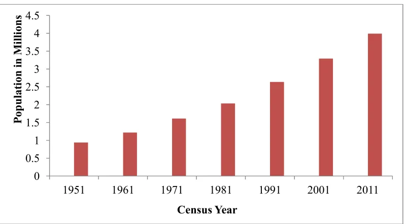
The Ganga River between Sahibganj district of Jharkhand state and Nawabganj district of Rajsahi state in Bangladesh area shows abrupt change in its course. After independence, a large-scale of migration from East Pakistan to the Indian side coupled with unplanned expansion of habitation along the banks of Ganga increased the bank erosion problems many fold. The Diara region encompasses 1,152.3 sq. km (32.16 per cent) areas which includes almost 22.3 per cent settlement and 42.81 per cent population of the district [14]. Many people of Bind community from neighbouring states of Jharkhand and Bihar have settled at Par-Anantapur village of Kaliachak III block for their livelihood and survival.
Now a days, local people of neighbouring district (Murshidabad) flee to the Malda district due to the sever bank erosion by the Ganga that resulting to the over population of the district [15].
3.1.9 Role of embankments and spurs
creates a water head pressure of the river especially in the rainy season. Therefore, the natural way of the river is disturbed by the artificial or man-made constructions which further leads to the shifting nature of the river. The comparative analysis of Toposheet maps (72 O/16) and the satellite images3 reveal that the shifting of the Ganga in the Diara region area has accelerated probability for the anthropogenic activities.
3.1.10 Role of the Farakka barrage
The construction of Farakka barrage was aimed at obstructing the huge water discharge coming
from downstream of the river Ganga. P.K. Parua (2002) former chief Engineer of the Farakka Barrage project has noted: “The construction of the barrage has disturbed the apparent equilibrium condition and the river started to
adjust this huge human interference by
aggradations and degradation of its bed and channel pattern by erosion and siltation. In post Farakka barrage condition the normal sediment transport system has been intercepted due to controlled operation of the barrage gates. The riverbed on the upstream started aggrading with the change of erosion/deposition pattern of river bed and banks” [11,16].
Fig. 3. Physiographic division of Malda district
Fig. 4. Trend of population growth in Malda district (1951-2011)
3.2 Dynamic Pressure
3.2.1 Flooding
Historical records reveal that flood is an important incident over a period of time in this district and it is mainly due to the nature of river. Before 1950s, the interval period of flood recurrence ranged from 4-13 years but after 1971s, the frequency of flood has intensified as it revisits almost every alternate year. In the year of 1998, water level in the Ganga rose to a record high level of 25.40 m [13].Residents of the areas (particularly riverside villages of Manikchak, English Bazar and Kaliachak C.D. blocks) had to migrate due to the flood. Inputs derived from the survey conducted in these areas show that out of hundred households sample nearly 45 HHs of Khaskol Chandipur, 32 HHs of Gopalpur, 23 HHs of Narayanpur and 52 HHs of Palgachhi villages have shifted in the nearest embankment and school building for shelter and livelihood.
3.2.2 Impact on land use pattern
Flood, river shifting, riverbank erosion and soil erosion have directly affected the land-use pattern in the study area. In Manikchak, Kaliachak II and Kaliachak III C.D. blocks, riverbank erosion and seasonal flooding are the common phenomena in the southern and western part of these areas.
These hazardous factors have virtually engulfed the agricultural land and in due course of time
also transformed these lands into a fellow land or sand bar.
3.2.3 Land erosion
The official records about the land erosion of the district are available since 1931s. It is observed that 14335 hectares of fertile land has eroded from the left bank of the river between the years 1931 to 1978 in addition to 4247 hectares or
above 200 sq. km of fertile land which had been swept away during the periods of 1979 to
2004 and almost equal extent of char has emerged along the opposite bank of the river [17].
3.2.4 Conversion of agricultural lands to non-agricultural use
Besides the loss of cropland to the river bank erosion, the economic livelihoods of certain vulnerable sections of the rural population in Malda district have come under tremendous pressure due to the diversion of lands that formerly supported field crops into other non-agricultural use land [13]. In case of Par-Anantapur village, vulnerable people are settled on the agricultural field on Patta system (land tenure system in local area) at rupees seven hundred per year (per Katha) to be paid to the land holders. On the other hand, cultivators of Gopalpur villages converted their agricultural land to brick fielder because of excessive siltation of sand over their land.
0
0.5
1
1.5
2
2.5
3
3.5
4
4.5
1951
1961
1971
1981
1991
2001
2011
P
o
p
u
la
ti
o
n
i
n
M
il
li
o
n
s
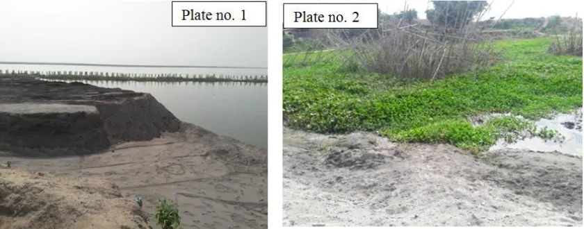
Plate. 1. Eroded land with sand bar by river erosion; Plate. 2. Settlement area changed into fellow land after the river erosion
Source: Field Survey, 2018
3.2.5 Effect on major industries
Mango production and sericulture are two important industries of the Malda district. Most of the people of this region depend on this type of economy. Due to flood, sericulture has suffered a loss to the tonnes of Rs. 10.00 crores and a good number of mango orchards have been damaged. Due to erosion of the river Ganga 42529.85 acres of land involving 28 mouzas of P.S. Kaliachak and 8 mouzas of P.S. Manikchak have been eroded. Out of these, 18 mouzas have fully been washed away and 10 mouzas have been eroded partly in the Diara region [14].
3.2.6 Changing livelihood pattern
Decadal changes of census Figs. show that a number of farm based workers in the Diara region are directly or indirectly affected by the impact of floods and river shifting [14,18].The land areas have shrunk because of erosion and the people in these regions (such as cultivators, agricultural labours, wage labours and fisheries)
are depressed because of dearth of
opportunities. The situation of families who depended on some forms of riverine activities like fishing or boat operation for livelihood had also deteriorated after the flood and river shifting. A sample of Gopalpur and Narayanpur villages of
Manikchak block shows that earning
opportunities of the resettled families are changing due to the scarcity of diversified livelihood opportunities.
3.2.7 Impact on different facilities
A number of other services and facilities are also affected by the vulnerable situation in the selected areas. The victims, in this case mostly the ‘environmental refugees’ are deprived of the minimum means of livelihoods in matter of health, education, safe drinking water, electricity and proper housing. In the village of Palgachi, near about 65 families has taken shelter in a school building on sharing basis. Two families are sharing each classroom with a temporary partition using plastics. Lack of privacy has adversely affected their family planning in matters of marriage and children. Even though some of the children are admitted to the nearby government schools, they do not have proper environment of studies at home. Consequently, the dropout rate is very high among the affected families. Considerable amount of iron and arsenic are found in the water which is mainly taken out using hand pump. Therefore, liver, heart, kidney related diseases are found among them.
Table 1. Changing livelihood pattern of the resettled residents
Villages Before Present
Cultivator Agricultural labour Cultivator Daily labour Fisheries Others
Gopalpur 42 2 2 24 6 8
Narayanpur 18 2 2 12 0 2
Plate. 3. Agricultural land converted into fellow land; Plate. 4. Agricultural land engulfed by the river erosion
Source: Field Survey, 2018
Plate. 5. Eroded village after flooding; Plate. 6. Dangerous location of village; Plate. 7. Unfavourable condition of village and Plate. 8. Daily mode of transportation of
villagers
3.3 Unsafe Conditions Leading to Vulnerability
3.3.1 Physical vulnerability
3.3.1.1 Dangerous locations of villages
The Ganga River located in the western part of the district. Among fifteen C.D. blocks of the district, five C.D. blocks under the Diara region fall under the river eroded areas. Among these five, four C.D. blocks namely Manikchak, English Bazar, Kaliachak II and Kaliachak III are highly affected by the river bank erosion due to their geographical location (Fig. 1). According to the field survey, altogether 88 villages in these C.D. blocks are affected and 42 villages out of total 88 are un-inhabited and the remaining 46 villages are vulnerable for their hazardous location which is mainly due to the close proximity to the river.
3.3.1.2 Unsafe infrastructure in villages
The civic infrastructures in many villages of Diara region like as Gopalpur, Narayanpur, Khaskol
Chandipur, Palgachhi, Piarpur and
Par-Anantapur are quite deplorable in terms of their physical strength. The road and sewerage system are very poor and there is prolonged water logging due to inadequate drainage system for the proper disposal of the waste water generated by the village households. At the time of rainy season, these areas are isolated from the neighbouring areas for its waterlogged conditions.
3.3.2 Economic vulnerability
3.3.2.1 Employment sectors at risk
The Diara region is a well-drained flatland formed by the alluvial deposition of newer alluvium and is very fertile for agriculture. Consequently, the livelihood of people in these areas is centred on agriculture. Most of the population are engaged agricultural sector. The continuous river bank erosion due to which agricultural lands vanish has become a cause of their miseries. This not only results to shortage of agricultural lands in these vulnerable areas but also uproots the people from their dominant source of economy.
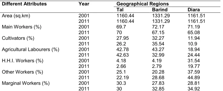
According to census report, the proportion of main workers within the rural workforce has declined whereas the proportion of marginal workers of the total rural workforce has increased. Secondary source of economy,
fishing, is also affected by this type of hazards. Due to a lesser amount of edification and limited options of employment opportunity in other sectors, the villagers in such vulnerable areas are forced to migrate to other states as wage labourers (Table. 2).
3.3.2.2 Low income level
The income level of people in these villages is quite low. The field survey (out of 100 HHs) of villages 11 HHs of Gopalpur, 8 HHs of Khaskol Chandipur, 5 HHs of Narayanpur and 10 HHs of Palgachi indicates an alarming scenario of economic condition of people as most of the households are living under the poverty level. Above 10 to 60 percentage of HHs, average monthly income is about rupees five thousands. A number of residents (family) of these villages neither have BPL cards nor has any access to the MGNREGA (Mahatma Gandhi National Rural Employment Guarantee Act) scheme. Surplus number of workforce, which is actually the result of loss of agricultural lands to the river bank erosion, leads to labour exploitation. Wage paid to the labourers is much lower to the minimum wage rate as fixed by the government. Consequently, the people are unable to enjoy a good quality of life. Their low financial status continues to increase their vulnerability to any kind of disaster.
3.3.3 Social vulnerability
3.3.3.1 The problem of low education
villages. The number of drop outs among the male is higher than the female (based on field survey). As a result, the people are mostly engaged in primary occupations which do not require any special skills or technical training. Due to the lack of proper education, villagers are involved in incommunicative activities.
3.3.3.2 Poor health conditions
Health issues are a matter of major concern in these vulnerable villages. Not only human beings but also the livestock get affected by the hazards. Vector-borne diseases like malaria, typhoid break out frequently due to the favourable conditions during the rainy season. Lack of hospitals and health centres in and around their make shift settlements very often aggravates the conditions of the patients and therefore, high rate of death of pregnant women and elders is observed in these vulnerable areas. In addition to it, absence of different scheme of immunization (pulse polio) affects the children’s health. But in the last two to three years, some positives changes have come in the health conditions of these people due to the implementation various Health and Nutrition schemes (ASHA, ICDS and Anganwadi centre). In spite of this, the overall intensity of malnutrition is still rampant in many parts of the vulnerable villages. Access to safe drinking water is one important precondition for long and healthy lives for the people of the area. Diara region is arsenic prone, so arsenic fluoride contamination is another serious problem in the region as well as the district.
3.3.3.3 Lack of public amenities
Among the 46 inhabitant villages, a few villages have secondary types of schools. The higher educational facilities are also inadequate. The minimum distance of the high schools and colleges is 5 and 10 km respectively. Good educational institutions and health facilities are also insufficient in these villages. The most shocking is the case of Kaliachak III block (only affected inhabited villages), where primary health centre is not at all available. Villagers of such areas cover 5 to 10 km distance to reach to the hospital or private clinic for treatment of their health problems.
And as per as drinking water is concerned, most of the villagers use hand pump or tube well for drinking purposes. A small numbers of villages have treated or untreated tap water facilities. Private tank is very costly and it is, therefore, not possible for everybody to arrange a private tank for clean drinking water for their family. Transport and communication is another grave area. Geographical location of certain villages caters to
adverse conditions on transport and
communication systems. There is always serious deficiency of proper means of public transport because of lack of connection to national highway, state highway and district roads. Most of the parts of the villages are connected with un-metalled or Kuccha type streets and lanes. Even the residents of such areas face the problem of proper sewerage system, the absence of which causes an unhygienic condition in these villages. Further the bank services among the villages are not sufficient.
Table 2. Changing livelihood pattern
Different Attributes Year Geographical Regions
Tal Barind Diara
Area (sq.km) 2001 1160.44 1331.29 1161.51
2011 1160.44 1331.29 1161.51
Main Workers (%) 2001 69.7 72.17 71.19
2011 70 67.15 65.08
Cultivators (%) 2001 27.95 32.27 11.94
2011 26.2 35.54 10.9
Agricultural Labourers (%) 2001 42.78 43.27 18.94
2011 42.63 32.99 24.44
H.H.I. Workers (%) 2001 4.18 4.19 31.54
2011 2.66 2.79 19.77
Other Workers (%) 2001 25.1 20.28 37.59
2011 22.19 28.68 44.89
Marginal Workers (%) 2001 30.3 27.83 28.81
2011 30 32.85 34.92
Plate. 9. Hauling style of motor-bike; Plate. 10. Unhygienic condition of village road
Source: Field Survey, 2018
3.3.3.4 Lack of disaster preparedness
The people of these villages are aware of all the problems arising out of this river bank erosion. However, they are not at all prepared to face any kind of disaster. Such low level of preparedness is actually due to their lack of edification and poor
economic status. Moreover, the local
government has taken no measures to increase the level of preparedness of the concerned population or villagers in order to mitigate the effects of the disaster occurring (especially bank erosion) in the nearby river bank areas [19].
3.3.4 Political Vulnerability
After the river bank erosion, vulnerable people face insecurity problems due to their loss of home land, loss of property and loss of occupation. Afterwards due to the displacements, people of such areas also face identity crisis in their internal land [20]. Border dispute or cross border conflict or rightful belonging to a state is major problem of the peoples who are settled in the adjoining border areas of the Malda district and the Jharkhand state. As a result, land eviction is a common phenomenon in those particular areas.
4. CONCLUSION
In the Maldah district of West Bengal, the course of upstream of the Ganga of the Farakka barrage continues to change unabated. Millions of rupees are invested every year for bank protection but no rehabilitation programme for the erosion
victims is in place. About 191.42 sq. km of fertile land have been eroded from the left bank of the river between 1931 and 1999 [21]. In a natural disaster like river bank erosion (which is a long process and it can continue in future) is essential to know the distance between affected people, potential affected people and estimate their vulnerability to be poor or socially excluded [22,23]. The villagers under the study area are facing problems in various services (health, education, drinking water supply, electricity, transport and communication) and economic
problems due to their close proximity to the river bank. The low income and low literacy rate
of the residents of these villages make them more vulnerable. The vulnerable people don’t just lose their land but they lose their identity by giving their way of life which is linked with the river.
COMPETING INTERESTS
Authors have declared that no competing interests exist.
REFERENCES
1. Yasir A. The political economy of disaster vulnerability: A case study of Pakistan Earthquake 2005. London, UK: London School of Economics & Political Science; 2010.
2. Dow K. Exploring differences in our
3. Proag V. The concept of vulnerabilty and resilience. Science Direct. 2014;369-376.
4. Wisner B, Blaikie P, Cannon T, Davis I. At
risk: Natural hazards, people's vulnerability and disasters, 2nd ed. Routledge, London; 2003.
5. O'Neil B. Women and displacement: A
case study of women displacement by Ganga erosion in Malda district of West
Bengal in India, Development and
Environment; 2010.
[Retrieved on October 13, 2017, from epc2010.princeton.edu/papers/100534]
6. Ahmed S. Impact of disaters caused by
river bank erosion bi brahmaputra under Barpeta District, Assam- A case study.
Imperial Journal of Interdisciplinnary
Research. 2016;2(8):1213-1217.
7. Hoque A, Haque R. River erosion:
Vulnerability & its social consequences on
the life of women: A study at
Chondonbaisha & Kutubpur in Sariakandi Bogra. Review of European Studies. 2013;5(4):99-117.
8. Laha C, Bandhyopadhyay S. Analysis of
the changing morphometry of river ganga, shift monitoring and vulnerability analysis using space-borne techniques: A statistical
approach. International Journal of
Scientific and Research Publication.
2013;3(7):1-10.
9. Singh K. Application of pressureand
release (PAR) model for assessing vulnerability to industrial hazards in District Bathinda, Punjub, India. Inter-national Journal of Management and Social Science Research. 2014;3(5):25- 29.
10. Saha S. Bank erosion of the river Ganga in
between Rajmahal and Farakka.
Darjeeling: Department of Geography and Applied Geography, University of North Bengal; 2012.
11. Rudra K. Ganga Bhangan Katha- Malda
and Murshidabad. Kolkata: Mreettika; 2004.
12. Sinha R, Ghosh S. Understanding
dynamics of large rivers aided by Satellite Remote Sensing: A case study from Lower Ganga plains India. Geocarto International. 2012;27(3):207-219.
13. District Human Development Report:
Malda, (HDRCC: Development and
Planning Department, Government of West Bengal); 2007.
14. District Census Handbook of Maldah
District; 2011.
15. 500 homeless in Bengal as Ganga
swallows land. (2018, September 24). The Hindu, retrieved on September 25, 2018. Available:https://www.thehindu.com/news/ national/other-states/500-homeless-in-
bengal-as-ganga-swallows-land/article25023544.ece
16. Mukherjee J. No voice no choice: Riverine
changes and human vulnerability in the 'chars' of Malda and Murshidabad. Kolkata: Institute of Development Studies Kolkata; 2011.
17. Maitra J. Boundary dispute between West
Bengal and Jharkhand: Correspondences and documents. Malda, West Bengal: CPI(M) District Committee; 2004.
18. District Census Handbook of Maldah
District; 2001.
19. Malda: With no govt help land erosion
victims struggle to sustain life. (2019, April 23). Business Standard, retrived on April 25, 2019.
Available:https://www.business- standard.com/article/news-ani/malda-with- no-govt-help-land-erosion-victims-struggle-to-sustain-life-119042300331_1.html
20. Anwaruzzaman AKM, Khatoon N.
Backwardness of Piarpur (Char) River
islanders: A geographical analysis.
Reseach Expo International
Multi-disciplinary Reseach Journal. 2012;2(2): 58-69.
21. Rudra K. Living on the edge: The
experience along the bank of the Ganga in Malda district. West Bengal. Indian Journal
of Geography and Environment.
2000;5:57-67.
22. Das T, Haldar S, Gupta T, Sen S. River bank erosion induced human displacement and its consequences. Living Review Landscape Research. 2014;8(3):1-35.
23. Iqbal S. Flood and erosion induced
population displacements:A
socio-economic case study in the Gangetic Riverine Tract at Malda District, West Bengal, India. Journal of Human Ecology. 2010;30(3):201-211.
24. Das B, Mandal M, Das A. Monitoring of
bank line erosion of river Ganga, Malda District, West Bengal: Using RS and GIS
compiled with statistical techniques.
International Journal of Geomatics and Geoscience. 2012;3(1):239-248.
25. Available:https://www.earthexplorer.usgs.g
ov
26. Maiti S, Ghorai D, Satpathy R,
land cover over the years due to river course shifting: A case study on Ganga river basin near Malda district, West
Bengal using Geo-informatices
Techniques. International Journal of
Research Advent Technology.
2014;2(10):83-90.
27. Moser C. The asset vulnerability
framework: Reasseessing urban poverty reduction strategies in world development. Urban Poverty Reduction Strategies in World Development. 1998;26(1):1-19.
28. Rudra K. Dynamic of the Ganga in West
Bengal, India (1764-2007): Implications for
science-policy interaction. Quaternary
International. 2010;161-169.
29. Rudra K. Shifting of the Ganga and land erosion in West Bengal: A
socio-ecological viewpoint. Calcutta: Centre
for Development and Environment
Policy, Indian Institute of Management; 2006.
30. Sanyal S, Mondal P. Channel dynamics
and settlement vulnerability: A micro study of Deoha River, Pilibhit District, Uttar Pradesh. International Journal of Geology, Earth & Environment Sciences. 2016; 6(3):41-49.
_________________________________________________________________________________ © 2019 Biswas and Anwaruzzaman; This is an Open Access article distributed under the terms of the Creative Commons Attribution License (http://creativecommons.org/licenses/by/4.0), which permits unrestricted use, distribution, and reproduction in any medium, provided the original work is properly cited.
Peer-review history: