NASA GES DISC Earth Science
Data Support
Jennifer Wei
1D. Ostrenga
1,2, B. Vollmer
1, and D. Meyer
11
NASA GES DISC
2
Adnet Systems, Inc.
Outline
•
Who are we?
•
How do YOU get the Data?
•
Data support
•
Recent released services
Types of support:
•
Archival of NASA designated data
•
Distribution of NASA designated data
•
Provide documentation support:
•
Writing user guides
•
Registering DOIs
•
Creating Data Interchange Format (DIFs) documents
•
Web content and interface development
•
Develop Value Added Services
•
User Support
•
Data and Service Metrics
•
Provide Ancillary Data Support
Data and Services Facilitate Research and Applications
Web Interface
• Web interface to data products and services
• Search and Download Mechanisms
• Data Set landing pages
GDS – GrADS Data Server
OPeNDAP - Open-source Project for a Network Data Access Protocol
OTF (On-The-Fly) Data Subsetter – Parameter, Spatial, Time, Vertical, Mean averaging, format conversion and regridding.
Giovanni – On-line Data Visualization and Analysis Tool which we have monthly and daily instances.
HTTPS direct online access – Direct anonymous HTTPS access
Subscriptions – to mission teams and other “power” users
Value-added generated data products– A-Train Data Depot (ATDD)
Redesigned interface
https://disc.gsfc.nasa.gov
More efficient and user friendly design to find the information and data you need with new capabilities to search by mission,
discipline, and other key information.
Accessibility from the Start!
• Help
Desk/Feedback/User Profile/Social Media
• Direct data product search
and mission search
• Find related documentation
• Link to services from the Gateway
How Do I Find What I Need? (2/3)
• Faceted Filter • Measurement • Source • Discipline • Temporal Resolution • Spatial Resolution, etc • Product ListingThe search result is a product listing of all available Products with the metadata tagged with your keyword. A more specific keyword will yield less more accurate
How Do I Find What I Need? (3/3)
•
Product
description
•
Documentation
Click on the data product name will
bring the user to the Data Set
Landing Page.
● News released in early May ● Missions:
○ 25 OMI Level 2
○ 10 OMI Level 2G products ● Instructional Aid:
○ HowTo Recipe
○ Webinar
● Next in the pipeline:
○ MLS/OCO2/GPM Products
○ Radial subsetting
○ Point subsetting
Capabilities:
● Selection of specific variables within a file ● Specification of a latitude-longitude box
● Subsetted variables output as cropped boxes (geolocation dimensions trimmed to smallest box containing subsetted data)
● Index variables generated for each of the subset dimensions, thus preserving original index values
● Dimensional subsetting ● Temporal subsetting
● Preservation of original file structure, metadata, dimensions, data types,
Capabilities:
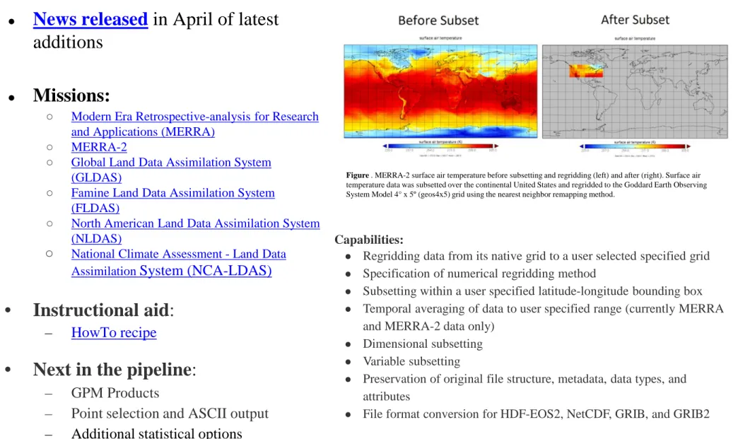
● Regridding data from its native grid to a user selected specified grid ● Specification of numerical regridding method
● Subsetting within a user specified latitude-longitude bounding box ● Temporal averaging of data to user specified range (currently MERRA
and MERRA-2 data only) ● Dimensional subsetting ● Variable subsetting
● Preservation of original file structure, metadata, data types, and attributes
● File format conversion for HDF-EOS2, NetCDF, GRIB, and GRIB2
Figure . MERRA-2 surface air temperature before subsetting and regridding (left) and after (right). Surface air temperature data was subsetted over the continental United States and regridded to the Goddard Earth Observing System Model 4° x 5º (geos4x5) grid using the nearest neighbor remapping method.
GES DISC Level 3 and 4 Regridder and Subsetter
● News released in April of latest additions
● Missions:
○ Modern Era Retrospective-analysis for Research and Applications (MERRA)
○ MERRA-2
○ Global Land Data Assimilation System (GLDAS)
○ Famine Land Data Assimilation System (FLDAS)
○ North American Land Data Assimilation System (NLDAS)
○ National Climate Assessment - Land Data Assimilation System (NCA-LDAS)
• Instructional aid: – HowTo recipe
• Next in the pipeline:
– GPM Products
– Point selection and ASCII output
User Support
Instructional Help
• User registration
• Web interface to data products and services
• Search and Download Mechanisms
• Data Set landing pages
• Getting Data
• Subsetting Data
• History Panel
• User Forum
• Help Desk ( [email protected])
Additional Instructional Aid:
• How-To’s : 47 entries• Glossary: 159 entries
• FAQ: 227 entries