IJIRT 143502
INTERNATIONAL JOURNAL OF INNOVATIVE RESEARCH IN TECHNOLOGY380
INDIAN REGIONAL NAVIGATION SATELLITE
SYSTEM
Rahul Rai Khatri
1, Sarvada Chauhan
21
B.Tech Final year, PDM College Of Engineering, Bahadurgarh
2Assistant Professor, PDM College Of Engineering, Bahadurgarh
Abstract- The IRNSS is an indigenously developing satellite based Navigation System that will offer an independent positioning & time services of Indian Subcontinent. IRNSS is developing under the auspices of the Govt. of India to ensure a sufficient Navigation system in hostile situations. Having own eyes in sky meant that government through IRNSS will provide two services, with Standard Positioning Service which will be open to the civilian use and, the high end restricted service meant only for highly authorized users such as Army .
Index Terms— GNSS, India, IRNSS, Navigation, Surveillance
I. INTRODUCTION
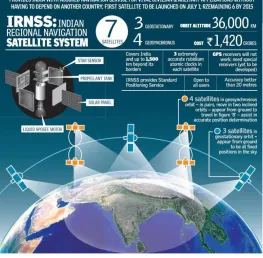
IRNSS is an indigenously developing Navigational Satellite System that will be use to provide real time positioning & timing services over India & region extending to 1500 Km. IRNSS will be armed with a constellation of 7 satellites. However the full system comprises nine satellites, two on ground as standby. The IRNSS system was planned to be operational by end of 2016. The IRNSS was conceived in 2006 by the government for both Space & Ground infrastructure with an allocation of about Rs. 1420 crore . The requirement of such a navigation system was driven because access to foreign government controlled GNSS isn’t guaranteed in hostile situation as happened with Indian Military on depending on American GPS during Kargil war .
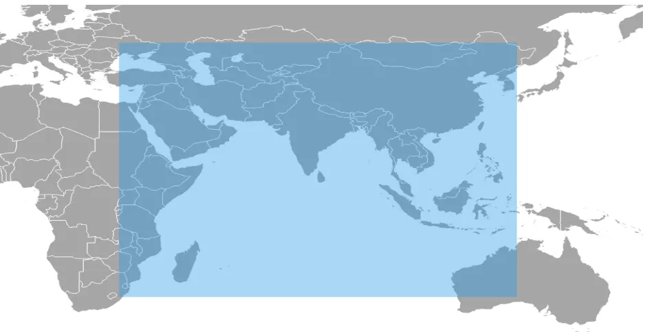
The IRNSS is expected to provide better positioning accuracy than GPS in the region centered around the country with the coverage extending to 1500 km around India between Longitude 40 E to 140 E and between Latitudes +40 to -40. A much larger secondary service is extended from 30 to 130 east Longitude & 30 S to 50 N Latitude.
IJIRT 143502
INTERNATIONAL JOURNAL OF INNOVATIVE RESEARCH IN TECHNOLOGY381
them with corrected orbital & time information. The Control Segment of the IRNSS constellation consist of a Master Control Station( MCS) stationed in Karnataka and several other ground control stations. The Ground Station receives data from the satellites & then sends that information to the MCC where it makes necessary ionospheric clock corrections & run the Navigation software. In pursuit of an independent system, an Indian Standard Time infrastructure would also be established. The satellite service will provide SPS for civilian uses & RS with encryption for armed forces.
The navigation signals would be transmitted in the S-Band frequency ( 2-4Ghz) and broadcast through a phased array antenna to maintain the requisite coverage and signal strength .the system expected to provide an absolute position accuracy of about 10 metres over India as well as the region extending 1500 km around India. The system will provide accurate Position, Navigation & Time (PNT) services on various platforms with all the time availability under all environmental conditions.
Fig. 1: Illustration of the IRNSS coverage which includes an area of ~1500 km around the Indian land mass ( Image Credit : ISRO )
ISRO had also developed a Geo Augmented Navigation System called GAGAN which is currently supported by GPS to assist the navigation of Civilian air traffic within Indian Airspace. Once the IRNSS & GAGAN are fully operational , they will help with precise navigation, provide data on mountainous, oceanic areas & enhance security tremendously .The vast spectrum of services that would be provided by the network will be significant to the growth of the Nation in the field of science and space technology which would propel our economic growth in the years to come. The more satellites that
the Receiver can ‘ see ‘, the better the accuracy ,Signal reception can be blocked by building ,terrains, electronic interference & sometimes dense foliage a cluster of 7 satellites could be seen by the receiver giving more accuracy than GPS.
IJIRT 143502
INTERNATIONAL JOURNAL OF INNOVATIVE RESEARCH IN TECHNOLOGY382
position, velocity & time observables for users on a variety of platforms with 24 hours x 7 days service availability under all weather conditions. The IRNSS was being developed parallel to the GAGAN program, the ISRO SBAS( Satellite Based Augmentation System) version of an overlay system for GNSS signal corrections.
II. IRNSS ARCHITECTURE
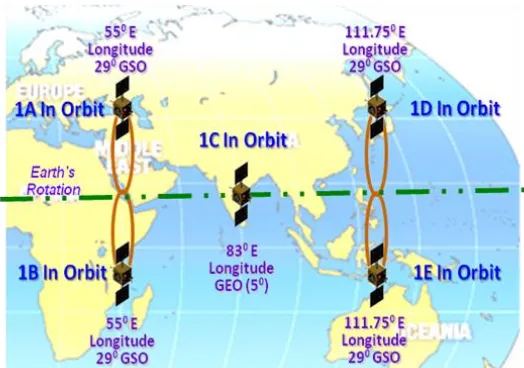
THE SPACE SEGMENT consist of a constellation of seven satellites: three Geostationary Orbit (GEOs) located at 32.5 East , 83 East & 131
East Longitude & four Satellites(GSO) in Geostationary Satellites(GSO)in orbit of 24000km apogee & 250 Km perigee inclined at 29 degrees .Two of the GSOs will cross the equator at 55 East & other two at 111.75 East ( two satellites in each plane). The constellation design consideration have been
mainly :
a) Minimum number of satellites b) Orbital slots for India for a continuous
visibility with the control station.
Fig 2: IRNSS Constellation after IRNSS 1-E ( Image Credit : ISRO )
Major role played by IRNSS payload are: a) Transmission of the navigational timing
information in the L5 bands b) Transmission of navigation, timing
information in S-band.
c) Generation of navigation data on-board d) CDMA ranging transponder for precise
ranging
The Navigation payload carried in the Satellite is in redundant configuration & has following subsystems:
a) NSGU( Navigation Signal Generation Unit)
b) Atomic Clock Unit (Rubidium atomic clocks)
c) Clock management & control unit d) Frequency generation unit e) Modulation Unit
IJIRT 143502
INTERNATIONAL JOURNAL OF INNOVATIVE RESEARCH IN TECHNOLOGY383
Fig 3 : The picture shows how the Indian Regional Navigation Satellite System provides assured navigation services to every individual on the street. ( Image Credit: ISRO )
THE GROUND SEGMENT of the IRNSS consist of :
a) IRNSS Spacecraft Control Centre ( SCC) b) IRNSS Navigation Centre (INC ) c) IRNSS TTC & station Uplink Station (
IRTTC )
d) IRNSS Range & Integrity Monitoring Stations ( IRIMS )
e) IRNSS Timing Centre f) Laser Ranging Station ( LRS )
g) Data Communication Network ( IRDCN ) The SSC & the INC will be the core of the ground segment & they’re in charge of estimating & predicting IRNSS Satellite position; ionospheric & clock correction & running the navigation software. 17 IRNSS sites will be distributed across the country for orbit determination & ionospheric models. The
IRNSS timing will consist of two widely stable clocks.
THE IRNSS USER SEGMENT is made of the IRNSS users & the IRNSS Receivers. There will be dual frequency ( L5 or S Band frequency ) with capability to receive ionospheric connection. They’ll be able to receive and process navigation data from other GNSS( Global Navigation Satellite System ) constellation & the seven IRNSS satellites will be tracked by the user receiver. The user receiver will have a minimum gain, G/T, of -27 db/k.
IJIRT 143502
INTERNATIONAL JOURNAL OF INNOVATIVE RESEARCH IN TECHNOLOGY384
(Restricted Services) in order to help provide better acquisition & performance. As each L5 band & S Band contains three signals, the IRNSS design adds an interplex signal in order to maintain the constant envelope characteristic of the composite signal. The transmission is done using the L-Band and S-band helix array antenna to provide global control in right-hand circularly polarized (RHCP) signals. Thus, user receivers can operate in single/dual-frequency mode.
Potential Errors possible in IRNSS Receiver may due to following sources :
a) Orbit Errors: Satellite Orbit (referred to as ‘ Satellite Ephemeris ‘) pertains the altitude , position & speed of the satellite. Satellite orbits vary due to gravitational pull & solar pressure fluctuations. Orbital Errors will be monitored & corrected by the Master Control Station.
b) User Mistakes account: Incorrect datum & typographic errors when inputting
coordinates into a IRNSS receiver can result in errors up to many kilometers.
c) Satellite Clock Errors: Cause by slight discrepancies in satellite’s automatic clocks. Errors will be monitored & corrected by the Master Control Centre,
d) Ionospheric Interference : The Ionosphere is the layer of atmosphere from 50 to 500 km altitude that consist primarily of ionized air. Ionospheric interference may causes the satellite radio signals to refract as they pass through the earth’s atmosphere-causing the signals to go up or down.
REFERENCES
[1] Ganeshan A. S., Rathnakara S. C., Gupta R., Ja in A.K. (2005) ―Indian Regional Navigation Satellite System
(IRNSS) Concept‖, ISRO Satellite Center Journal ofSpacecraft Technology, 15(2):19 -23.
[2] Ganeshan A.S. (2012) ― Overview of GNSS and Indian Navigation Program‖, GNSS User Meeting, 23 Feb. 2012,ISRO Satellite Center, Bangalore.
[3] Sa ikiran B., Vikram V. (2013) ―IRNSS Architecture and Applicat ions‖, KIET Int. J. of Co mm. &Electron.,
1(3):21-27.
[4]Surendra Pal, A. S. Ganeshan, K. N. S. Rao, L. Mruthyunjaya, "Indian Regional Navigation Satellite System,"
Proceedings of the 58th IAC (International
Astronautical Congress), International Space Expo, Hyderabad, India,
Sept. 24-28, 2007, IAC-07-B2.1.01
[5] Harshada Harde,Prof.M.R.Shahade,Diksha Badnore, “Indian Regional Navigation Satellite System,”,IJRISE, e-ISSN: 2394-8299
[5]ParimalMajithiya, Krit iKhatri, J. K. Hota, "Indian Regional Navigation Satellite System," Inside GNSS,