(PLATES 45-49)
A T the southeast corner of the plain which contains the ancient city of Phlious,
two roads lead south and east from the outskirts of the modern town of Nemea (Fig. 1). The more easterly of the two is the modern asphalt highway which passes over the intervening hills to the site of ancient Nemea and then joins the major north-south route to the Argive Plain just north of the opening of the Dervenaki Pass. The second road, unpaved, follows the flat land towards the south between the precipitous Mount Polyphengo on the west and Mount Analipsis on the east. This way is taken by most topographers to be the Kelossa Pass and would have been the most direct route from Phlious to Argos in antiquity.' The road forks at a conical mountain, appropriately named Mount Strongylo, which rises in the midst of the pass. One fork turns farther southwest, eventually reaching the Argive Plain in the area of the Inachos River. The other route proceeds along the east side of Strongylo and emerges in the Argive Plain close to the modern hamlet of Phychtia and opposite ancient Mykenai. Along this route on the south or back side of Strongylo the remains of a bridge for an ancient aqueduct can be seen nestled well back and almost invisible from the road.2
Strangely enough the aqueduct seems not to have been recorded by any of the early travelers to Greece in the 18th and 19th centuries. Although the Kelossa Pass was still a major route from the Phliasian Plain to Argos and was traveled by a
1 For the identification of the pass, see W. K. Pritchett, Studies in Ancient Greek Topography,
Part II (Battlefields), Berkeley 1969, pp. 98-99. The sketch, Figure 1, was adapted by John Huffstot from the map (fig. 11) in this work published in 1969 by the Regents of the University of California, reprinted by permission of The University of California Press.
2 This little study could not have been undertaken without the help of a number of people and
it is a pleasure to be able to thank them publicly here. Mr. Charalambos Kritsas of the Greek Archaeological Service first suggested the project and Mrs. Evangelia Deilaki, Ephor of the Argolid-Corinthia, very kindly provided the necessary permissions and understanding. The actual fieldwork was undertaken during a particularly cold week in April of -1976 with funds supplied by the Resea,rch Council of the University of Missouri-Columbia. Roger Holzen acted as architect and prepared the excellent drawings which accompany this article. The photographs of the first three plates were taken by Ioannidou and Barzioti of Athens. A student of the American School and the University of Missouri, Pamela Ilene Berich, assisted the study during the field work and it is a particular pleasure to thank her for her professional attitude and good humor in trying circum- stances. Mr. Parmenio Demetriou of New Nemea again aided us in many ways.
This article has benefited by discussions with a number of colleagues, especially Pierre Aupert of the French School at Athens, Gerhart Schmidt of the German Institute, Susan Walker of the British School, William Dinsmoor, Jr., T. Leslie Shear, Jr., Photios Petsas, to name only a few. Finally, I must once again express mny thanks to Corinth Excavations and its Director, Charles K. Williams, II, for the loan of equipment and encouragement and the then Director of the American School, James McCredie, for a willingness to lend a sympathetic ear.
American School of Classical Studies at Athens is collaborating with JSTOR to digitize, preserve, and extend access to Hesperia
TO~~~~~~~~~~~~N
.2"I~~~~~~~~~~~~~~~~~~~~~~~~~~~~~~4
J 3 : ' M s c-i
fbt~
js~~~~~~~~~~~~~~~~~~~~ ~~0.~~g ~ " N
%~~~~
>~~~~~-
(~~~~~~~@0 ~ ~ ~ ~ ~ 7 >
Aiiianis~~~~~~~~~~-I
*% .w
1601 ~0~~~~~~
ev~A.oa
"1ff ~~~~~~~'.*A :0 .: ~~~~~~~ROA / D
...A - . 11?7NC *"'.
.1
. ::sfl.ci;
TOWN~~~~~~MY. POL %I .OWN
tr"' t~~~~~~~~io.-....0 0 ..0...&....
47?' .. I I i~~~~~~~~~~~~~~~ p~~l I
S .. Z" L
~~0q OQ.?~~~4-SAom i '~~~~ AOUEDIJ
~~~~~~~~~~E
J.
bJ LEVATION S AREj~~~:.4*'
IN
METERS
To S4orn4 Argw ~ Argo
number of visitors, the remains were only first recorded by August Frickenhaus and Walter A. Muller in the " Tagebuch " of a trip they undertook in the Argolid in 1909.' The first published reference appeared in 1924 in an article by A. G. Russel on the topography of the area in which its existence is simply stated:
Twenty minutes later, in a gorge to the right and 450 metres up from the road, is a large
Roman or Byzantine aqueduct of two tiers of arches, with piers of large square poros blocks and upper works of stone and mortar.4
E. Meyer in 1941 added only that the remains were preserved to a height of 11 meters but makes the suggestion that the fragment forms part of an aqueduct implied by Pausanias when he stated that the Emperor Hadrian had water brought from
Stymphalos to Corinth.5 This suggestion has been enthusiastically adopted by suc- ceeding scholars including Roux 6 and Pritchett, who published the first photograph of the bridge.7
The identification of these remains with the gigantic undertaking hinted at by Pausanias depends on the date of the bridge and on the route of the Hadrianic system. Both these subjects are taken up below.
THE REMAINS
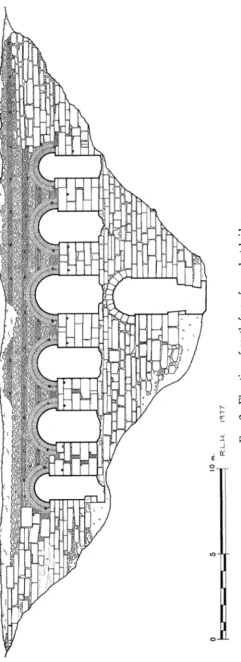
The principal preserved portion of the aqueduct consists of an arched bridge which lies approximately west to east 8 across a deep ravine which divides the south
side of Strongylo from the hills farther to the south and east (P1. 45). Its over-all preserved length is some 35 meters and its greatest preserved height is approxi- mately 11.90 m. to the floor of the gully where a stream passes through it by way of a single arched opening. As Russel observed, two tiers of arches are preserved with the single opening on the lower tier and six on the upper, irregularly spaced with one above the lower arch, two to the east and three to the west. The construc- tion is mortared rubble faced in the lower portion with cut blocks " and interrupted
3 E. Meyer used this " Tagebuch " as one of the sources for his article on Phbious and vicinity
(" Phleius," RE, 29, 1941, cols. 270-290). Frickenhaus' trip resulted in an artlicle ("Aus der
Argolis," AthMitt 36, 1911, pp. 21-38) which although discussing Phliasia, omited any references to the remains. The short description in the " Tagebuch," complete with sketch plan, unfortunately only indicates that the remains were substantially the same in 1909 as they appear today. I am indebted to Prof. Walther Wrede for supplying information from this notebook which is at this time (Spring, 1976) in his posssession.
4A. G. Russel, " The Topography of Phlius and the Phliasian Plain," Liverpool Annals of Archaeology and Anthropology 11, 1924, p. 45.
B
E. Meyer, op. cit. (footnote 3 above), col. 280; Pausanias, II.3.5, VIII.22.3.
8 G. Roux, Pausanias en Corinthie, Paris 1958, p. 163.
7W. K. Pritchett, op. cit. (footnote 1 above), p. 224, pl. 66.
8 The exact orientation is more specifically northwest-southeast, but the simpler direction is
retained here.
1 [ 1 tVY 2r | ' ' c p ___>
=t ~~~~~7 -~ -> '1 - r- f
-~~~~~. F
0J 5 10 m.
R .L. H. 1977
in the upper portion with strips of bricks. Although badly broken along the top, the bridge is generally well preserved, especially on its south side. Although the drawing of this side (Fig. 2) and the photographs of both sides show the general nature of the construction, a few specific points may be considered.
The single opening of the lower tier is roofed by an arch of thirteen blocks evidently cut to fit their position (P1. 46). Apart from these, however, almost all the rest of the facing on both sides up to the tops of the piers appears to be composed of re-used ancient blocks whose variety of shapes, anathyrosis, clamp cuttings, etc., betray their origin. Most of these blocks are rectangular or approxi- mately square building blocks roughly set into the concrete core of the building with little attempt at careful workmanship. Where large spaces existed between individual stones, the joints were simply filled with brick and mortar courses. This can be most clearly seen in the first pier from the west on the south face (Fig. 2, P1. 46). The bricks employed in these areas do not differ to any extent from those used elsewhere in the aqueduct, having an average thickness of 0.0346 m. while the mortar varies from 0.0125 to 0.038 m. with an average of ca. 0.031 m.
Together with the greater number of plain rectangular or square blocks, some architectural members can be seen well sunk into the fabric of the bridge. Among these on the north face are four column drums with empolion cuttings, ca. 0.048 m. in diameter, and an engaged column drum about one meter in length. These particular blocks are so badly worn or covered with concrete that it is difficult even to discover if they belong to the Ionic or the Doric Order. A number of step blocks of varying heights from 0.19 to 0.26 m. with both two and three sunken fasciae, a coping block used as a base course below the second pier from the west on the north face, and crowning and base moldings for various monuments can also be seen. An Ionic bottom column drum with its base is placed high up in the north face (P1. 48:a) and is of small scale although impossible to measure in its present position. A number of other blocks could be identified as coming from an Ionic entablature. The best preserved of these is an epistyle-frieze block shown in profile in Figure 3 and in Plate 48: b. It is cut in a single block of limestone, and it is very small (only 0.385 m. in total height). A number of blocks belonging to this entablature and bearing identical moldings are built into the aqueduct along with those mentioned above. Generally similar in size and scale, it would appear that the remains of at least one building and of monuments perhaps connected with it were re-used as facing. Unfortunately, no traces of inscriptions were found, although one block in the second pier from the west bears a cross cut into its west face (P1. 49: a).
176 WILLIAM R. BIERS
both in the spandrels and above the arches. They measure ca. 0.12 m. in height and 0.10 m. in width where they appear in the brickwork.
The arches themselves spring from approximately 0.12 m. back from the faces of the piers and are constructed of double rows of bricks laid radially. The bricks lhere vary in height between 0.028 and 0.036 m. with an average of ca. 0.0351 m. and
co
0.44 m
0 0.1 0.ZM.
R. L.H. 1977
FIG. 3. Profile of epistyle-frieze block.
a length of 0.272 m. on the average. They are laid quite carefully but have weathered badly so that much of the mortar has fallen out of the joints and in many places the bricks themselves have been broken away.
The alternation of mortared rubble and bricks begins in the area of the spandrels; immediately above the pier and between the two arches a section of bricks and mortar is carefully laid with one short and one long brick on each course alternating in position to east and west. The lowest course of bricks on top of the pier acts as a string course for both the arches and the spandrel, and above it rise six courses of carefully laid brick. The mortar shows definite beveling of its surface so that the top of each brick is slightly exposed. The bricks here vary in height from 0.030 to 0.033 m. with an average of 0.0315 m. while the mortar varies between 0.04 anld 0.02 m. with an average of 0.032 m. Above the bricks comes a section of mortared rubble, a brick course, and another section of rubble. The mortared rubble is made up of blocks of stone of various sizes, mostly rectangular, laid in a coarse mortar. In places where the surface is well preserved traces of incised lines can be seen, some running straight along the face, others in the form of zigzags and triangles. It is probable that this pointing would have decorated all the mortared surfaces of the bridge, giving it a more polished appearance than it has now.
A strip of brick facing, four bricks high, passes above the crowns of the arches along both faces. Above this is another and thicker section of mortared rubble, this time containing more rounded and fist-sized stones, but with a very badly destroyed surface. Another strip of bricks, four bricks thick, lies above, and over that more rubble to the preserved top of the bridge. The top surface here is completely missing so that it is uncertain how much higher the final rubble portion once existed. The bricks in the face of the aqueduct are again similar to those used in the arches and as filling between blocks. The heights vary from 0.028 to 0.035 m. with an average of 0.0317 m. The mortar joints again vary between the extremes of 0.022 and 0.043 m. with an average of 0.0316 m. As has been mentioned, where the surface is well preserved the mortar is beveled back to reveal the top surface of the brick below. This is true not only in the spandrel but also where the surface is well preserved at the east end on the south face and probably was the rule through- out (P1. 48: c). The length of the bricks again stands at ca. 0.27 m. In two places two sides of a single brick could be measured, which yielded dimensions of 0.265 and 0.28 X 0.275 m. Only approximately square bricks could be identified with any cer- tainty with exposed lengths varying from 0.265 to 0.278 m., but most measuring 0.27 m. Apparently, then, our bricks are whole pedales, although somewhat shorter on the average than the canonical 0.296 m. found at Argos.10
The top surface of the bridge is irregularly destroyed and trampled as a result of its use as a foot path over the ravine. There is no obvious trace of the specus but a straight line in the upper surface at the east end of the bridge may preserve its original position (P1. 49: b). No traces of waterproofing or brick construction can
178 WILLIAM R. BIERS
be seen, only a relatively flat space bordered on the south by mortared rubble which stands some 0.20 m. higher. On the north the floor is broken away. The line of this narrow area can be discerned starting approximately 1.20 m. west of the east end of the bridge and extending some seven meters before terminating against what
_~~~~~~~~~~~~~
0
0.5
1.0
I.5m.
"f
l
R.L.H. 1977FIG. 4. Section of water tunnel from south.
appears to be a solid lump of concrete. It may be that this straight line only preserves a construction detail from the laying of the concrete.
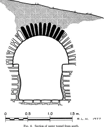
Although not visible in the illustrations which accompany thlis article because of vegetation which could not be removed, at both ends the aqueduct begins to veer away from the straight line it follows across the stream. At the east end the lower courses clearly begAin to diverge to the north to pass along the slope of the hill. The foundations are roughly broken off here, as if a large portion had fallen down the hill, and nothing more can easily be made out, the aqueduct no doubt going underground once having crossed the gully. On the west end the same divergence towards the north is noticeable where the underground tunnel for the water followed the slope of Strongylo on its east side. Here, a few meters to the northeast and above the bridge, a small section of the underground portion of the aqueduct was investigated. Part of the arched roof was visible and as the tunnel had been utilized in part as a place of safekeeping it was possible to clean out the modern debris (Fig. 4, P1. 49: c). A section only ca. 1.60 m. long by 0.90 m. wide was cleared down to the floor in an area ca. 1.40 m. in length, through an accumulated fill ca. 0.75 m. in depth. The tunnel continues towards the northeast and then follows a more northerly course along Strongylo's east flank; it is at least partially open as far as light can penetrate. The construction is simple and economical, utilizing local limestone split into rectangular fragments and laid as if they were bricks.
The floor as found consists simply of flat stones laid without mortar in a hard red earth. Probing indicated at least another layer of stones below the upper one. The walls of the channel are constructed of field stones to a height of ca. 0.82 m. The arch of the tunnel springs from the top of these walls and is also constructed of thin slabs of stone shaped like bricks and laid radially as a brick arch. An unusual feature of the tunnel is that, as far as could be determined in the small area opened, the west wall, which is set against the slope of the hill, is not mortared. In fact, it appeared that it was only at the point where the arch begins to swing out, away from the hill slope, that the architects felt it was necessary to mortar the joints. The arch from this point on and the east wall show traces of a coarse gray mortar.
Examination of the vertical walls of the tunnel was hampered by a thick coating of plaster which is preserved to 0.18-0.25 m. from the tops of the walls. The plaster in fact shows three distinct layers. The first, next to the wall, is a coarse gray with pebble inclusions c. 0.015 m. in width. On top of this is a finer reddish plaster, ca. 0.0075 m. thick, with a smoothed top surface. Finally, a coarse reddish coating without any inclusions varying in thickness but averaging ca. 0.02 m. is pre- served. This coating appears to widen towards the bottom of the channel as is shown in Figure 4, perhaps indicating a long period during which water flowed at a rela- tively low level. The width of the tunnel, originally over one meter at floor level would certainly indicate that a large amount of water could be transported.
180 WILLIAM R. BIERS
IDENTIFICATION AND DATE
The question as to whether or not our bridge belongs to a great aqueduct which brought water from Stymphalos to Corinth rests in the first analysis on its geo- graphical position and what is known of the route of the Hadrianic system. The sole literary evidence for the existence of such a system lies in Pausanias' two refer- ences." In both of these it is simply stated that Hadrian brought water from Stym- phalos to Corinth, without any details or mention of any construction to carry out this feat. Our entire published knowledge of the probable route of such an aqueduct goes back to the 19th century and the Expedition scientifique de Moree, and the state- ment of the route by Puillon-Boblaye." Practically all succeding references to the aqueduct simply repeat or paraphrase the routing as given by this author."3 The French architects, probably relying on the general topography and the location of remains of Roman construction reported by various travelers, bring the aqueduct along a southern route from Stymphalos to the valley of the Inachos River north- west of Argos by way of the Plain of Ancient Alea. Remains of an aqueduct have been known for some time near the village of Sterna on the north side of the Inachos valley well south of our remains and it was these the French architects evidently had in mind in choosing their course. From this point, the aqueduct is rather vaguely said to follow the northern and western slopes of the mountains back up through the Argive Plain, maintaining sufficient height to get over the Dervenaki Pass and thence to Corinth. The remains above Sterna, which served as a main point of reference for this route, have been, however, plausibly connected with an aqueduct which brought water to Argos from local sources; the water fed the Nymphaion at Argos which was built in Hadrianic times or shortly thereafter, as was the aqueduct which fed it."4 If one can divorce the remains in the valley of the Inachos River from a system which brought water from Stymphalos to Corinth, it is then possible to give the latter system a more northerly course which would have the advantage of both a shorter and a more direct route.
According to local information, the tunnel of our aqueduct can be traced back
"See footnote 5 above.
12 E. Puillon-Boblaye, Recherches geographiques sur les ruines de la Moree, Paris 1836, p. 148.
13 E. Curtius, Peloponnesos I, Gotha 1885, p. 206; J. G. Frazer, Pausanias's Description of
Greece IV, London 1913, p. 274; H. Hitzig and H. Bluemner, Pausancte Graeciae Descriptio III, Leipzig 1907, p. 184; F. B6lte, " Kephisos," RE XI, 1921, col. 249.
14 W. Vollgraff, " Fouilles et sondages sur le flanc oriental de la Larissa," BCH 82, 1958, pp. 555-
556. The inscription on which the dating of the Nymphaion is based is published by Vollgraff in BCII 68-69, 1944-45, pp. 397-400 and his tracing of the route from the sources appears in BCH 44, 1920, pp. 224-?25.
B61te pointed out in his RE article (loc. cit., footnote 13 above) that the earlier writer A. Meliarakis, while repeating the traditional route to Corinth, in a separate discussion assigned the remains near Sterna to an aqueduct which went to Argos. It is not clear whether he thought of the two systens as one (rPEaypawla TroXLrtLK3 vEa Kat apXaLa 7)ov vopiovi 'ApyoXtiog vat Koptvtas, Athens 1886,
from where we investigated it north around the east slope of Strongylo and then towards the west along the north slope of Mount Megalovouno. More remains are reported near the modern towns of Gymnon and Platani, north of Mount Pharmakas (Fig. 1). It is further said that remains are traceable from there to Stymphalos. Similarly they are said to be traceable from our area to Corinth presumably turning north somewhere to the east of the bridge. Without close investigation of these assertions, it is probably not possible to say more than that our remains certainly lie where an aqueduct from Stymphalos to Corinth could lie. Our bridge, the crown of whose arches actually slopes slightly towards the southeast, would appear to be going in the right direction."
The suggestion that our bridge is part of an aqueduct constructed by Hadrian runs into chronological problems when its construction is studied, for details and its over-all characteristics would seem to fit more easily into a post-Hadrianic era.
The use of bricks in Greece in Roman times is beginning to be investigated, thanks to R. Ginouves and his studies of brick buildings at Argos."8 The bricks used in our aqueduct are generally fired pink/red to yellow/green and are laid in somewhat coarse, light gray mortar. They are consistent in being square pedales, on an average 0.272 m. on a side, with a height which varies from 0.028 m. to 0.036 m. with an average of 0.033 m. Mortar courses vary widely between 0.0125 and 0.043 m. with an average of 0.031 m. In general, when compared to the Argive material the bricks in our aqueduct are marginally too thin and the mortar too thick for buildings of the Hadrianic period in Argos. On the other hand, constructions of the 4th century in Argos such as the areas datable to this period in the " Thermes du theatre" 17 show thinner bricks and thicker mortar (average 0.025 m. and 0.035 m. respectively). On the basis of the Argos brick evidence, our bricks must fall between these extremes, with no really close parallels in both brick and mortar thicknesses, although one's general inclination on the basis of brick thicknesses and workmanship is to place our bricks before the end of this period."8
15 This short study is not principally concerned with the route of the Stymphalos to Corinth
system, which would be a major study in its own right. It is probable that some conflation of remains has occurred and only a careful topographical study can untangle the confusion. From time to time various stretches of ancient masonry have been reported from this area of the Peloponnesos and ascribed to this system. It has not been possible within the scope of this study to visit all of these. A brief inspection was made, however, of the familiar long stretch of masonry above the modern villlage of Agios Basileios on the south side of the plain of ancient Kleonai. Remains of water proofing and a water channel indicates that it is indeed an aqueduct and its building technique does not exclude it from being a part of the great system.
16 R. Ginouves, op. cit. (footnote 10 above), pp. 217-245. 17 Ibid., p. 234.
18 At the present state of our knowledge it is difficult to push this brick evidence for several
182 WILLIAM R. BIERS
Of all the blocks of varying sizes and shapes built into the lower portion of the bridge, only the entablature block illustrated in Figure 3 and Plate 48: b is well enough preserved or significant enough to yield much information for study, and even this block gives only a rather general terminus post quem for its re-use. Its small scale makes dating difficult at best, but the over-all treatment and the profiles seem to point to Imperial times, probably no later than the 2nd century after Christ, but again there can be little certainty.19
The general aspect of the aqueduct bridge with the arches of double rows of radially laid bricks and the mortared-rubble construction employing strips of brick appears to be generally later than the Hadrianic period.
The use of double rows of bricks for the voussoir of an arch is difficult to parallel in Greece before the late 3rd or 4th centuries after Christ,20 but this may be due to the lack of dated examples, both published and otherwise, since double rows are known in Italy from early Imperial times 21 and in Asia Minor probably as early
as the 2nd century.22
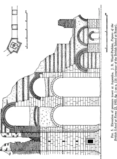
For the closest over-all parallel in construction one is forced to go some distance away to the aqueduct at Aspendos where the same method of construction, cut stone and mortared rubble with brick coursing, once thought to represent an earlier and a later period of construction, has been shown by Ward-Perkins to be contemporary
(Fig. 5).23 Here the brick courses go right through the structure unlike ours which
19 Althougrh parallels for individual components of our block can be found in Corinth (cf. the
building along the west terrace datable to the first two centuries after Christ, R. L. Scranton, Coritth, I, iii, Monuments in the Lower Agora and North of the Archaic Temple, Princeton 1951, pp. 3-73), it is difficult to date it more closely.
20 Two rows of bricks forming aln arch are quite common in "Galerian " constructions in
Thessalonike, for instance in the Mausoleion, A. Boethius and J. B. Ward-Perkins, Etruscan and Roman Architecture,, London and Baltimore 1970, pl. 275 and the Odeion Stoas, AEr 26, 1971, B'2, pl. 351. Double rows of bricks are also used in the arches of the bridge which is preserved in the valley of the Louros River and which belongs to the aqueduct of Nikopolis. I am indebted to Professor C. W. J. Eliot for this obse,rvation taken in April of 1976. See Ph. Petsas, 'Apx'E4o 1950- 1951, XpOvKKa, p. 40, figs. 17, 18.
21 Blake mentions a number of examples from Julio-Claudian times. Particularly interesting is
the Domitianic branch of the Aqua Claudia which had high arches with a double voussoir curve of sesquipedales over bipedales and lower arches of bipedales. M. Blake, Roman Construction in Italy from Tiberius through the Flavians, Washington 1959, p. 123, pl. 29, fig. 1.
22 In Pergamon the arches in the building known as Kizil Avlu, perhaps a temple of Sarapis,
may belong in the 2nd century although the authorities seem to disagree on the chronology. Both E. Beothringer (" Pergamon," Neue deuttsche Ausgrabngen int Mittelmeergebiet und im Vorderen- Orient, Berlin 1959, p. 136) and W. Heilmeyer (Korimthische Normalkapitelle, R8mMitt, suppl. vol. XVI, Heidelberg 1970, pp. 88-89) date it in the earlier part of the 2nd century, the latter empha- sizing Trajanic parallels. Ward-Perkins first suggested a date " somewhere about the turn of the second and third centuries" (The Great Palace of the Byzsantine Enmperors, Second Report, ed. D. T. Rice, Edinburgh 1958, p. 85) but more recently has placed it at the beginning of the 3rd century (op. cit., footnote 20 above, pl. 205, capttion). I must thank Stisan Walker for drawing my attention to this building.
23 J. B. Ward-Perkins, "The Aqueduct of Aspendos," BSR Papers 23, 1955, pp. 115-123.
0
M;. . X,1 ... 9* R; ;
As
FIG. Elevation of pressure tower at Aspendos. J. B Ward Perkins, Papers of the Brit'sh School at Rome 23, 1955, fig. 1 on p. 116 (courtesy of the British School at Rome)
184 WILLIAM R. BIERS
are simply facing, but both aqueducts employ brick arches of double rows of bricks and seem generally similar in their over-all appearance. Unfortunately, the example at Aspendos is not closely dated, falling into the general period of mid-2nd to end of 3rd century after Christ. Ward-Perkins originally rather hesitantly assigned it to the " the middle or second half of the third century " while not ruling out an earlier date,24 but more recently he has repeated the later, 3rd century date.25
Thus, at the present state of our knowledge, it would appear that the aqueduct bridge in the Kelossa Pass must be dated somewhere in the late 2nd to early 3rd centuries after Christ. A closer dating does not seem possible at this point, and the problem of the relationship of the remains to Pausanas' implied Hadrianic aqueduct is still unsolved. A date relatively soon after Hadrian could be defended on the basis of the time needed to construct such a great system and perhaps the simplicity of workmanship in this provincial area, but the evidence would seem to argue for a later date. It is possible that we might be dealing with a repair, although no earlier phase has been identified. One can not ignore the impression, however, based on the position of the aqueduct and its size, that it belonged to a major undertaking and must have something to do with the system Pausanias implied was constructed under the Emperor Hadrian. Until the whole system, of which our bridge forms a part, can be traced and studied and more is known about Roman construction methods and practices in Greece, perhaps it is simply best to accept the later dating of the bridge and suggest that it might, after all, in some way have carried water from Stymphalos.
WILLIAM R. BIERS UNIVERSITY OF MISSOURI-COLUMBIA
of this article by permission of the British School at Rome. The original publication is K. Lancko- ronski, Stddte Pamphyliens und Psidiens I, Vienna 1890, pp. 120-124. Compare particularly the elevations, p. 122, fig. 96 and p. 123, fig. 97. Unfortunately no brick measurements are given.
24 Ward-Perkins, ibid., p. 123.
PLATE 46
Detail, central section of north face
Detail, south face, first and third piers from west end
PLATE 48
- ~~~b. North face, built-in epistyle-frieze block
a. North face, built-in Ionic base
c. Brcwr ates1edo1ouhfc
a. Cross cut into second pier from west end b. Top of bridge, from east
c. West wall of watertunnela